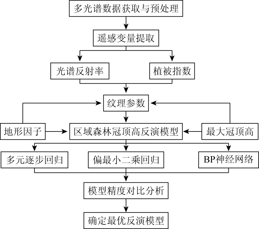
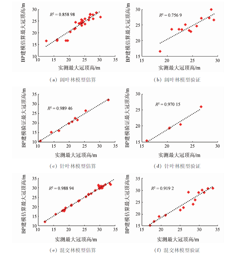
To tackle the problem of low inversion accuracy of regional forest crowns based on optical remote sensing data, in this study the authors used multiple stepwise regression (MSR), partial least squares regression (PLSR) and back-propagation (BP) network models to perform regional forest crown height inversion based on the texture, spectral and topographic characteristics of SPOT5 multispectral images. The inversion accuracy of the models was compared and analyzed to determine the optimal model for the study area. The results show that the correlation between the texture parameters of each forest type and the measured canopy height of the plot is better than other spectral parameters. The BP neural network model performs better than other models, and the determination coefficients R2 of the validation results for the broad-leaved, coniferous, and mixed forest were 0.76, 0.97 and 0.92, respectively, and the root mean square error (RMSE) were 1.6 m, 1.35 m and 2.29 m, respectively. Studies have shown that texture parameters can reflect the structural characteristics of forest canopy well, and the BP neural network model combining image texture, spectrum and terrain feature parameters has good application potential in forest canopy height inversion.
高凯旋, 焦海明, 王新闯. 融合影像纹理、光谱与地形特征的森林冠顶高反演模型[J]. 国土资源遥感, 2020, 32(3): 63-70.
GAO Kaixuan, JIAO Haiming, WANG Xinchuang. Inversion model of forest canopy height based on image texture,spectral and topographic features. Remote Sensing for Land & Resources, 2020, 32(3): 63-70.
Zhang J P, Zhang L B, Liu C L, et al. Estimation of carbon storage and carbon sequestration potential of mid-subtropical forest vegetation in Jinggang Mountain[J]. Ecology and Eevironmental Sciences, 2016,25(1):9-14.
[2]
Pourrahmati M R, Baghdadi N N, Darvishsefat A A, et al. Capability of GLAS/ICESat data to estimate forest canopy height and volume in mountainous forests of Iran[J]. IEEE Journal of Selected Topics in Applied Earth Observations & Remote Sensing, 2017,8(11):5246-5261.
[3]
Wang Y, Li G, Ding J, et al. A combined GLAS and MODIS estimation of the global distribution of mean forest canopy height[J]. Remote Sensing of Environment, 2016,174(174):24-43.
doi: 10.1016/j.rse.2015.12.005
[4]
Eisfelder C, Kuenzer C, Dech S. Iderivation of biomass information for semi-arid areas using remote-sensing data[J]. International Journal of Remote Sensing, 2012,33(9):2937-2984.
doi: 10.1080/01431161.2011.620034
Lou X T, Zeng Y, Wu B F. Advances in remote sensing estimation of aboveground biomass in forests[J]. Remote Sensing for Land and Resources, 2011,23(1):1-8.doi: 10.6046/gtzyyg.2011.01.01.
Li L, Chen E X, Li Z Y, et al. Progress in forest tree height and aboveground biomass estimation of synthetic aperture Radar[J]. Remote Sensing Technology and Application, 2016,31(4):625-633.
doi: 10.11873/j.issn.1004-0323.2016.4.0625
[7]
Feliciano E A, Wdowinski S, Potts M D, et al. Estimating mangrove canopy height and above-ground biomass in everglades national park with airbone LiDAR and TanDEM-X data[J]. Remote Sensing, 2017,9(7):702.
doi: 10.3390/rs9070702
[8]
Wang M, Sun R, Xiao Z. Estimation of forest canopy height and aboveground biomass from spaceborne LiDAR and Landsat imageries in Maryland[J]. Remote Sensing, 2018,10(2):344.
doi: 10.3390/rs10020344
Dong L X. A method for estimating forest canopy height and biomass in the Three Gorges reservoir area based on multi-source remote sensing data[D].Beijing:Institute of Remote Sensing Applications, Chinese Academy of Sciences, 2008.
Huang K B, Pang Y, Shu Q T, et al. In-situ biomass inversion of forests in Yunnan Province based on ICESat GLAS[J]. Journal of Remote Sensing, 2013,17(1):169-183.
Dong L X, Wu B F, Tang S H. Reconstruction of forest aboveground biomass by LiDAR GLAS and ETM[J]. Journal of Peking University(Natural Science), 2011,47(4):703-710.
Wu D, Fan W Y. Retrieving tree height from LiDAR and multi-angle optical remote sensing data[J]. Journal of Beijing Forestry University, 2014,36(4):8-15.
Yang T, Wang C, Li G C, et al. Height mapping of Chinese forest canopy based on spaceborne laser Radar GLAS and optical MODIS data[J].Science in China(Earth Science) 2014(11):2487-2498.
[14]
Yu Y, Yang X G, Fan W Y. Estimates of forest structure parameters from GLAS data and multi-angle imaging spectrometer data[J]. International Journal of Applied Earth Observations and Geoinformation, 2015,38:65-71.
doi: 10.1016/j.jag.2014.12.013
Qiu S, Xing Y Q, Tian J, et al. Joint estimation of regional canopy height by satellite LiDAR and HJ-1A/HSI hyperspectral data[J]. Forestry Science, 2016,52(5):142-149.
Sun H, Ju H B, Zhang H Q, et al. Tree crown extraction and tree height inversion based on Worldview-2 imagery[J].Journal of Central South University of Forestry and Technology 2014(10):45-50.
[17]
Majdar R S, Ghassemian H. A probabilistic SVM approach for hyperspectral image classification using spectral and texture features[J]. International Journal of Remote Sensing, 2017,38(15):4265-4284.
doi: 10.1080/01431161.2017.1317941
[18]
Kayitakire F, Hamel C, Defourny P. Retrieving forest structure variables based on image texture analysis and IKONOS-2 imagery[J]. Remote Sensing of Environment, 2006,102(3):390-401.
doi: 10.1016/j.rse.2006.02.022
[19]
Gebreslasie M T, Ahmed F B, Aardt J. Extracting structural attributes from IKONOS imagery for Eucalyptus plantation forests in KwaZulu-Natal,South Africa,using image texture analysis and artificial neural networks[J]. International Journal of Remote Sensing, 2011,32(22):7677-7701.
doi: 10.1080/01431161.2010.527392
[20]
Beguet B, Guyon D, Boukir S, et al. Automated retrieval of forest structure variables based on multi-scale texture analysis of VHR satellite imagery[J]. ISPRS Journal of Photogrammetry & Remote Sensing, 2014,96(4):164-178.
[21]
Zhu J, Huang Z, Sun H, et al. Mapping forest ecosystem biomass density for Xiangjiang River basin by combining plot and remote sensing data and comparing spatial extrapolation methods[J]. Remote Sensing, 2017,9(3):241-264.
doi: 10.3390/rs9030241
Guo Y, Li Z Y, Chen E X, et al. Multispectral remote sensing estimation of aboveground biomass of forests in the upper reaches of Heihe River basin in Gansu Province[J]. Forestry Science, 2015,51(1):140-149.
[23]
Luo S Z, Wang C, Xi X H, et al. Fusion of airborne LiDAR data and hyperspectral imagery for aboveground and belowground forest biomass estimation[J]. Ecological Indicators, 2017,73.
pmid: 31413664
Xu H, Pan P, Ning J K, et al. Application of multiple linear regression and neural network model in remote sensing estimation of forest aboveground biomass[J]. Journal of Northeast Forestry University, 2018,46(1):65-69.
[25]
Ingram J C, Dawson T P, Whittaher R J. Mapping tropical forest structure in south-eastern adagascar using remote sensing and artificial neural networks[J]. Remote Sensing of Environment, 2005,94(4):491-507.
doi: 10.1016/j.rse.2004.12.001
Guo Y K, Zeng F. Comparison of atmospheric correction of SPOT 5 image based on FLAASH and QUAC model[J]. Bulletin of Surveying and Mapping, 2012,(11):21-23.
[27]
Castillo M A, Ricker M, Jong B H J D.Estimation of tropical forest structure from SPOT-5 satellite images[J]. ISPRS Journal of Photogrammetry & Remote Sensing, 2010,31(10):2767-2782.
Chen L, Hao W Q, Gao D L, et al. Recent advances in optical image texture information in forestry[J]. Journal of Beijing Forestry University, 2015,37(3):1-12.
Dong L X, Rong Z G, Li G C, et al. Joint inversion of LiDAR and MERSI in the height of forest top in Jilin Changbai Mountain[J]. Journal of Wuhan University(Information Science Edition), 2011,36(9):1020-1024.
Liao K T, Qi S H, Wang C, et al. Forest height and biomass mapping in Jiangxi Province based on GLAS and TM satellite data[J]. Remote Sensing Technology and Application, 2018,33(4):713-720.
[31]
Eckert S. Improved forest biomass and carbon estimations using texture measures from WorldView-2 satellite data[J]. Remote Sensing, 2012,4(4):810-829.
doi: 10.3390/rs4040810
[32]
Kelsey K C, Neff J C. Estimates of aboveground biomass from texture analysis of Landsat imagery[J]. Remote Sensing, 2014,6(7):6407-6422.
doi: 10.3390/rs6076407
[33]
Shamsoddini A, Turner R, Turner R. Pine plantation structure mapping using WorldView-2 multispectral image[J]. International Journal for Remote Sensing, 2013,34(11):3986-4007.
doi: 10.1080/01431161.2013.772308
[34]
Gallardocruz J A, Meave J A, González E J, et al. Predicting tropical dry forest successional attributes from space:Is the key hidden in image texture?[J]. Plos One, 2012,7(2):e30506.
doi: 10.1371/journal.pone.0030506
pmid: 22363443
Xie S Q, Zhao T Z, Wang W, et al. Inversion of forest structure parameters based on image texture,spectral and topographic features[J]. Transactions of the Chinese Society of Agricultural Machinery, 2017,48(4):125-134.
 2020, Vol. 32
  ), 焦海明, 王新闯(