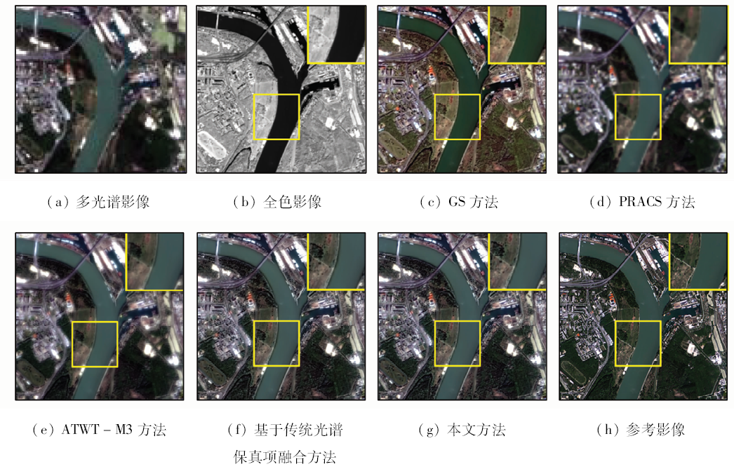
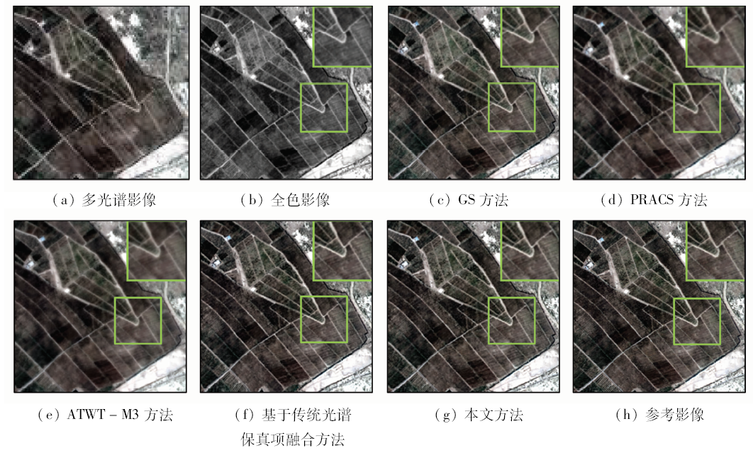
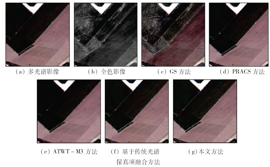
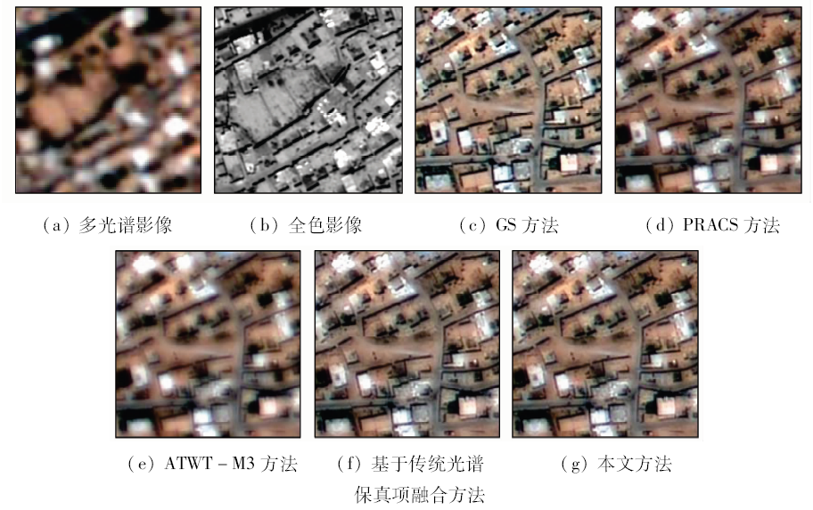
The current panchromatic (PAN) / multispectral (MS) fusion methods do not comprehensively consider the characteristics of the remote sensing images from China’s domestic high-resolution satellites. Therefore, this paper proposes a variational fusion method for China’s domestic high-resolution images. On the one hand, the three-dimensional spectral high-fidelity model based on the spectral gradient is proposed by comprehensive consideration of the relations between the spectral bands. On the other hand, according to the existing blurring characteristics of the PAN image acquired by China’s domestic high-resolution satellites, the spatial enhancement model in consideration of the blurring degradation is developed. Finally, the fusion energy function is constructed by combining the prior knowledge of the remote sensing images, and it is solved by the classical gradient decent methods to obtain the fused image. The proposed method was tested and verified by the Gaofen-1 (GF-1) and Gaofen-2 (GF-2) satellite datasets. In addition, the popular GS, PRACS, and ATWT-M3 methods were applied for comparison from both qualitative and quantitative aspects. The experimental results show that the proposed variational high-fidelity PAN/MS fusion method comprehensively considers the characteristics of China’s domestic satellites, and hence it can maximally preserve the spectral information while effectively improve the spatial resolution of the MS images, thus achieving the best fused results.
Shen H F, Meng X C, Zhang L P . An integrated framework for the spatio-temporal-spectral fusion of remote sensing images[J]. IEEE Transactions on Geoscience and Remote Sensing, 2016,54(12):7135-7148.
doi: 10.1109/TGRS.2016.2596290
Zhang L P, Shen H F . Progress and future of remote sensing data fusion[J]. Journal of Remote Sensing, 2016,20(5):1050-1061.
[3]
Aiazzi B, Alparone L, Baronti S , et al. Twenty-five years of pansharpening:A critical review and new developments[M] //Chen C H.Signal and Image Processing for Remote Sensing. 2nd edition.Boca Raton,FL: CRC Press, 2012: 533-548.
[4]
Vivone G, Alparone L, Chanussot J , et al. A critical comparison among pansharpening algorithms[J]. IEEE Transactions on Geoscience and Remote Sensing, 2014,53(5):2565-2586.
doi: 10.1109/IGARSS.2014.6946389
[5]
Chavez Jr P S, Sides S C, Anderson J A . Comparison of three different methods to merge multiresolution and multispectral data: Landsat TM and SPOT panchromatic[J]. Photogrammetric Engineering and Remote Sensing, 1991,57(3):295-303.
doi: 10.1163/157006707X222768
[6]
Laben C A, Brower B V .Process for enhancing the spatial resolution of multispectral imagery using pan-sharpening:United States, 6011875[P].2000 -01-04.
[7]
Meng X C, Li J, Shen H F , et al. Pansharpening with a guided filter based on three-layer decomposition[J]. Sensors, 2016,16(7):1068.
doi: 10.3390/s16071068
pmid: 4970115
[8]
Ranchin T, Wald L . Fusion of high spatial and spectral resolution images:The ARSIS concept and its implementation[J]. Photogrammetric Engineering and Remote Sensing, 2000,66(1):49-61.
doi: 10.1002/2014WR016042
[9]
Alparone L, Aiazzi B . MTF-tailored multiscale fusion of high-resolution MS and Pan imagery[J]. Photogrammetric Engineering and Remote Sensing, 2006,72(5):591-596.
doi: 10.14358/PERS.72.5.591
Li W J, Wen W P, Wang Q H . A study of remote sensing image fusion method based on Contourlet transform[J]. Remote Sensing for Land and Resources, 2015,27(2):44-50.doi: 10.6046/gtzyyg.2015.02.07.
[11]
Tu T M, Su S C, Shyu H C , et al. A new look at IHS-like image fusion methods[J]. Information Fusion, 2001,2(3):177-186.
doi: 10.1016/S1566-2535(01)00036-7
[12]
Meng X C, Shen H F, Li H F, et al. Improving the spatial resolution of hyperspectral image using panchromatic and multispectral images:An integrated method [C]//Proceedings of the 7th Workshop on Hyperspectral Image and Signal Processing:Evolution in Remote Sensing (WHISPERS).Tokyo,Japan:IEEE, 2015: 1-4.
Meng X C, Shen H F, Zhang H Y , et al. Maximum a posteriori fusion method based on gradient consistency constraint for multispectral/panchromatic remote sensing images[J]. Spectroscopy and Spectral Analysis, 2014,34(5):1332-1337.
[14]
Meng X C, Shen H F, Zhang L P, et al. A unified framework for spatio-temporal-spectral fusion of remote sensing images [C]//Proceedings of IEEE International Geoscience and Remote Sensing Symposium (IGARSS).Milan,Italy:IEEE, 2015: 2584-2587.
[15]
Zhang L P, Shen H F, Gong W , et al. Adjustable model-based fusion method for multispectral and panchromatic images[J]. IEEE Transactions on Systems,Man,and Cybernetics,Part B (Cybernetics), 2012,42(6):1693-1704.
doi: 10.1109/TSMCB.2012.2198810
pmid: 22736648
[16]
Ballester C, Caselles V, Igual L , et al. A variational model for P+XS image fusion[J]. International Journal of Computer Vision, 2006,69(1):43-58.
doi: 10.1007/s11263-006-6852-x
[17]
Palsson F, Sveinsson J R, Ulfarsson M O . A new pansharpening algorithm based on total variation[J]. IEEE Geoscience and Remote Sensing Letters, 2014,11(1):318-322.
doi: 10.1109/LGRS.2013.2257669
[18]
Shen H F, Zhang L P, Huang B , et al. A MAP approach for joint motion estimation,segmentation, and super resolution[J]. IEEE Transactions on Image Processing, 2007,16(2):479-490.
doi: 10.1109/TIP.2006.888334
pmid: 17269640
[19]
Li H F, Zhang L P, Shen H F , et al. A variational gradient-based fusion method for visible and SWIR imagery[J]. Photogrammetric Engineering and Remote Sensing, 2012,78(9):947-958.
doi: 10.14358/PERS.78.9.947
[20]
Wang Z, Bovik A C . Mean squared error:Love it or leave it? A new look at signal fidelity measures[J]. IEEE Signal Processing Magazine, 2009,26(1):98-117.
doi: 10.1109/MSP.2008.930649
[21]
Wald L. Quality of high resolution synconfproced images: Is there a simple criterion? [C]//Proceedings of the 3rd Conference “Fusion of Earth Data:Merging Point Measurements,Raster Maps and Remotely Sensed Images”. Sophia Antipolis,France:SEE/URISCA, 2000: 99-103.
[22]
Choi J, Yu K, Kim Y . A new adaptive component-substitution-based satellite image fusion by using partial replacement[J]. IEEE Transactions on Geoscience and Remote Sensing, 2011,49(1):295-309.
doi: 10.1109/TGRS.2010.2051674
[23]
Wald L, Ranchin T, Mangolini M . Fusion of satellite images of different spatial resolutions:Assessing the quality of resulting images[J]. Photogrammetric Engineering And Remote Sensing, 1997,63(6):691-699.
doi: 10.1016/S0924-2716(97)00008-7
 2018, Vol. 30
  ), 孟祥超2(