SBAS-InSAR-based monitoring and inversion of surface subsidence of the Shadunzi Coal Mine in Hami City, Xinjiang
SHA Yonglian1,2(), WANG Xiaowen1,3(), LIU Guoxiang1,3, ZHANG Rui1,3, ZHANG Bo1
1. Faculty of Geosciences and Environmental Engineering, Southwest Jiaotong University, Chengdu 611756, China 2. Beijing Institute of Technology Chongqing Innovation Center, Chongqing 401120, China 3. State-province Joint Engineering Laboratory of Spatial Information Technology of High-speed Railway Safety, Chengdu 611756, China
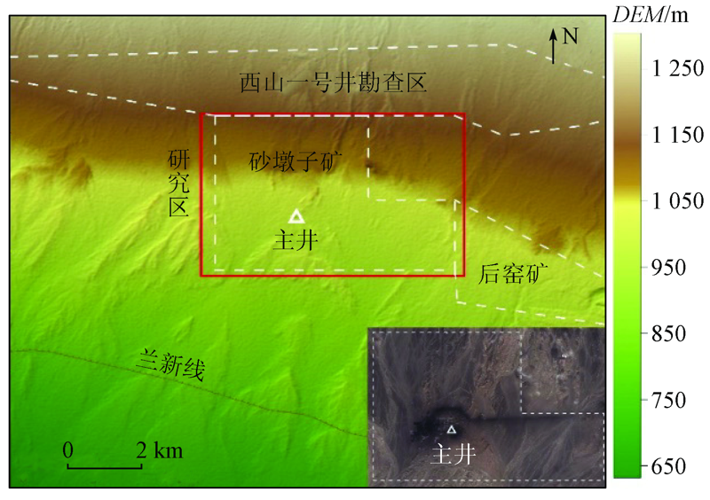
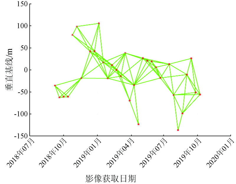
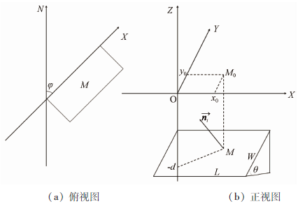
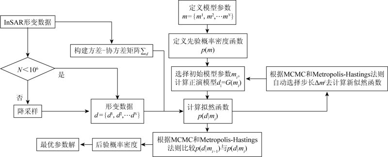
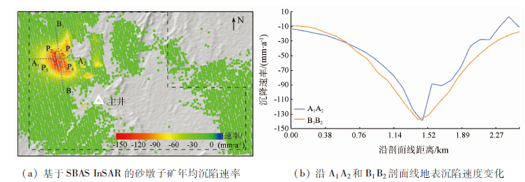
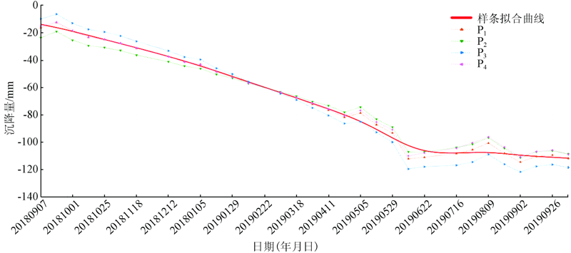
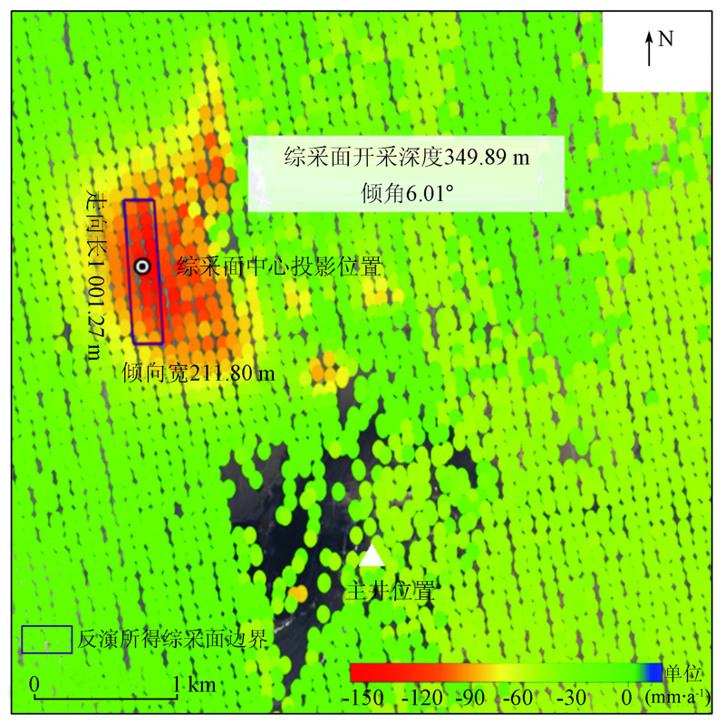
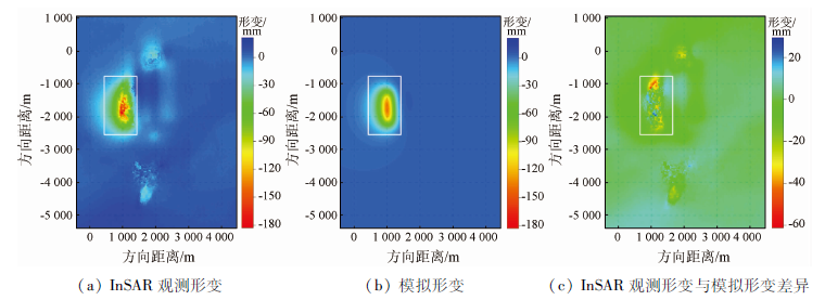
The monitoring of surface subsidence in mining areas can provide key information for local production safety protection and mining planning and management. Based on the Sentinel-1A images from September 2018 to October 2019, this study characterized the surface subsidence in the mining area of the Shadunzi Coal Mine in Hami City, Xinjiang, China using the combined small baseline subset (SBAS) and interferometric synthetic aperture radar (InSAR) analysis. The InSAR measurement results revealed a subsidence funnel with a maximum subsidence rate of about -150 mm/a to the northwest of the main shaft of the coal mine. As indicated by the displacement time series, the subsidence funnel showed a significant linear subsidence pattern from September 2018 to June 2019 and gradually stabilized thereafter. Then the surface deformation inversion was conducted using the Okada rectangular dislocation model to obtain the parameters of the working face of the coal mine. The modeling results showed that the working face had a depth of about 349.89 m, a length of about 1 001.27 m, and a width of about 211.80 m. Based on the inversion results as well as the apparent density of the coal seams, the annual mining capacity of the coal mine was estimated to be about 3.18 Mt during 2018—2019, which is consistent with the reported annual production capacity of the coal mine. This paper provides a feasible way to conduct the parameter inversion of coal mine working face under the constraints of InSAR measurements and to infer the relationship between the working face parameters and the mining capacity according to the apparent density of coal seams.
沙永莲, 王晓文, 刘国祥, 张瑞, 张波. 基于SBAS InSAR的新疆哈密砂墩子煤田开采沉陷监测与反演[J]. 自然资源遥感, 2021, 33(3): 194-201.
SHA Yonglian, WANG Xiaowen, LIU Guoxiang, ZHANG Rui, ZHANG Bo. SBAS-InSAR-based monitoring and inversion of surface subsidence of the Shadunzi Coal Mine in Hami City, Xinjiang. Remote Sensing for Natural Resources, 2021, 33(3): 194-201.
Zhu J J, Li Z W, Hu J. Research progress and methods of InSAR for deformation monitoring[J]. Acta Geodaetica et Cartographica Sinica, 2017, 46(10):1717-1733.
Wang Z Y, Zhang J X, Huang G M. Precise monitoring and analysis of the land subsidence in Jining coal mining area based on InSAR technique[J]. Journal of China University of Mining & Technology, 2014, 43(1):169-174.
Ma F H, Jiang S S, Sun C Y. Application of PSInSAR in monitoring land subsidence in Yanshan mining area[J]. Journal of Applied Sciences-Eletronics and Information Engineering, 2018, 36(6):95-103.
Li D R. InSAR Technological progress and its application to land subsidence monitoring[J]. Shanghai Land & Resources, 2013, 34(4):1-6.
[7]
Zebker H A, Rosen P A, Hensley S. Atmospheric effects in interferometric synthetic aperture radar surface deformation and topographic maps[J]. Journal of Geophysical Research, 1997, 102(B4):7547-7563.
doi: 10.1029/96JB03804
[8]
Ferretti A, Prati C, Rocca F. Non-linear subsidence rate estimation using permanent scatterers in differential SAR interferometry[J]. IEEE Transactions on Geoscience and Remote Sensing, 2000, 38(5):2202-2212.
doi: 10.1109/36.868878
Ge D Q, Wang Y, Fan J H, et al. A study of surface deformation monitoring using differential SAR interferometry technique and an analysis of its key problems[J]. Remote Sensing for Land and Resources, 2007, 19(4):14-22.doi: 10.6046/gtzyyg.2007.04.03.
doi: 10.6046/gtzyyg.2007.04.03
[10]
Casu F, Manzo M, Lanari R. A quantitative assessment of the SBAS algorithm performance for surface deformation retrieval from DInSAR data[J]. Remote Sensing of Environment, 2006, 102(3-4):195-210.
doi: 10.1016/j.rse.2006.01.023
[11]
Williams S, Bock Y, Fang P. Integrated satellite interferometry:Tropospheric noise,GPS estimates and implications for interferometric synthetic aperture radar products[J]. Journal of Geophysical Research:Solid Earth, 1998, 103(B11).
Yin H J, Zhu J J, Li Z W. Ground subsidence monitoring in mining area using DInSAR SBAS algorithm[J]. Acta Geodaetica et Cartographica Sinica, 2011, 40(1):52-58.
Zhao W Y, Deng K Z, Yang J K, et al. Monitoring on influence of mining area deformation based on SBAS technology on buildings[J]. Safety in Coal Mines, 2015, 485(2):205-208.
[14]
李达. 时序SAR技术在矿区形变监测中的应用[D]. 徐州:中国矿业大学, 2017.
Li D. Application of timing series SAR technology in deformation monitoring of mining area[D]. Xuzhou:China University of Mining, 2017.
Zhao X. Environmental investigation and assessment based on RS &GIS in Hami Sandaolin mining area[D]. Xi’an:Xi’an University of Science and Technology, 2013.
Li F. Lu’an Xinjiang Coal Chemical Industry (Group) Co.,Ltd.Shadunzi Mine 3.00 Mt/year(Phase 1)mine construction project environmental impact assessment public participation second public notice[R]. Xinjiang:Xinjiang Ecological Environmental Protection Industry Association, 2017.
[20]
Paolo B, Gianfranco F, Riccardo L, et al. A new algorithm for surface deformation monitoring based on small baseline differential SAR interferograms[J]. IEEE Transactions on Geoscience & Remote Sensing, 2002, 40(11):2375-2383.
[21]
Hooper A, Zebker H, Segall P, et al. A new method for measuring deformation on volcanoes and other natural terrains using InSAR persistent scatterers[J]. Geophysical Research Letters, 2004, 31(23):L23611.
[22]
Hooper A. A multi-temporal InSAR method incorporating both persistent scatterer and small baseline approaches[J]. Geophysical Research Letters, 2008, 35(16):L16302.
doi: 10.1029/2008GL034654
Wang Q. A study of ground deformation over Taiyuan City using PS-InSAR technique[J]. Bulletin of Surveying and Mapping, 2014(5):71-75.
[24]
Mostafa E, Mahdi M, Andy H. Application of dual-polarimetry SAR images in multitemporal InSAR processing[J]. IEEE Geoscience & Remote Sensing Letters, 2017, PP(99):1-5.
[25]
Okada Y. Surface deformation due to shear and tensile faults in a half-space[J]. Bull.Seismol.Soe.Am., 1985, 75(4):1135-1154.
[26]
Okada Y. Internal deformation due to shear and tensile faults in a half-space[J]. Bull.Seismol.Soe.Am., 1992, 82(2):1018-1040.
[27]
Yang X M, Davis P M, Dieterich J H. Deformation from inflation of a dipping finite prolate spheroid in an elastic half-space as a model for volcanic stressing[J]. Journal of Geophysical Research:Solid Earth, 1988, 93(B5):4249-4257.
[28]
Carnec C, Fabriol H. Monitoring and modeling land subsidence at the Cerro Prieto Geothermal Field,Baja California,Mexico,using SAR interferometry[J]. Geophysical Research Letters, 1999, 26(9):1211-1214.
doi: 10.1029/1999GL900062
[29]
杨崇. 辽河油田地表沉降InSAR监测及储层参数反演[D]. 成都:西南交通大学, 2019.
Yang C. Surface subsidence InSAR monitoring and reservoir parameter inversion in liaohe oilfield[D]. Chengdu:Southwest Jiaotong University, 2019.
State Administration of Work Safety State Council. No.61—2014 Verification standard of coal mine production capacity[S]. Beijing:Safety Supervision General Coal Bank, 2014.
 2021, Vol. 33
  ), 王晓文1,3(