1. College of Architecture and Urban Planning, Tongji University, Shanghai 200092, China 2. College of Surveying and Geo-Informatics, Tongji University, Shanghai 200092, China 3. School of Resource and Environmental Sciences, Wuhan University, Wuhan 430072, China 4. Urban Mobility Institute, Tongji University, Shanghai 200092, China
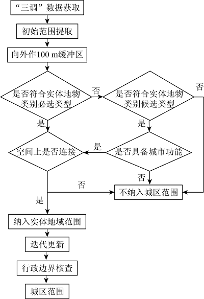
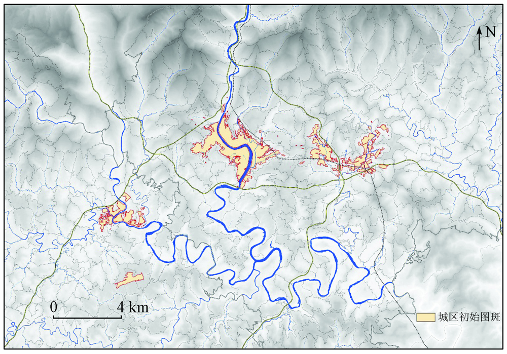
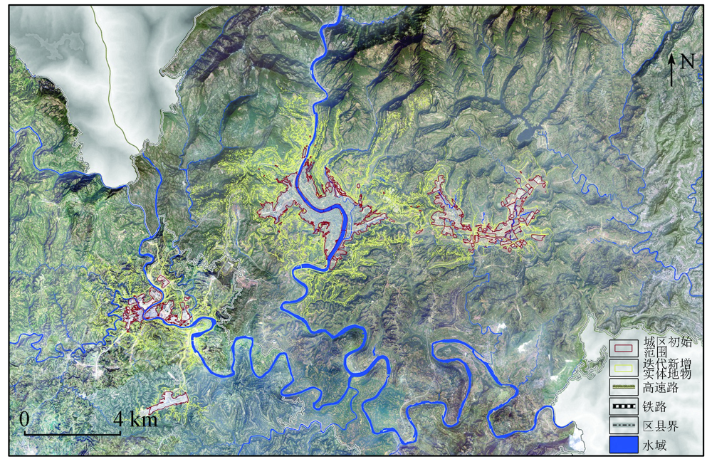
The scientific and reasonable delineation of an urban area serves as an important basis for making urban and rural statistics, formulating urban and rural policies, and implementing land space planning. At present, a unified concept system and unified delimitation methods of urban areas are yet to be established, which brings a lot of uncertainty to the formulation and implementation of land space planning. Therefore, aiming at the problems of the fuzzy concept, inconsistent demarcation methods, unclear spatial boundaries, this paper defined the spatial connotation of urban areas based on extensive research and proposed the spatial delimitation method of urban areas using surveying and mapping geographic information and the techniques such as remote sensing. Based on the data of the Third National Land Survey, this study determined the surface features incorporated into urban areas according to urban land use characteristics and spatial connection successively, in order to extract the spatial scopes of urban areas. Finally, taking Bazhong City as a case study, the rationality and feasibility of the process were verified, indicating that the method can be used in the extraction of the spatial scopes of urban areas and has the value of widespread applications.
Qi W, Wang K Y. City administrative area and physical area in China:Spatial differences and integration strategies[J]. Geographical Research, 2019,38(2):207-220.
State Statistics Bureau. Provisions for the statistical division of urban and rural areas[EB/OL]. http://www.stats.gov.cn/tjsj/tjbz/200610/t20061018_8666.html.
[7]
汪阳. 我国城乡划分标准研究[D]. 成都:西南交通大学, 2012.
Wang Y. Research on the standards of urban and rural division in China[D]. Chengdu:Southwest Jiaotong University, 2012.
[8]
冯健. 城乡划分与监测[M]. 北京: 科学出版社, 2012.
Feng J. Urban and rural division and monitoring[M]. Beijing: Science Press, 2012.
Xu Q, Hua C. Establishing a uniform standard for calculation of urban built-up area:With Hangzhou central city zone as an example[J]. Planners, 2005(4):88-91.
Hua C, Hong Y D, Wang Y F, et al. The concept and definition of urban built-up area:A case of Wukang Town in Zhejiang Province[J]. Urban Planning Forum, 2013(2):57-62.
Research group of “Strategy and Policy Research on Urbanization with Chinese Characteristics”,Development Research Center of the State Council, Hou Y C, Han J, et al. International experience and enlightenment on the division of urban and rural spatial boundaries[J]. China Development Observation, 2010(7):54-57.
Hui Y, Jin Z F, Chen W. Study on urban-rural Area division and urban population counting——The case of Changshu City[J]. Areal Research and Development, 2009,28(1):42-46.
Song X D, Liu P, Zhou Y X. The division of urban and rural entities in Shanghai[J]. Acta Geographica Sinica, 2006(8):787-797.
[16]
Friedl M A, Mciver D K, Hodges J, et al. Global land cover mapping from MODIS:Algorithms and early results[J]. Remote Sensing of Environment, 2002,83(1-2):287-302.
doi: 10.1016/S0034-4257(02)00078-0
[17]
Gao F, Colstoun E D, Ma R, et al. Mapping impervious surface expansion using medium-resolution satellite image time series:A case study in the Yangtze River Delta,China[J]. International Journal of Remote Sensing, 2012,33(24):7609-7628.
doi: 10.1080/01431161.2012.700424
[18]
Wang H, Ning X, Zhang H, et al. Urban boundary extraction and urban sprawl measurement using high-resolution remote sensing images:A case study of China’s provincial capital[C]//International Archives of the Photogrammetry,Remote Sensing and Spatial Information Sciences, 2018
Zhang L W, Xu L H, Wu C F, et al. The evolution of urban expansion morphology in Hangzhou based on principle of convex hull[J]. Scientia Geographica Sinica, 2015,35(12):42-50.
Deng S B, Wu H G, Jiang T. An approach to the extraction of remotely-sensed information of forest coverage based on PCA/NDVI[J]. Remote Sensing for Land and Resources, 2007(2):82-85.doi: 10.6046/gtzyyg.2007.02.21.
doi: 10.6046/gtzyyg.2007.02.21
Sun Y Y, Zhao J L, Wang M M, et al. Land cover information extraction from remote sensing images using object-based image analysis method integrated with decision tree[J]. Remote Sensing for Land and Resources, 2016(4):156-163.doi: 10.6046/gtzyyg.2016.04.24.
doi: 10.6046/gtzyyg.2016.04.24
[22]
Yin C L, Meng F, Guo L, et al. Extraction and evolution analysis of urban built-up areas in Beijing,1984—2018[J]. Applied Spatial Analysis and Policy, 2021,14:731-753.
doi: 10.1007/s12061-021-09374-7
Hu Y D, Wu Z H, Xiong W, et al. Research on the method of defining urban built-up area:A case study of Wuhan city[J]. City Planning Review, 2008(4):88-91,96.
Liu Z, Liao F F, Zhao T. Remote sensing image urban bulit-up area extraction and optimization method based on PSPNet[J]. Remote Sensing for Land and Resources, 2020,32(4):87-92.doi: 10.6046/gtzyyg.2020.04.12.
doi: 10.6046/gtzyyg.2020.04.12
Chinese Land Surveying and Planning Institute,Division of Natural Resources Survey and Monitoring,Ministry of Natural Resources. TD/T 1055—2019 Technical regulations for the third national land survey[S]. Beijing: Geological Publishing House, 2019.
The State Council. Notice of the State Council on readjustment of the standards for the division of urban dimensions[EB/OL]. http://www.gov.cn/zhengce/content/2014-11/20/content_9225.htm.
Yan X P, Wei L H, Zhou R B. Research on the coordination be-tween urban and rural area in the rapid urbanization with the redevelopment of Guangzhou village-amid-the-city as a case[J]. City Planning Review, 2004(3):30-38.
Zhang X F, Yang Y L, He Z W, et al. Built-up area extraction by RS and urban expansion analysis of Suzhou,Wuxi and Changzhou[J]. Science of Surveying and Mapping, 2011,36(2):113-115.
Office of the Third National Land Survey. Notice of the office of the third national land survey on the issuance of the implementation plan for the third national land survey[EB/OL]. http://gi.mnr.gov.cn/201811/t20181120_2367135.html.
[33]
周晶. 从国际比较和历史演变看我国城镇化统计标准[J]. 中国统计, 2013(7):60-61.
Zhou J. The statistical standard of China’s urbanization from the perspective of international comparison and historical evolution[J]. China Statistics, 2013(7):60-61.
 2021, Vol. 33
  ), 刘春2(