Spatiotemporal analysis of drought in sugarcane planting areas of Guangxi by remote sensing
QIN Wen1,2(), HUANG Qiuyan1,3(), QIN Zhihao4, LIU Jianhong1, WEI Gaoyang1
1. School of Geography Science and Planning, Nanning Normal University, Nanning 530001, China 2. Scientific Research Academy of Guangxi Environmental Protection, Nanning 530022, China 3. Key Laboratory of Environmental Evolution and Resource Utilization of Beibu Gulf, Nanning Normal University, Nanning 530001, China 4. Institute of Agricultural Resources and Regional Planning, Chinese Academy of Agricultural Sciences, Beijing 100081, China
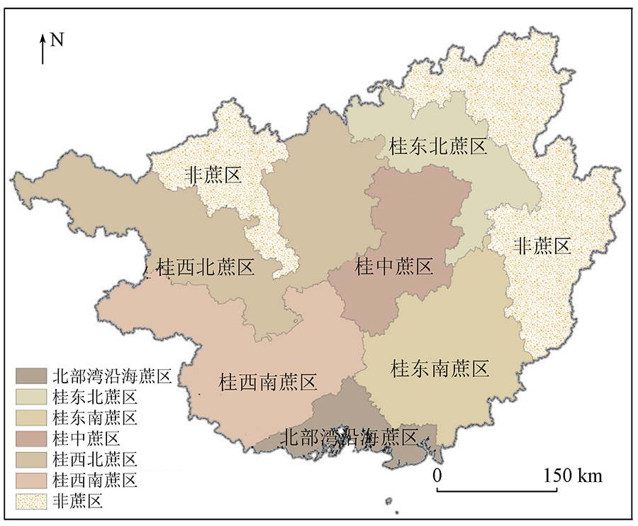
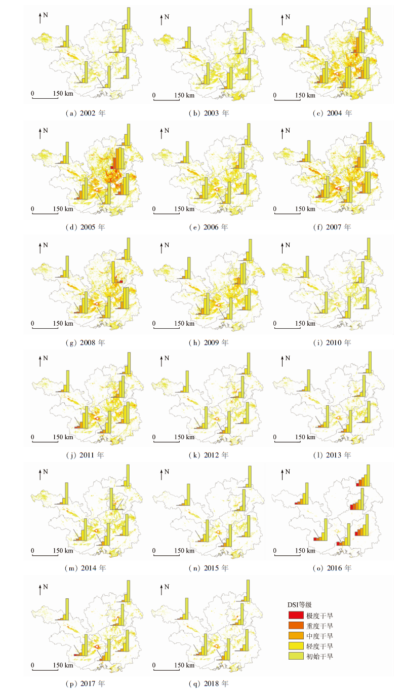
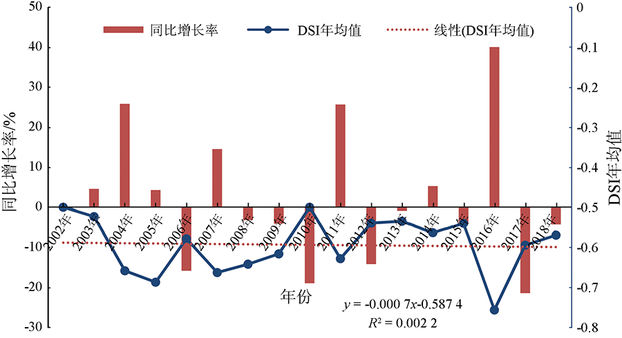
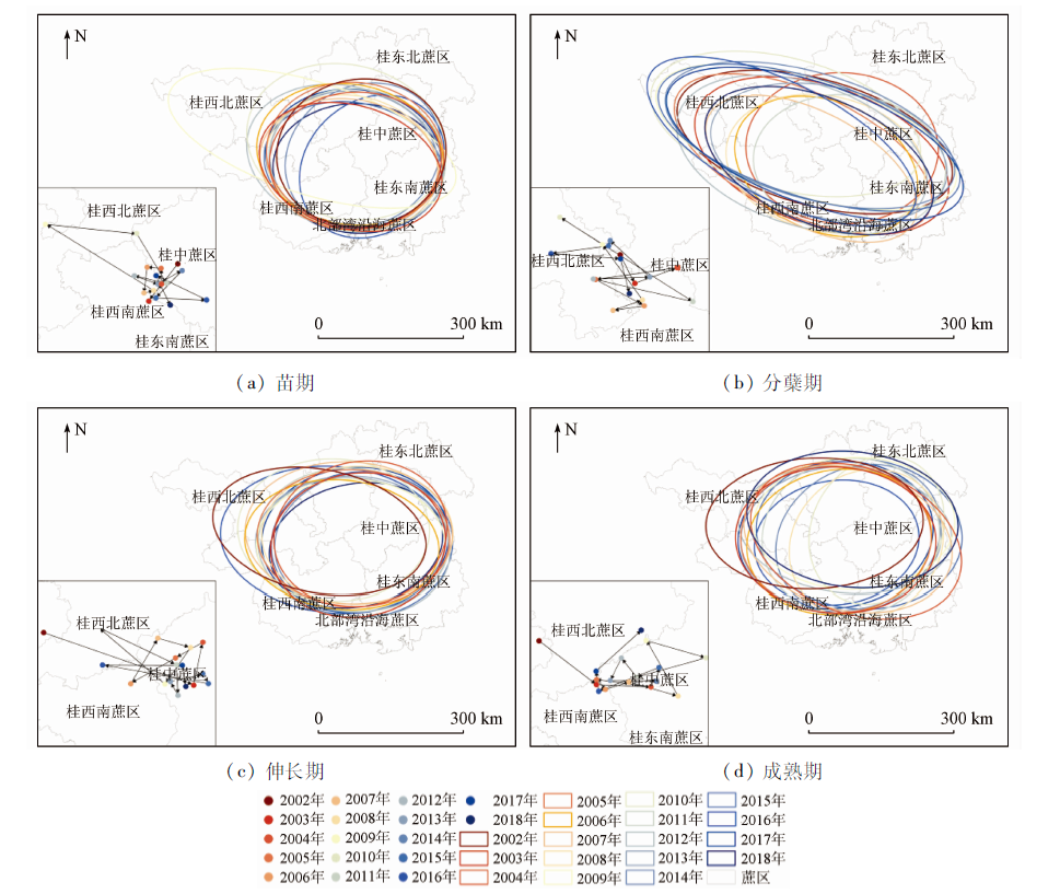
Guangxi is the most important sugarcane producing area in China. Remote sensing of drought in sugarcane planting areas is of great practical significance to decision-making for the anti-drought campaign in Guangxi where sugarcane planting is mainly on the farmland without irrigation guarantee. This study intends to examine the issue of remote sensing monitoring of drought in sugarcane planning areas in Guangxi. MODIS data product MOD16/MYD16 was used to calculate the drought intensity index (DSI) in Guangxi sugarcane planting areas for a period from 2002 to 2018. On the basis of this calculation, the spatiotemporal characteristics of different drought grades in Guangxi sugarcane planting areas were analyzed. In order to reveal the changing trend of the drought severity in the sugarcane planning areas, three methods, i.e. unary linear regression, Mann-Kendall trend test and Hurst index, were used in the study to analyze the change trend of drought in the sugarcane planting areas of Guangxi. The results showed that the drought in Guangxi during the period from 2002 to 2018 mainly happened in the center, the southeast, the southwest, and the northwest sugarcane areas. The annual average of DSI was -0.59 during the period. Very high DSI was observed in two years, i.e. 2010 and 2002, implying that sugarcane planting in Guangxi experienced the most severe drought in the two years. Very low DSI was seen in 2016, indicating the minimal impact of drought on the planting areas this year. The change of DSI in the sugarcane planting areas of Guangxi showed a trend of a slight decrease from 2002 to 2018, with an annual rate of -0.07%. In terms of the spatial center of gravity of drought, the center of gravity of drought areas in different growth periods showed a trend of expansion from the center to the northwest, and the path of gravity center shift was as follows: central planting area > southwest planting area > northwest planting area. From the perspective of years, DSI in each year revealed a remarkable fluctuation during the period in question. Sharp changes in DSI might also be seen in some years, implying that drought had variability among years in Guangxi. The spatiotemporal variation of drought in Guangxi is obviously related to the climate change in the areas. Therefore we believe that sugarcane planting in Guangxi might continuously face the challenges from the frequent occurrence of the drought of various grades as a result of future climate change. Remote sensing monitoring of the drought can provide useful information on drought events and their dynamics for anti-drought campaigns to reduce the impact of drought on sugarcane planting in Guangxi.
Ou Y G. Present situation and countermeasure of whole-process mechanization of sugarcane production in China[J]. Modern Agricultural Equipment, 2019, 40(2):3-8,42.
Nong G, Nong M Z, Wang D. Preliminary refinement analysis of meteorological conditions of Chongzuo sugarcane in Guangxi[J]. Sugar Cane Sugar Industry, 2019(1):10-15.
Wang J X, Zhu X F, Liu X F, et al. Research on agriculture drought monitoring method of Henan Province with multi-sources data[J]. Remote Sensing for Land and Resources, 2018, 30(1):180-186.doi: 10.6046/gtzyyg.2018.01.25.
doi: 10.6046/gtzyyg.2018.01.25
Ren L L, Shen H R, Yuan F, et al. Hydrological drought characteristics in the Weihe catchment in a changing environment[J]. Progress in Water Science, 2016, 27(4):492-500.
Li X Z, Liu X D, Ma Z G. Analysis on the drought characteristics in the main arid regions in the world since recent hundred-odd years[J]. Arid Zone Research, 2004(2):97-103.
Mo J F, Zhong S Q, Chen Y L, et al. Development and application of a monitoring and early warning system for main agro-meteorological disasters in Guangxi Province[J]. Journal of Natural Disasters, 2013, 22(2):150-157.
Kuang Z M. Guangxi agricultural drought monitoring and forecasting and agricultural condition analysis business system V1.0[Z]. Guangxi Zhuang Autonomous Region,Guangxi Institute of Meteorological Disaster Reduction, 2013.
The General Administration of Quality Supervision, Inspection and Quarantine of the People’s Republic of China and the National Standardization Administration of China. GB/T 34809—2017 Sugarcane drought disaster grade[S]. Beijing: China Standards Press, 2017.
Mo J F, Zhong S Q, Chen Y L, et al. GIS-based spatial distribution of drought grades of sugarcane during germination and tillering stage in Guangxi[J]. Jiangsu Agricultural Sciences, 2015, 43(3):113-115.
Chen Y L, Meng L L, Huang X H, et al. Spatial and temporal evolution characteristics of drought in Guangxi during sugarcane growth period based on SPEI[J]. Transactions of the Chinese Society of Agricultural Engineering, 2019, 35(14):149-158.
Li J W, Huang W, Wu X K, et al. Drought risk zone of sugarcane in Liuzhou based on crop water deficit index[J]. Chinese Agricultural Science Bulletin, 2019, 35(22):96-105.
Chen Y L, Huang S Q, Mo J F, et al. Comparison of drought monitoring standards of sugarcane based on CLDAS data:A case of drought in Guangxi in 2011[J]. Arid Meteorology, 2020, 38(2):188-194.
Kuang Z M, Zhu W J, Ding M H, et al. Application of multi-sources satellite data in monitoring sugarcane droughts[J]. China Agricultural Meteorology, 2007(1):93-96.
[18]
Wang P, Gong J, Li X W. Vegetation temperature condition index and its application for drought monitoring[C]// IEEE International Geoscience and Remote Sensing Symposium.IEEE, 2001.
Wen Y Y, Zhao J, Wang Y Q, et al. Spatiotemporal variation characteristics of surface evapotranspiration in Shanxi Province based on MOD16[J]. Progress in Geographical Sciences, 2020, 39(2):255-264.
[20]
Mu Q, Zhao M, Kimball J S, et al. A remotely sensed global terrestrial drought severity index[J]. Bulletin of the American Meteorological Society, 2013, 94(1):83-98.
doi: 10.1175/BAMS-D-11-00213.1
[21]
Haroon M A, Zhang J, Yao F. Drought monitoring and performance evaluation of MODIS-based drought severity index (DSI) over Pakistan[J]. Natural Hazards, 2016, 84(2):1349-1366.
doi: 10.1007/s11069-016-2490-y
Zhang X C, Xu C C, Song J, et al. Analysis of Xinjiang drought characteristics based on remote sensing DSI[J]. Jiangsu Agricultural Sciences, 2020, 48(2):239-246.
Tong D M, Bai Y, Zhang S, et al. Analysis of drought characteristics in Xinjiang area based on remote sensing DSI index[J]. Chinese Agricultural Meteorology, 2020, 41(2):102-112.
Zhang X Q, Feng B, Wang Y Y. Monitoring and evaluation of extreme drought in southwest China based the MODIS:A case study based on 2009—2010 remote sensing data[J]. Environmental Protection Science, 2020, 46(1):135-141.
Yu H Q, Zhang Q, Sun P, et al. Impacts of drought intensity and drought duration on winter wheat yield in five provinces of north China plain[J]. Acta Geographica Sinica, 2019, 74(1):87-102.
Chen Y L, Ding M H, Feng L P, et al. Characteristics of meteorological condition and its effects on ratoon sugarcane in different stages in Guangxi[J]. Meteorological Monthly, 2016, 42(12):1554-1559.
Li X, Liu T X, Duan L M, et al. Crop coefficient simulation and evapotranspiration estimation of dune and meadow in semiarid area[J]. Arid Zone Research, 2020, 37(5):1246-1255.
[28]
Wu X, Wang P J, Huo Z G, et al. Crop drought identification index for winter wheat based on evapotranspiration in the Huang-Huai-Hai Plain,China[J]. Agriculture,Ecosystems and Environment, 2018, 263:18-30.
doi: 10.1016/j.agee.2018.05.001
Liu Q, Yang Y C, Liu H Y. Spatiotemporal evolution characteristics of air pollution degree in 366 cities of China[J]. Arid Land Geography, 2020, 43(3):820-830.
Wei L, Zhang Y, Li Q, et al. Study on spatial variation of China’s territorial ecological space based on standard deviation ellipse[J]. Ecological Economy, 2020, 36(7):176-181.
[32]
魏凤英. 现代气候统计诊断与预测技术[M]. 北京: 气象出版社, 1999.
Wei F Y. Modern climate statistics diagnosis and prediction technology[M]. Beijing: Meteorological Press, 1999.
Zhao R F, Su L, Zhu W. Extreme temperature events in arid region of northwest China during 1961—2012:Seasonal spatio-temporal analysis[J]. Chinese Agricultural Science Bulletin, 2017, 33(12):63-73.
Yue H, Liu Y. Vegetation spatiotemporal variation and its driving factors of Shaanxi Province in recent 15 years[J]. Arid Land Geography, 2019, 42(2):314-323.
Zhang H, An H M. Analysis of NDVI variation characteristics and trend in Minqin oasis from 1987 to 2019 based on GEE[J]. Chinese Desert, 2021, 41(1):28-36.
Zhang Z G, Geng Y X, Cai M T, et al. Spatial-temporal evolution and trend analysis of climatic potential productivity in Henan Province during 1978—2017[J]. Research of Soil and Water Conservation, 2020, 27(6):247-253.
[37]
Ji M, Huang J. Global semi-arid climate change over last 60 years[C]// EGU General Assembly Conference, 2016.
 2022, Vol. 34
  ), 黄秋燕1,3(