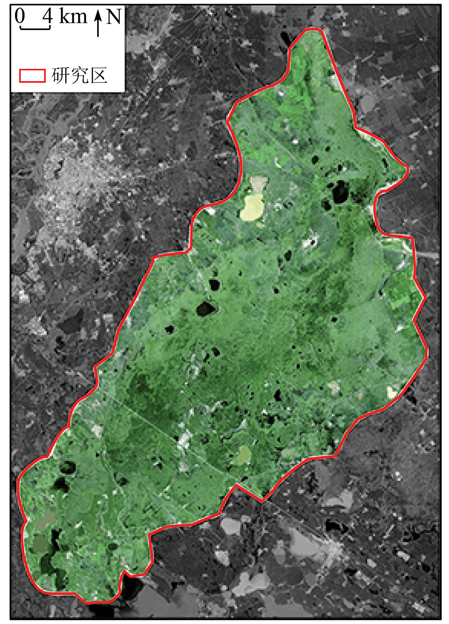
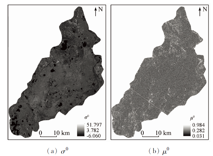
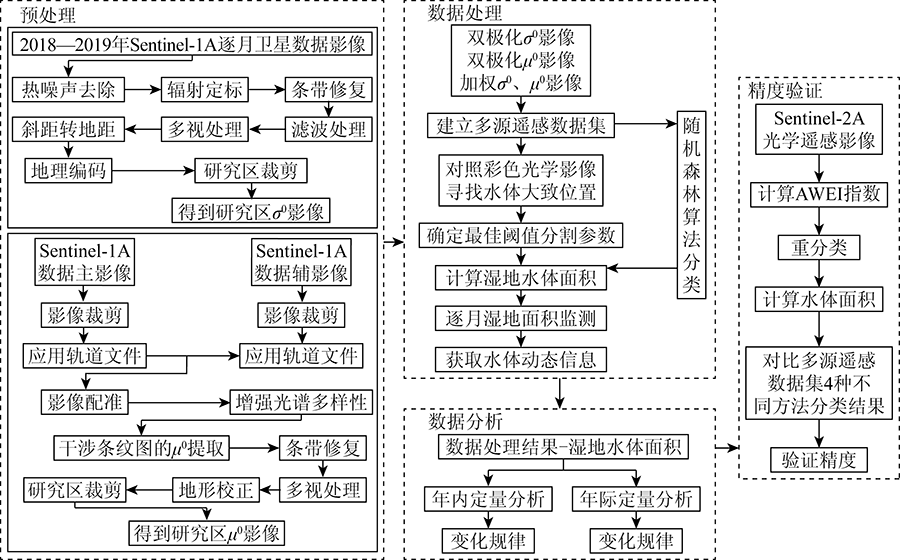
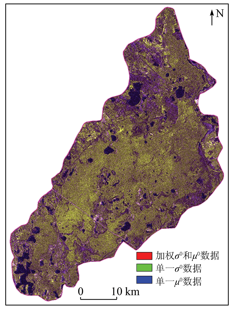
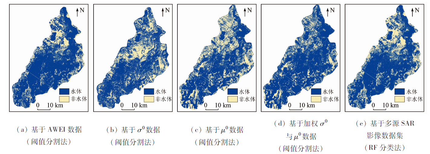
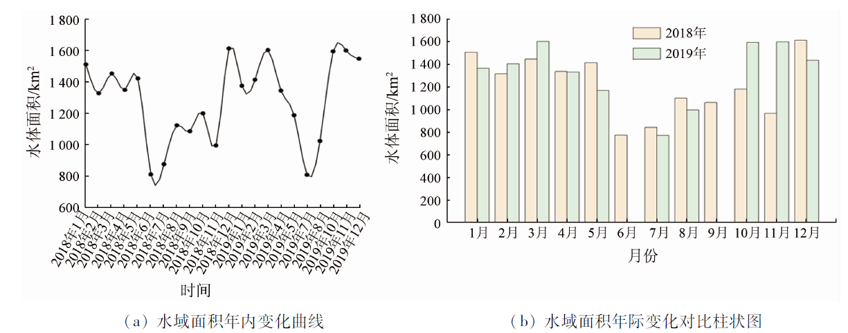
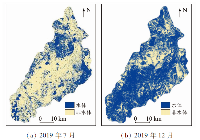
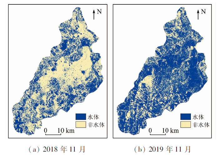
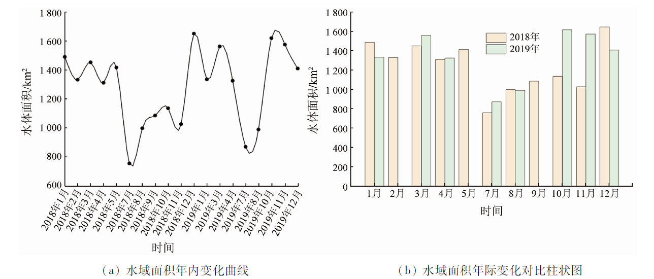
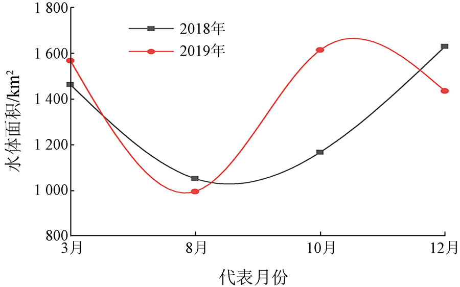
Water is an important factor in the formation and maintenance of wetland ecosystems. Monitoring the changes in the water area of wetlands is of great significance for wetland conservation. Taking Sentinel-1A data from 2018 to 2019 as the data source, this study calculated the intra- and inter-annual synthetic aperture radar (SAR) backscattering coefficient (σ0) and coherence coefficient (μ0) images of the Zhalong Wetland. Then, this study assigned weights according to the proximity to water bodies of color optical images and extracted the weighted images of σ0 and μ0. Finally, this study extracted the wetland water bodies using the threshold segmentation method and random forest algorithm. The purpose is to monitor the dynamic variations in the wetland water area and explore the intra- and inter-annual variation rules of the wetland water body. The results are as follows. The random forest algorithm yielded the highest extraction accuracy of water bodies, with an absolute value of the mean difference of representative months was 6.69 km2. The threshold segmentation method based on μ0 images yielded the lowest classification accuracy of water bodies, with an absolute value of the mean difference of 13.07 km2. Overall, the intra-annual water area of the Zhalong Wetland showed significant seasonal variations during 2018—2019. The water area fluctuated in the ranges of 1 300~1 600 km2 during late spring and early summer and 700~900 km2 during late summer and early autumn. The inter-annual water area varied with conditions such as climate and temperature. In particular, the wetland water area in October and November 2019 was approximately 1 050 km2 greater than that in 2018 due to large amounts of rainfall. As shown by the calculation based on effective data, the water area in 2019 was about 550 km2 greater than that in 2018 in the Zhalong Wetland.
韦嫦, 付波霖, 覃娇玲, 王雅南, 陈智瀚, 刘兵. 基于多时相Sentinel-1A的沼泽湿地水面时空动态变化监测[J]. 自然资源遥感, 2022, 34(2): 251-260.
WEI Chang, FU Bolin, QIN Jiaoling, WANG Yanan, CHEN Zhihan, LIU Bing. Monitoring of spatial-temporal dynamic changes in water surface in marshes based on multi-temporal Sentinel-1A data. Remote Sensing for Natural Resources, 2022, 34(2): 251-260.
Liu Y. Mechanism and pattern analysis of wetland hydrological connectivity:Taking Momoge National Natural as an example[D]. Changchun: Jilin University, 2020.
Wang Q J, Wang X Q, Lu S L, et al. The basis of economic theory on the ecological compensation and its practice in China[J]. Forestry Economy, 2019, 41(1): 3-23.
Li D, Wu B S, Chen B W, et al. Review of water body information extraction based on satellite remote sensing[J]. Journal of Tsinghua University (Natural Science Edition), 2020, 60(2):147-161.
[6]
甄佳宁. 基于多时相遥感的长春湿地动态变化研究[D]. 长春: 吉林大学, 2016.
Zhen J N. The research of wetland dynamic change in Changchun based on multi-temporal remote sensing[D]. Changchun: Jilin University, 2016.
[7]
Jin H R, Huang C Q, Megan W L, et al. Monitoring of wetland inundation dynamics in the Delmarva Peninsula using Landsat time-series imagery from 1985 to 2011[J]. Remote Sensing of Environment, 2017, 190:26-41.
doi: 10.1016/j.rse.2016.12.001
Chang W T, Chen H, Chang W G. Time series Sentinel-1 data and object-oriented wetland information extraction method[J]. Beijing Surveying and Mapping, 2020, 34(3):365-370.
Fu B L, Lan F W, Deng T F, et al. Monitoring of relative variation of water level of marshes in Honghe National Nature Reserve using DInSAR technique[J]. Wetland Science, 2021, 19(1): 27-39.
[11]
贺广均. 联合SAR与光学遥感数据的山区积雪识别研究[D]. 南京: 南京大学, 2015.
He G J. Snow recognition in mountain areas based on SAR and optical remote sensing data[D]. Nanjing: Nanjing University, 2015.
Guan Y T. Inversion of soil moisture in plateau wetland based on SAR and optical data[D]. Kunming: Yunnan Normal University, 2019.
[13]
Mizuochia H, Hiyama T, Ohta T, et al. Development and evaluation of a lookup-table-based approach to data fusion for seasonal wetlands monitoring: An integrated use of AMSR series,MODIS,and Landsat[J]. Remote Sensing of Environment, 2017, 199: 370-388.
doi: 10.1016/j.rse.2017.07.026
Chang W T, Wang H, Ning X G, et al. Extraction of Zhalong wetlands information based on images of Sentinel-2 red-edge bands and Sentinel-1 Radar bands[J]. Wetland Science, 2020, 18(1): 10-19.
Li Z, Gong Z N, Liu X L, et al. Vegetation coverage retrieval and spatio-temporal distribution based on object-oriented multi-terminal mixed model[J]. Remote Sensing Technology and Application, 2018, 33(6):1149-1158.
Liu Y, Yu Z Q, Fan J P, et al. The characters of backscattering coefficient during flood period in Poyang Lake[J]. Journal of Central China Normal University (Natural Science Edition), 2019, 53(2):283-289.
Jia L L, Wang X Q, Wang F. Cloud detection based on band operation texture feature for GF-1 multispectral data[J]. Remote Sensing Information, 2018, 33(5):62-68.
Wang J. Joint 3D head pose and face landmarks regression based on classification-guided method[D]. Hefei: University of Science and Technology of China, 2017.
[19]
Gudina L F, Henrik M, Rasmus F, et al. Automated water extraction index: A new technique for surface water mapping using Landsat imagery[J]. Remote Sensing of Environment, 2014, 140:23-35.
doi: 10.1016/j.rse.2013.08.029
Wang Y F, Xu H Q. Comparison of remote sensing water indices based on objective threshold value and the random forest gini coefficient[J]. Remote Sensing Technology and Application, 2020, 35(5):1089-1098.
 2022, Vol. 34
  ), 付波霖(