1. College of Resources and Environmental Engineering, Ludong University, YanTai 264025, China 2. Key Laboratory of Quantitative Remote Sensing Information Technology, Academy of Opto-Electronics, Chinese Academy of Sciences, Beijing 100094, China
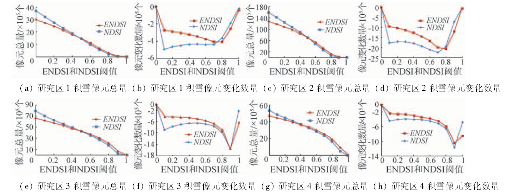
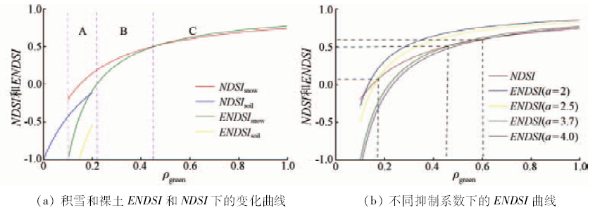
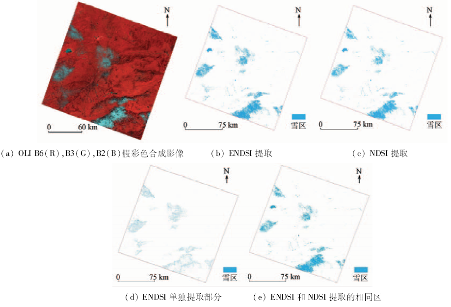
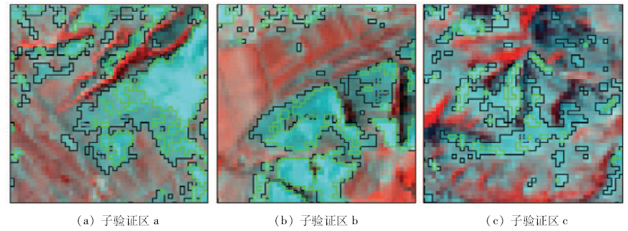
Detecting snow cover information and snow space-time distribution quickly and accurately is a basic problem of ecological environment changes in the resources. Remote sensing technology effectively provides technical support for solving this problem. Normalized difference snow index (NDSI) is an important method for automatic extracting snow cover information using spectral features of snow, which have high reflection in the green band (0.53~0.59 μm) and strong absorption characteristics in short wave infrared band (1.57~1.65 μm). By using Landsat8 OLI images as the data source and according to the spectral characteristics of snow, the authors propose the enhanced normalized difference snow index (ENDSI) based on adding emissivity characteristics of snow in first band B1 (0.433~0.453 μm) and second band B2 (0.450~0.515 μm), and the utilization of this index to extract snow from OLI images. Simulation and case study results show the following characteristics: the sensitivity of ENDSI is stronger than that of NDSI for the snow thickness; with the increase of the thickness of snow, the change of ENDSI value is stronger than that of NDSI; ENDSI can effectively increase the difference between snow and non-snow; it is easy to extract snow from the image with 0.3 as ENDSI threshold and, in this way, snow extraction accuracy is improved.
庞海洋, 孔祥生, 汪丽丽, 钱永刚. ENDSI增强型雪指数提取积雪研究[J]. 国土资源遥感, 2018, 30(1): 63-71.
Haiyang PANG, Xiangsheng KONG, Lili WANG, Yonggang QIAN. A study of the extraction of snow cover using nonlinear ENDSI model. Remote Sensing for Land & Resources, 2018, 30(1): 63-71.
Jones H G,Pomeroy J W,Walker D A,et al.Snow Ecology:An Interdisciplinary Examination of Snow-covered Ecosystems[M].Cambridge:Cambridge University Press,2001.
Bai S Y,Wu Q,Shi J Q,et al.Relationship between the spatial and temporal distribution of snow depth and the terrain over the Tibetan Plateau[J].Remote Sensing for Land and Resources,2015,27(4):171-178.doi:10.6046/gtzyyg.2015.04.26.
Hao X H,Wang J,Li H Y.Evaluation of the NDSI threshold value in mapping snow cover of MODIS:A case study of snow in the Middle Qilian Mountains[J].Journal of Glaciology and Geocryology,2008,30(1):132-138.
[4]
Xiao X M,Shen Z X,Qin X G.Assessing the potential of VEGETATION sensor data for mapping snow and ice cover:A normalized difference snow and ice index[J].International Journal of Remote Sensing,2001,22(13):2479-2487.
Wang G Y,Mao W Y,He B,et al.Changes in snow covers during 1961—2011 and its effects on frozen ground in Altay Region, Xinjiang[J].Journal of Glaciology and Geocryology,2012,34(6):1293-1300.
[6]
Kour R,Patel N,Krishna A P.Assessment of relationship between snow cover characteristics(SGI and SCI) and snow cover indices(NDSI and S3)[J].Earth Science Informatics,2015,8(2):317-326.
Yu H F,Zhang X F.Retrieval and analysis of snow-covered days in Xinjiang based on optical and microwave remote sensing data[J].Journal of Geo-Information Science,2015,17(2):244-252.
Ji P,Guo H D,Zhang L.Remote sensing study of glacier dynamic change in West Kunlun Mountains in the past 20 years[J].Remote Sensing for Land and Resources,2013,25(1):93-98.doi:10.6046/gtzyyg.2013.01.17.
Hui F M,Tian Q J,Li Y C,et al.Research on snow condition analysis based on MODIS data[J].Remote Sensing Information,2004,19(4):35-38.
[11]
Hall D K,Riggs G A,Salomonson V V.Development of methods for mapping global snow cover using moderate resolution imaging spectroradiometer data[J].Remote Sensing of Environment,1995,54(2):127-140.
Zhao J,Fu J W,Fu P.Accuracy and uncertainty of snow information based on NDSI:A case study of upstream region of Manas River[J].Remote Sensing Technology and Application,2014,29(2):293-299.
Chen W Q,Ding J L,Sun Y M,et al.Retrieval of snow cover area based on NDSI-NDVI feature space[J].Journal of Glaciology and Geocryology,2015,37(4):1059-1066.
[14]
Satir O.Comparing the satellite image transformation techniques for detecting and monitoring the continuous snow cover and glacier in Cilo Mountain chain Turkey[J].Ecological Indicators,2016,69:261-268.
Pei H,Fang S F,Qin Z H,et al.Remote sensing-based monitoring of coverage and depth of snow in northern Xinjiang[J].Journal of Natural Disasters,2008,17(5):52-57.
Zhao J,Chen K Y,Shi Y F.Methods research to improve the extraction accuracy of snow under forest cover:A case study of Manas River basin[J].Remote Sensing Technology and Application,2015,30(6):1051-1058.
Xu H Q,Tang F.Analysis of new characteristics of the first Landsat8 image and their eco-environmental significance[J].Acta Ecologica Sinica,2013,33(11):3249-3257.
[18]
魏玥. 北疆区域积雪深度变化的遥感监测研究[D].乌鲁木齐:新疆师范大学,2010.
Wei Y.Remote Sensing Monitoring of Snow Depth Change in North Part of Xinjiang[D].Urumqi:Xinjiang Normal University,2010.
Hao X H,Wang J,Wang J,et al.Observations of snow mixed pixel spectral characteristics using a ground-based spectral radiometer and comparing with unmixing algorithms[J].Spectroscopy and Spectral Analysis,2012,32(10):2753-2758.
Shan X,Liu Z H,Zhang B.Study of spectrum reflectance characteristics of snow and snow-covered land surface objects in the melting-snow period[J].Journal of Anhui Agricultural Sciences,2014,42(3):853-855,887.
Cheng X,Shen Z F,Luo J C,et al.Method on simulating remote sensing image band by using ground-object spectral features study[J].Journal of Infrared and Millimeter Waves,2010,29(1):45-48,62.
Liu Y J,Zheng Z J,Wang L B.Remote sensing on snow cover and variation analyzing in west of China[J].Climatic and Environmental Research,2003,8(1):114-123.
 2018, Vol. 30
  ), 孔祥生1(