Generation of land surface temperature with high spatial and temporal resolution based on FSDAF method
Min YANG1,2,3(), Guijun YANG2,3,4(), Xiaoning CHEN5, Yongfeng ZHANG6, Jingni YOU5
1. Shaanxi Earthquake Agency, Xi’an 710068, China; 2. National Engineering Research Center for Information Technology in Agriculture, Beijing 100097, China 3. Key Laboratory of Agri-informatics, Ministry of Agriculture, Beijing 100097, China 4. Beijing Engineering Research Center of Agricultural Internet of Things, Beijing 100097, China 5. College of Geomatics, Xi’an University of Science and Technology, Xi’an 710054, China; 6. Xi’an Zhongtianweidi Surveying & Mapping Technology Co., Ltd, Xi’an 710065, China;
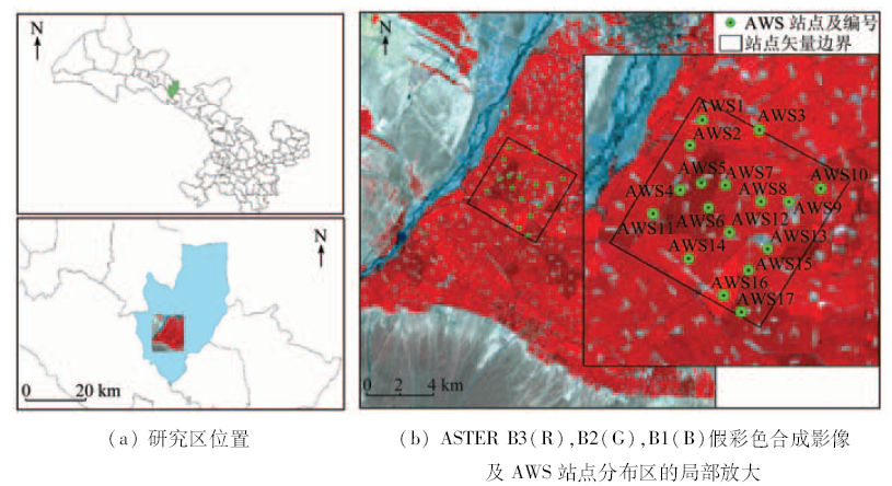
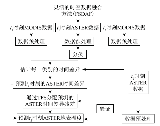
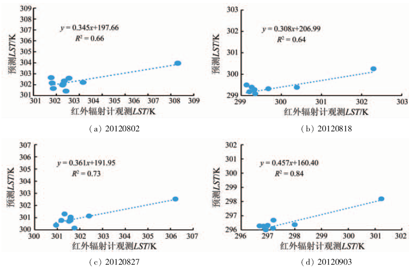
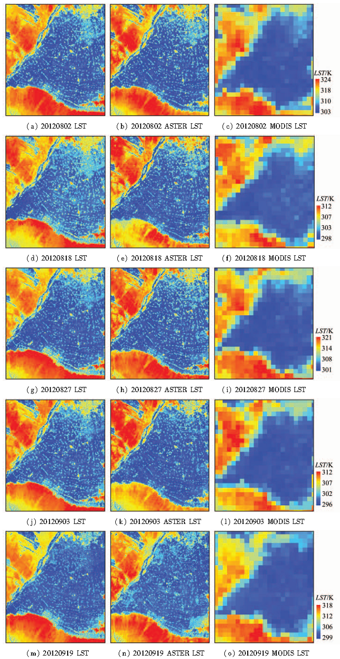
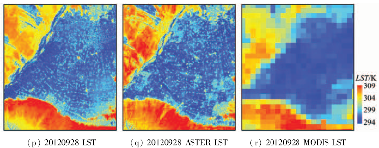
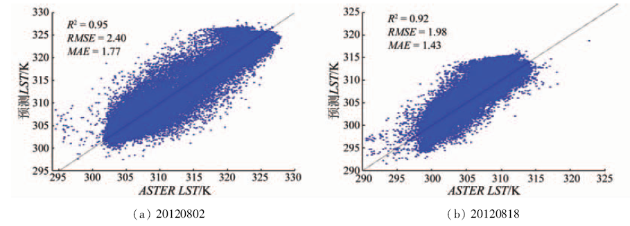
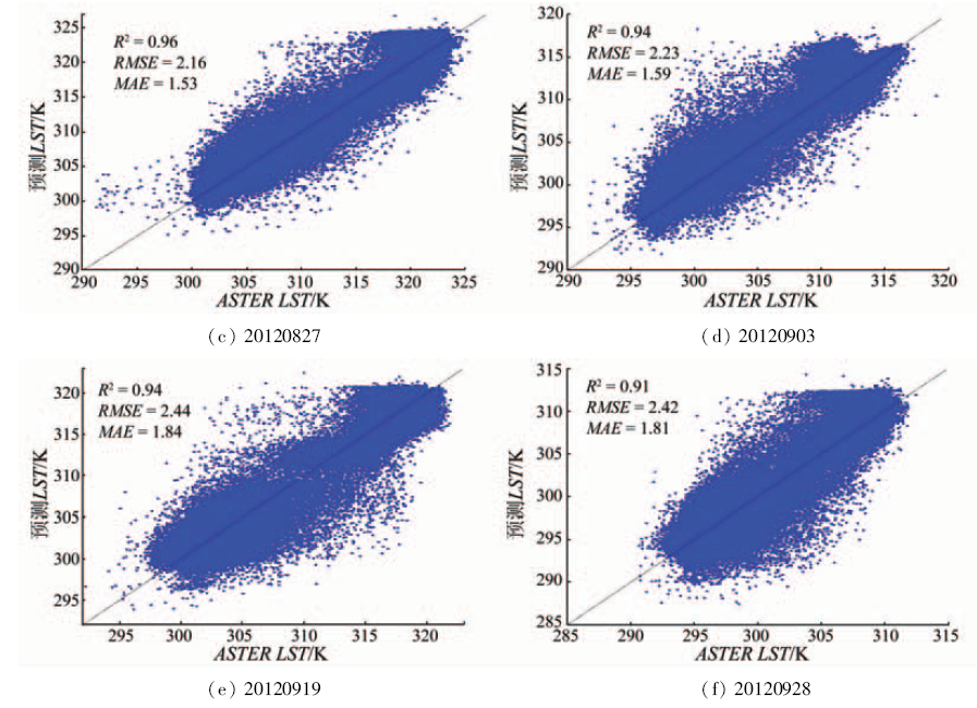
The application of the high spatio-temporal resolution data possesses very extensive foreground. Consequently, based on a flexible spatio-temporal data fusion(FSDAF)method and using MODIS and ASTER data,the authors generate the land surface temperature(LST) with high spatial and temporal resolution. FSDAF is a method based on spectral unmixing and thin plate spline interpolation function. Compared with the existing spatio-temporal data fusion method, its advantages lie in less input data,suitableness for heterogeneous surface and capability of predicting the gradient of land cover types and so on. The fusion results were verified by using the ASTER temperature products(7 days) and the surface radiation infrared temperature data(4 days)of the automatic weather station(AWS) sites. The results show that the LST images generated by the data fusion method based on FSDAF have higher clarity, the correlation coefficient of the fusion images and the ASTER LST products is higher than 0.91(September 28) , the room mean square error (RMSE) is less than 2.44 k(September 19), the mean absolute error (MAE) is less than 1.84 k (September 19)and the correlation coefficient of the fusion images and the AWS LST data R2 is higher than 0.64(August 18).
杨敏, 杨贵军, 陈晓宁, 张勇峰, 尤静妮. 基于FSDAF方法融合生成高时空分辨率地表温度[J]. 国土资源遥感, 2018, 30(1): 54-62.
Min YANG, Guijun YANG, Xiaoning CHEN, Yongfeng ZHANG, Jingni YOU. Generation of land surface temperature with high spatial and temporal resolution based on FSDAF method. Remote Sensing for Land & Resources, 2018, 30(1): 54-62.
Liu S M,Sun Z P,Li X W,et al.A comparative study on models for estimating evapotranspiration[J].Journal of Natural Resources,2003,18(2):161-167.
[2]
Li A N,Zhao W,Deng W.A quantitative inspection on spatio-temporal variation of remote sensing-based estimates of land surface evapotranspiration in south Asia[J].Remote Sensing,2015,7(4):4726-4752.
Zhang R H,Sun X M,Wang W M,et al.The physical basis of an operable regional scale surface fluxes on quantitative remote sensing Bilevel model[J].Science China Earth Sciences,2004,34(s2):200-216.
[4]
Huang B,Wang J,Song H H,et al.Generating high spatiotemporal resolution land surface temperature for urban heat island monitoring[J].IEEE Geoscience and Remote Sensing Letters,2013,10(5):1011-1015.
[5]
Zhou J,Zhan W F,Hu D Y,et al.Improvement of mono-window algorithm for retrieving land surface temperature from HJ-1B satellite data[J].Chinese Geographical Science,2010,20(2):123-131.
[6]
Wan Z M,Li Z L.A physics-based algorithm for retrieving land-surface emissivity and temperature from EOS/MODIS data[J].IEEE Transactions on Geoscience and Remote Sensing,1997,35(4):980-996.
Zhu X L,Helmer E H,Gao F,et al.A flexible spatiotemporal method for fusing satellite images with different resolutions[J].Remote Sensing of Environment,2016,172:165-177.
[9]
Gao F,Masek J,Schwaller M,et al.On the blending of the Landsat and MODIS surface reflectance:Predicting daily Landsat surface reflectance[J].IEEE Transactions on Geoscience and Remote Sensing,2006,44(8):2207-2218.
[10]
Zhu X L,Chen J,Gao F,et al.An enhanced spatial and temporal adaptive reflectance fusion model for complex heterogeneous regions[J].Remote Sensing of Environment,2010,114(11):2610-2623.
[11]
Hilker T,Wulder M A,Coops N C,et al.A new data fusion model for high spatial-and temporal-resolution mapping of forest disturbance based on Landsat and MODIS[J].Remote Sensing of Environment,2009,113(8):1613-1627.
[12]
Zhukov B,Oertel D,Lanzl F,et al.Unmixing-based multisensor multiresolution image fusion[J].IEEE Transactions on Geoscience and Remote Sensing,1999,37(3):1212-1226.
[13]
Wu M Q,Niu Z,Wang C Y,et al.Use of MODIS and Landsat time series data to generate high-resolution temporal synthetic Landsat data using a spatial and temporal reflectance fusion model[J].Journal of Applied Remote Sensing,2012,6(1): 063507.
[14]
Huang B,Song H H.Spatiotemporal reflectance fusion via sparse representation[J].IEEE Transactions on Geoscience and Remote Sensing,2012,50(10):3707-3716.
Jiao Y M,Ma M G,Xiao D N.Research on the landscape pattern of Zhangye oasis in the middle reaches of Heihe River[J].Journal of Glaciology and Geocryology,2003,25(1):94-99.
Liu R T,Li Y H,Xu P.Agricultural water saving task in Heihe River Basin and how to handle its relationship with other respects properly[J]. China Water Resources, 2002(2):44-46.
Li H,Wang H S,Du Y M, et al. HiWATER: ASTER LST and LSE dataset in 2012 in the middle reaches of the Heihe River Basin[EB/OL].2015. .
[18]
Li Z L,Tang B H,Wu H,et al.Satellite-derived land surface temperature:Current status and perspectives[J].Remote Sensing of Environment,2013,131:14-37.
[19]
Xu Z W,Liu S M,Li X,et al.Intercomparison of surface energy flux measurement systems used during the HiWATER-MUSOEXE[J].Journal of Geophysical Research:Atmospheres,2013,118(23):13140-13157.
[20]
Li H,Sun D L,Yu Y Y,et al.Evaluation of the VIIRS and MODIS LST products in an arid area of Northwest China[J].Remote Sensing of Environment,2014,142:111-121.
[21]
Yang G J,Weng Q H,Pu R L,et al.Evaluation of ASTER-like daily land surface temperature by fusing ASTER and MODIS data during the HiWATER-MUSOEXE[J].Remote Sensing,2016,8(1):75.
Bai J,Liu S M,Hu G.Inversion and verification of land surface temperature with remote sensing TM/ETM+ data[J].Transactions of the CSAE,2008,24(9):148-154.
Yang G J,Sun C H,Li H.Verification of high-resolution land surface temperature by blending ASTER and MODIS data in Heihe River Basin[J].Transactions of the Chinese Society of Agricultural Engineering,2015,31(6):193-200.
Yu W P,Ma M G.Validation of the MODIS land surface temperature products:A case study of the Heihe River Basin[J].Remote Sensing Technology and Application,2011,26(6):705-712.
[25]
Wan Z M.New refinements and validation of the MODIS Land-Surface Temperature/Emissivity products[J].Remote Sensing of Environment,2008,112(1):59-74.
Shi Y C,Yang G J,Li X C,et al.Intercomparison of the different fusion methods for generating high spatial-temporal resolution data[J].Journal of Infrared and Millimeter Waves,2015,34(1):92-99.
 2018, Vol. 30
  ), 杨贵军2,3,4(