Please wait a minute...
 
国土资源遥感  2021, Vol. 33 Issue (1): 158-166    DOI: 10.6046/gtzyyg.2020166
     技术应用 本期目录 | 过刊浏览 | 高级检索 |
基于TRMM数据与SPI指数的广西地区旱涝演变分析
晏红波1,2(), 韦晚秋1, 卢献健1,2(), 黄俞惠1
1.桂林理工大学测绘地理信息学院,桂林 541004
2.广西空间信息与测绘重点实验室,桂林 541004
A study of drought and flood evolution in Guangxi based on TRMM data and SPI drought index
YAN Hongbo1,2(), WEI Wanqiu1, LU Xianjian1,2(), HUANG Yuhui1
1. College of Geomatics and Geoinformation, Guilin University of Technology, Guilin 541004,China
2. Guangxi Laboratory of Spatial Information and Mapping, Guilin 541004, China
全文: PDF(4242 KB)   HTML  
输出: BibTeX | EndNote (RIS)      
摘要 

干旱是一种影响大、受灾重且恢复周期长的自然灾害,广西是农业大省,对广西地区进行干旱情况分析及预测对该地防灾减灾具有重要意义。通过对广西地区1998—2019年的降雨情况进行分析,并引入标准化降水指数(standardized precipitation index,SPI),验证了热带降雨测量卫星(tropical rainfall measuring mission,TRMM)数据在广西地区的适用性,研究了广西地区22 a间旱涝演变情况,并对未来广西地区旱涝变化趋势做出预测。结果表明: ①TRMM 3B43降雨数据与地面台站实测数据具有高度相关性,适用于广西地区的干旱监测; ②广西地区旱涝灾害频繁,平均每6 a就会有范围较大的洪涝事件发生; 每2~3 a 就会有范围较大的严重的干旱事件发生; ③广西地区夏季降雨量最大,冬季最小,且降雨总体呈现“东多西少”的格局; ④根据结果可以预测,2020年广西地区整体没有较大的干旱和洪涝事件发生,部分城市将会出现轻度洪涝和轻度干旱的情况。

服务
把本文推荐给朋友
加入引用管理器
E-mail Alert
RSS
作者相关文章
晏红波
韦晚秋
卢献健
黄俞惠
关键词 TRMM数据SPI干旱分析广西    
Abstract

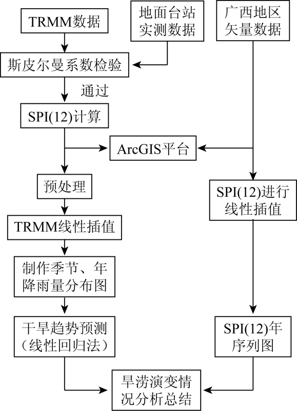
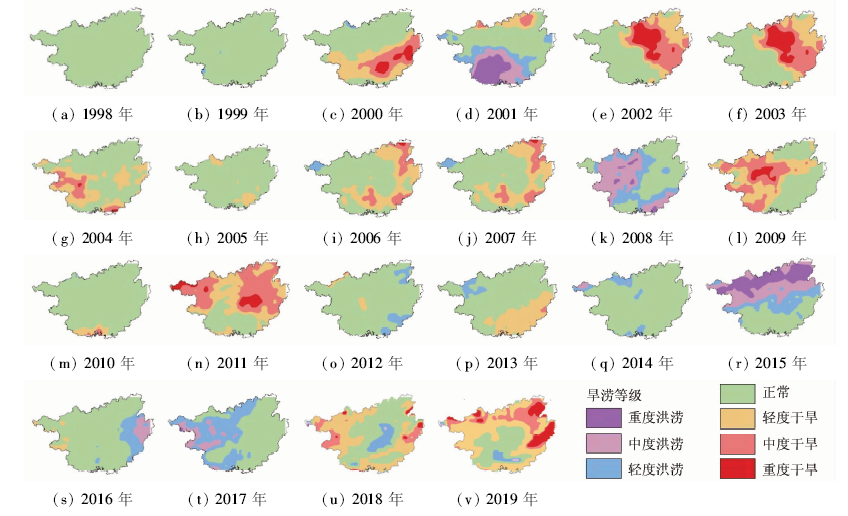
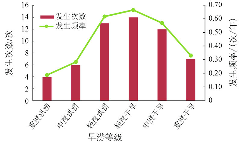
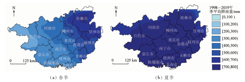
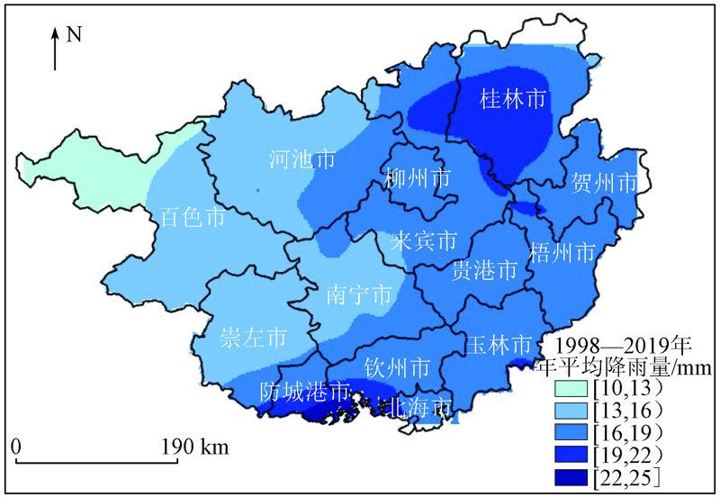
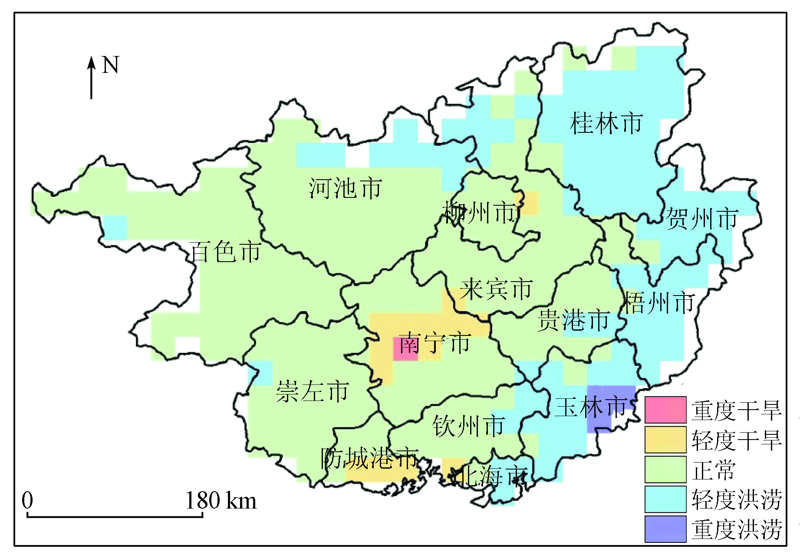
Drought is a kind of natural disaster with great influence, heavy disaster and long recovery period. As Guangxi is a large agricultural region, it is of great significance to analyze and forecast the drought situation in Guangxi for disaster prevention and mitigation. In this study, the authors analyzed the rainfall in Guangxi from 1998 to 2019, and introduced the standardized precipitation index (SPI) SPI drought index to verify the applicability of tropical rainfall measurement mission (TRMM) data in Guangxi. In addition, the evolution of drought in Guangxi in the past 22 years was studied, and the trend of drought change in Guangxi was predicted. The results are as follows: ① TRMM 3B43 rainfall data have a high correlation with the measured data of ground stations, which proves that TRMM3b43 rainfall data are suitable for drought monitoring in Guangxi. ② Drought and flood disasters occur frequently in Guangxi, with a large range of flood events every 6 years and serious drought events every 2~3 years. ③ The rainfall in Guangxi is the largest in summer and the smallest in winter, and the overall rainfall pattern is “more in the east and less in the west”. ④ It is estimated that there would be no major drought and flood events in Guangxi in 2020; nevertheless, some cities would have mild floods and mild droughts.

Key wordsTRMM data    SPI    drought analysis    Guangxi
收稿日期: 2020-06-11      出版日期: 2021-03-18
ZTFLH:  TP79  
基金资助:广西空间信息与测绘重点实验室主任基金项目“喀斯特地表土壤水分定量遥感反演中的关键问题研究”(15-140-07-17);“西南喀斯特地区地表关键要素定量遥感反演方法研究”共同资助(16-380-25-03)
通讯作者: 卢献健
作者简介: 晏红波(1983-)女,博士,副教授,主要从事遥感数据处理及其应用方面的研究。Email: 56403075@qq.com
引用本文:   
晏红波, 韦晚秋, 卢献健, 黄俞惠. 基于TRMM数据与SPI指数的广西地区旱涝演变分析[J]. 国土资源遥感, 2021, 33(1): 158-166.
YAN Hongbo, WEI Wanqiu, LU Xianjian, HUANG Yuhui. A study of drought and flood evolution in Guangxi based on TRMM data and SPI drought index. Remote Sensing for Land & Resources, 2021, 33(1): 158-166.
链接本文:  
https://www.gtzyyg.com/CN/10.6046/gtzyyg.2020166      或      https://www.gtzyyg.com/CN/Y2021/V33/I1/158
Fig.1  广西地理位置
Fig.2  数据处理流程
SPI范围 旱涝等级
≥2.0 重度洪涝
1.5≤SPI<2.0 中度洪涝
1.0≤SPI<1.5 轻度洪涝
-1.0≤SPI<1.0 正常
-1.5≤SPI<-1.0 轻度干旱
-2.0≤SPI<-1.5 中度干旱
<-2.0 重度干旱
Tab.1  SPI值对应旱涝等级
月份 斯皮尔曼相关系数 显著性水平
1月 0.944 <0.001
2月 0.918 <0.001
3月 0.892 <0.001
4月 0.888 <0.001
5月 0.821 <0.001
6月 0.852 <0.001
7月 0.894 <0.001
8月 0.864 <0.001
9月 0.889 <0.001
10月 0.931 <0.001
11月 0.936 <0.001
12月 0.919 <0.001
Tab.2  TRMM数据与地面台站数据相关性分析
Fig.3  由TRMM数据计算的1998—2019年SPI(12)分布
Fig.4  1998—2019年旱涝发生频率统计
Fig.5-1  由TRMM数据反演的广西1998—2019年四季平均降水量分布
Fig.5-2  由TRMM数据反演的广西1998—2019年四季平均降水量分布
Fig.6  由TRMM数据反演的广西1998—2019年平均降水量分布图
分级标准 变化程度 面积百分比/%
θSlope≤-0.01 重度干旱 0.3
-0.01<θSlope≤0 轻度干旱 5.0
0<θSlope≤0.005 正常 64.5
0.005≤<θSlope≤0.01 轻度洪涝 30.0
θSlope>0.01 重度洪涝 0.2
Tab.3  回归分析法广西降雨旱涝变化趋势
Fig.7  广西喀斯特区域分布
Fig.8  2020年广西旱涝趋势预测
[1] 袁文平, 周广胜. 干旱指标的理论分析与研究展望[J]. 地球科学进展, 2004,19(6):982-991.
Yuan W P, Zhou G S. Theoretical analysis and research prospect of drought index[J]. Progress in Geoscience, 2004,19(6):982-991.
[2] 李维京, 左金清, 宋艳玲, 等. 气候变暖背景下我国南方旱涝灾害时空格局变化[J]. 气象, 2015,41(3):261-271.
Li W J, Zuo J Q, Song Y L, et al. Temporal and spatial pattern changes of drought and flood disasters in South China under the background of climate warming[J]. Meteorology, 2015,41(3):261-271.
[3] 韩海涛, 胡文超, 陈学君, 等. 三种气象干旱指标的应用比较研究[J]. 干旱地区农业研究, 2009,27(1):237-241,247.
Han H T, Hu W C, Chen X J. Comparative study on the application of three meteorological drought indexes[J]. Agricultural Research in Arid Areas, 2009,27(1):237-241,247.
[4] 李锐, 傅云飞. GPCP和TRMM PR热带月平均降水的差异分析[J]. 气象学报, 2005,63(2):146-160.
Li R, Fu Y F. Analysis of the difference between GPCP and TRMM PR monthly mean precipitation in the tropics[J]. Journal of Meteorology, 2005,63(2):146-160.
[5] 自勇, 许吟隆, 傅云飞. GPCP与中国台站观测降水的气候特征比较[J]. 气象学报, 2007,65(1):63-74.
Zi Y, Xu Y L, Fu Y F. Comparison of climatic characteristics of precipitation observed by GPCP and China stations[J]. Journal of Meteorology, 2007,65(1):63-74.
[6] 李景刚, 阮宏勋, 李纪人, 等. TRMM降水数据在气象干旱监测中的应用研究[J]. 水文, 2010,30(4):43-46.
Li J G, Ruan H X, Li J R, et al. Application of TRMM precipitation data in meteorological drought monitoring[J]. Hydrology, 2010,30(4):43-46.
[7] 李燕, 周游游, 胡宝清, 等. 基于TRMM数据的广西西江流域降水时空分布特征[J]. 亚热带资源与环境学报, 2017,12(1):75-82.
Li Y, Zhou Y Y, Hu B Q, et al. Temporal and spatial distribution characteristics of precipitation in Xijiang River basin of Guangxi based on TRMM data[J]. Journal of Subtropical Resources and Environment, 2017,12(1):75-82
[8] 陈诚, 赵书河. 基于TRMM降雨数据的中国黄淮海地区干旱监测分析[J]. 国土资源遥感, 2016,28(1):122-129.doi: 10.6046/gtzyyg.2016.01.18.
Chen C, Zhao S H. Drought monitoring and analysis of Huanghuai Hai plain based on TRMM precipitation data[J]. Remote Sensing for Land and Resources, 2016,28(1):122-129.doi: 10.6046/gtzyyg.2016.01.18.
[9] 熊俊楠, 李伟, 刘志奇, 等. 基于GWR模型的青藏高原地区TRMM数据降尺度研究[J]. 国土资源遥感, 2019,31(4):88-95.doi: 10.6046/gtzyyg.2019.04.12.
Xiong J N, Li W, Liu Z Q, et al. Research on downscaling of TRMM data in the Tibetan Plateau based on GWR model[J]. Remote Sensing for Land and Resources, 2019,31(4):88-95.doi: 10.6046/gtzyyg.2019.04.12.
[10] Gupta A, Thapliyal P K, Pal P K. Identification of dry and wet soil conditions using TRMM/TMI brightness temperatures and potential for drought monitoring[J]. International Journal of Remote Sensing, 2007,28(6):1425-1431.
[11] Naumann G, Barbosa P, Carrao H, et al. Monitoring drought conditions and their uncertainties in Africa using TRMM data[J]. Journal of Applied Meteorology and Climatology, 2012,51(10):1867-1874.
[12] 白永清, 智协飞, 祁海霞, 等. 基于多尺度SPI的中国南方大旱监测[J]. 气象科学, 2010,30(3):292-300.
Bai Y Q, Zhi X F, Qi H X, et al. Drought monitoring in southern China based on multi-scale SPI[J]. Meteorological Science, 2010,30(3):292-300.
[13] 邵进, 李毅, 宋松柏. 基于SPI模型的江汉平原旱涝分布及其变化规律的研究[J]. 水文, 2012,32(2):34-39.
Shao J, Li Y, Song S B. Study on the distribution of drought and flood in Jianghan Plain based on SPI model[J]. Hydrology, 2012,32(2):34-39
[14] 王俊霞, 朱秀芳, 刘宪锋, 等. 基于多源遥感数据的旱情评价研究——以河南省为例[J]. 国土资源遥感, 2018,30(1):180-186.doi: 10.6046/gtzyyg.2018.01.25.
Wang J X, Zhu X F, Liu X F, et al. Research on agriculture drought monitoring method of Henan Province with multi-sources data[J]. Remote Sensing for Land and Resources, 2018,30(1):180-186.doi: 10.6046/gtzyyg.2018.01.25.
[15] 黄晚华, 杨晓光, 李茂松, 等. 基于标准化降水指数的中国南方季节性干旱近58 a演变特征[J]. 农业工程学报, 2010,26(7):50-59.
Huang W H, Yang X G, Li M S, et al. Evolution characteristics of seasonal drought in South China in recent 58 years based on standardized precipitation index[J]. Journal of Agricultural Engineering, 2010,26(7):50-59.
[16] 吴健, 周秋文, 韦小茶, 等. TRMM降水产品在喀斯特地区的空间降尺度研究——以贵州省为例[J]. 人民珠江, 2019,40(6):20-26.
Wu J, Zhou Q W, Wei X C, et al. Study on the spatial downscaling of TRMM precipitation products in karst area:A case study of Guizhou Province[J]. Pearl River, 2019,40(6):20-26.
[17] 赵耀军. 时间序列分析[J]. 山西冶金, 2012,35(6):56-58.
Zhao Y J. Time series analysis[J]. Shanxi Metallurgy, 2012,35(6):56-58.
[18] 高桂霞, 许明丽, 唐继业. 干旱指标及等级划分方法研究[J]. 安徽农业科学, 2011,39(9):5301-5305.
Gao G X, Xu M L, Tang J Y. Study on drought index and classification method[J]. Anhui Agricultural Science, 2011,39(9):5301-5305.
[19] 广西壮族自治区气象局. 广西气候公报2013-2019[EB/OL].[2020-06-11]. http://gx.cma.gov.cn/qxfw/qxgb/.
Guangxi Zhuang Autonomous Region Meteorological Bureau. Guangxi climate bulletin 2013-2019[EB/OL].[2020-06-11]. http://gx.cma.gov.cn/qxfw/qxgb/.
[20] 广西壮族自治区水利厅. 广西水资源公报2008-2018[EB/OL].[2020-06-11]. http://slt.gxzf.gov.cn/zwgk/jbgb/gxszygb/.
Department of Water Resources of Guangxi Zhuang Autonomous Region. Guangxi water resources bulletin[EB/OL].[2020-06-11]. http://slt.gxzf.gov.cn/zwgk/jbgb/gxszygb/.
[21] 广西气象信息服务站. 广西气候概况[EB/OL].(2006-11) http://www.gx121.com/gx_climate_info.asp.
Guangxi Meteorological Information Service Station. General situation of climate in Guangxi[EB/OL].(2006-11) http://www.gx121.com/gx_climate_info.asp.
[22] 覃志年, 唐炳莉. 2003年夏—2004年冬广西的旱灾及其防御对策[J]. 灾害学, 2004,19(9):29-33.
Qin Z N, Tang B L. Drought in Guangxi from summer 2003 to winter 2004 and its countermeasures[J]. Disaster Science, 2004,19(9):29-33.
[1] 钞振华, 车明亮, 侯胜芳. 基于时间序列遥感数据植被物候信息提取软件发展现状[J]. 自然资源遥感, 2021, 33(4): 19-25.
[2] 黄景金, 唐长增, 李毅, 左天惠, 杨郑贝. 广西自然资源调查监测体系构建[J]. 国土资源遥感, 2020, 32(2): 154-161.
[3] 陈华, 宋志宏, 王永江. 特殊地质地貌条件对水蚀型荒漠化的影响分析—以广西壮族自治区为例[J]. 国土资源遥感, 2010, 22(s1): 169-173.
[4] 陈凌云, 胡自宁, 黎广钊, 钟仕全, 石剑龙. 遥感技术在广西海岛调查中的应用[J]. 国土资源遥感, 2005, 17(4): 78-81.
Viewed
Full text


Abstract

Cited

  Shared   
  Discussed   
京ICP备05055290号-2
版权所有 © 2015 《自然资源遥感》编辑部
地址:北京学院路31号中国国土资源航空物探遥感中心 邮编:100083
电话:010-62060291/62060292 E-mail:zrzyyg@163.com
本系统由北京玛格泰克科技发展有限公司设计开发