1. State Key Laboratory of Information Engineering in Surveying, Mapping and Remote Sensing, Wuhan University, Wuhan 430079,China 2. China Aero Geophysical Survey and Remote Sensing Center for Natural Resources, Beijing 100083, China 3. China National Administration of GNSS and Applications, Beijing 100088, China 4. Institute of Geospatial Information, Strategic Support Force Information Engineering University, Zhengzhou 450001, China
In the context of the growing maturity of on-road navigation, this study proposed a cross-disciplinary research direction-off-road navigation-based on the demands for navigation services in complex and unstructured environments. First, the development of on-road navigation and the demand scenarios of off-road navigation were introduced. Based on four specific aspects of vehicle trafficability, scientific issues in the transition from on-road to off-road navigation were presented, including refining remote sensing detection of geographical and geological trafficability elements, remote sensing-based retrieval of soft soil parameters in off-road areas, and quantitative mechanisms behind the impacts of climatic change on ground characteristics. Accordingly, the research direction of off-road navigation was clarified. Then, key technologies like vehicle trafficability calculation and characterization, digital road network construction in off-road areas, and intelligent path planning for off-road navigation were summarized. The technical approach of roadization for off-road areas and the concept of a digital road network for off-road areas were introduced, followed by the establishment of a comprehensive technology system for off-road navigation. Finally, in combination with practical applications, the potential of off-road navigation was confirmed. Research on off-road navigation will further enrich the connotation of navigation and expand its application boundaries.
Wang Z Z. Looking forward to the development prospect of Surveying and Mapping—Commemorating the 30th anniversary of the publication of Journal of Surveying and Mapping[J]. Acta Geodaetica et Cartographic Sinica, 1987, 16(2):83-85.
Li D R, Hong Y, Wang M, et al. What can surveying and remote sensing do for intelligent driving?[J]. Acta Geodaetica et Cartographica Sinica, 2021, 50(11):1421-1431.
doi: 10.11947/j.AGCS.2021.20210280
[3]
Liu R, Wang J, Zhang B. High definition map for automated driving:Overview and analysis[J]. Journal of Navigation, 2020, 73(2):324-341.
Yu Z Y, lyu G N, Zhang X N, et al. Pan-information-based high precision navigation map:Concept and theoretical model[J]. Journal of Geo-Information Science, 2020, 22(4):760-771.
Zhang P, Liu J N. A generalized data model of high definition maps[J]. Acta Geodaetica et Cartographica Sinica, 2021, 50(11):1432-1446.
doi: 10.11947/j.AGCS.2021.20210254
[6]
Ibisch P L, Hoffmann M T, Kreft S, et al. A global map of roadless areas and their conservation status[J]. Science, 2016, 354(6318):1423-1427.
pmid: 27980208
[7]
Jayakumar P, Gorsich D, Hudson C, et al. Quantitative assessment of modelling and simulation tools for autonomous navigation of military vehicles over off-road terrains[J]. International Journal of Vehicle Performance, 2020, 6(3):327.
[8]
于海波, 吴必虎. 国外自驾游研究进展[J]. 旅游学刊, 2011, 26(3):55-61.
Yu H B, Wu B H. Progress about the study of overseas self-driving travel[J]. Tourism Tribune, 2011, 26(3):55-61.
[9]
Ort T, Paull L, Rus D. Autonomous vehicle navigation in rural environments without detailed prior maps[C]// 2018 IEEE International Conference on Robotics and Automation (ICRA).Brisbane,QLD,Australia.IEEE, 2018:2040-2047.
Diao Z X, Yu J X. Mobility grade and model of military vehicles[J]. Automotive Engineering, 2005, 27(3):354-357.
[11]
余志生. 汽车理论[M]. 北京: 机械工业出版社, 2019.
Yu Z S. Automobile theory[M]. Beijing: China Machine Press, 2019.
[12]
Rada J, Rybansky M, Dohnal F. The impact of the accuracy of terrain surface data on the navigation of off-road vehicles[J]. ISPRS International Journal of Geo-Information, 2021, 10(3):106.
Sun A, Yang Q H, Liu Z, et al. Transportation in the Siliguri Corridor,West Bengal,India:Distribution characteristics,trafficability,and geological environment[J]. Remote Sensing for Natural Resources, 2021, 33(3):138-147.doi:10.6046/zrzyyg.2020421.
Li D R, Zhang G, Jiang Y H, et al. Opportunities and challenges of geo-spatial information science from the perspective of big data[J]. Big Data Research, 2022, 8(2):3-14.
Feng Q L, Niu B W, Zhu D H, et al. Review for deep learning in land use and land cover remote sensing classification[J]. Transactions of the Chinese Society for Agricultural Machinery, 2022, 53(3):1-17.
Kang J J, Qi H P, Yang Q H, et al. Study of remote sensing detection method for road obstacle and accessibility evaluation[J]. Remote Sensing for Land and Resources, 2020, 32(2):94-102.doi:10.6046/gtzyyg.2020.02.13.
Zheng X W, Peng B, Shang K. Assessment of the interpretation ability of domestic satellites in geological remote sensing[J]. Remote Sensing for Natural Resources, 2021, 33(3):1-10.doi:10.6046/zrzyyg.2020357.
Liang X Y, Wang J L, Li P F, et al. GF-1 images-based information extraction of natural roads in arid and semi-arid regions of the Mongolian Plateau:A case study of Gurvantes Soum,Mongolia[J]. Remote Sensing for Natural Resources, 2023, 35(2):122-131.doi:10.6046/zrzyyg.2022117.
Chen F Q, Liu Y L, Gao X, et al. Application of remote sensing technology to the engineering geological survey for the construction of the China-Nepal railway[J]. Remote Sensing for Natural Resources, 2021, 33(4):219-226.doi:10.6046/zrzyyg.2020403.
Xin R F, Li Z R, Zhang K, et al. Remote sensing monitoring of the dynamic changes in geologic hazards in the Huangshui River Basin of Qinghai Province[J]. Remote Sensing for Natural Resources, 2022, 34(4):254-261.doi:10.6046/zrzyyg.2021313.
Wang X, Fan X M, Yang F, et al. Remote sensing interpretation method of geological hazards in lush mountainous area[J]. Geomatics and Information Science of Wuhan University, 2020, 45(11):1771-1781.
[22]
Wong J Y. Theory of ground vehicles[M]. Hoboken: Wiley, 2022.
Li K W, You X, Zhang X, et al. Evaluation of soil trafficability based on multi-source data[J]. Journal of Geomatics Science and Technology, 2018, 35(2):206-210.
Ai L, Sun S Y, Li S G, et al. Research progress on the cooperative inversion of soil moisture using optical and SAR remote sensing[J]. Remote Sensing for Natural Resources, 2021, 33(4):10-18.doi:10.6046/zrzyyg.2020416.
[25]
Ewing J, Oommen T, Jayakumar P, et al. Utilizing hyperspectral remote sensing for soil gradation[J]. Remote Sensing, 2020, 12(20):3312.
[26]
Bousbih S, Zribi M, Pelletier C, et al. Soil texture estimation using radar and optical data from sentinel-1 and sentinel-2[J]. Remote Sensing, 2019, 11(13):1520.
Jiang L M, Cui H Z, Wang G X, et al. Progress on remote sensing of snow,surface soil frozen/thaw state and soil moisture[J]. Remote Sensing Technology and Application, 2020, 35(6):1237-1262.
[28]
Zhang T, Barry R G, Knowles K, et al. Statistics and characteristics of permafrost and ground-ice distribution in the Northern Hemisphere[J]. Polar Geography, 2008, 31(1/2):47-68.
Yao Y, Wang B, Gao Z. Mechanism analysis and modeling of track-soil coupling system[J]. Journal of Changchun University of Technology, 2018, 39(6):528-533,633.
[30]
陈鼎. 基于地面分形特性的轮地相互作用机理研究及其应用[D]. 厦门: 厦门大学, 2019.
Chen D. Research and application of tire-soil interaction mechanism based on soil fractal characteristics[D]. Xiamen: Xiamen University, 2019.
Hua C, Niu R X, Yu B. Methods and applications of ground vehicle mobility evaluation[J]. Journal of Jilin University (Engineering and Technology Edition), 2022, 52(6):1229-1244.
Shao Y, Zhang M, Xie C. Present situation and prospect of comprehensive monitoring in geological hazard by remote sensing[J]. Geology and Resources, 2022, 31(3):381-394.
Xu Q. Understanding and consideration of related issues in early identification of potential geohazards[J]. Geomatics and Information Science of Wuhan University, 2020, 45(11):1651-1659.
Gao Y J, Li G Y, Lyu Z W. Current situation and prospect of satellite navigation interference technology[J]. Geomatics & Spatial Information Technology, 2022, 45(6):13-18.
Wang J, Guo Y, Tang K H, et al. Development trend of spoofing jamming technology for satellite navigation[J]. Navigation and Control, 2022, 21(1):13-24.
doi: 10.3969/j.issn.1674-5558.2022.01.002
Huang L, Tang X M, Wang F X. Anti-spoofing techniques for GNSS receiver[J]. Geomatics and Information Science of Wuhan University, 2011, 36(11):1344-1347.
[37]
Babapour R, Naghdi R, Ghajar I, et al. Forest road profile optimization using meta-heuristic techniques[J]. Applied Soft Computing, 2018, 64:126-137.
[38]
Casal G, Santamarina D, Vázquez-Méndez M E. Optimization of horizontal alignment geometry in road design and reconstruction[J]. Transportation Research Part C:Emerging Technologies, 2017, 74:261-274.
[39]
Park J, Abdel-Aty M. Safety performance of combinations of traffic and roadway cross-sectional design elements at straight and curved segments[J]. Journal of Transportation Engineering,Part A:Systems, 2017, 143(6):04017015.
Huo F C, Chi J, Huang Z J, et al. Review of path planning for mobile robots[J]. Journal of Jilin University (Information Science Edition), 2018, 36(6):639-647.
Yan J J, Zhang Q S, Hu X P. Review of path planning techniques based on reinforcement learning[J]. Computer Engineering, 2021, 47(10):16-25.
doi: 10.19678/j.issn.1000-3428.0060683
[43]
Cook J T, Ray L E, Lever J H. Dynamics modeling and robotic-assist,leader-follower control of tractor convoys[J]. Journal of Terramechanics, 2018, 75:57-72.
[44]
Godoy J, Artuñedo A, Beteta M, et al. Corridors-based navigation for automated vehicles convoy in off-road environments[J]. IFAC-PapersOnLine, 2022, 55(14):71-76.
[45]
Mao W, Liu Z, Liu H, et al. Research progress on synergistic technologies of agricultural multi-robots[J]. Applied Sciences, 2021, 11(4):1448.
[46]
Haley P W, Jurkat M P, Brady Jr P M, et al. NATO reference mobility model,Edition 1,Users guide.Volume 2.Obstacle Module[R].(1979).
[47]
Bradbury M, Dasch J, Gonzalez R, et al. Next-generation NATO reference mobility model (NG-NRMM)[J]. Tank Automotive Research,Development and Engineering Center (TARDEC),Warren,MI, 2016.
[48]
Wong J Y, Jayakumar P, Toma E, et al. A review of mobility metrics for next generation vehicle mobility models[J]. Journal of Terramechanics, 2020, 87:11-20.
doi: 10.1016/j.jterra.2019.10.003
[49]
McCullough M, Jayakumar P, Dasch J, et al. The Next Generation NATO Reference mobility model development[J]. Journal of Terramechanics, 2017, 73:49-60.
[50]
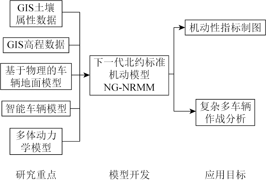
Wasfy T, Jayakumar P. Next-generation NATO reference mobility model complex terramechanics-part 1:Definition and literature review[J]. Journal of Terramechanics, 2021, 96:45-57.
 2024, Vol. 36
  ), 秦绪文2, 朱春阳1(