Ecological evolution of coal resource-based regions: A case study of Shanxi Province
LAI Shijiu1(), HU Jinshan1(), KANG Jianrong1, WANG Xiaobing2
1. School of Geography, Geomatics and Planning, Jiangsu Normal University, Xuzhou 221116, China 2. Sinosteel Maanshan General Institute of Mining Research Co.,Ltd., Maanshan 243000, China
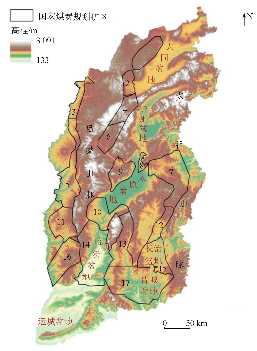
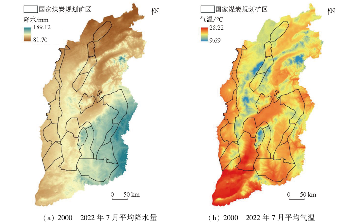
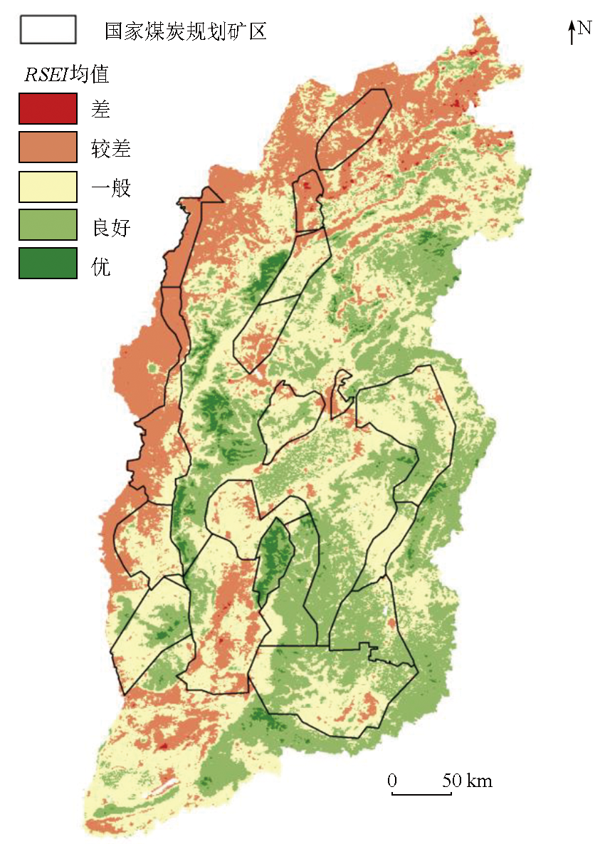
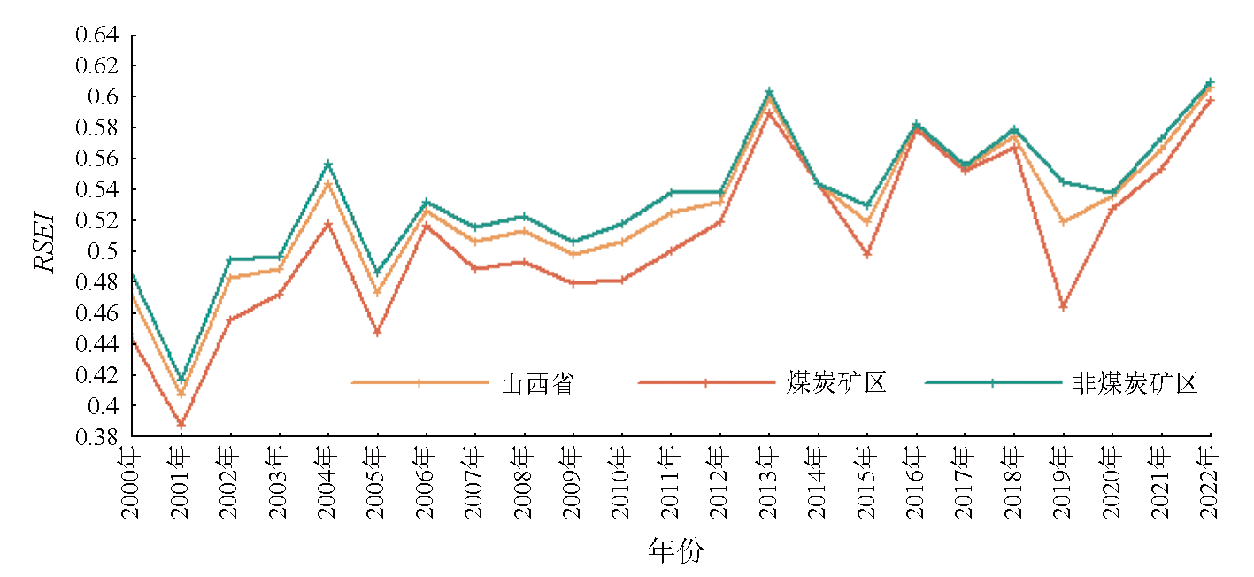
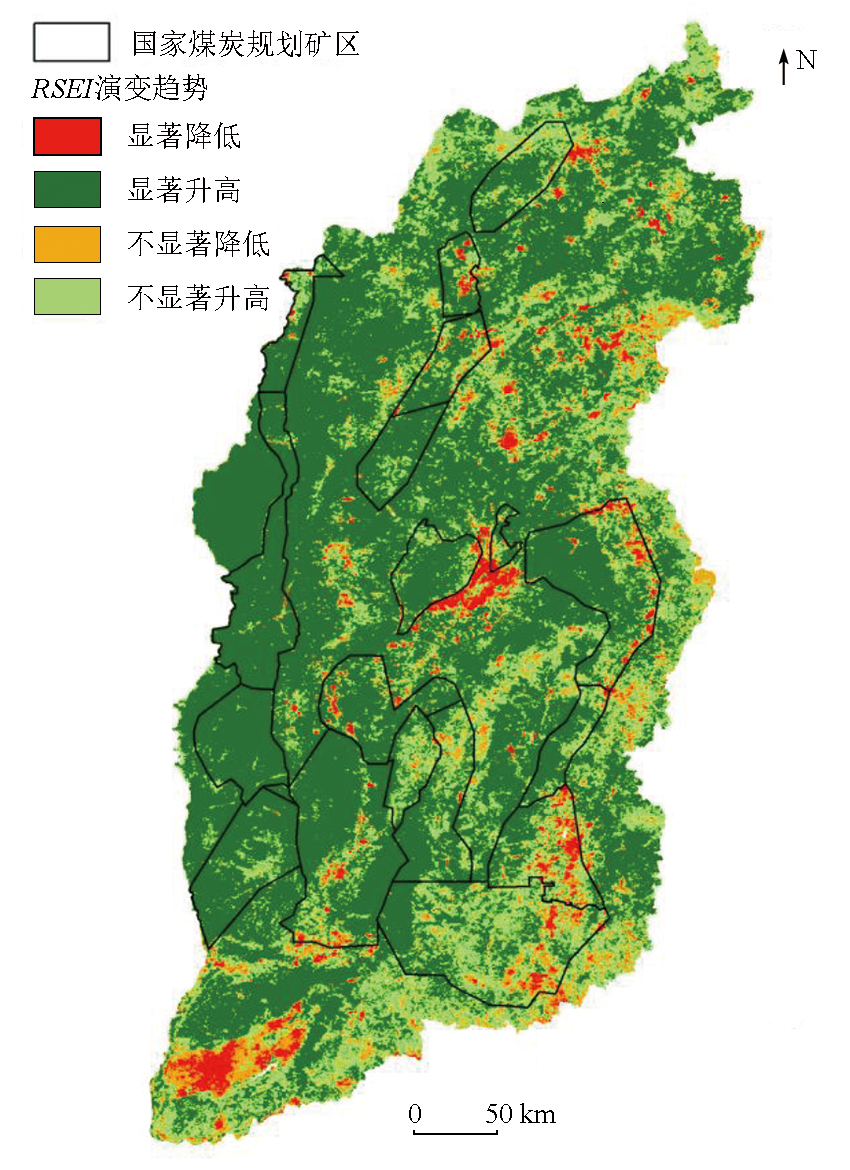
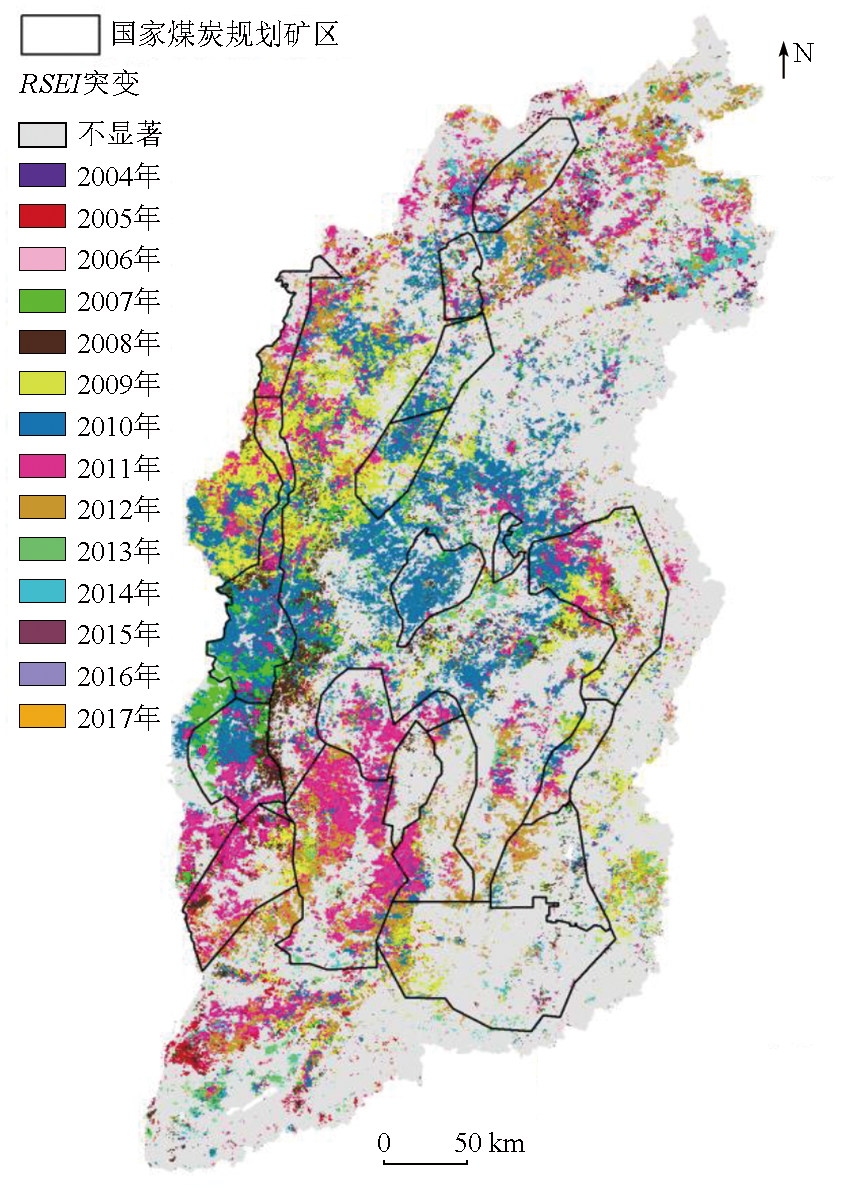
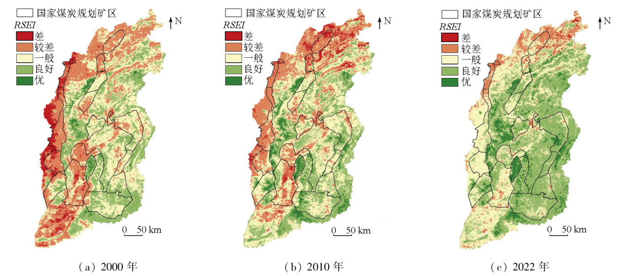
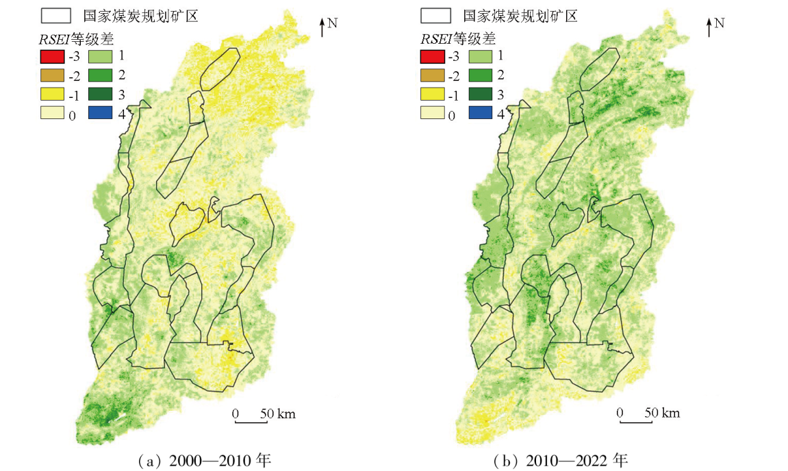
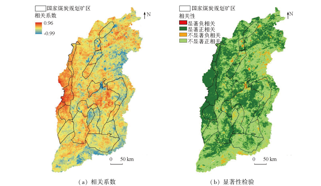
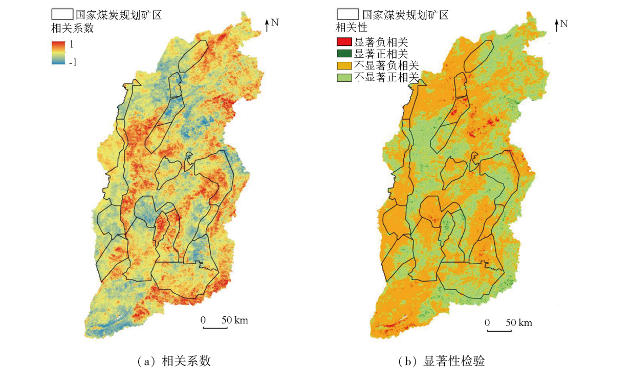
Shanxi Province is recognized as a significant coal base in China. The extensive and intensive coal mining activities have adversely affected the local ecology, rendering the research on ecological evolution in Shanxi Province highly significant. Utilizing the Google Earth Engine (GEE) platform, this study calculated the 2000-2022 remote sensing ecological index (RSEI) of Shanxi Province using images from Moderate Resolution Imaging Spectroradiometer (MODIS). The Mann-Kendall trend analysis method was employed to analyze the evolutionary trends of RSEI, while Pettitt mutation tests were conducted to identify RSEI mutations. Furthermore, the Pearson correlation coefficient was used to analyze the correlation between RSEI and climatic factors. The results indicate that Shanxi Province exhibited relatively high ecological quality on average during the period. However, the coal mining areas in the province displayed moderate ecological quality overall. The spatial distribution of precipitation and temperature can effectively account for the spatial distribution of RSEI. Most regions in Shanxi Province showed an upward trend in RSEI, with areas with reduced RSEI predominantly located in coal mining areas and basin areas with high population density and a developed economy. During the 23 years, the ecological quality in Shanxi Province has evolved from poor to moderate and then to relatively good, increased while fluctuating from 2000 to 2006, kept stable from 2006 to 2012, regressed after increase from 2012 to 2019, and continuously increased from 2019 to 2022. Similarly, the ecological quality in coal mining areas has shifted from relatively poor to relatively good, increased while fluctuating from 2000 to 2006, kept stable from 2006 to 2012, decreased while fluctuating from 2012 to 2019, and continuously increased from 2019 to 2022. The year 2010 is identified as a pivotal point for the ecological quality of Shanxi Province, with the ecological quality trending upward from 2000 to 2010 and comprehensively improving after 2010 across the province and its coal mining areas. The interannual variations in precipitation generally produce positive impacts on the ecological quality, while the variations in interannual temperature exert insignificant impacts.
赖仕久, 胡晋山, 康建荣, 王小兵. 煤炭资源型区域生态环境演变研究——以山西省为例[J]. 自然资源遥感, 2024, 36(4): 62-74.
LAI Shijiu, HU Jinshan, KANG Jianrong, WANG Xiaobing. Ecological evolution of coal resource-based regions: A case study of Shanxi Province. Remote Sensing for Natural Resources, 2024, 36(4): 62-74.
Fan D Q, Qiu Y, Sun W B, et al. Evaluating ecological environment based on remote sensing ecological index in Shenfu mining area[J]. Bulletin of Surveying and Mapping, 2021(7):23-28.
doi: 10.13474/j.cnki.11-2246.2021.0203
Li J, Li S C, Guo W, et al. Ecological environment analysis of Shanxi Province and coal mining areas based on modified remote sensing ecological index[J]. Metal Mine, 2023(1):30-39.
Lin N, Zhang D, Pan J P, et al. Long time series ecological quality assessment and influencing factors analysis in Changshou District[J]. Journal of Yangtze River Scientific Research Institute, 202, 40(11):56-62.
[6]
Hu X S, Xu H Q. A new remote sensing index for assessing the spatial heterogeneity in urban ecological quality:A case from Fuzhou City,China[J]. Ecological Indicators, 2018, 89:11-21.
[7]
Xu H Q, Wang Y F, Guan H D, et al. Detecting ecological changes with a remote sensing based ecological index (RSEI) produced time series and change vector analysis[J]. Remote Sensing, 2019, 11(20):2345.
Su J L, Yan C R, Lei Y, et al. Long time series dynamic monitoring of eco-environmental quality in Shaanxi Province[J]. Acta Ecologica Sinica, 2023, 43(2):554-568.
[37]
Yang H H, Yu J, Xu W Z, et al. Long-time series ecological environment quality monitoring and cause analysis in the Dianchi Lake Basin,China[J]. Ecological Indicators, 2023, 148:110084.
Zhong X C, Xu Q L. Monitoring and evaluation of ecological environment changes in Yuxi City based on RSEI model[J]. Research of Soil and Water Conservation, 2021, 28(4):350-357.
Pariha H, Zan M, Alimjan K. Remote sensing evaluation of ecological environment in Urumqi City and analysis of driving factors[J]. Arid Zone Research, 2021, 38(5):1484-1496.
doi: 10.13866/j.azr.2021.05.31
Li Y, Zhang G Q, Lin T, et al. The spatiotemporal changes of remote sensing ecological index in towns and the influencing factors:A case study of Jizhou District,Tianjin[J]. Acta Ecologica Sinica, 2022, 42(2):474-486.
Wen X L, Chen X, Xu H Q. Ecological evaluation of cities in southern Beijing suburbs based on remote sensing ecological index:Taking Zhuozhou City and Gu’an County as examples[J]. Journal of Fuzhou University (Natural Science Edition), 2022, 50(2):286-292.
Pan H Y, Li J A, Zhang Q. Study on restoration of ecological environment quality in earthquake area based on RSEI:A case study of Wenchuan County[J]. Resources and Environment in the Yangtze Basin, 2021, 30(3):745-757.
Wang J, Zhao M D, Li J B, et al. Dynamic monitoring and driving forces of eco-environmental quality in the qinba mountains based on MODIS time-series data[J]. Mountain Research, 2021, 39(6):830-841.
Zhang Y X, Wang S M, Li Y, et al. Spatiotemporal patterns of ecological quality across the Qinghai-Tibet Plateau during 2000-2020[J]. Chinese Journal of Ecology, 2023, 42(6):1464-1473.
doi: DOI: 10.13292/j.1000-4890.202306.033
[16]
Yuan B D, Fu L, Zou Y A, et al. Spatiotemporal change detection of ecological quality and the associated affecting factors in Dongting Lake Basin,based on RSEI[J]. Journal of Cleaner Production, 2021, 302:126995.
[17]
Xiong Y, Xu W H, Lu N, et al. Assessment of spatial-temporal changes of ecological environment quality based on RSEI and GEE:A case study in Erhai Lake Basin,Yunnan Province,China[J]. Ecological Indicators, 2021, 125:107518.
Li J, Hao Y H, Sun J M, et al. Evaluation of ecological environment’ spatio-temporal variation in urban mine based on rsei[J]. Urban Development Studies, 2021, 28(1):17-22.
Kang S Z, Mu Q, Zhao Y H, et al. Temporal and spatial pattern characteristics of ecological environmental quality in Shenfu mining area of Loess Plateau[J]. Acta Ecologica Sinica, 2023, 43(7):2781-2792.
Fu J, Wang P, Zhang Q, et al. Dynamic monitoring of ecological environment quality of Hainan Island based on improved remote sensing ecological index[J]. Journal of Agricultural Resources and Environment, 2021, 38(6):1102-1111.
Zhang W, Du P J, Guo S C, et al. Enhanced remote sensing ecological index and ecological environment evaluation in arid area[J]. National Remote Sensing Bulletin, 2023, 27(2):299-317.
[22]
Firozjaei M K, Fathololoumi S, Weng Q H, et al. Remotely sensed urban surface ecological index (RSUSEI):An analytical framework for assessing the surface ecological status in urban environments[J]. Remote Sensing, 2020, 12(12):2029.
Zhu D Y, Chen T, Niu R Q, et al. Analyzing the ecological environment of mining area by using moving window remote sensing ecological index[J]. Geomatics and Information Science of Wuhan University, 2021, 46(3):341-347.
[24]
Zhu D Y, Chen T, Wang Z W, et al. Detecting ecological spatial-temporal changes by remote sensing ecological index with local adaptability[J]. Journal of Environmental Management, 2021, 299:113655.
Xu H Q, Li C Q, Lin M J. Should RSEI use PCA or kPCA?[J]. Geomatics and Information Science of Wuhan University, 2023, 48(4):506-513.
[27]
Zheng Z H, Wu Z F, Chen Y B, et al. Instability of remote sensing based ecological index (RSEI) and its improvement for time series analysis[J]. Science of the Total Environment, 2022, 814:152595.
[28]
Xu H Q, Li C Q, Shi T T. Is the z-score standardized RSEI suitable for time-series ecological change detection? Comment on Zheng et Al.(2022)[J]. The Science of the Total Environment, 2022, 853:158582.
[29]
Zheng Z H, Wu Z F, Marinello F. Response to the letter to the editor" Is the z-score standardized RSEI suitable for time-series ecological change detection? Comment on Zheng et al.(2022)"[J]. Science of the Total Environment, 2023, 855:158932.
[30]
Xu H, Liu F, Li C. Can a model be evaluated by a single fictitious data point in a real-world study case? Further comments on Zheng et al.[J]. Science of the Total Environment, 2023, 858:159911.
Niu C H, Zhang M, Fan Y P. The influence evaluation of ecological environment caused by coal mining of Shanxi[J]. Journal of Taiyuan University of Technology, 2006, 37(6):649-653.
Xu H Q. A study on information extraction of water body with the modified normalized difference water index (MNDWI)[J]. Journal of Remote Sensing, 2005, 9(5):589-595.
[33]
Cao J X, Wu E T, Wu S H, et al. Spatiotemporal dynamics of ecological condition in qinghai-tibet plateau based on remotely sensed ecological index[J]. Remote Sensing, 2022, 14(17):4234.
[34]
Fu J, Gong Y Q, Zheng W W, et al. Spatial-temporal variations of terrestrial evapotranspiration across China from 2000 to 2019[J]. Science of the Total Environment, 2022, 825:153951.
Yao T C, Lu H W, Yu Q, et al. Potential evapotranspiration characteristic and its abrupt change across the qinghai-tibetan plateau and its surrounding areas in the last 50 years[J]. Advances in Earth Science, 2020, 35(5):534-546.
[36]
Feng Q, Zhou Z F, Zhu C L, et al. Quantifying the ecological effectiveness of poverty alleviation relocation in Karst areas[J]. Remote Sensing, 2022, 14(23):5920.
 2024, Vol. 36
  ), 胡晋山1(