Relationship of air temperature to NDVI and NDBI in Guangzhou City using spatial autoregressive model
Jianhui XU1,2,3(), Yi ZHAO4,5, Minghong XIAO6, Kaiwen ZHONG1,2,3, Huihua RUAN7
1. Guangzhou Institute of Geography, Guangzhou 510070, China 2. Key Laboratory of Guangdong for Utilization of Remote Sensing and Geographical Information System, Guangzhou 510070, China 3. Guangdong Open Laboratory of Geospatial Information Technology and Application, Guangzhou 510070, China 4. Guangzhou Institute of Geochemistry, China Academy of Sciences, Guangzhou 510640, China 5. University of Chinese Academy of Sciences, Beijing 100049, China 6. Guangxi Institute of Geographic Information Surveying and Mapping, Liuzhou 545006, China 7. Guangdong Meteorological Observation Data Center, Guangzhou 510080, China
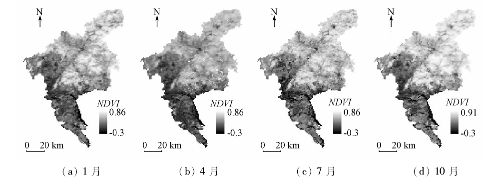
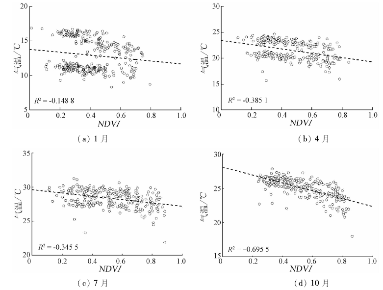
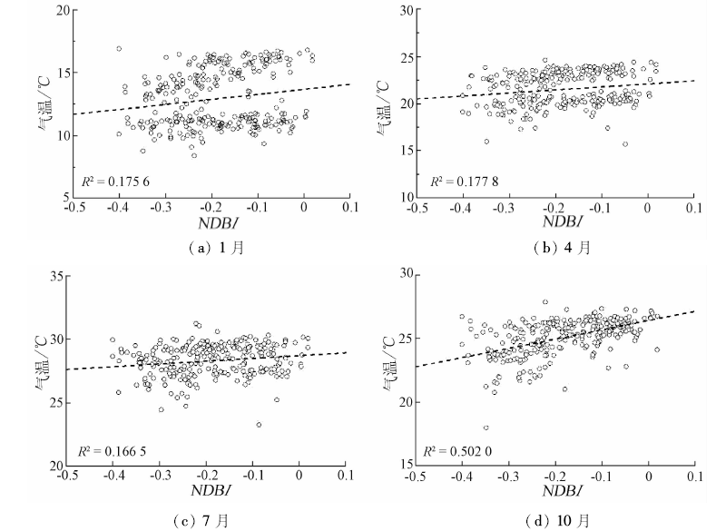
To study the spatio-temporal pattern of the air temperature in Guangzhou City, the authors used MODIS monthly normalized difference vegetation index (NDVI) acquired in 2015 and extracted the normalized difference built-up index (NDBI) with Landsat8 OLI data. The correlation analysis method was used to explore the relationship between air temperature and NDVI, NDBI. The experimental results show that there is a negative relation between NDVI and air temperature and a positive relation between NDBI and air temperature. On such a basis, the spatial lag model (SLM) and spatial error model (SEM) were established to discuss the spatial relations between air temperature and NDVI, NDBI in different seasons, respectively. The SLM and SEM results were compared with the ordinary least square regression (OLS) model, which shows the best performance of the SLM and SEM models. The SLM model with higher R2 and lower AIC values performs slightly better than the SEM model. NDVI has more influence on air temperature from spring to autumn than NDBI. In the SLM model, the positive and significant spatial autoregressive coefficients indicate an active influence from neighboring meteorological stations.
许剑辉, 赵怡, 肖明虹, 钟凯文, 阮惠华. 基于空间自回归模型的广州市NDVI和NDBI与气温关系研究[J]. 国土资源遥感, 2018, 30(2): 186-194.
Jianhui XU, Yi ZHAO, Minghong XIAO, Kaiwen ZHONG, Huihua RUAN. Relationship of air temperature to NDVI and NDBI in Guangzhou City using spatial autoregressive model. Remote Sensing for Land & Resources, 2018, 30(2): 186-194.
Xiao R B, Ouyang Z Y, Li W F , et al. A review of the eco-environmental consequences of urban heat islands[J]. Acta Ecologica Sinica, 2005,25(8):2055-2060.
Yue W Z, Xu L H . Thermal environment effect of urban land use type and pattern:A case study of central area of Shanghai City[J]. Scientia Geographica Sinica, 2007,27(2):243-248.
[3]
Yuan F, Bauer M E . Comparison of impervious surface area and normalized difference vegetation index as indicators of surface urban heat island effects in Landsat imagery[J]. Remote Sensing of Environment, 2007,106(3):375-386.
doi: 10.1016/j.rse.2006.09.003
Han Y, Zhu W B, Li S C . Modelling relationship between NDVI and climatic factors in China using geographically weighted regression[J]. Acta Scientiarum Naturalium Universitatis Pekinensis, 2016,52(6):1125-1133.
Shen B, Fang S B, Yu W G . Different correlations between NDVI and meteorological factors at temporal-time scales[J]. Journal of Remote Sensing, 2016,20(3):481-490.
Xian W, Shao H Y . Responses of vegetation changes to climatic variations in Anning River Basin of upper Yangtze River Region[J]. Remote Sensing for Land and Resources, 2015,27(3):108-113.doi: 10.6046/gtzyyg.2015.03.18.
Yin G, Meng X Y, Wang H , et al.Spatial-temporal variation of vegetation and its correlation with climate change in Central Asia during the period of 1982—2012[J]. Acta Ecologica Sinca, 2017,37(9):3149-3163.
Liang S Z, Yu D F, Wang M , et al. Application of remote sensing time-series data to investigate the relationship between vegetation change and climatic factors:A case study of Circum-Bohai Sea area[J]. Remote Sensing for Land and Resources, 2015,27(3):114-121.doi: 10.6046/gtzyyg.2015.03.19.
Meng D, Li X J, Gong H L , et al.Analysis of spatial-temporal change of NDVI and its climatic driving factors in Beijing-Tianjin-Hebei metropolis circle from 2001 to 2013[J]. Journal of Geo-Information Science, 2015,17(8):1001-1007.
[10]
Li J Z, Zheng J G .Study on the relationship between urban surface temperature and vegetation index in Xuchang City[J].Applied Mechanics and Materials, 2013, 321-324:2496-2500.
doi: 10.4028/www.scientific.net/AMM.321-324.2496
[11]
Huang C D, Ye X Y . Spatial modeling of urban vegetation and land surface temperature:A case study of Beijing[J]. Sustainability, 2015,7(7):9478-9504.
doi: 10.3390/su7079478
[12]
Walther G R, Post E, Convey P , et al. Ecological responses to recent climate change[J]. Nature, 2002,416(6879):389-395.
doi: 10.1038/416389a
pmid: 11919621
[13]
Liu J H, Wu J J, Wu Z T , et al. Response of NDVI dynamics to precipitation in the Beijing-Tianjin sandstorm source region[J]. International Journal of Remote Sensing, 2013,34(15):5331-5350.
doi: 10.1080/01431161.2013.787505
Hou G L, Zhang H Y, Wang Y Q , et al. Retrieval and spatial distribution of land surface temperature in the middle part of Jilin Province based on MODIS data[J]. Scientia Geographica Sinica, 2010,30(3):421-427.
Jia H J, Yang W N, Zhou D , et al. Analysis of the ecological environment changes in land surface temperature and NDVI based on MODIS remote sensing data[J]. Remote Sensing Information, 2014,29(3):44-49.
[16]
Kumar D, Shekhar S . Statistical analysis of land surface temperature-vegetation indexes relationship through thermal remote sensing[J]. Ecotoxicology and Environmental Safety, 2015,121:39-44.
doi: 10.1016/j.ecoenv.2015.07.004
pmid: 26209299
Cui L L, Shi J . Characteristics of seasonal response of NDVI to variations in temperature and precipitation in east China and its surrounding areas[J]. Resources Science, 2012,34(1):81-90.
Li H, Liu Q H, Zou J . Relationships of LST to NDBI and NDVI in Changsha-Zhuzhou-Xiangtan Area based on MODIS data[J]. Scientia Geographica Sinica, 2009,29(2):262-267.
Song R X, Zhang Q G, Meng Q Y , et al. Landsat8 OLI data-based analysis of spatial-temporal characteristics of heat island in Hefei[J]. Journal of Anhui Agricultural University, 2016,43(3):474-480.
Xue X J, Meng Q Y, Wang C M , et al. Monitoring spatio-temporal changes of heat island effect in Beijing based on HJ-1B[J]. Journal of Geo-Information Science, 2012,14(4):474-480.
[21]
Grover A, Singh R B . Analysis of urban heat island(UHI) in relation to normalized difference vegetation index(NDVI):A comparative study of Delhi and Mumbai[J]. Environments, 2015,2(2):125-138.
doi: 10.3390/environments2020125
Fan Y P, Xu H Q, Li L , et al. Analysis of urban expansion and urban heat island effect in Guangzhou City[J]. Remote Sensing Information, 2014,29(1):23-29.
Zha Y, Ni S X, Yang S . An effective approach to automatically extract urban land-use from TM imagery[J]. Journal of Remote Sensing, 2003,7(1):37-40.
[24]
Tan B, Hu J N, Zhang P , et al. Validation of moderate resolution imaging spectroradiometer leaf area index product in croplands of Alpilles,France[J]. Journal of Geophysical Research, 2005,110(D1):D01107.
doi: 10.1029/2004JD004860
[25]
Anselin L . Spatial Econometrics:Methods and Models[M]. Dordrecht: Kluwer Academic Publishers, 1988.
[26]
Akaike H . Information theory and an extension of the maximum likelihood principle[M] //Petrov B N,Csáki F.Second International Symposium on Information Theory.Budapest:Académiai Kiadó, 1973: 267-281.
 2018, Vol. 30
  ), 赵怡4,5, 肖明虹6, 钟凯文1,2,3, 阮惠华7