1. School of Land and Tourism, Luoyang Normal University, Luoyang 471934, China 2. State Key Laboratory of Satellite Ocean Environment Dynamics, Second Institute of Oceanography, State Oceanic Administration, Hangzhou 310012, China 3. National-Local Joint Engineering Laboratory of Geo-spatial Information Technology, Hunan University of Science and Technology, Xiangtan 411201, China
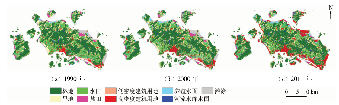
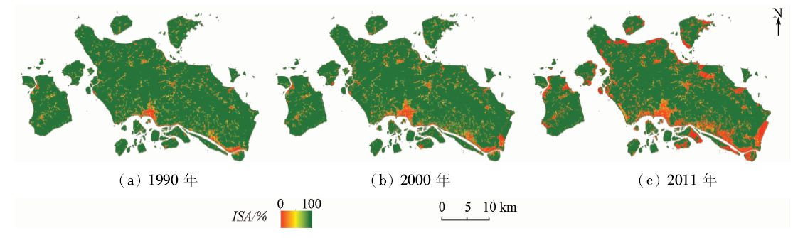
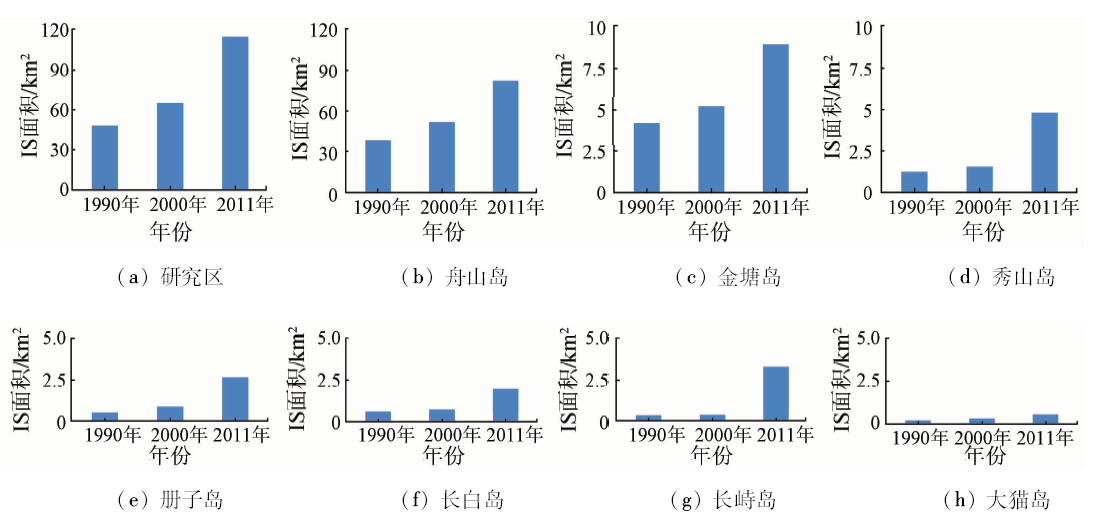
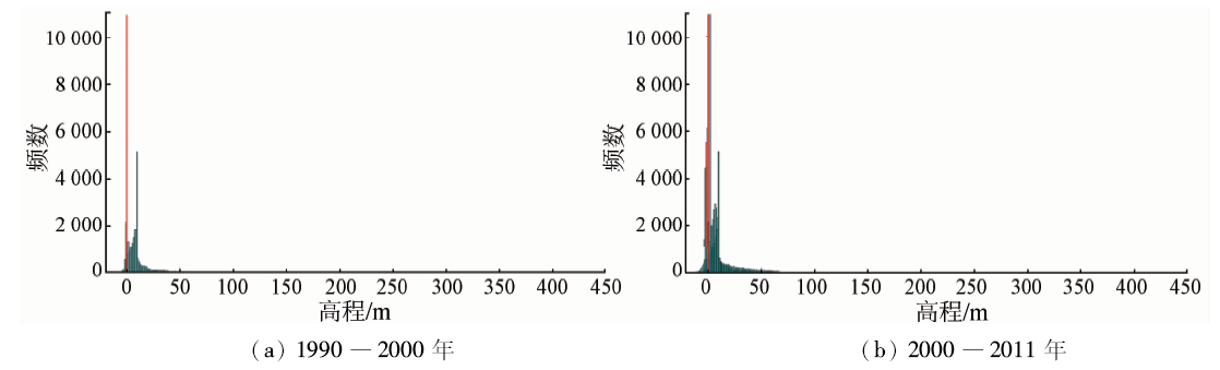
不透水面(impervious surfaces,IS)扩张加剧了海岛城市的淡水资源污染,是人类活动影响海岛生态系统脆弱性的重要因素之一。为分析舟山群岛IS动态变化,以覆盖舟山本岛及其附近岛屿同一季节的3期Landsat TM/ETM+遥感影像为主要数据源,通过监督分类获取研究区土地利用数据集,对非IS区域进行掩模运算; 利用城市建成区IS与植被覆盖度呈负相关的关系,提取1990年、2000年及2011年的IS变化信息。结果表明,在过去20 a中研究区IS面积呈快速增加趋势,由1990年的47.96 km 2(占研究区总面积的6.28%)增至2011年的114.40 km 2(占比16.27%),新增IS主要分布在舟山本岛老城区周边及附近岛屿沿岸地带,且逐渐向沿岸低高程区域扩张。地形、政策、功能定位及交通状况等因素抑或是舟山群岛IS时空格局变化的主要驱动力。
The expansion of impervious surfaces(IS)exacerbates the pollution of water resources in the island city, which is one of the important human factors affecting the vulnerability of island ecosystem. Landsat images acquired in three days of the same season were applied to monitor the dynamics of IS in Zhoushan Islands during 1990―2011. Firstly, the non-IS region was masked by the land use data set of the study area by supervised classification. Then, the complement of vegetation coverage was used to extract IS in 1990, 2000 and 2011. The results show that the IS expansions have occurred continuously over the past 20 years. The IS area in Zhoushan Islands increased from 47.96 km 2 (accounting for 6.28% of the total study area) in 1990 to 114.40 km 2 in 2011 (16.27%), and the increased IS were mostly located around the old city of Zhoushan Islands and along the periphery of surrounding islands. It is observed that the height of new IS was gradually changing to greater depth with time. The analysis indicates that the topography and the policy as well as the functions and transportation convenience are the dominant factors controlling the spatial patterns of IS and its expansions in Zhoushan Islands.
Weng Q H . Remote sensing of impervious surfaces in the urban areas:Requirements,methods,and trends[J]. Remote Sensing of Environment, 2012,117:34-49.
doi: 10.1016/j.rse.2011.02.030
Liu Z H, Wang Y L, Peng J . Remote sensing of impervious surface and its applications:A review[J]. Progress in Geography, 2010,29(9):1143-1152.
[3]
Chen J Y, Pan D L, Mao Z H , et al.Land-cover reconstruction and change analysis using multi-source remotely sensed imageries in Zhoushan Islands since 1970[J]. Journal of Coastal Research, 2014,30(2):272-282.
doi: 10.2112/JCOASTRES-D-13-00027.1
[4]
Carlson T N, Arthur S T . The impact of land use-land cover changes due to urbanization on surface microclimate and hydrology:A satellite perspective[J]. Global and Planetary Change, 2000,25(1/2):49-65.
doi: 10.1016/S0921-8181(00)00021-7
[5]
Xian G, Crane M . Assessments of urban growth in the Tampa Bay watershed using remote sensing data[J]. Remote Sensing of Environment, 2005,97(2):203-215.
doi: 10.1016/j.rse.2005.04.017
[6]
Powell R L, Roberts D A, Dennison P E , et al. Sub-pixel mapping of urban land cover using multiple endmember spectral mixture analysis:Manaus,Brazil[J]. Remote Sensing of Environment, 2007,106(2):253-267.
doi: 10.1016/j.rse.2006.09.005
Xu H Q .Urban expansion process in the center of the Fuzhou Basin,Southeast China in 1976―2006[J]. Scientia Geographica Sinica, 2011,31(3):351-357.
[8]
Zhang L, Weng Q H.Annual dynamics of impervious surface in the Pearl River Delta,China,from 1988 to 2013,using time series Landsat imagery[J]. ISPRS Journal of Photogrammetry and Remote Sensing, 2016,113:86-96.
doi: 10.1016/j.isprsjprs.2016.01.003
[9]
Im J, Lu Z Y, Rhee J , et al. Impervious surface quantification using a synjournal of artificial immune networks and decision/regression trees from multi-sensor data[J]. Remote Sensing of Environment, 2012,117:102-113.
doi: 10.1016/j.rse.2011.06.024
[10]
Zhao T, Wang J F . Use of Iidar-derived NDTI and intensity for rule-based object-oriented extraction of building footprints[J]. International Journal of Remote Sensing, 2014,35(2):578-597.
doi: 10.1080/01431161.2013.871394
[11]
Yan W Y, Shaker A, El-Ashmawy N . Urban land cover classification using airborne LiDAR data:A review[J]. Remote Sensing of Environment, 2015,158:295-310.
doi: 10.1016/j.rse.2014.11.001
Li D R, Luo H, Shao Z F . Review of impervious surface mapping using remote sensing technology and its application[J]. Geomatics and Information Science of Wuhan University, 2016,41(5):569-577.
[13]
Lu D S, Li G Y, Kuang W H , et al. Methods to extract impervious surface areas from satellite images[J]. International Journal of Digital Earth, 2014,7(2):93-112.
doi: 10.1080/17538947.2013.866173
Huang J B . Research on Typical Questions of China Islands,Sand Banks and Coral Reefs Remote Sensing Monitoring Application[D]. Qingdao:Ocean University of China, 2006.
[15]
Zhao B, Kreuter U, Li B , et al. An ecosystem service value assessment of land-use change on Chongming Island,China[J]. Land Use Policy, 2004,21(2):139-148.
doi: 10.1016/j.landusepol.2003.10.003
[16]
Quan B, Chen J F, Qiu H L , et al. Spatial-temporal pattern and driving forces of land use changes in Xiamen[J]. Pedosphere, 2006,16(4):477-488.
doi: 10.1016/S1002-0160(06)60078-7
[17]
Zhang X P, Pan D L, Chen J Y , et al. Using long time series of Landsat data to monitor impervious surface dynamics:A case study in the Zhoushan Islands[J]. Journal of Applied Remote Sensing, 2013,7(1):073515.
doi: 10.1117/1.JRS.7.073515
[18]
Gillies R R, Box J B, Symanzik J , et al. Effects of urbanization on the aquatic fauna of the Line Creek watershed, Atlanta-a satellite perspective[J]. Remote Sensing of Environment, 2003,86(3):411-422.
doi: 10.1016/S0034-4257(03)00082-8
[19]
Carlson T N, Ripley D A . On the relation between NDVI,fractional vegetation cover,and leaf area index[J]. Remote Sensing of Environment, 1997,62(3):241-252.
doi: 10.1016/S0034-4257(97)00104-1
 2018, Vol. 30
  ), 吕颖1, 张华国2, 李朝奎3