Reconstructing missing data in soil moisture content derived from remote sensing based on optimum interpolation
Jun LI1(), Heng DONG2(), Xiang WANG1, Lin YOU1
1.College of Geoscience and Surveying Engineering, China University of Mining and Technology(Beijing), Beijing 100083,China 2.School of Resources and Environmental Engineering, Wuhan University of Technology, Wuhan 430070,China
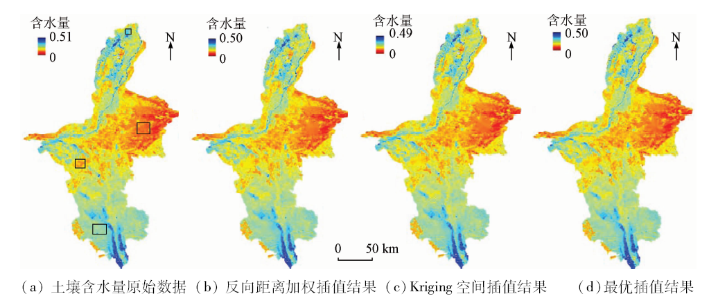
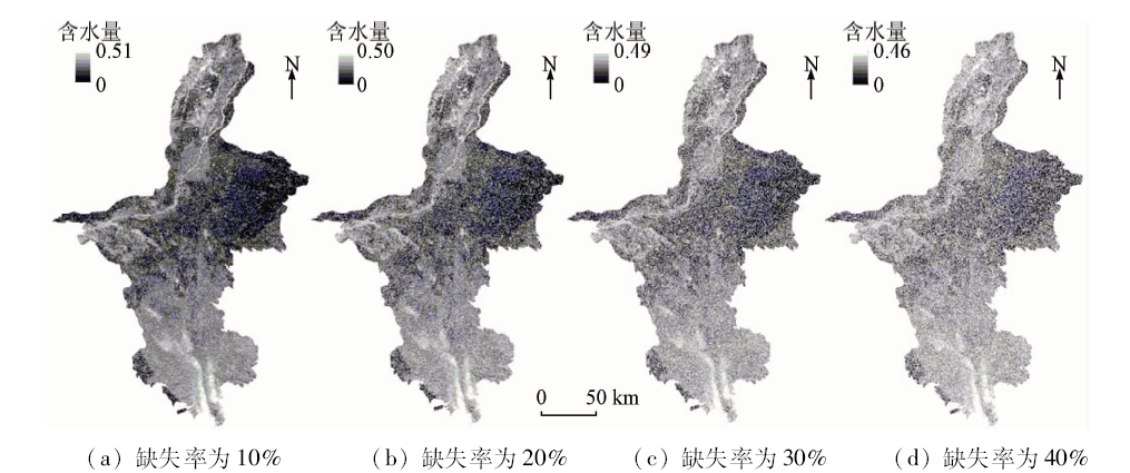
Remote sensing-based soil moisture content inversion is an indispensable procedure in drought monitoring; however, the image acquisition process is often influenced by bad weather such as cloud cover and snowfall, or sensor performance defects, which causes missing data. The existing filtering interpolation methods based on time series images have a high requirement on input data and thus are difficult to be widely applied, while the spatial interpolation methods do not work well for the images with missing blocks. In view of the above problems, this paper proposes a missing data filling method based on optimum interpolation, which predicts and fills missing data with the ground observation data as a reference. The authors selected Ningxia as the study area and obtained the soil moisture content in multiple periods using the VCADI index, and conducted missing pixel interpolation using the proposed method with the ground observation data of 16 national meterological stations. Experimental results show that the proposed method performs well in all regions with different levels of missing data. The authors simulated the images with missing blocks and different levels of missing data, and compared the performances between the inverse distance weighted interpolation method, the Kriging interpolation method and the optimum interpolation method. Experimental results show that the method proposed by the authors can obtain more accurate interpolation results.
李军, 董恒, 王祥, 游林. 基于最优插值的土壤含水量遥感反演缺失数据插补[J]. 国土资源遥感, 2018, 30(2): 45-52.
Jun LI, Heng DONG, Xiang WANG, Lin YOU. Reconstructing missing data in soil moisture content derived from remote sensing based on optimum interpolation. Remote Sensing for Land & Resources, 2018, 30(2): 45-52.
Wilhite D A, Buchanan-Smith M . Drought as Hazard:Understanding the Natural and Social Context[M] //Wilhite D A.Drought and Water Crises Science,Technology,and Management Issues.Boca Raton:Taylor and Francis Group, 2005.
Wu D H, Fan W J, Cui Y K , et al. Review of monitoring soil water content using hyperspectral remote sensing[J]. Spectroscopy and Spectral Analysis, 2010,30(11):3067-3071.
Yao Y J, Qin Q M, Zhao S H , et al. New index for soil moisture monitoring based on ΔTs-Albedo spectral information[J]. Spectroscopy and Spectral Analysis, 2011,31(6):1557-1561.
Sun H, Chen Y H, Sun H Q . Comparisons and classification system of typical remote sensing indexes for agricultural drought[J]. Transactions of the Chinese Society of Agricultural Engineering, 2012,28(14):147-154.
Zhao J, Zhang Y H, Huang W J , et al. Inversion of LAI by considering the hotspot effect for different geometrical wheat[J]. Spectroscopy and Spectral Analysis, 2014,34(1):207-211.
Wang P X, Wu G F, Bai X J , et al. Up-scaling transformation methods for vegetation temperature condition index retrieved from Landsat data[J]. Transactions of the Chinese Society for Agricultural Machinery, 2015,46(7):264-271.
[10]
Bradley B A, Jacob R W, Hermance J F , et al. A curve fitting procedure to derive inter-annual phenologies from time series of noisy satellite NDVI data[J]. Remote Sensing of Environment, 2007,106(2):137-145.
doi: 10.1016/j.rse.2006.08.002
[11]
Cihlar J, Ly H, Li Z Q , et al. Multitemporal,multichannel AVHRR data sets for land biosphere studies-Artifacts and corrections[J]. Remote Sensing of Environment, 1997,60(1):35-57.
doi: 10.1016/S0034-4257(96)00137-X
Li R, Zhang X, Liu B , et al. Review on methods of remote sensing time-series data reconstruction[J]. Journal of Remote Sensing, 2009,13(2):335-341.
[13]
Holben B N . Characteristics of maximum-value composite images from temporal AVHRR data[J]. International Journal of Remote Sensing, 1986,7(11):1417-1434.
doi: 10.1080/01431168608948945
[14]
Viovy N, Arino O, Belward A S . The best index slope extraction (BISE):A method for reducing noise in NDVI time-series[J]. International Journal of Remote Sensing, 1992,13(8):1585-1590.
doi: 10.1080/01431169208904212
[15]
Lovell J L, Graetz R D . Filtering pathfinder AVHRR land NDVI data for Australia[J]. International Journal of Remote Sensing, 2001,22(13):2649-2654.
doi: 10.1080/01431160116874
[16]
Ganzedo U, Alvera-Azcárate A, Esnaola G , et al. Reconstruction of sea surface temperature by means of DINEOF:A case study during the fishing season in the Bay of Biscay[J]. International Journal of Remote Sensing, 2011,32(4):933-950.
doi: 10.1080/01431160903491420
[17]
Park J, Tateishi R.Correction of time series NDVI by the method of temporal window operation[C]//Proceedings of 1998 Asian Conference on Remote Sensing, 1998.
[18]
Jonsson P, Eklundh L . Seasonality extraction by function fitting to time-series of satellite sensor data[J]. IEEE Transactions on Geoscience and Remote Sensing, 2002,40(8):1824-1832.
doi: 10.1109/TGRS.2002.802519
[19]
Savitzky A, Golay M J E.Smoothing and differentiation of data by simplified least squares procedures[J]. Analytical Chemistry, 1964,36(8):1627-1639.
doi: 10.1021/ac60214a047
[20]
Akhter S, Sarkar I, Rabbany K G , et al. Adapting the LMF temporal splining procedure from serial to MPI/Linux clusters[J]. Journal of Computer Science, 2007,3(3):130-133.
doi: 10.3844/jcssp.2007.130.133
Feng Y M, Lei X D, Lu Y C . Interpretation of pixel-missing patch of remote sensing image with Kriging interpolation of spatial statistics[J]. Journal of Remote Sensing, 2004,8(4):317-322.
Yu X Q, Ma A H . The spatial interpolation of missing remote sensing data in sea surface chlorophyll-a using Kriging[J].Bulletin of Surveying and Mapping, 2013(12):47-50.
Xiong X C, Yang C P, Ao M W , et al. A research on judging and removing stripe noises of MODIS image[J]. Remote Sensing Technology and Application, 2015,30(3):540-546.
Chen R X, Li X H . Restoring lost information on remote sensing images based on accessorial GIS data[J]. Geomatics and Information Science of Wuhan University, 2008,33(5):461-464.
Chen R X, Li X H, Li S Y . Texture synjournal and it’s application in restoring missing information on remote sensing images[J].Remote Sensing Information, 2009(5):15-18,86.
Zhu X X, Fan T X, Huang Q . Method to destripe imaging spectroradiometer data of SZ-3[J]. Journal of Infrared and Millimeter Waves, 2004,23(6):451-454.
[28]
Gandin L S . Objective Analysis of Meteorological Fields[M]. Gidromet:Almaty,Kazakhstan, 1963.
Li J T, Zhang P C . Optimum interpolation method used for measuring regional precipition with weather Radar[J]. Journal of Oceanography in Taiwan Strait, 1996,15(3):255-259.
Shen G R, Tian G L . Remote sensing monitoring of drought in Huanghe,Huaihe and Haihe Plain based on GIS-the calculation of crop water stress index model[J]. Acta Ecologica Sinica, 2000,20(2):224-228.
Zhu J, Xu Q C, Wang C Z , et al. Assimilation experiment of prediction data of sea surface temperature I:Objective analysis of optimum interpolation[J]. Acta Oceanologica Sinica, 1995,17(6):9-20.
Ma Z P, Jing A Q . Dynamic interpolation and its application in data assimilation[J]. Journal of Hebei University(Natural Science Edition), 2004,24(6):574-580.
[33]
Ghulam A, Li Z L, Qin Q M , et al. Exploration of the spectral space based on vegetation index and albedo for surface drought estimation[J]. Journal of Applied Remote Sensing, 2007,1(1):013529.
doi: 10.1117/1.2784792
Zhang X Z, Liu B R, Zhan S R . Distribution area and profile features of twelve soil types in Ningxia[J]. Ningxia Journal of Agriculture and Forestry Science and Technology, 2011,52(9):48-50,63.
 2018, Vol. 30
  ), 董恒2(