1. China Aero Geophysical Survey and Remote Sensing Center for Natural Resources, Beijing 100083,China 2. AeroImgInfo Technology Co., Ltd., Beijing 100195, China
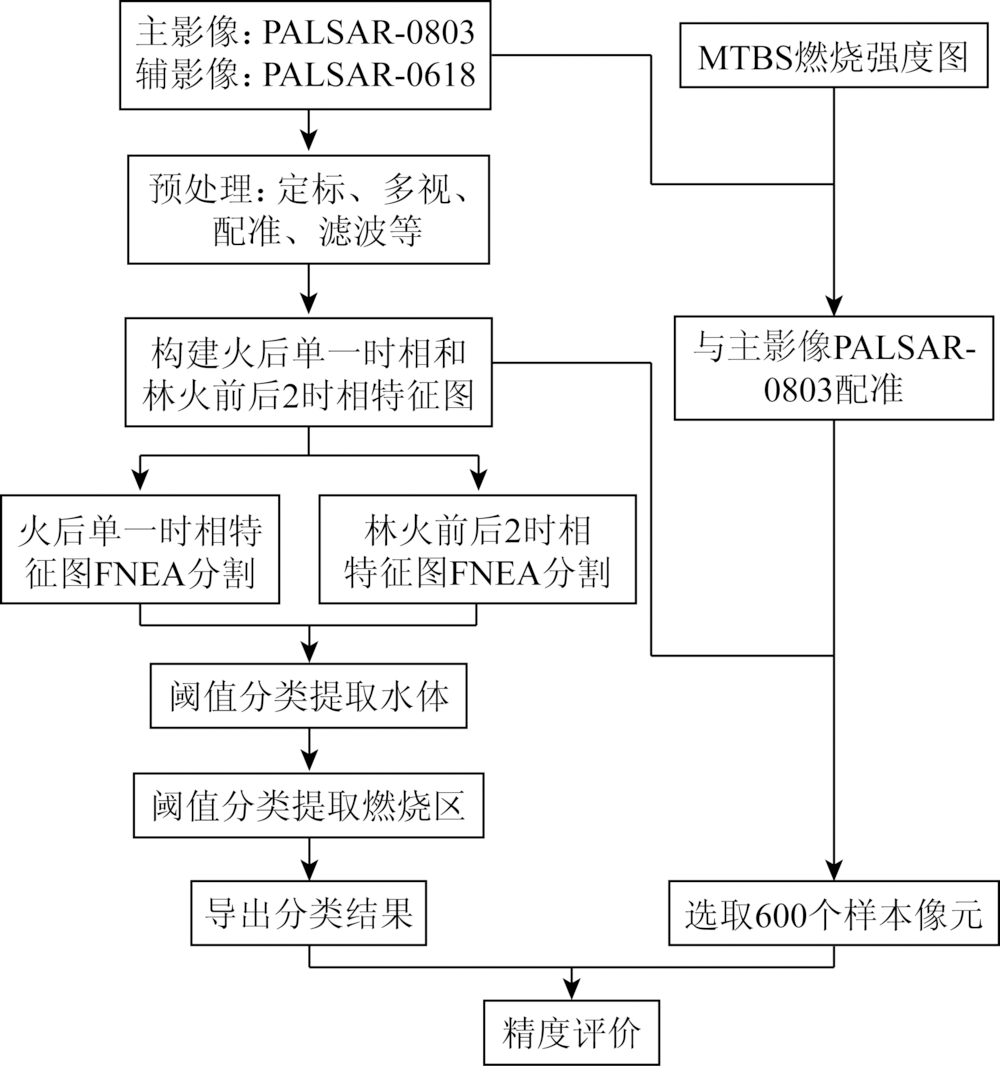
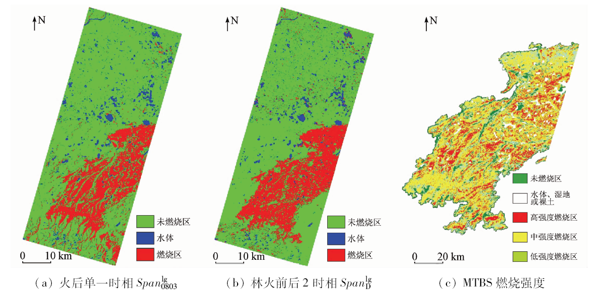
At present, the extraction accuracy of the forest fire area by synthetic aperture Radar (SAR) is mainly limited to the analysis of single pixel. However, the application study of object-oriented technology based on pixel sets as the analysis unit is less in dealing with SAR images. In this paper, a multi-scale segmentation algorithm based on fractal net evolution approach (FNEA) was applied to the span of ALOS PALSAR images. Through the application research, the forest fire region, which happened in 2009 and was located in the Middle East of Alaska, USA, was extracted. The application validation of the algorithm was verified by comparing the experiment results with the auxiliary data of monitoring trends in burn severity (MTBS) data. The experiment results show that the classification accuracies of one-static span and two-static spans based on object-oriented analysis are improved by 12.7% and 15.8% respectively, compared with precious research. The researches show that object-oriented technology can be effectively applied to the information extraction form SAR image, and SAR technology has potential application in forest fire monitoring.
姜德才, 李文吉, 李敬敏, 白罩峰. ALOS PALSAR散射总功率的面向对象林火区提取[J]. 国土资源遥感, 2019, 31(4): 47-52.
Decai JIANG, Wenji LI, Jingmin LI, Zhaofeng BAI. Extraction of the forest fire region based on the span of ALOS PALSAR by object-oriented analysis. Remote Sensing for Land & Resources, 2019, 31(4): 47-52.
Li M Z, Kang X R, Fan W Y . Burned area extraction in Huzhong forests based on remote sensing and the spatial analysis of the burned severity[J]. Scientia Silvae Sinicae, 2017,53(3):163-174.
[2]
Tanase M, Santoro M, Juan D L R,et al.L-band SAR backscatter prospects for burn severity estimation in Boreal Forests [C]//ESA Living Planet Symposium, 2010.
[3]
Tanase M A, Santoro M, Aponte C , et al. Polarimetric properties of burned forest areas at C- and L-band[J]. IEEE Journal of Selected Topics in Applied Earth Observations and Remote Sensing, 2013,7(1):267-276.
Tan L X, Zeng Y N, Zheng Z . An adaptability analysis of remote sensing indices in evaluating fire severity[J]. Remote Sensing for Land and Resources, 2016,28(2):84-90.doi: 10.6046/gtzyyg.2016.02.14.
Sun G F, Qin X L, Liu S C , et al. Potential analysis of typical vegetation index for identifying burned area[J]. Remote Sensing for Land and Resources, 2019,31(1):204-211.doi: 10.6046/gtzyyg.2019.01.27.
[6]
祁帅 . 极化SAR林火燃烧面积提取与燃烧强度估计[D]. 兰州:兰州交通大学, 2015.
Qi S . Polarimetric SAR Forest Fire Scars Extraction and Burn Severity Estimation[D]. Lanzhou:Lanzhou Jiaotong University, 2015.
Jiang D C . Repeat-Pass Spaceborne SAR Interferometry for DEM Generation in Cloudy-Rainy Mountianous Area[D]. Beijing:Chinese Academy of Surveying and Mapping, 2017.
Qi S, Zhang Y H, Wang H Q . Analysis of fire disturbed forests scattering characteristics using polarimetric SAR image[J]. Remote Sensing for Land and Resources, 2016,28(2):48-53.doi: 10.6046/gtzyyg.2016.02.08.
Tang L Y, Liu W, Yang D , et al. Flooding monitoring application based on the object-oriented method and Sentinel-1A SAR data[J]. Journal of Geo-Information Science, 2018,20(3):377-384.
Zhang H, Ye X, Wang C , et al. The processing and application of high resolution SAR images with object-based image analysis[J]. Journal of Image and Graphics, 2018,19(3):344-357.
Wang M, Wan Q M, Zhang D Q , et al. Multi-resolution remotely sensed image segmentation in combination with spectral and shape features[J]. Journal of Geo-Information Science, 2010,12(2):261-268.
[12]
Baatz M, Schäpe A. Object-oriented and multi-scale image analysis in semantic networks [C]//Proceedings of the 2nd International Symposium on Operationalization of Remote Sensing, 1999.
[13]
Baatz M, Schäpe A . Multiresolution segmentation:An optimization approach for high quality multiscale image segmentation[J]. Journal of Photogrammetry and Remote Sensing, 2007,58:3-4.
Zhang L X, Ruan R Z, Xia S . Parameter analysis of image texture of wetland in the Hongze Lake[J]. Remote Sensing for Land and Resources, 2015,27(1):75-80.doi: 10.6046/gtzyyg.2015.01.12.
[16]
Comber A, Fisher P, Brunsdon C , et al. Spatial analysis of remote sensing image classification accuracy[J]. Remote Sensing of Environment, 2012,127(140):237-246.
[17]
Tortora R D . A note on sample size estimation for multinomial populations[J]. The American Statistician, 1978,32(3):100-102.
[18]
Zeng M H, Zhong M, Hunt J D . Analysis of the impact of sample size,attribute variance and within-sample choicedistribution on the estimation accuracy of multinomial logit models using simulated data[J]. Journal of Systems Science and Systems Engineering, 2018,27(6):771-789.
 2019, Vol. 31