1. Key Lab of 3D Information Acquisition and Application, Ministry of Education, Beijing 100048, China 2. The State Key Laboratory Breeding Base of Process of Urban Environment and Digital Simulation, Beijing 100048, China 3. School of Resources Environment and Tourism, Capital Normal University, Beijing 100048, China 4. Beijing Advanced Innovation Center for Imaging Technology, Capital Normal University, Beijing 100048, China 5. Qinghai-Tibet Plateau Research Institute, Chinese Academy of Sciences, Beijing 100101, China
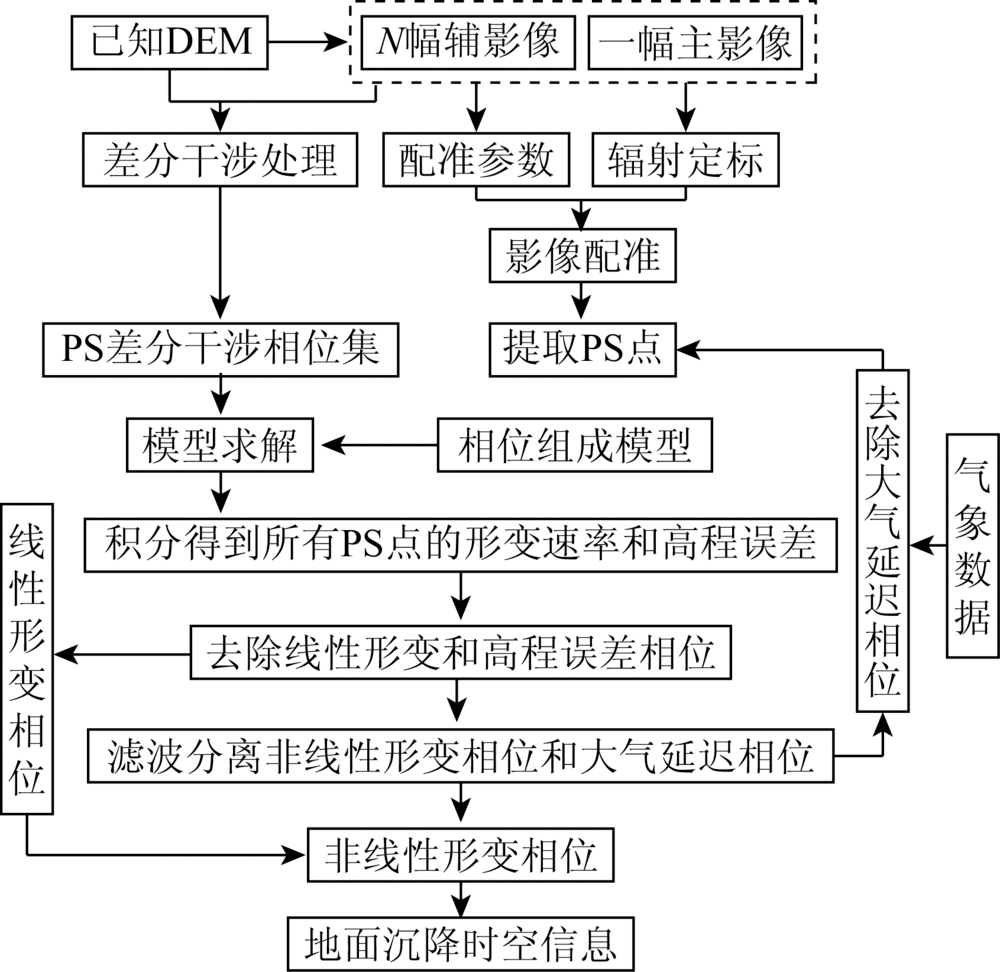
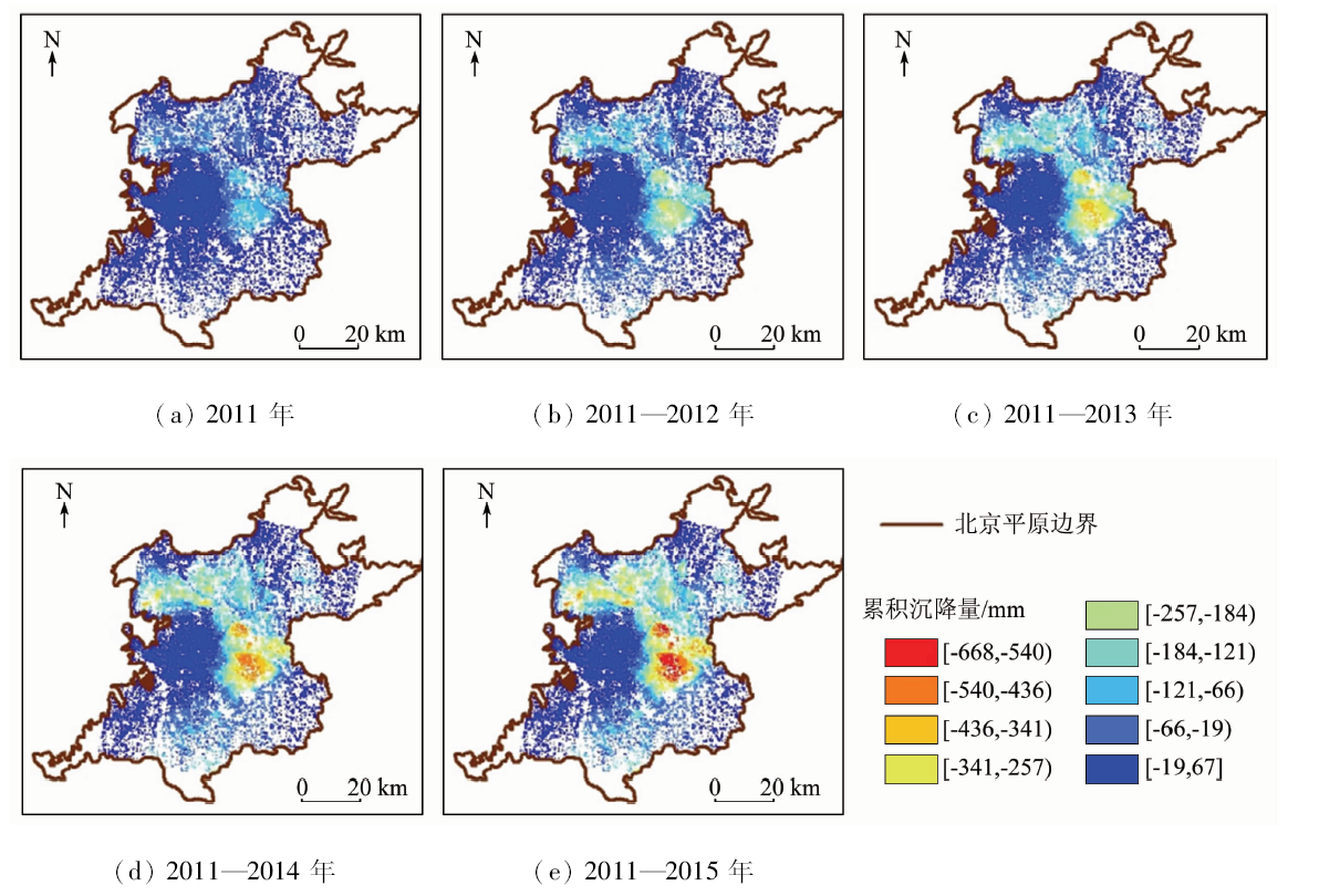
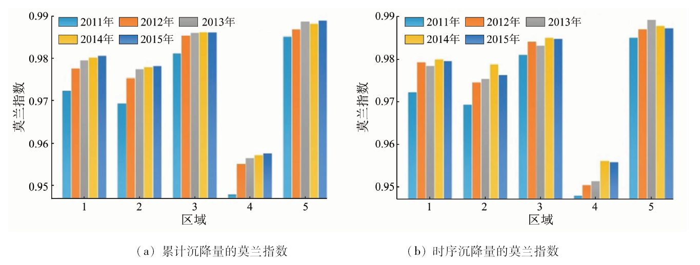
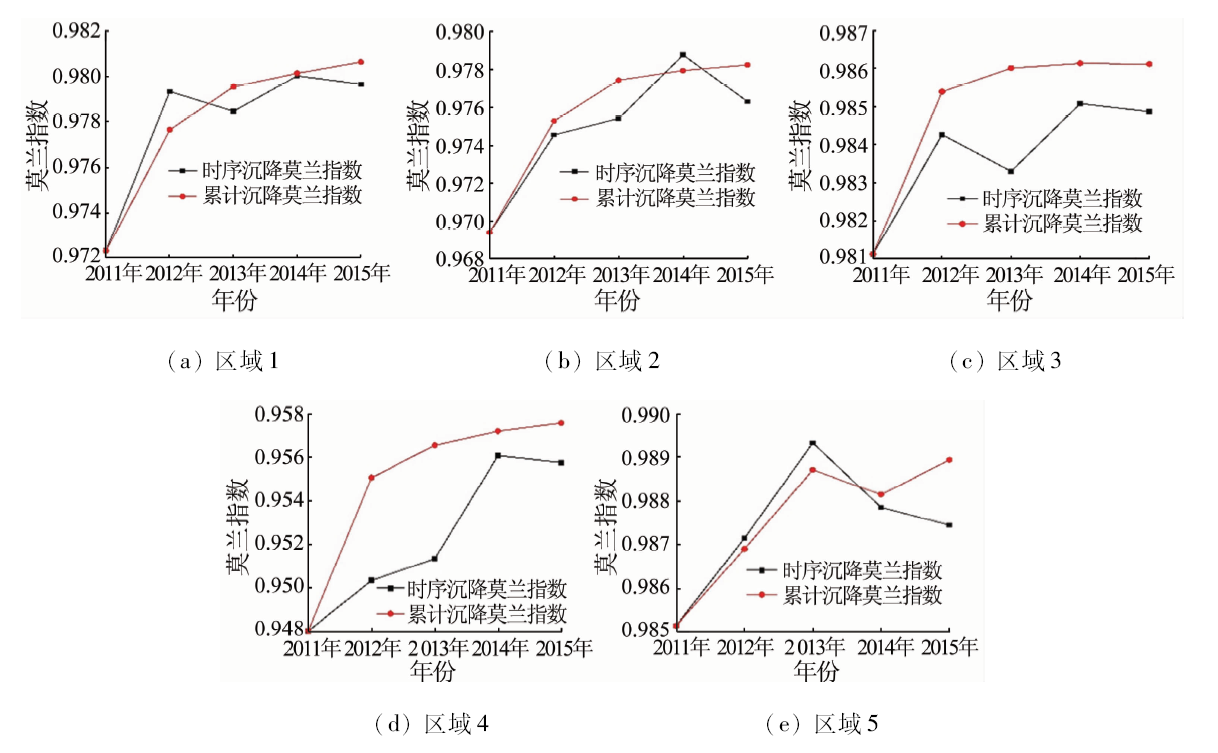
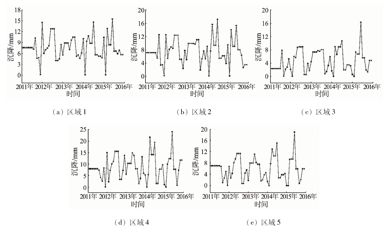
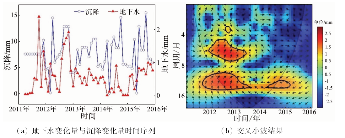
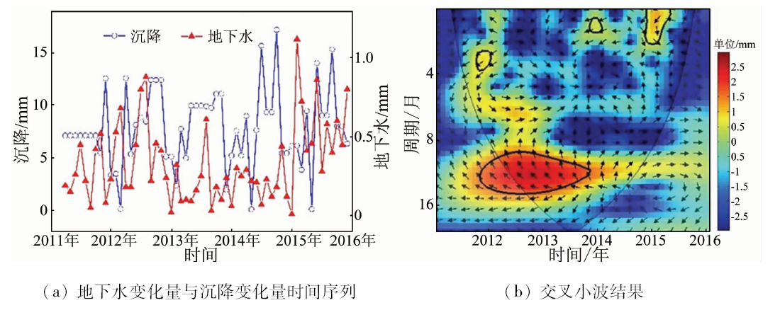
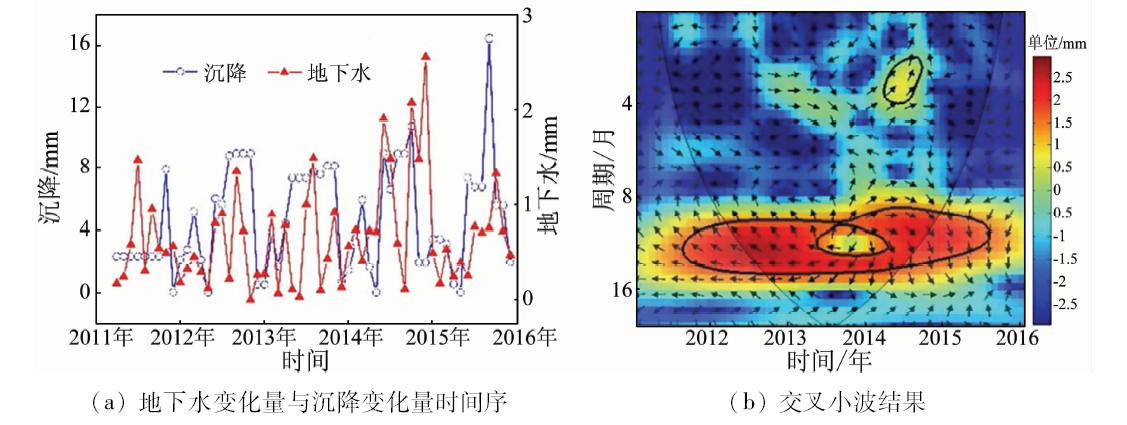
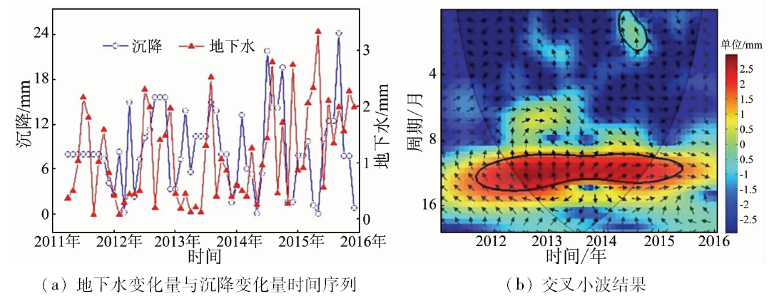
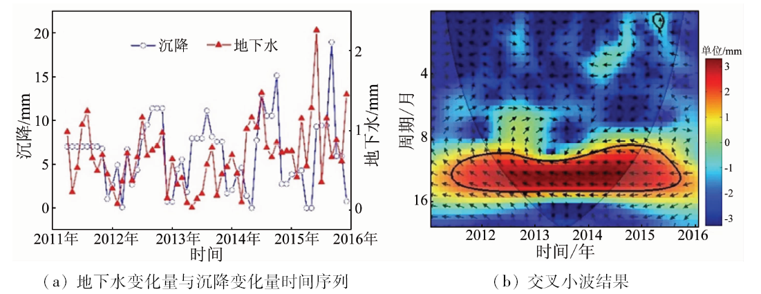
To address the problem that quantitative analysis of uneven subsidence is rare, the authors used the Permanent Scatterer Interferometry (PSI) to monitor land subsidence in the Beijing plain. According to the different shallow surface spatial utilizations, the authors selected 5 typical areas in the subsidence funnel region. Based on spatial autocorrelation analysis and wavelet analysis, the authors quantified the degree of spatial and annual time series uneven subsidence in each area, and studied the influence of different shallow surface spatial utilization and groundwater level variation on spatial and annual time series uneven subsidence. The results are as follows: ①Annual time series subsidence’s Moran index degrees of 5 areas are the same as those of the accumulated subsidence: I5>I3>I1>I2>I4. According to the utilization of shallow surface space, the degree of uneven subsidence of 1, 2, 5 areas are positively correlated with the complexity of space utilization, and the factors affecting the uneven subsidence degree of area 3, 4 are complicated. ②It is found that the variation and duration of groundwater level fluctuation are the main factors affecting the uneven degree of time series subsidence.
Gong H L, Zhang Y Q, Li X J, et al. Land subsidence research in Beijing based on permanent scatterer radar interferometry[J]. Progress in natural science, 2009,19(11):1261-1266.
doi: 10.1016/j.pnsc.2009.02.005
Yang Y, Jia S M, Wang H G. Analysis of land subsidence status and development trend in Beijing plain area[J]. Land and Resources of Shanghai, 2010,31(4):23-28.
[3]
Li Y S, Jingfa Z, Zhang J, et al. Land subsidence in Beijing City from InSAR time series analysis with small baseline subset[J]. Geomatics & Information Science of Wuhan University, 2013,38(11):1374-1377.
Lei K C, Chen B B, Jia S M, et al. Preliminary study on characteristics and causes of land subsidence in Beijing based on PS-InSAR technology[J]. Spectroscopy and spectral analysis, 2014,34(8):2185-2189.
Zhou C F. Study on uneven land subsidence in typical areas of Beijing based on PS-InSAR technology and information entropy[D]. Beijing:Capital Normal University, 2014.
[6]
杜钊锋. 北京典型区域不均匀地面沉降成因机制分析[D]. 北京:首都师范大学, 2013.
Du Z F. Cause analysis of uneven land subsidence in typical areas of Beijing[D]. Beijing:Capital Normal University, 2013.
Chen B B, Gong H L, Li X J, et al. Study on temporal evolution of land subsidence by integrated time series InSAR and GIS technology[J]. Spectroscopy and spectral analysis, 2014,34(4):1017-1025.
[8]
Hu B, Wang H S, Sun Y L, et al. Long-term land subsidence monitoring of Beijing(China) using the small baseline subset(SBAS) technique[J]. Remote Sensing, 2014,6(5):3648-3661.
Zhou B F, Li X J, Li Y P. Progress and reflection on land subsidence characteristics and research approaches in Beijing Plain[J].China Mining Industry, 2014(12):51-56.
[10]
Chen B, Gong H, Li X, et al. Spatial-temporal evolution patterns of land subsidence with different situation of space utilization[J]. Natural Hazards, 2015,77(3):1765-1783.
Zhou C F, Gong H L, Chen B B, et al. Spatial pattern analysis of land subsidence in typical areas of Beijing[J].Remote sensing information, 2017(4):24-29.
[12]
袁立明. 全球地面沉降扫描[J].地球, 2012(s1):156-159.
Yuan L M. Scanning of Global Land Subsidence[J].Earth, 2012(s1):156-159.
[13]
Ferretti A, Prati C, Rocca F. Nonlinear subsidence rate estimation using permanent scatterers in differential SAR interferometry[J]. IEEE Transactions on Geoscience & Remote Sensing, 2000,38(5):2202-2212.
[14]
Ferretti A, Colesanti C, Prati C, et al. Radar permanent scatterers identification in urban areas:Target characterization and sub-pixel analysis [C]//Remote Sensing and Data Fusion Over Urban Areas,Ieee/isprs Joint Workshop.Rome:IEEE, 2001: 52.
[15]
Hooper A, Zebker H, Segall P, et al. A new method for measuring deformation on volcanoes and other natural terrains using InSAR persistent scatterers[J]. Geophysical Research Letters, 2004,31(23):1-5.
[16]
Tobler W R. A Computer Movie Simulating Urban Growth in the Detroit Region[C]//International Geographical Union,Commission on Quantitative Methods.Economic Geography.America:Clark University, 1970(46):234-240.doi: 10.2307/143141
 2020, Vol. 32
  ), 陈蓓蓓1,2,3, 周超凡1,2,3,4, 陈文锋5, 张晓婧1,2,3