1. National-Local Joint Engineering Laboratory of Geo-spatial Information Technology, Hunan University of Science and Technology, Xiangtan 411201, China 2. School of Resource,Environment and Safety Engineering, Hunan University of Science and Technology, Xiangtan 411201, China
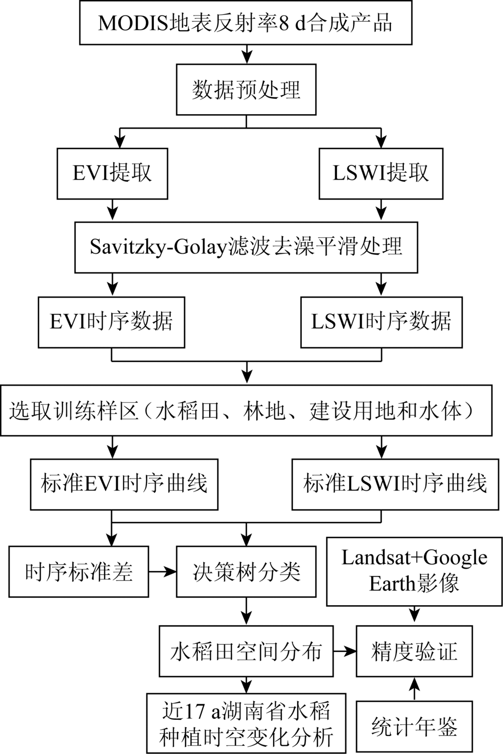
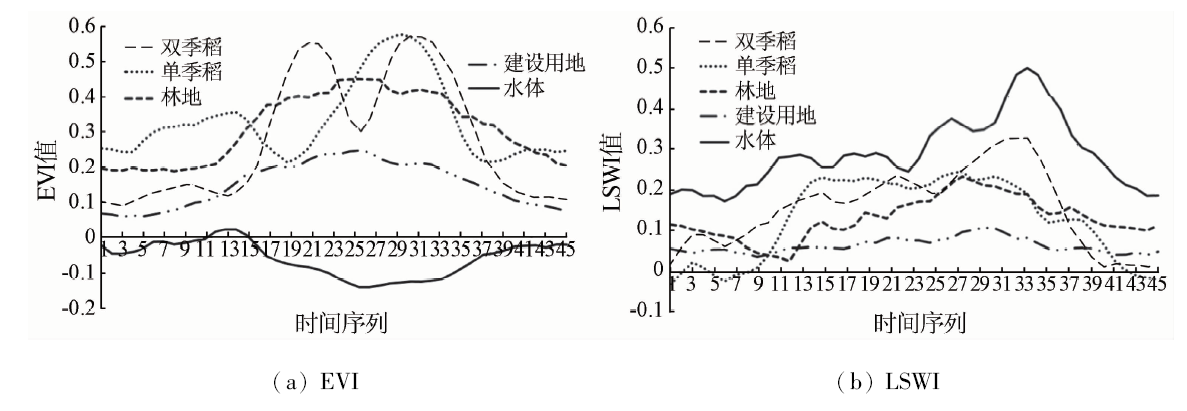
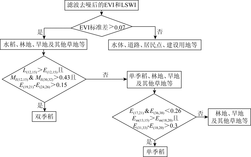
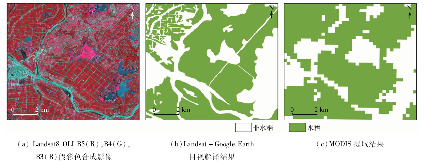
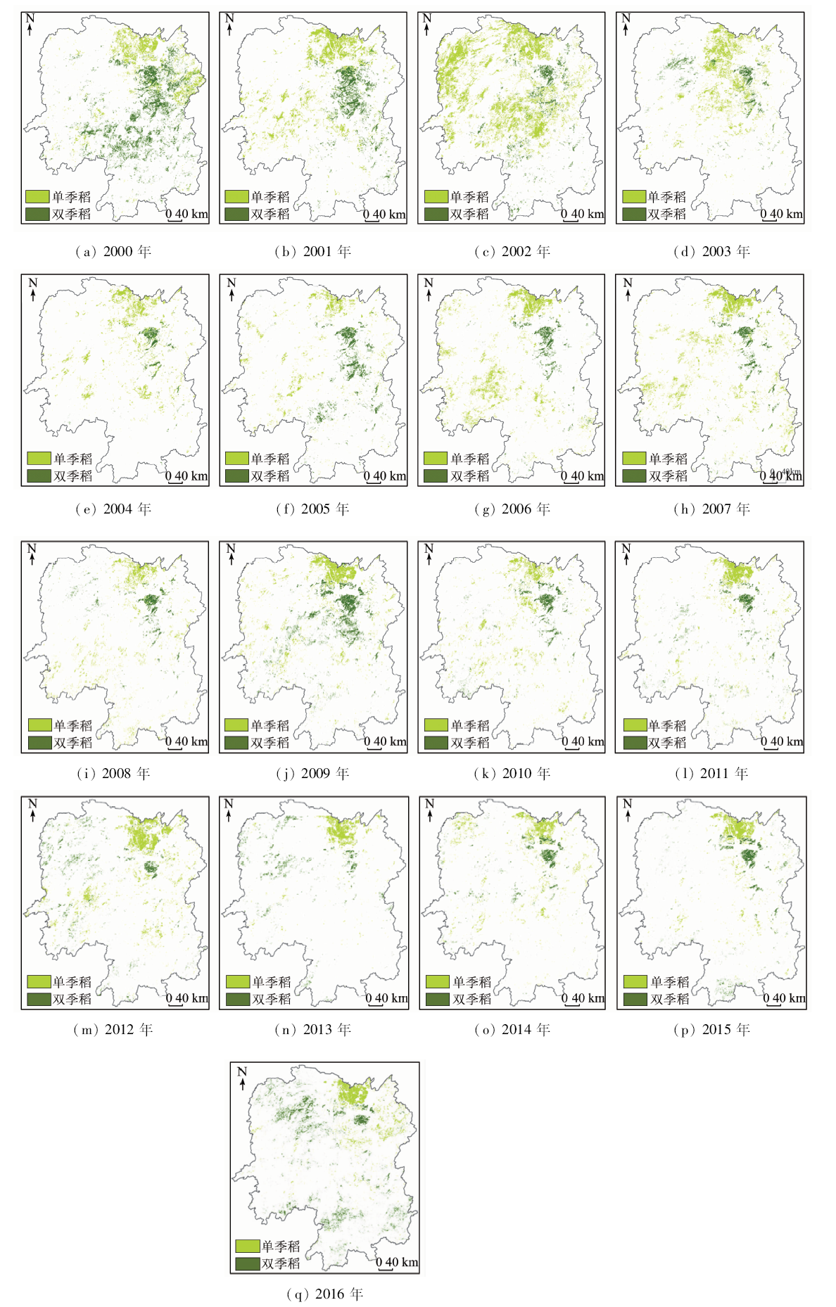
It is essential to obtain a wide range of spatial distribution and dynamic change information of paddy rice timely and accurately for scientific guidance of rice production, rational utilization of water resources, and monitoring of atmospheric environmental changes. In this study, the decision tree extraction model of rice planting area in Hunan Province was constructed on the basis of time series variation characteristics of MODIS-derived LSWI and EVI in rice planting area, and the accuracy of the model was evaluated. In addition, the spatiotemporal variation characteristics of the rice planting areas in Hunan Province from 2000 to 2016 were investigated. The results are as follows: the total classification accuracy of rice planting area extraction model in the research area is 90.2%, the Kappa coefficient is 0.74 and; in comparison with agriculture statistics, the mean relative error is 13.6%. The proposed extraction model can be applied to the efficient extraction of rice planting area on a wide range and long time series basis. The average annual rice planting area in Hunan Province is 3 441.2 thousand hectares, of which 1 024.1 thousand hectares are single-cropping rice, mainly distributed in the Dongting Lake plain, and 2 417.1 thousand hectares are double-cropping rice, mainly distributed in the north-central part of Hunan Province such as Yueyang, Yiyang, Changde, Changsha, Zhuzhou, Xiangtan and Loudi City. the rice planting area in Hunan Province was reduced by 732 thousand hectares from 2000 to 2004, reached a relatively stable level in 2005—2010 and increased by 295.5 thousand hectares in 2011—2016. Overall, there existed a decreasing trend from 2000 to 2016, with the rice planting area reduced by 582.2 thousand hectares.
邓刚, 唐志光, 李朝奎, 陈浩, 彭焕华, 王晓茹. 基于MODIS时序数据的湖南省水稻种植面积提取及时空变化分析[J]. 国土资源遥感, 2020, 32(2): 177-185.
Gang DENG, Zhiguang TANG, Chaokui LI, Hao CHEN, Huanhua PENG, Xiaoru WANG. Extraction and analysis of spatiotemporal variation of rice planting area in Hunan Province based on MODIS time-series data. Remote Sensing for Land & Resources, 2020, 32(2): 177-185.
Chen X H. Agricultural statistics in China (2013)[M].China Agriculture Press, 2014.
[2]
Brenkert A L, Smith S J, Kim S H, et al. Model documentation for the MiniCAM[R].Pacific Northwest National Lab.(PNNL),Richland,WA(United States), 2003.
[3]
Masuoka P M, Claborn D M, Andre R G, et al. Use of IKONOS and Landsat for malaria control in the Republic of Korea[J]. Remote Sensing of Environment, 2003,88(1-2):187-194.
doi: 10.1016/j.rse.2003.04.009
Xu X G, Li Q Z, Zhou W C, et al. Classification application of QuickBird imagery to obtain crop planting area[J]. Remote Sensing Technology and Application, 2008,23(1):17-25.
[5]
Yoshikawa N, Shiozawa S. Estimating variable acreage of cultivated paddy fields from preceding precipitation in a tropical watershed utilizing Landsat TM/ETM[J]. Agricultural water management, 2006,85(3):296-304.
Huang Z G, Chen Z X, Liu F Q, et al. Mapping rice planting area using SPOT5 imagery:Taking Zhuzhou,Hunan as an example[J]. Journal of Hunan Agricultural University, 2013,39(2):137-140.
Zheng C C, Wang X Z, Huang J F. Decision tree algorithm of automatically extracting paddy rice information from SPOT-5 images based on characteristic bands[J]. Remote Sensing Technology and Application, 2008,23(3):294-299.
Zhong S Q, Mo J F, Chen Y L, et al. Study on rice identification technology using HJ-1B data[J]. Remote Sensing Technology and Applications, 2010,25(4):464-468.
[9]
Xiao X, Boles S, Frolking S, et al. Mapping paddy rice agriculture in South and Southeast Asia using multi-temporal MODIS images[J]. Remote Sensing of Environment, 2006,100(1):95-113.
[10]
Xiao X, Boles S, Frolking S, et al. Observation of flooding and rice transplanting of paddy rice fields at the site to landscape scales in China using Vegetation sensor data[J]. International Journal of Remote Sensing, 2002,23(15):3009-3022.
doi: 10.1080/01431160110107734
Li Y Z, Zeng Y. Study on methods of rice planting area estimation at regional scale using NOAA/AVHRR data[J]. Journal Of Remote Sensing, 1998,2(2):125-130.
[12]
Bouvet A, Toan T L. Use of ENVISAT/ASAR wide-swath data for timely rice fields mapping in the Mekong River Delta[J]. Remote Sensing of Environment, 2011,115(4):1090-1101.
[13]
Ribbes F, Toan T L. Mapping and monitoring rice crop with RADARSAT data [C]// IEEE International Geoscience & Remote Sensing Symposium, 1998.
[14]
Zhang Y, Wang C, Wu J, et al. Mapping paddy rice with multitemporal ALOS/PALSAR imagery in southeast China[J]. International Journal of Remote Sensing, 2009,30(23):6301-6315.
doi: 10.1080/01431160902842391
[15]
Gumma M K, Nelson A, Thenkabail P S, et al. Mapping rice areas of South Asia using MODIS multitemporal data[J]. Journal of applied remote sensing, 2011,5(1):053547.
[16]
Son N T, Chen C F, Chen C R, et al. A comparative analysis of multitemporal MODIS EVI and NDVI data for large-scale rice yield estimation[J]. Agricultural and forest meteorology, 2014,197(6):52-64.
[17]
Zhang G L, Xiao X M, Dong J W, et al. Mapping paddy rice planting areas through time series analysis of MODIS land surface temperature and vegetation index data[J]. ISPRS Journal of Photogrammetry and Remote Sensing, 2015,106:157-171.
Miao C C, Jiang N, Peng S K, et al. Extraction of paddy land area based on NDVI time-series data:Taking Jiangsu Province as an example[J]. Journal of Geo-Information Science, 2011,13(2):273-280.
Wu M Q, Wang C Y, Niu Z. Mapping paddy fields in large areas, based on time series multi-sensors data[J]. Transactions of the Chinese Society of Agricultural Engineering, 2010,26(7):240-244.
Yang S B, Jing Y S, Wang L, et al. Mapping rice paddy distribution in Henan Province based on multi-temporal MODIS imagery[J]. Transactions of Atmospheric Sciences, 2012,35(1):113-120.
Zhang L, Wu W B, Zuo L J. Extracting planting area of paddy rice in southern China by using EOS/MODIS data[J]. Journal of China Agricultural Resources and Regional Planning, 2011,32(4):39-44.
Zheng C C, Wang X Z, Huang J F. Mapping paddy rice planting area in Zhejiang Province using multi-temporal MODIS images[J]. Journal of Zhejiang University(Agriculture and Life Sciences), 2009,35(1):98-104.
Cao D, Bai L Y, Feng J Z, et al. Monitoring and analysis of temporal and spatial variation of rice planting area in northeastern China[J]. Jiangsu Agricultural Sciences, 2018,46(10):260-265,271.
Gu J, Li X, Huang C L. Research on the Reconstructing of Time-series NDVI Data[J]. Remote Sensing Technology and Application, 2006,21(4):391-395.
[25]
田波. 湖南水稻的比较优势与竞争力分析[J].新疆农垦经济, 2006(1):35-37.
Tian B. Analysis on the Comparative Advantage and Competition Dynamics of Rice in Hunan[J].Xinjiang State Farms Economy, 2006(1):35-37.
[26]
Huete A, Didan K, Miura T, et al. Overview of the radiometric and biophysical performance of the MODIS vegetation indices[J]. Remote Sensing of Environment, 2002,83(1-2):195-213.
doi: 10.1016/S0034-4257(02)00096-2
[27]
Sakamoto T, Yokozawa M, Toritani H, et al. A crop phenology detection method using time-series MODIS data[J]. Remote Sensing of Environment, 2005,96(3-4):366-374.
[28]
Xiao X, Boles S, Liu J, et al. Mapping paddy rice agriculture in southern China using multi-temporal MODIS images[J]. Remote Sensing of Environment, 2005,95(4):480-492.
doi: 10.1016/j.rse.2004.12.009
[29]
Jonsson P, Eklundh L. TIMESAT—a program for analyzing time-series of satellite sensor data[J]. Computers & Geosciences, 2004,30(8):833-845.
[30]
Jonsson P, Eklundh L. Seasonality extraction by function fitting to time-series of satellite sensor data[J]. IEEE Transactions on Geoscience and Remote Sensing, 2002,40(8):1824-1832.
Sun H S. Extracting Planting Area and Growth Information of Paddy Rice using Multi-temporal MODIS Data in China[D]. Hangzhou:Zhejiang University, 2009.
Wu W B, Yang P, Tang H J, et al. Comparison of two fitting methods of NDVI time series datasets[J]. Transactions of the Chinese Society of Agricultural Engineering, 2009,25(11):183-188.
 2020, Vol. 32
  ), 李朝奎1, 陈浩1, 彭焕华1, 王晓茹1,2