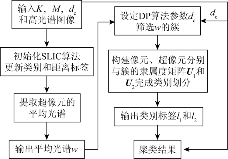
In order to give full play to the advantages of hyperspectral spatial information and peak density clustering algorithm in dividing remote sensing image features, this paper proposes a hyperspectral image classification method based on the combination of hyperpixel and peak density features. Superpixel segmentation technology makes full use of the spatial and spectral information of hyperspectral images, dividing hyperspectral images into hyperpixels, extracting the gray value of hyperpixels as an important feature of peak density classification, selecting the spectrum with the highest peak density as the spectral cluster of the whole image, using the visual and hyperpixels as the basic units of classification, and then obtaining the pixels and hyperpixels respectively. The membership relation is obtained by the difference between spectral clusters. Finally, the image classification is completed by combining the membership degree. Experiments show that the proposed algorithm takes less time than other methods under the condition of ensuring the highest classification accuracy, and meets the requirements of hyperspectral image information extraction and analysis.
孙珂. 融合超像元与峰值密度特征的遥感影像分类[J]. 国土资源遥感, 2020, 32(4): 41-45.
SUN Ke. Remote sensing image classification based on super pixel and peak density. Remote Sensing for Land & Resources, 2020, 32(4): 41-45.
Cui B G, Wu Y N, Zhong Y. Rolling guided recursive filtering and feature classification of hyperspectral images[J]. Journal of Remote Sensing, 2019,23(3):431-442.
Gong X, Wu L, Xie Z, et al. Classification method of high-resolution remote sensing scenes based on fusion of global and local deep features[J]. Acta Optica Sinica, 2019,39(3):19-29.
Gu Y, Xu Y, Guo B F. Hyperspectral image classification by combination of spatial-spectral features and ensemble extreme learning matchines[J]. Acta Geodaetica et Cartographica Sinica, 2018,47(9):1238-1249.
Chen Y, Fan R S, Xu Q H, et al. A high resolution image classification method considering spectral similarity and phase consistency[J]. Science of Surveying and Mapping, 2018,43(11):142-146.
[5]
Rodriguez A, Laio A. Clustering by fast search and find of density peaks[J]. Science, 2014,344(6191):1492-1496.
doi: 10.1126/science.1242072
pmid: 24970081
[6]
许毅平. 基于高光谱图像多特征分析的目标提取研究[D]. 武汉:华中科技大学, 2008.
Xu Y P. Study on object extraction based on multi-feature from hyperspectral image[D]. Wuhan:Huazhong University of Science and Technology, 2008.
Tang G H. Ranking-based-clustering and superpixel segmentation for hyperspectral remote imagery dimensionality reduction[D]. Shenzhen:Shenzhen University, 2016.
[8]
Sun X, Yang L, Gao L, et al. Hyperspectral image clustering method based on artificial bee colony algorithm and Markov random fields[J]. Journal of Applied Remote Sensing, 2015,9(1):095047.
[9]
Ren X, Malik J. Learning a classification model for segmentation[C]// Proceedings of Ninth IEEE International Conference on Computer Vision, 2003.
Fang X, Wang G H, Yang H C, et al. Remote sensing imageries change detection combined with mean-shift segmentation and cluster analysis[J]. Bulletin of Surveying and Mapping, 2017(12):68-71.
[11]
Achanta R, Shaji A, Smith K, et al. SLIC superpixels compared to state-of-the-art superpixel methods[J]. IEEE Transactions on Pattern Analysis and Machine Intelligence, 2012,34(11):2274-2282.
doi: 10.1109/TPAMI.2012.120
pmid: 22641706
[12]
Ren C Y, Reid I. gSLIC:A real-time implementation of SLIC superpixel segmentation[R]. Oxford:University of Oxford,Department of Engineering, 2011.
[13]
Kim K S, Zhang D, Kang M C, et al. Improved simple linear iterative clustering superpixels[C]// IEEE International Symposium on Consumer Electronics. IEEE, 2013.
[14]
Saranathan A M, Parente M. Uniformity-based superpixel segmentation of hyperspectral images[C]// IEEE Transactions on Geoscience and Remote Sensing. IEEE, 2016,54(3):1419-1430.
 2020, Vol. 32
  )
)