Spatiotemporal fusion of remote sensing images based on particle swarm optimization and pixel decomposition
ZHANG Hongli1(), LUO Weiran2(), LI Yan1,2
1. Zhengzhou Vocational College of Industrial Safety, Zhengzhou 450000, China 2. School of Water Science and Engineering, Zhengzhou University, Zhengzhou 450000, China
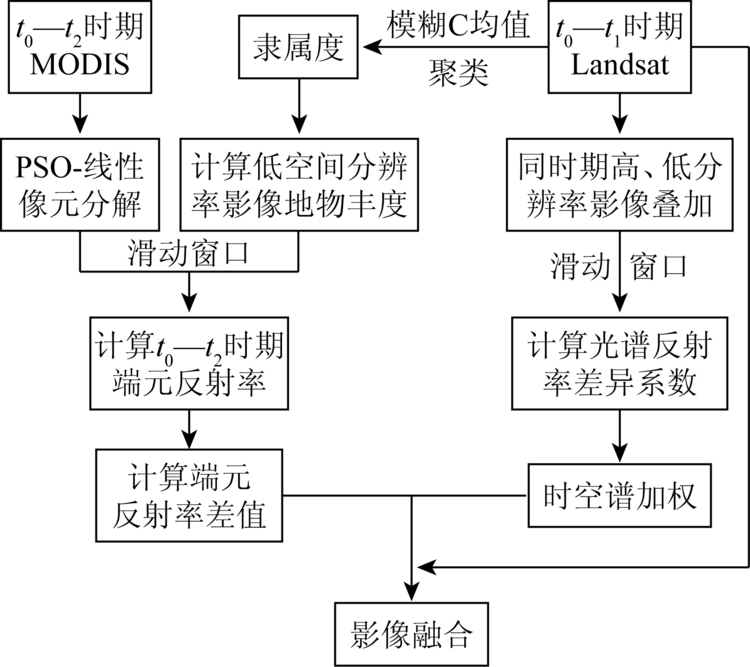
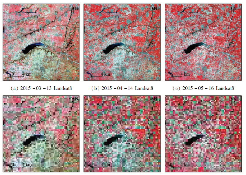
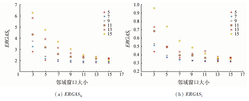
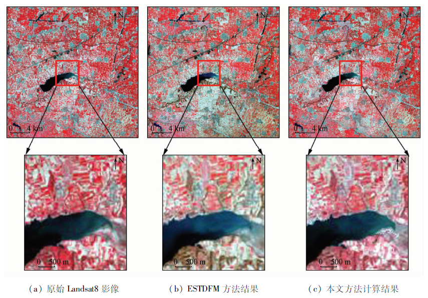
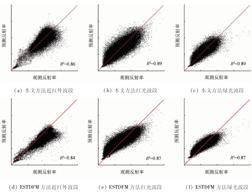
Spatiotemporal fusion image can meet the needs of large-scale, high-precision and rapid change of surface cover monitoring, and hence has been widely used in environmental, hydrological and agricultural monitoring and other fields. In this paper, based on different types of remote sensing data, the authors propose a method of remote sensing image fusion based on particle swarm optimization (PSO) and linear mixed pixel decomposition. First of all, the PSO method is applied to the calculation of the end-point reflectance through the statistics of the different range of the end-point reflectance, and then the remote sensing image fusion is realized by considering the difference of the end-point reflectance between the high and low spatial resolution images and the space-time weight. Finally, the comparison with the existing methods shows that the proposed method can effectively improve the accuracy of the prediction image produced by data fusion. The root mean square error and spatial structure similarity index predicted in this paper are better than the results of the enhanced spatial and temporal data fusion model(ESTDFM). Therefore, the proposed method would be of great value for the study of land cover change monitoring.
张红利, 罗蔚然, 李艳. 基于粒子群优化和像元分解模型的遥感影像时空融合[J]. 国土资源遥感, 2020, 32(4): 33-40.
ZHANG Hongli, LUO Weiran, LI Yan. Spatiotemporal fusion of remote sensing images based on particle swarm optimization and pixel decomposition. Remote Sensing for Land & Resources, 2020, 32(4): 33-40.
Yang J M, Wu Y, Wei Y X, et al. A model for the fusion of multi-source data to generate high temporal and spatial resolution VI data[J]. Journal of Remote Sensing, 2019,23(5):935-943.
[3]
Gevaert, C M, Garcia-Haro, F J. A comparison of STARFM and an unmixing-based algorithm for Landsat and MODIS data fusion[J]. Remote Sensing of Environment, 2015,156(1):34-44.
Dong W Q, Meng J H. Review of spatiotemporal fusion model of remote sensing data[J]. Remote Sensing for Land and Resources, 2018,30(2):1-11.doi: 10.6046/gtzyyg,2018.02.01.
Yang M, Yang G J, Chen X N, et al. Generation of land surface temperature with high spatial and temporal resolution based on FSDAF method[J]. Remote Sensing for Land and Resources, 2018,30(1):54-62.doi: 10.6046/gtzyyg.2018.01.08.
[6]
Meng J H, Wu B F, Du X, et al. Method to construct high spatial and temporal resolution NDVI dataset-STAVFM[J]. Journal of Remote Sensing, 2011,15(1):44-59.
doi: 10.11834/jrs.20110104
[7]
Alysha D P. MODIS-based change detection for Grizzly Bear habitat mapping in Alberta[J]. Photogrammetric Engineering and Remote Sensing, 2008,74(8):973-985.
doi: 10.14358/PERS.74.8.973
[8]
Ju J, Roy D P. The availability of cloud-free Landsat ETM+ data over the conterminous United States and globally[J]. Remote Sensing of Environment, 2008,112(3):1196-1211.
Huang B, Zhao Y Q. Research status and prospect of spatiotemporal fusion of multi-source satellite remote sensing imagery[J]. Acta Geodaetica et Cartographica Sinica, 2017(10):294-301.
Wei R, Shan J. Spatial and temporal fusion for urban land surface temperature image mapping[J]. Geomatics and Information Science of Wuhan University, 2018,43(3):428-435.
[11]
Marfai M A, Almohammad H, Dey S. Coastal dynamic and shoreline mapping:Multi-sources spatial data analysis in Semarang Indonesia[J]. Environmental Monitoring and Assessment, 2008,142(1):297-308.
[12]
Arai E, Shimabukuro Y E, Pereira G. A multi-resoluticm multi-temporal technique for detecting and mapping deforestation in the Brazilian Amazon rainforest[J]. Remote Sensing, 2011,3(9):1943-1956.
[13]
Huang B, Zhang H. Spatio-temporal reflectance fusion via unmixing:Accounting for both phenological and land-cover changes[J]. International Journal of Remote Sensing, 2014,35(16):6213-6233.
[14]
Song H, Huang B. Spatiotemporal satellite image fusion through one-pair image learning[J]. IEEE Transactions on Geoscience and Remote Sensing, 2013,51(4):1883-1896.
[15]
Gao F, Masek J, Schwaller M. On the blending of the Landsat and MODIS surface reflectance:Predicting daily Landsat surface reflectance[J]. IEEE Transactions on Geoscience and Remote Sensing, 2006,44(8):2207-2218.
doi: 10.1109/TGRS.2006.872081
[16]
Hilker T, Wulder M A, Coops N C. A new data fusion model for high spatial-and temporal-resolution mapping of forest disturbance based on Landsat and MODIS[J]. Remote Sensing of Environment, 2009,113(8):1613-1627.
doi: 10.1016/j.rse.2009.03.007
[17]
Zhu X L, Chen J, Gao F. An enhanced spatial and temporal adaptive reflectance fusion model for complex heterogeneous regions[J]. Remote Sensing of Environment, 2010,114(11):2610-2623.
doi: 10.1016/j.rse.2010.05.032
[18]
Zurita-Milla R, Clevers J, Schaepman M E. Unmixing-based Landsat TM and MERIS FR data fusion[J]. IEEE Geoscience and Remote Sensing Letters, 2008,5(3):453-457.
[19]
Maselli F. Definition of spatially variable spectral endmembers by locally calibrated multivariate regression analyses[J]. Remote Sensing of Environment, 2001,75(1):29-38.
[20]
Busetto L, Meroni M, Colombo R. Combining medium and coarse spatial resolution satellite data to improve the estimation of sub-pixel NDVI time series[J]. Remote Sensing of Environment, 2008,112(1):118-131.
[21]
Zhang W, Li A N, Jin H A. An enhanced spatial and temporal data fusion model for fusing Landsat and MODIS surface reflectance to generate high temporal Landsat-like data[J]. Remote Sensing, 2013,5(10):5346-5368.
doi: 10.3390/rs5105346
Zhang B, Sun X, Gao L R, et al. A method of endmember extraction in hyperspectral remote sensing images based on discrete particle swarm optimization[J]. Spectroscopy and Spectral Analysis, 2011,31(9):2455-2461.
doi: 10.3964/j.issn.1000-0593(2011)09-2455-07
[23]
Hadhoud M M, Dessouky M I, El-Samie F E A, et al. Adaptive image interpolation based on local activity levels[C]// Proceedings of the Twentieth National Radio Science Conference. IEEE, 2003:C4-1.
[24]
Wald L. Data fusion,definitions and architectures:Fusion of images of different spatial resolutions[M]. Pressesdes MINES, 2002.
[25]
Zhu X L, Helmer E H, Gao F. A flexible spatiotemporal method for fusing satellite images with different resolutions[J]. Remote Sensing of Environment, 2016,172(1):165-177.
 2020, Vol. 32
  ), 罗蔚然2(