The evaluation of FY-3C snow products in the Tibetan Plateau
MIN Wenbin1(), PEN Jun1, Li Shiying2
1. Institute of Plateau Meteorology, CMA /Heavy Rain and Drought-Flood Disasters in Plateau and Basin Key Laboratory of Sichuan Province, Chengdu 610071, China 2. Sichuan Meteorological Sounding Data Center, Chengdu 610071, China
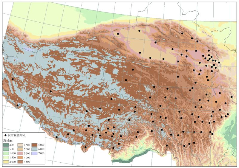
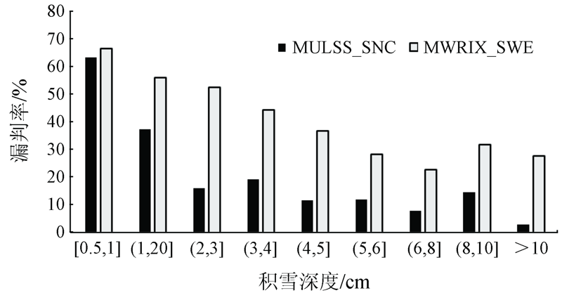
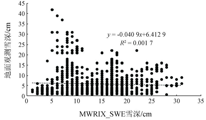
In order to understand the regional reliability of the Fengyun-3C(FY-3C) satellite snow products, the authors used the snow cover data of 118 meteorological stations in the Tibetan Plateau from October 1, 2018 to April 30, 2019 to evaluate the snow cover (MULSS_SNC) and snow water equivalent (MWRIX_SWE) products. The results show that, for snow cover pixels of MULSS_SNC and MWRIX_SWE, the accuracy rate is 87.18% and 72.32% respectively, the recall rate is 66.67% and 49.63% respectively, the false rate is 12.81% and 27.68% respectively, and the missing rate is 33.33% and 50.37% respectively. In terms of mixed pixels or pixels with snow depth less than 0.5 cm, both MULSS_SNC and MWRIX_SWE tend to identify with no snow, and the missing rate of snow depth less than 1cm is up to 60%. When the snow depth of MULSS_SNC is more than 2cm, the recall rate can reach 89.09%. However, for MWRIX_SWE, only when the snow depth is more than 5cm can the snow recall rate reach 63.37%. The snow depth in the Tibetan Plateau from MWRIX_SWE has a large error with ground observations, and there is no linear positive correlation, so it is not recommended to use it directly.
闵文彬, 彭骏, 李施颖. 青藏高原FY-3C卫星积雪产品评估[J]. 国土资源遥感, 2021, 33(1): 145-151.
MIN Wenbin, PEN Jun, Li Shiying. The evaluation of FY-3C snow products in the Tibetan Plateau. Remote Sensing for Land & Resources, 2021, 33(1): 145-151.
Li Z, Zhang W Y, Sun W X. Extracting the information of snow-cover from NOAA/AVHRR data and overlaying with vector data[J]. Remote Sensing Technology and Application, 1995,10(4):19-24.
Yan H, Zhang G P. Unmixing method applied to NOAA/AVHRR data for snow cover estimation[J]. Journal of Applied Meteorological Science, 2004,15(6):665-671.
Liang T G, Wu C X, Chen Q G, et al. Snow classification and monitoring models in the pastoral areas of the Northern Xinjiang[J]. Journal of Glaciology and Geocryology, 2004,26(2):160-165.
Zhang Y H, Ren W, Cao T, et al. Method of snow multi-threshold comprehensive discrimination with FY-3/VIRR data[J]. Remote Sensing Technology and Application, 2015,30(6):1076-1084.
Chen W Q, Ding J L, Sun Y M, et al. Retrieval of snow cover area based on NDSI-NDVI feature space[J]. Journal of Glaciology and Geocryology, 2015,37(4):1059-1066.
Pang H Y, Kong X S, Wang L L, et al. A study of the extraction of snow cover using nonlinear ENDSI model[J]. Remote Sensing for Land and Resources, 2018,30(1):63-71.doi: 10.6046/gtzyyg.2018.01.09.
Wang G X, Jiang L M, Wu S L, et al. Intercalibrating FY-3B and FY-3C/MWRI for synergistic implementing to snow depth retrieval algorithm[J]. Remote Sensing Technology and Application, 2017,32(1):49-56.
Li C C, Xu X, Bao A M, et al. The study on snow depth retrieval in Xinjiang region based on FY3B-MWRI data[J]. Remote Sensing Technology and Application, 2018,33(6):1030-1036.
Sayran W L, Mao W Y. A research on the method of deriving high-precision snow parameters from AMSR2 passive microwave remote sensing data[J]. Journal of Glaciology and Geocryology, 2016,38(1):145-158.
Chen H, Che T, Dai L Y. Snow identification algorithm based on FY-MWRI in Western China[J]. Remote Sensing Technology and Application, 2018,33(6):1037-1045.
[11]
文军, Dai Mo, Deroin Jean-Paul, 等. 利用MODIS和ASAR资料估算青藏高原念青唐古拉山脉地区冰雪范围及厚度[J]. 冰川冻土, 2006,28(1):54-61.
Wen J, Dai M, Deroin J P, et al. Extent and depth of snow cover over the Nyainqêntanglha Range derived from ASAR and MODIS data[J]. Journal of Glaciology and Geocryology, 2006,28(1):54-61.
Sun Y H, Huang X D, Wang W, et al. Spatio-temporal changes of snow cover and snow water equivalent in the Tibetan Plateau during 2003-2010[J]. Journal of Glaciology and Geocryology, 2014,36(6):1337-1344.
Chu D, Da W, Laba Z M, et al. An analysis of spatial-temporal distribution features of snow cover over the Tibetan Plateau based on MODIS data[J]. Remote Sensing for Land and Resources, 2017,29(2):117-124.doi: 10.6046/gtzyyg.2017.02.17.
[14]
Wang X W, Xie H J, Liang T G, et al. Comparison and validation of MODIS standard and new combination of Terra and Aqua snow cover products in Northern Xinjiang,China[J]. Hydrological Processes, 2009,23(3):419-429.
Bo Y C, Feng X Z, Li X, et al. The retrieval of snow depth in Qinghai-Xizang (Tibet) Plateau from passive microwave remote sensing data and its results assessment[J]. Journal of Remote Sensing, 2001,5(3):161-165.
Xiao X X, Zhang T J. Passive microwave remote sensing of snow depth and snow water equivalent:Overview[J]. Advances in Earth Science, 2018,33(6):590-605.
Jiang H B, Qin Q M, Zhang N, et al. Effect of different snow depth and area on the snow cover retrieval using remote sensing data[J]. Spectroscopy and Spectral Analysis, 2011,31(12):3342-3346.
pmid: 22295791
Jin R, Li X, Ma M G, et al. Key methods and experiment verification for the validation of quantitative remote sensing products[J]. Advances in Earth Science, 2017,32(6):630-642.
Wang X, Hao X H, Wang J, et al. Accuracy evaluation of long time series AVHRR snow cover area products in China[J]. Remote Sensing Technology and Application, 2018,33(6):994-1003.
Hou X G, Zheng Z J, Li S, et al. Generation of daily cloudless snow cover product in the past 15 years in Xinjiang and accuracy validation[J]. Remote Sensing for Land and Resources, 2018,30(2):214-222.doi: 10.6046/gtzyyg.2018.02.29.
 2021, Vol. 33
  ), 彭骏1, 李施颖2