Vegetation phenology reflects the interactions between the physiological and ecological processes of vegetation and environmental changes and thus it is practically significant to research and develop the software used to extract the vegetation phenological information based on time series remote sensing data. The existing pieces of software mainly include those developed by foreign R&D staff based on specific remote sensing data. They integrate different methods for data smoothing and reconstruction and serve different users. The analysis and comparison of the functions and characteristics of the existing pieces of software will assist users to select more targeted software and can also provide references for the R&D of the software for vegetation phenology monitoring. This paper first briefly introduces the monitoring principles of vegetation phenological information using remote sensing data and commonly used data smoothing methods for the reconstruction of time series remote sensing data. Then it summarizes multiple pieces of professional software for vegetation phenology monitoring that integrate the reconstruction methods and phenological information extraction methods. Most especially, it introduces the software TIMESAT, SPIRITS, and DATimeS in detail and compares and analyzes their functions and characteristics. Finally, it puts forward the prospect of developing localization application software with user-friendly graphical user interfaces according to the development of remote sensing big data and the demand for vegetation phenology monitoring.
钞振华, 车明亮, 侯胜芳. 基于时间序列遥感数据植被物候信息提取软件发展现状[J]. 自然资源遥感, 2021, 33(4): 19-25.
CHAO Zhenhua, CHE Mingliang, HOU Shengfang. Brief review of vegetation phenological information extraction software based on time series remote sensing data. Remote Sensing for Natural Resources, 2021, 33(4): 19-25.
Zhao Z M, Meng Y, Yue A Z, et al. Review of remotely sensed time series data for change detection[J]. Journal of Remote Sensing, 2016,20(5):1110-1125.
[3]
Hufkens K, Basler D, Milliman T, et al. An integrated phenology modelling framework in R[J]. Methods in Ecology and Evolution, 2018,9:1276-1285.
doi: 10.1111/mee3.2018.9.issue-5
[4]
Frantz D. Force-Landsat+Sentinel-2 analysis ready data and beyond[J]. Remote Sensing, 2019,11:1124.
doi: 10.3390/rs11091124
[5]
Chao Z, Liu N, Zhang P, et al. Estimation methods developing with remote sensing information for energy crop biomass:A comparative review[J]. Biomass and Bioenergy, 2019,122:414-425.
doi: 10.1016/j.biombioe.2019.02.002
Wan C J, Wu X D, Lin X W. Impact of spatial and temporal scales of remote sensing data on the spatiotemporal change in geographic elements[J]. Journal of Remote Sensing, 2019,23(6):1064-1077.
[7]
Dong Y, Peng C. Principled missing data methods for researchers[J]. SpringerPlus, 2013,2(1):1-17.
doi: 10.1186/2193-1801-2-1
[8]
Moreno-Martínez Á, Izquierdo-Verdiguier E, Maneta M P, et al. Multispectral high resolution sensor fusion for smoothing and gap-filling in the cloud[J]. Remote Sensing of Environment, 2020,247:111901.
doi: 10.1016/j.rse.2020.111901
pmid: 32943798
[9]
Chao Z, Wang L, Che M, et al. Effects of different urbanization levels on land surface temperature change:Taking Tokyo and Shanghai for example[J]. Remote Sensing, 2020,12:2022.
doi: 10.3390/rs12122022
[10]
Zeng L, Wardlow B, Xiang D, et al. A review of vegetation phenological metrics extraction using time-series,multispectral satellite data[J]. Remote Sensing of Environment, 2020,237:111511.
doi: 10.1016/j.rse.2019.111511
[11]
Smith W, Dannenberg M, Yan D, et al. Remote sensing of dryland ecosystem structure and function:Progress,challenges,and opportunities[J]. Remote Sensing of Environment, 2019,233:111401.
doi: 10.1016/j.rse.2019.111401
[12]
Chen J, Boccelli D. Real-time forecasting and visualization toolkit for multi-seasonal time series[J]. Environmental Modelling and Software, 2018,105:244-256.
doi: 10.1016/j.envsoft.2018.03.034
[13]
Jönsson P, Cai Z, Melaas E, et al. A method for robust estimation of vegetation seasonality from Landsat and Sentinel-2 time series data[J]. Remote Sensing, 2018,10(4):635.
doi: 10.3390/rs10040635
[14]
Jönsson P, Eklundh L. TIMESAT:A program for analyzing time-series of satellite sensor data[J]. Computers and Geosciences, 2004,30:833-845.
doi: 10.1016/j.cageo.2004.05.006
[15]
Verbesselt J, Hyndman R, Newnham G, et al. Detecting trend and seasonal changes in satellite image time series[J]. Remote Sensing of Environment, 2010,114:106-115.
doi: 10.1016/j.rse.2009.08.014
[16]
Udelhoven T. Timestats:A software tool for the retrieval of temporal patterns from global satellite archives[J]. IEEE Journal of Selected Topics in Applied Earth Observations and Remote Sensing, 2011,4:310-317.
doi: 10.1109/JSTARS.4609443
[17]
Eerens H, Haesen D, Rembold F, et al. Image time series processing for agriculture monitoring[J]. Environmental Modelling and Software, 2014,53:154-162.
doi: 10.1016/j.envsoft.2013.10.021
[18]
Arundel J, Winter S, Gui G, et al. A web-based application for beekeepers to visualise patterns of growth in floral resources using MODIS data[J]. Environmental Modelling and Software, 2016,83:116-125.
doi: 10.1016/j.envsoft.2016.05.010
[19]
Taylor S. pyPhenology:A python framework for plant phenology modelling[J]. Journal of Open Source Software, 2018,3(28):827.
doi: 10.21105/joss
[20]
Araya S, Ostendorf B, Lyle G, et al. CropPhenology:An R package for extracting crop phenology from time series remotely sensed vegetation index imagery[J]. Ecological Informatics, 2018,46:45-56.
doi: 10.1016/j.ecoinf.2018.05.006
[21]
Li H, Wan W, Fang Y, et al. A Google Earth Engine-enabled software for efficiently generating high-quality user-ready Landsat mosaic images[J]. Environmental Modelling and Software, 2019,112:16-22.
doi: 10.1016/j.envsoft.2018.11.004
[22]
Jakimow B, van der Linden S, Thiel F, et al. Visualizing and labeling dense multi-sensor earth observation time series:The EO time series viewer[J]. Environmental Modelling and Software, 2020,125:104631.
doi: 10.1016/j.envsoft.2020.104631
[23]
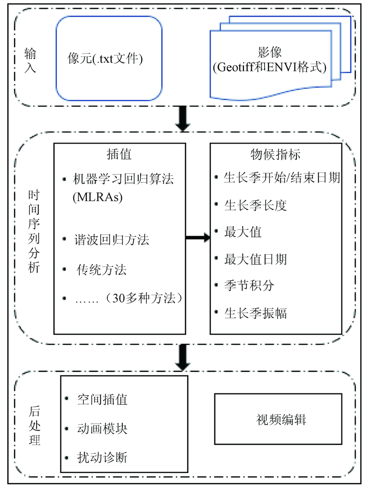
Belda S, Pipia L, Morcillo-Pallarés P, et al. DATimeS:A machine learning time series GUI toolbox for gap-filling and vegetation phenology trends detection[J]. Environmental Modelling and Software, 2020,127:104666.
doi: 10.1016/j.envsoft.2020.104666
[24]
Dragoni D, Schmid H, Wayson C, et al. Evidence of increased net ecosystem productivity associated with a longer vegetated season in a deciduous forest in southcentral Indiana,USA[J]. Global Change Biology, 2011,17(2):886-897.
doi: 10.1111/gcb.2010.17.issue-2
[25]
White M, De Beurs K, Didan K, et al. Intercomparison,interpretation,and assessment of spring phenology in North America estimated from remote sensing for 1982 to 2006[J]. Global Change Biology, 2009,15:2335-2359.
doi: 10.1111/gcb.2009.15.issue-10
[26]
Julien Y, Sobrino J. Global land surface phenology trends from GIMMS database[J]. International Journal of Remote Sensing, 2009,30:3495-3513.
doi: 10.1080/01431160802562255
[27]
Tan B, Morisette J, Wolfe R, et al. An enhanced TIMESAT algorithm for estimating vegetation phenology metrics from MODIS data[J]. IEEE Journal of Selected Topics in Applied Earth Observations and Remote Sensing, 2011,4:361-371.
doi: 10.1109/JSTARS.4609443
[28]
Broich M, Huete A, Paget M, et al. A spatially explicit land surface phenology data product for science,monitoring and natural resources management applications[J]. Environmental Modelling and Software, 2015,64:191-204.
doi: 10.1016/j.envsoft.2014.11.017
[29]
Berra E, Gaulton R, Barr S. Assessing spring phenology of a temperate woodland:A multiscale comparison of ground,unmanned aerial vehicle and Landsat satellite observations[J]. Remote Sensing of Environment, 2019,223:229-242.
doi: 10.1016/j.rse.2019.01.010
[30]
Zhao K, Wulder M, Hu T, et al. Detecting change-point,trend,and seasonality in satellite time series data to track abrupt changes and nonlinear dynamics:A Bayesian ensemble algorithm[J]. Remote Sensing of Environment, 2019,232:111181.
doi: 10.1016/j.rse.2019.04.034
[31]
Belda S, Pipia L, Morcillo-Pallarés P, et al. Optimizing Gaussian process regression for image time series gap-filling and crop monitoring[J]. Agronomy, 2020,10:618.
doi: 10.3390/agronomy10050618
[32]
Verrelst J, Malenovský Z, Van der Tol C, et al. Quantifying vegetation biophysical variables from imaging spectroscopy data:A review on retrieval method[J]. Surveys in Geophysics, 2019,40:589-629.
doi: 10.1007/s10712-018-9478-y
[33]
Reichstein M, Campas-Valls G, Stevens B, et al. Deep learning and process understanding for data driven Earth system science[J]. Nature, 2019,566:195-204.
doi: 10.1038/s41586-019-0912-1
Cao P Y, Zhang L M, Li S G, et al. Review on vegetation phenology observation and phenological index extraction[J]. Advanced Earth Science, 2016,31(4):365-376.
 2021, Vol. 33
  ), 车明亮(