River and lake sand mining in the Dongting Lake area: Supervision based on high-resolution remote sensing images and typical case analysis
TANG Hui1,2,3(), ZOU Juan1,2,3, YIN Xianghong1, YU Shuchen1,2,3, HE Qiuhua1,2,3, ZHAO Dong1, ZOU Cong1, LUO Jianqiang1,2,3
1. Hunan Center of Natural Resources Affairs, Changsha 410004, China 2. Hunan Provincial Key Laboratory of Remote Sensing Monitoring of Ecological Environment in Dongting Lake Area, Changsha 410004, China 3. Dongting Lake Basin Ecological Protection and Restoration Engineering Technology Innovation Center, Ministry of Natural Resources, Changsha 410004, China
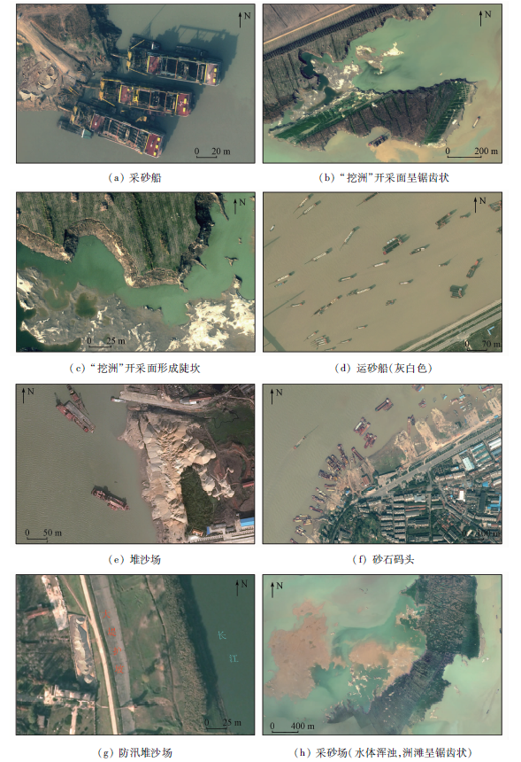
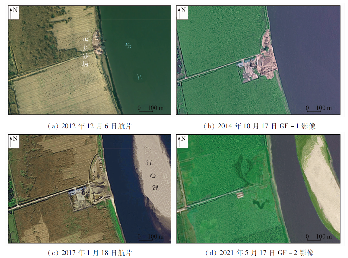
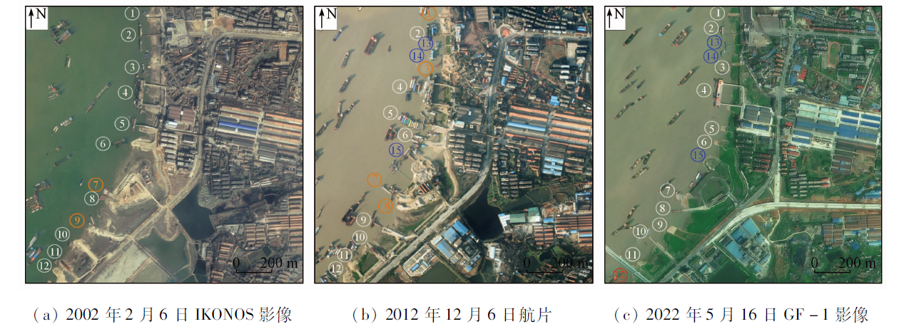
This study aims to investigate the application of high-resolution remote sensing images in the supervision of river and lake sand mining in the Dongting Lake area. Based on the aerial and space high-resolution remote sensing images over the past 20 years, as well as human-computer interaction interpretation and field investigation verification, this study summarized the types and meanings of surface elements in river and lake sand mining, established the remote sensing interpretation symbols for river and lake sand mining, and analyzed representative typical cases. The results show that the interpretation symbols of remote sensing images for river and lake sand mining differ from those for onshore mining summarized previously. The river and lake sand mining was carried out using dredges as the mining equipment, sand carriers as the transport equipment, and sand yards and docks as transfer sites. The mining surfaces caused serrated bank lines during sandbar digging. Furthermore, surface cover changed near mining areas, including turbid water and shrinkage of sandbars and shoals. This study analyzed three typical cases, namely the evolution of the Hualong sand yard, the treatment of the Chenglingji wharf, and the illegal sand mining in Piaoweizhou of the eastern Dongting Lake. The analytical results indicate that high-resolution remote sensing can provide technical support for supervising river and lake sand mining.
唐晖, 邹娟, 尹向红, 余姝辰, 贺秋华, 赵动, 邹聪, 罗建强. 基于高分遥感的洞庭湖区河湖采砂监管及典型案例分析[J]. 自然资源遥感, 2023, 35(3): 302-309.
TANG Hui, ZOU Juan, YIN Xianghong, YU Shuchen, HE Qiuhua, ZHAO Dong, ZOU Cong, LUO Jianqiang. River and lake sand mining in the Dongting Lake area: Supervision based on high-resolution remote sensing images and typical case analysis. Remote Sensing for Natural Resources, 2023, 35(3): 302-309.
Yu S C, Yu D Q, Wang L C, et al. Remote sensing study of Dongting Lake beach changes before and after operation of Three Gorges Reservoir[J]. Earth Science, 2019, 44(12):4275-4283.
Jiang J Y, Zhong Y H. Practice and reflection on sand mining management in river channels in Hunan Province[J]. Hunan Hydro and Power, 2020(3):106-108.
[3]
湖南省水利厅. 湖南重拳整治洞庭湖非法采砂[J]. 湖南水利水电, 2017(6):116.
Hunan Provincial Department of Water Resources. Hunan cracks down on illegal sand mining in Dongting Lake[J]. Hunan Hydro and Power, 2017(6):116.
Zou J, Liu Z L, Zhang Y Z, et al. Remote sensing monitoring and analysis of mining development in Dongting Lake ecological economic zone (Hunan Part)[J]. Shanxi Metallurgy, 2022, 45(5):71-74.
Yin Y Q, Jiang C H, Ju X, et al. Remote sensing evaluation of mine geological environment of Hainan Island in 2018 and ecological restoration countermeasures[J]. Remote Sensing for Natural Resources, 2022, 34(2):194-202.doi: 10.6046/zrzyyg.2021136.
doi: 10.6046/zrzyyg.2021136
Zhang X, Li W, Chen L, et al. Research progress and prospect of remote sensing extraction of elements in opencast mining area[J]. Remote Sensing for Natural Resources, 2023, 35(2):25-33.doi:10.6046/zrzyyg.2022141.
doi: 10.6046/zrzyyg.2022141
Yang X H, Wei P, Lyu J, et al. Application of mining collapse reco-gnition technology based on multi-source remote sensing[J]. Remote Sensing for Natural Resources, 2022, 34(2):162-167.doi: 10.6046/zrzyyg.2021195.
doi: 10.6046/zrzyyg.2021195
Yu H, An N, Wang J, et al. High resolution remote sensing dynamic monitoring of coal mining subsidence area in Southwest Guizhou: A case study of coal mine goaf subsidence area in Liupanshui[J]. Remote Sensing for Natural Resource, 2023, 35(3):310-318.doi:10.6046/zrzyyg.2022170.
doi: 10.6046/zrzyyg.2022170
Yang J Z, Qin X W, Nie H F, et al. Comprehensive research on remote sensing monitoring of the national concentration zones of the important mine[J]. Geological Survey of China, 2015(4):24-30.
[10]
秦绪文, 杨金中. 中国矿山遥感监测[M]. 北京: 测绘出版社, 2014.
Qin X W, Yang J Z. Remote sensing monitoring of mines in China[M]. Beijing: Surveying and Mapping Publishing House, 2014.
Liu L, Li C A, Gao J H, et al. Spatiotemporal changes of illegal mining in Hunan mines based on multi-source satellite remote sensing[J]. National Remote Sensing Bulletin, 2022, 26(3):528-540.
doi: 10.11834/jrs.20219284
Cui Q, Chen D Q. Typical case analysis of river and lake supervision supported by remote sensing technology[J]. Water Resources Information, 2020(2):9-13.
Suo R. Application of UAV surveying and mapping technology in river sand mining supervision[J]. Heilongjiang Hydraulic Science and Technology, 2021, 49(11):156-158,202.
Xu X H, Bao X C, Wang H J, et al. Key technologies and applications of intelligent supervision of the whole process of sand mining in rivers and lakes[D]. Nanchang: JiangXi Academy of Water Science and Engineering, 2021.
Yu S C, Wang L C, Xia W P, et al. Spatio-temporal evolution of riparian lakes in Dongting Lake area since the late Qing Dynasty[J]. Acta Geographica Sinica, 2020, 75(11):2346-2361.
doi: 10.11821/dlxb202011006
Yu D Q, Yu S C, He Q H, et al. Monitoring of Dongting Lake atrophy in the past 100 years by combining historical map and remote sensing technology[J]. Remote Sensing for Land and Resources, 2016, 28(3): 116-122.doi: 10.6046/gtzyyg.2016.03.19.
doi: 10.6046/gtzyyg.2016.03.19
He Q H, Yu D Q, Yu S C, et al. Changes of water resources amount in Dongting Lake before and after the operation of the Three Gorges Reservoir[J]. Earth Science, 2021, 46(1):293-307.
[19]
水利部长江水利委员会. 长江泥沙公报(2020)[M]. 武汉: 长江出版社, 2021.
Changjiang Water Resources Commission of the Ministry of Water Resource. Changjiang sediment bulletin(2020)[M]. Wuhan: Changjiang Press, 2021.
Yueyang Water Conservancy Bureau. Sand mining planning of main stream of Xiangzi Yuanli and Dongting Lake in Hunan Province (2023—2027)[EB/OL].(2021-11-26)[2023-04-10]. http://slt.hunan.gov.cn/slt/xxgk/zfcg/202111/t20211126_21179095.html.
Guo Z T, Zhang Y Z X. The green transformation of the gravel wharf:“Sky Eye” technology helps Dongting Lake to change its old appearance[N/OL]. Hunan Daily,2022-04-18(B02) [2023-04-10]. https://www.hunantoday.cn/article/202204/202204180915239040.html.
 2023, Vol. 35
  ), 邹娟1,2,3, 尹向红1, 余姝辰1,2,3, 贺秋华1,2,3, 赵动1, 邹聪1, 罗建强1,2,3