Identifying predominant tree species based on airborne hyperspectral images using machine learning algorithms
YU Hang1,2(), TAN Bingxiang1,2(), SHEN Mingtan1,2, HE Chenrui1,2, HUANG Yifei1,2
1. Research Institute of Forest Resources Information Techniques, Chinese Academy of Forestry, Beijing 100091, China 2. Key Laboratory of Forestry Remote Sensing and Information System, NFGA, Beijing 100091, China
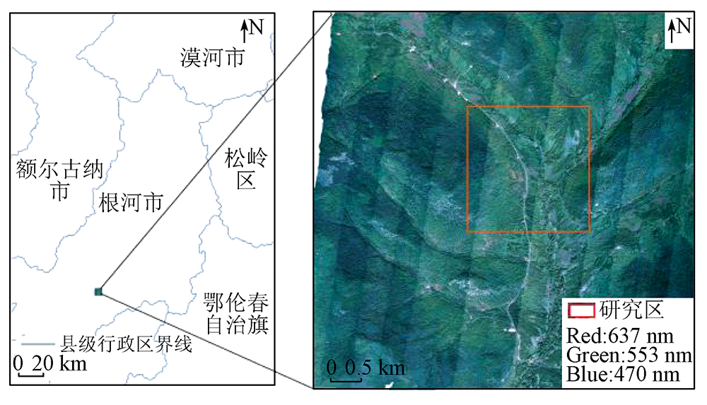
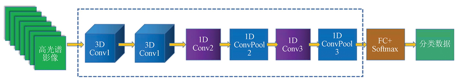
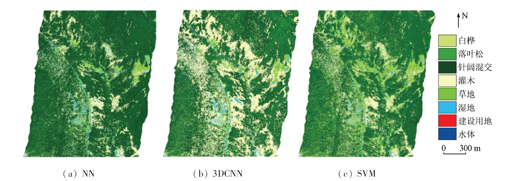
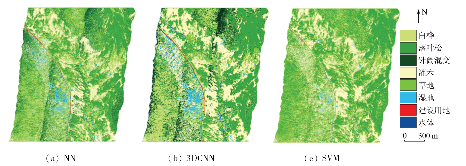
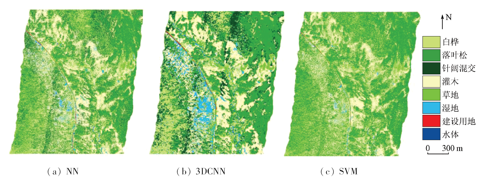
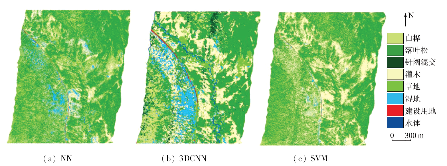
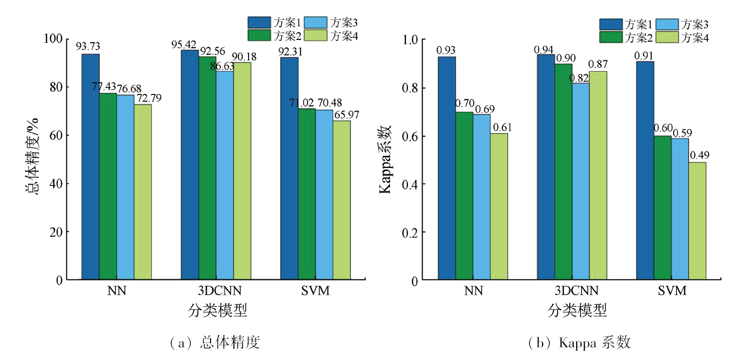
Identifying forest tree species can provide a valuable scientific reference for ascertaining forest resources. However, it is difficult to achieve accurate tree species classification even using hyperspectral data with high spatial resolution. Hence, there is an urgent need to meet this challenge. This study investigated the Genhe Forest Reserve in the Great Xing’an Range within Inner Mongolia. At spatial resolutions of 1 m and 3 m, two sample value scales were employed: sample points (i.e., the spectral values of pixels corresponding to sample plots) and sample planes (i.e., the average spectral values of pixels in a 3×3 window corresponding to sample plots). Then, this study explored the identification effects of predominant tree species using airborne hyperspectral images based on three machine learning algorithms: neural network (NN), three-dimensional convolution neural network (3DCNN), and support vector machine (SVM). Key findings include: ① Regardless of spatial resolution and sample value scales, the 3DCNN exhibited the highest classification accuracy, yielding the highest overall accuracy and Kappa coefficient of 95.42% and 0.94, respectively; ② Compared to a low spatial resolution (3 m), a high spatial resolution was more favorable to the identification of predominant tree species, with overall accuracy and Kappa coefficient increased by 30.97% and 54.24% at most, respectively; ③ In the case of NN/SVM-based classification, sample points outperformed sample planes in improving the accuracy of tree species identification. In contrast, sample planes outperformed sample points for 3DCNN-based classification at a spatial resolution of 3 m. Overall, spatial resolution, sample value scales, and classification algorithms manifested varying degrees of effects on the identification accuracy of predominant tree species. High-spatial-resolution images, small-sample data, and deep-learning algorithms can be combined to enhance the accuracy of predominant tree species identification using airborne hyperspectral images.
Song Q F. Study on impact of forest resource dynamic change on forest ecological function in recent 40 years in China[D]. Beijing: Chinese Academy of Forestry, 2015.
[2]
Nagendra H, Lucas R, Honrado J P, et al. Remote sensing for conservation monitoring:Assessing protected areas,habitat extent,habitat condition,species diversity,and threats[J]. Ecological Indicators, 2013, 33:45-59.
doi: 10.1016/j.ecolind.2012.09.014
[3]
Thomas S C, Malczewski G. Wood carbon content of tree species in Eastern China:Interspecific variability and the importance of the volatile fraction[J]. Journal of Environmental Management, 2007, 85(3):659-662.
pmid: 17187921
[4]
Ashutosh S. Monitoring forests:A new paradigm of remote sensing & GIS based change detection[J]. Journal of Geographic Information System, 2012, 4(5):470-478.
doi: 10.4236/jgis.2012.45051
[5]
Connette G, Oswald P, Songer M, et al. Mapping distinct forest types improves overall forest identification based on multi-spectral Landsat imagery for Myanmar’s Tanintharyi Region[J]. Remote Sensing, 2016, 8(11):882.
doi: 10.3390/rs8110882
Liao J L, Zhang L, Zhou X S, et al. A hyperspectral image vegetation classification method using 2D-3D CNNs and vegetation index[J]. Science Technology and Engineering, 2021, 21(27):11656-11662.
[7]
Wang Z S, Zou C, Cai W W. Small sample classification of hyperspectral remote sensing images based on sequential joint deeping learning model[J]. IEEE Access, 2020, 8:71353-71363.
doi: 10.1109/Access.6287639
Tan B X, Li Z Y, Chen E X, et al. Research advance in forest information extraction from hyoerspectral remote sensing data[J]. Forest Research, 2008, 21(s1):105-111.
Wang H J, Tan B X, Fang X F, et al. Precise classification of forest types use Hyperion image based on the C5.0 decision tree algorithm[J]. Journal of Zhejiang A & F University, 2018, 35(4):724-734.
[10]
Miyoshi G T, Arruda M S, Osco L P, et al. A novel deep learning method to identify single tree species in UAV-based hyperspectral images[J]. Remote Sensing, 2020, 12(8):1294.
doi: 10.3390/rs12081294
He X Y, Ren C Y, Chen L, et al. The progress of forest ecosystems monitoring with remote sensing techniques[J]. Scientia Geographica Sinica, 2018, 38(7):997-1011.
doi: 10.13249/j.cnki.sgs.2018.07.001
[12]
Dalponte M, Ørka H O, Gobakken T, et al. Tree species classification in boreal forests with hyperspectral data[J]. IEEE Transactions on Geoscience and Remote Sensing, 2013, 51(5):2632-2645.
doi: 10.1109/TGRS.2012.2216272
[13]
Suess S, Van der Linden S, Okujeni A, et al. Using class probabilities to map gradual transitions in shrub vegetation from simulated EnMAP data[J]. Remote Sensing, 2015, 7(8):10668-10688.
doi: 10.3390/rs70810668
[14]
Ghosh A, Fassnacht F E, Joshi P K, et al. A framework for mapping tree species combining hyperspectral and LiDAR data:Role of selected classifiers and sensor across three spatial scales[J]. International Journal of Applied Earth Observation and Geoinformation, 2014, 26:49-63.
doi: 10.1016/j.jag.2013.05.017
[15]
Ali I, Greifeneder F, Stamenkovic J, et al. Review of machine learning approaches for biomass and soil moisture retrievals from remote sensing data[J]. Remote Sensing, 2015, 7(12):16398-16421.
doi: 10.3390/rs71215841
[16]
Petropoulos G P, Kontoes C C, Keramitsoglou I. Land cover mapping with emphasis to burnt area delineation using co-orbital ALI and Landsat TM imagery[J]. International Journal of Applied Earth Observation and Geoinformation, 2012, 18:344-355.
doi: 10.1016/j.jag.2012.02.004
Zhang X N, Zhong X, Zhu R F, et al. Scene classification of remote sensing images based onintegrated convolutional neural networks[J]. Acta Optica Sinica, 2018, 38(11):350-360.
[18]
Sothe C, La Rosa L E C, De Almeida C M, et al. Evaluating a convolutional neural network for feature extraction and tree species classification using uav-hyperspectral images[J]. ISPRS Annals of the Photogrammetry,Remote Sensing and Spatial Information Sciences, 2020:193-199.
[19]
Mäyrä J, Keski-Saari S, Kivinen S, et al. Tree species classification from airborne hyperspectral and LiDAR data using 3D convolutional neural networks[J]. Remote Sensing of Environment, 2021, 256:112322.
doi: 10.1016/j.rse.2021.112322
[20]
Becker B L, Lusch D P, Qi J. A classification-based assessment of the optimal spectral and spatial resolutions for Great Lakes coastal wetland imagery[J]. Remote Sensing of Environment, 2007, 108(1):111-120.
doi: 10.1016/j.rse.2006.11.005
[21]
李波. 机载激光点云和高光谱影像融合的城市地物分类研究[D]. 武汉: 武汉大学, 2017.
Li B. Data fusion of aerial LIDAR data and hyperspectral imagery for urban classification[D]. Wuhan: Wuhan University, 2017.
[22]
徐化成. 中国大兴安岭森林[M]. 北京: 科学出版社,1998.
Xu H C. Daxinganling Mountains forests in China[M]. Beijing: Science Press,1998.
Wang Z W, Wang D L. Niche relationships between Betula platyphylla and main understory herbages in forest-steppe ecotone of Daxinganling Mountains[J]. Chinese Journal of Applied Ecology, 2001, 12(5):677-681.
Chen L X, Xiao Y. Evolution and evaluation of soil fertility in forest land in Larix gmelinii plantations at different development stages in Daxinganling forest region[J]. Science of Soil and Water Conservation, 2006, 4(5):50-55.
Zhu B, Wang X H, Tang L L, et al. Review on methods for SNR Estimation of optical remote sensing imagery[J]. Remote Sensing Technology and Application, 2010, 25(2):303-309.
State Forestry Administration. LY/T 2188.1-2013 Technical specification for forest resource data collection[S]. Beijing: China Standards Publishing House, 2014.
[27]
Audebert N, Le Saux B, Lefèvre S. Deep learning for classification of hyperspectral data:A comparative review[J]. IEEE Geoscience and Remote Sensing Magazine, 2019, 7(2):159-173.
doi: 10.1109/MGRS.2019.2912563
[28]
Paoletti M E, Haut J M, Plaza J, et al. Deep learning classifiers for hyperspectral imaging:A review[J]. ISPRS Journal of Photogrammetry and Remote Sensing, 2019, 158:279-317.
doi: 10.1016/j.isprsjprs.2019.09.006
[29]
Hasan M, Ullah S, Khan M J, et al. Comparative analysis of SVM,ANN and CNN for classifying vegetation species using hyperspectral thermal infrared data[J]. The International Archives of the Photogrammetry,Remote Sensing and Spatial Information Sciences, 2019, 42:1861-1868.
[30]
张学工. 关于统计学习理论与支持向量机[J]. 自动化学报, 2000, 26(1):32-42.
Zhang X G. Introduction to statistical learning theory and support vector machines[J]. Acta Automatica Sinica, 2000, 26(1):32-42.
[31]
Nguyen H M, Demir B, Dalponte M. A weighted SVM-based approach to tree species classification at individual tree crown level using LiDAR data[J]. Remote Sensing, 2019, 11(24):2948.
doi: 10.3390/rs11242948
Zheng D, Shen G C, Wang B J, et al. Classification of dominant species in coniferous and broad-leaved mixed forest on Changbai Mountain based on UAV-based hyperspectral image and deep learning algorithm[J]. Chinese Journal of Ecology, 2022, 41(5):1024-1032.
doi: DOI: 10.13292/j.1000-4890.202203.004
[33]
Trier Ø D, Salberg A B, Kermit M, et al. Tree species classification in Norway from airborne hyperspectral and airborne laser scanning data[J]. European Journal of Remote Sensing, 2018, 51(1):336-351.
doi: 10.1080/22797254.2018.1434424
[34]
Nevalainen O, Honkavaara E, Tuominen S, et al. Individual tree detection and classification with UAV-based photogrammetric point clouds and hyperspectral imaging[J]. Remote Sensing, 2017, 9(3):185.
doi: 10.3390/rs9030185
Zhou Z H, Ni H, Ma L F. Improved spectral-spatial convolutional network using continuously spatial dependency enhancement for hyperspectral image classification[J]. Geography and Geo-Information Science, 2021, 37(6):32-40.
Deng L, Deng M J, Zhang L S. Optimization of shadow detection and compensation method for high-resolution remote sensing images[J]. Remote Sensing Technology and Application, 2015, 30(2):277-284.
Jiang J R, Zhu W Q, Qiao K, et al. An identification method for mountains coniferous in Tianshan with Sentinel-2 data[J]. Remote Sensing Technology and Application, 2021, 36(4):847-856.
[38]
Sothe C, De Almeida C M, Schimalski M B, et al. Comparative performance of convolutional neural network,weighted and conventional support vector machine and random forest for classifying tree species using hyperspectral and photogrammetric data[J]. GIScience & Remote Sensing, 2020, 57(3):369-394.
Li H T, Dai L L, Gu H Y, et al. Analysis of sample size influence on FCN training model in remote sensing image[J]. Science of Surveying and Mapping, 2019, 44(6):133-137.
[40]
Fricker G A, Ventura J D, Wolf J A, et al. A convolutional neural network classifier identifies tree species in mixed-conifer forest from hyperspectral imagery[J]. Remote Sensing, 2019, 11(19):2326.
doi: 10.3390/rs11192326
[41]
Hartling S, Sagan V, Sidike P, et al. Urban tree species classification using a WorldView-2/3 and LiDAR data fusion approach and deep learning[J]. Sensors, 2019, 19(6):1284.
doi: 10.3390/s19061284
 2024, Vol. 36
  ), 谭炳香1,2(