Multi-class change detection using a multi-task Siamese network of remote sensing images
MA Hui1(), LIU Bo2(), DU Shihong2
1. Institute of Land Resources Survey and Planning, Henan Province, Zhengzhou 450016, China 2. Institute of Remote Sensing and GIS, Peking University, Beijing 100871, China
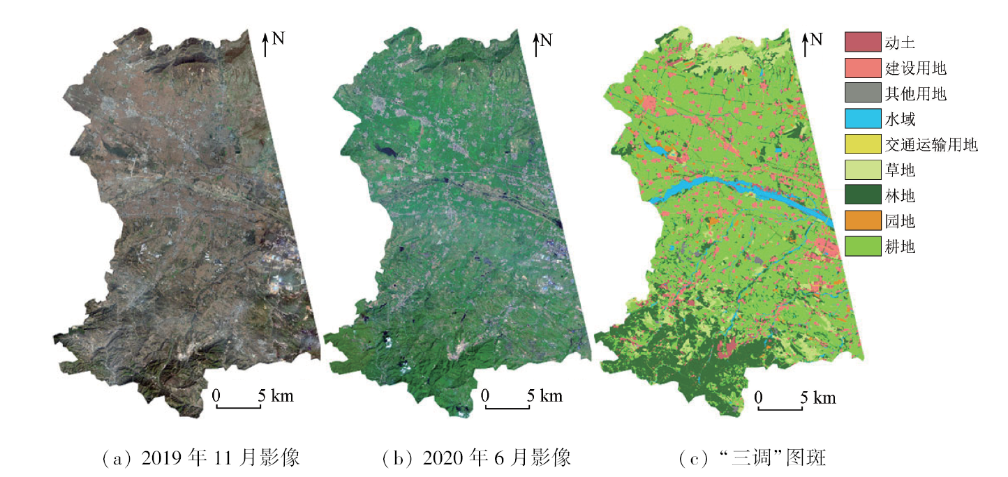
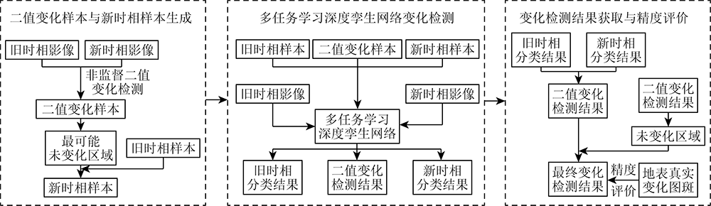
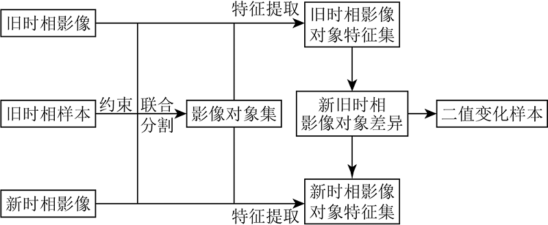
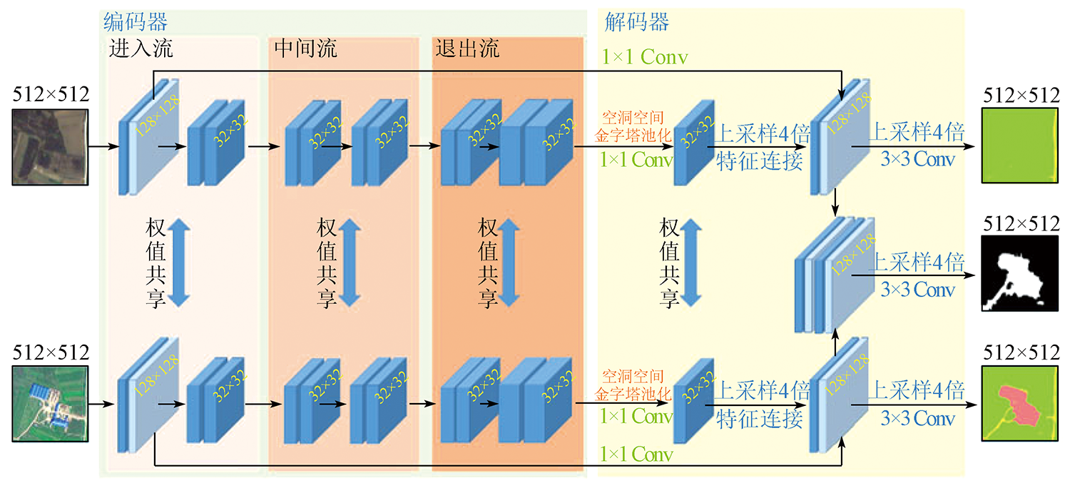
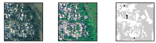
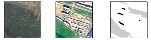
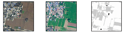
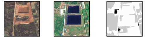
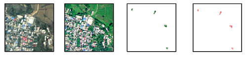
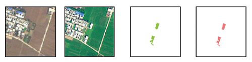
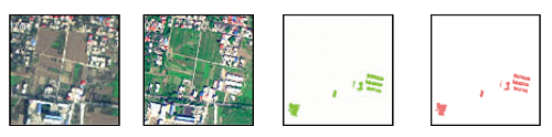
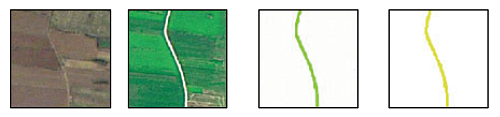
The accurate acquisition of land cover/use changes and their types is critical to territorial space planning, ecological environment monitoring, and disaster assessment. However, most current studies on the change detection focus on binary change detection. This study proposed a multi-class change detection method using a multi-task Siamese network of remote sensing images. First, an object-oriented unsupervised change detection method was employed to select areas that were most/least prone to change in the new and old temporal images. These areas were used as samples for the multi-task Siamese network. Subsequently, the multi-task Siamese network model was used to learn and predict the new and old temporal land-use maps and binary change maps. Finally, the final multi-class change detection results were derived from these maps. The multi-task Siamese network was tested based on the images from the Third National Land Survey and corresponding land-use maps. The results demonstrate that the method proposed in this study is applicable to the change detection cases where changed and unchanged samples lack but there are available historical thematic maps.
马惠, 刘波, 杜世宏. 多任务学习孪生网络的遥感影像多类变化检测[J]. 自然资源遥感, 2024, 36(1): 77-85.
MA Hui, LIU Bo, DU Shihong. Multi-class change detection using a multi-task Siamese network of remote sensing images. Remote Sensing for Natural Resources, 2024, 36(1): 77-85.
Shi W Z, Zhang P L. State-of-the-art remotely sensed images-based change detection methods[J]. Geomatics and Information Science of Wuhan University, 2018, 43(12):1832-1837.
Ren Q R, Yang W Z, Wang C J, et al. Review of remote sensing image change detection[J]. Journal of Computer Applications, 2021, 41(8):2294-2305.
doi: 10.11772/j.issn.1001-9081.2020101632
Yang C J, Ou X K, Dang C L, et al. Detecting the change information of forest vegetation in Lushui County of Yunnan Province[J]. Geo-Information Science, 2000, 2(4):71-74.
[5]
Li P J, Xu H Q. Land-cover change detection using one-class support vector machine[J]. Photogrammetric Engineering and Remote Sensing, 2010, 76(3):255-263.
doi: 10.14358/PERS.76.3.255
[6]
Cao G, Li Y P, Liu Y Z, et al. Automatic change detection in high-resolution remote-sensing images by means of level set evolution and support vector machine classification[J]. International Journal of Remote Sensing, 2014, 35(16):6255-6270.
doi: 10.1080/01431161.2014.951740
[7]
Zhang Z J, Li A N, Lei G B, et al. Change detection of remote sensing images based on multiscale segmentation and decision tree algorithm over mountainous area:A case study in Panxi region,Sichuan Province[J]. Acta Ecologica Sinica, 2014, 34(24):7222-7232.
Huang X J, Xie Y W, Wei J J, et al. Automatic recognition of desertification information based on the pattern of change detection-CART decision tree[J]. Journal of Catastrophology, 2017, 32(1):36-42.
[9]
Seo D K, Kim Y H, Eo Y D, et al. Generation of radiometric,phenological normalized image based on random forest regression for change detection[J]. Remote Sensing, 2017, 9(11):1163.
doi: 10.3390/rs9111163
Feng W Q, Sui H G, Tu J H, et al. Change detection method for high resolution remote sensing images using random forest[J]. Acta Geodaetica et Cartographica Sinica, 2017, 46(11):1880-1890.
doi: 10.11947/j.AGCS.2017.20170074
[11]
Wang Q M, Shi W Z, Atkinson P M, et al. Land cover change detection at subpixel resolution with a hopfield neural network[J]. IEEE Journal of Selected Topics in Applied Earth Observations and Remote Sensing, 2015, 8(3):1339-1352.
doi: 10.1109/JSTARS.4609443
[12]
Cao G, Liu Y Z, Shang Y F. Automatic change detection in remote sensing images using level set method with neighborhood constraints[J]. Journal of Applied Remote Sensing, 2014, 8(1):083678.
doi: 10.1117/1.JRS.8.083678
Yan M, Cao G, Xia M. Automatic change detection of high resolution remote sensing images based on level set evolution and support vector machine classification[J]. Journal of Harbin University of Science and Technology, 2019, 24(1):78-84.
[14]
Bruzzone L, Prieto D F. Automatic analysis of the difference image for unsupervised change detection[J]. IEEE Transactions on Geoscience and Remote Sensing, 2000, 38(3):1171-1182.
doi: 10.1109/36.843009
[15]
Zhou L C, Cao G, Li Y P, et al. Change detection based on conditional random field with region connection constraints in high-resolution remote sensing images[J]. IEEE Journal of Selected Topics in Applied Earth Observations and Remote Sensing, 2016, 9(8):3478-3488.
doi: 10.1109/JSTARS.4609443
Wei L F, Mou Z W, Wang X Y, et al. Change detection of high resolution remote sensing image based on CRF model[J]. Bulletin of Surveying and Mapping, 2017, 9:28-31.
[17]
Weismiller R A, Kristof S J, Scholz D K, et al. Change detection in coastal zone environments[J]. Photogrammetric Engineering and Remote Sensing, 1977, 42(12):1533-1539.
[18]
Malila W A. Change vector analysis:An approach for detecting forest changes with Landsat[J]. Proceedings of the Society of Photo-Optical Instrumentation Engineers, 1980:326-336.
[19]
Jensen J R, Toll D L. Detecting residential land use development at the urban fringe[J]. Photogrammetric Engineering and Remote Sensing, 1982, 48:629-643.
[20]
Byrne G F, Crapper P F, Mayo K K. Monitoring land cover change by principal component analysis of multitemporal Landsat data[J]. Remote Sensing of Environment, 1980, 10(3):175-184.
doi: 10.1016/0034-4257(80)90021-8
[21]
Ingebritsen S E, Lyon R J P. Principal components analysis of multitemporal image pairs[J]. International Journal of Remote Sensing, 1985, 6(5):687-696.
doi: 10.1080/01431168508948491
Wu H P, Wen L, Deng K, et al. Deep learning based change detection for high-resolution remote sensing images[J]. Geomatics & Spatial Information Technology, 2021, 44(7):102-106.
[23]
Su L Z, Gong M G, Zhang P Z, et al. Deep learning and mapping based ternary change detection for information unbalanced images[J]. Pattern Recognition, 2017, 66:213-228.
doi: 10.1016/j.patcog.2017.01.002
[24]
Gong M G, Zhan T, Zhang P Z, et al. Superpixel-based difference representation learning for change detection in multispectral remote sensing images[J]. IEEE Transactions on Geoscience and Remote Sensing, 2017, 55(5):2658-2673.
doi: 10.1109/TGRS.2017.2650198
[25]
Zhang H, Gong M G, Zhang P Z, et al. Feature-level change detection using deep representation and feature change analysis for multispectral imagery[J]. IEEE Geoscience and Remote Sensing Letters, 2016, 13(11):1666-1670.
doi: 10.1109/LGRS.2016.2601930
[26]
Mou L C, Bruzzone L, Zhu X X. Learning spectral-spatial-temporal features via a recurrent convolutional neural network for change detection in multispectral imagery[J]. IEEE Transactions on Geoscience and Remote Sensing, 2019, 57(2):924-935.
doi: 10.1109/TGRS.2018.2863224
[27]
Li S C, Han P C, Bu S H, et al. Change detection in images using shape-aware Siamese convolutional network[J]. Engineering Applications of Artificial Intelligence, 2020, 94:103819.
doi: 10.1016/j.engappai.2020.103819
[28]
Chen H R X, Wu C, Du B, et al. Change detection in multisource VHR images via deep Siamese convolutional multiple-layers recurrent neural network[J]. IEEE Transactions on Geoscience and Remote Sensing, 2020, 58(4):2848-2864.
doi: 10.1109/TGRS.36
[29]
Gong M G, Niu X D, Zhang P Z, et al. Generative adversarial networks for change detection in multispectral imagery[J]. IEEE Geoscience and Remote Sensing Letters, 2017, 14(12):2310-2314.
doi: 10.1109/LGRS.2017.2762694
[30]
Li B L, Zhou Q M. Accuracy assessment on multi-temporal land-cover change detection using a trajectory error matrix[J]. International Journal of Remote Sensing, 2009, 30(5):1283-1296.
doi: 10.1080/01431160802474022
 2024, Vol. 36
  ), 刘波2(