An intelligent color enhancement method for high-resolution remote sensing images of the coastal zone of an island
ZHAO Binru1(), NIU Siwen2, WANG Liyan1, YANG Xiaotong1, JIAO Hongbo1, WANG Zike1()
1. National Marine Data and Information Service, Tianjin 300012, China 2. School of Remote Sensing and Information Engineering, Wuhan University, Wuhan 430000, China
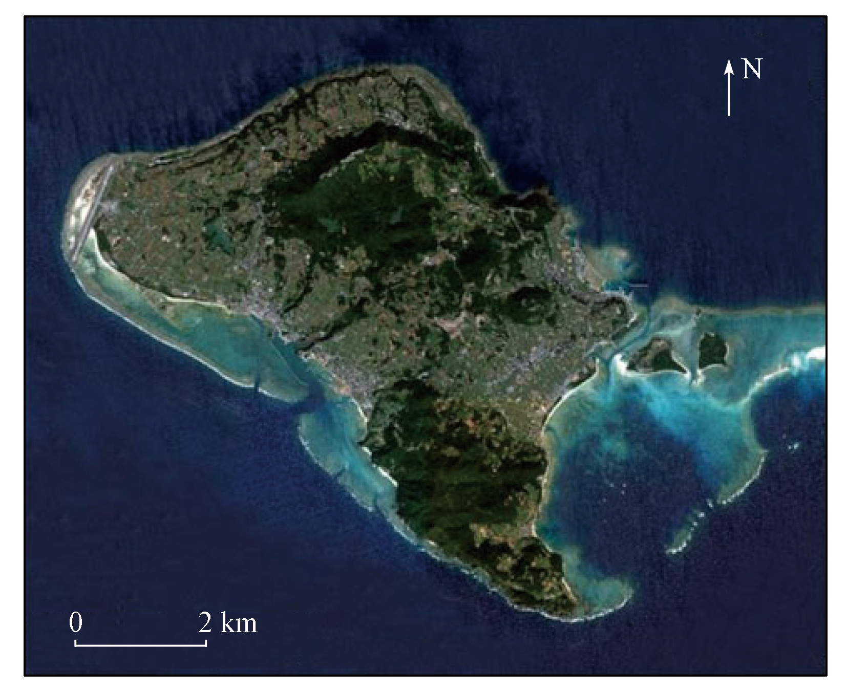
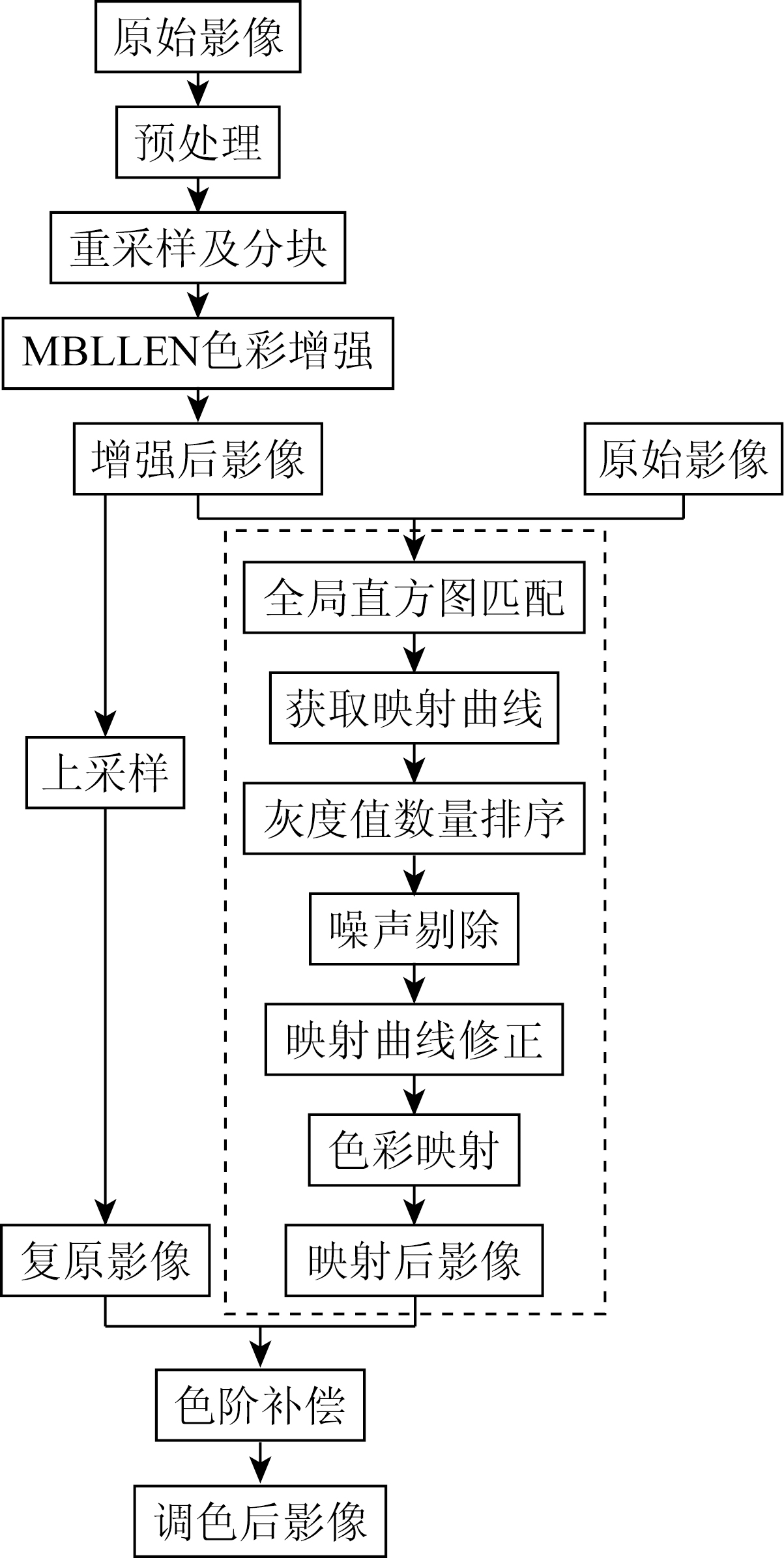
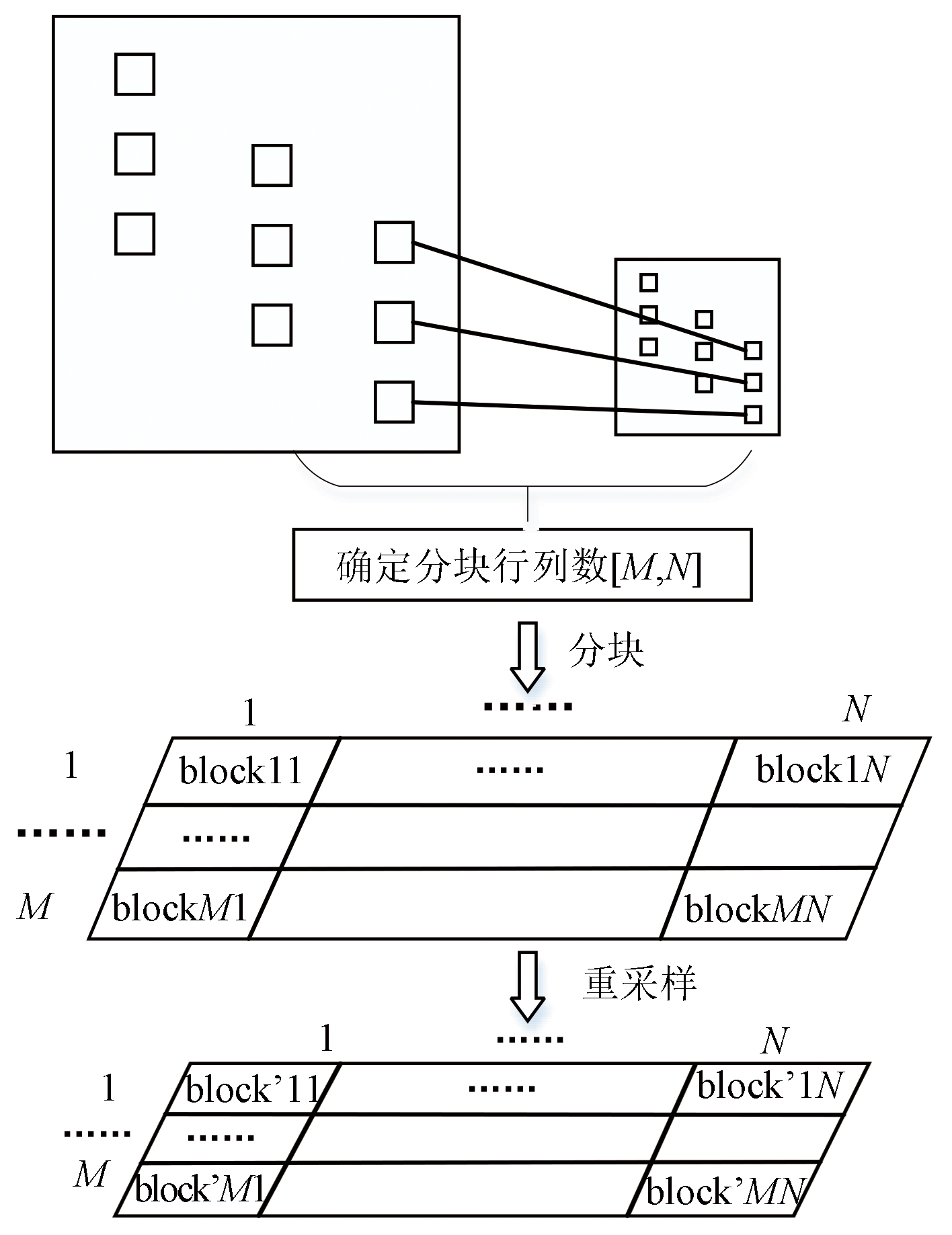
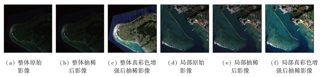
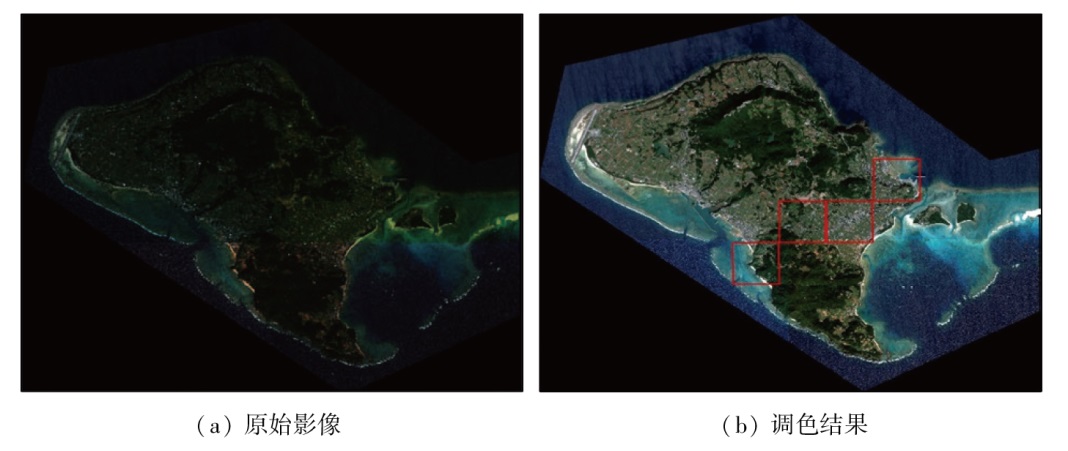
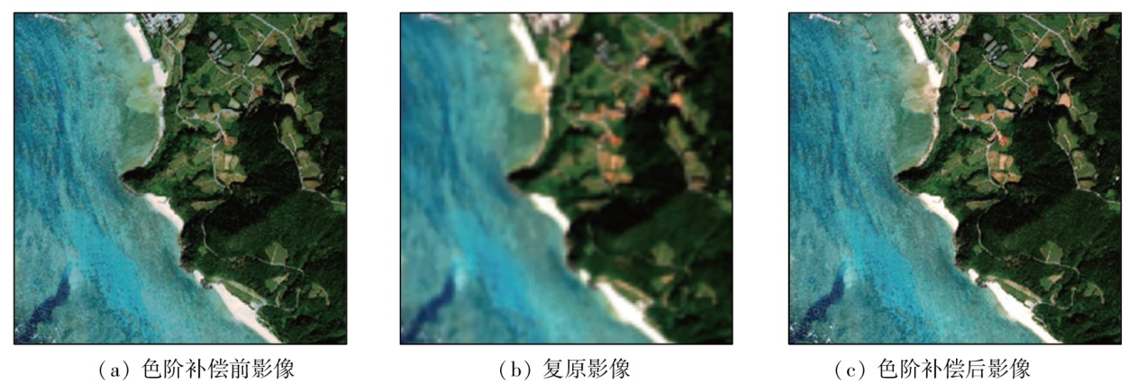
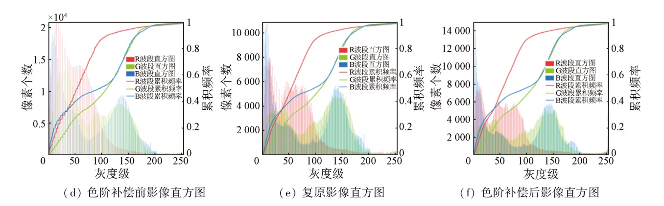
The original high-spatial-resolution remote sensing images of coastal zones of islands often exhibit a gray tone, color cast, and indistinguishable surface feature information. In response to the increasing demand for geographic information security of coastal zones of islands, this study aims to obtain timely clear remote sensing images with rich information, moderate contrast, and uniform brightness for island reefs. Hence, it proposed an intelligent color enhancement method by combining deep learning with improved histogram matching for high-spatial-resolution remote sensing images of coastal zones of islands. First, data resampling and adaptive chunking were performed to obtain thinned images. Then, the MBLLEN network was applied to enhance the thinned images with true color. Finally, an improved histogram matching method was employed for color mapping of original images, obtaining remote sensing images with consistent colors and rich details conforming to human vision. The color-matching effects of these obtained remote sensing images were evaluated using both subjective and objective methods. The results show that compared to other commonly used color-matching methods like Retinex, HE, and MASK, the method proposed in this study yielded more satisfactory results characterized by consistent colors and rich details conforming to human vision. Therefore, the proposed method can effectively improve the visual effects of high-spatial-resolution remote sensing images of coastal zones of islands, effectively retain the details of original surface features, and significantly enhance color-matching efficiency.
赵彬如, 牛思文, 王力彦, 杨晓彤, 焦红波, 王子珂. 面向海岛海岸带区域的高分遥感影像智能化色彩增强方法[J]. 自然资源遥感, 2024, 36(2): 70-79.
ZHAO Binru, NIU Siwen, WANG Liyan, YANG Xiaotong, JIAO Hongbo, WANG Zike. An intelligent color enhancement method for high-resolution remote sensing images of the coastal zone of an island. Remote Sensing for Natural Resources, 2024, 36(2): 70-79.
Li X M, Zhang J, Ma Y et al. Interpretation marks of SPOT-5 image on typical target types of islands and coastal zone in western Guangdong[J]. Marine Science Bulletin, 2011, 30(4):447-450,455.
[2]
余磊. 光学遥感卫星色彩一致性合成影像生成关键技术研究[D]. 武汉: 武汉大学, 2017.
Yu L. Key technology on color balancing for creation of color consistency synthetic products with optical remote sensing imagery[D]. Wuhan: Wuhan University, 2017.
Wu B, Jiang J B. Contrast enhancement algorithm of remote sensing images based on linking synaptic computation network[J]. Computer Applications and Software, 2020, 37(4):214-219.
Zhang X M, Sun W B, Yue G. True color restoration of multispectral image based on color constancy[J]. Journal of Ordnance Equipment Engineering, 2020, 41(11):248-256.
Zhang Q, Zhang Y M, Meng Y. Research on color uniforming for multi-source remote sensing images based on histogram matching method[J]. Geospatial Information, 2020, 18(12):54-57,7.
[8]
Rizzi A, Gatta C, Marini D. From Retinex to automatic color equalization:Issues in developing a new algorithm for unsupervised color equalization[J]. Journal of Electronic Imaging, 2004, 13(1):75-84.
Li D R, Wang M, Pan J. Auto-dodging processing and its application for optical RS images[J]. Geomatics and Information Science of Wuhan University, 2006, 31(9):753-756.
Wang M, Pan J. A method of removing the uneven illumination for digital aerial image[J]. Journal of Image and Graphics, 2004, 9(6):744-748.
[13]
Orsini G, Ramponi G, Carrai P, et al. A modified retinex for image contrast enhancement and dynamics control[C]// International Conference on Image Processing.IEEE, 2003:393-398.
[14]
Lam E Y. Combining gray world and retinex theory for automatic white balance in digital photography[C]// Proceedings of the Ninth International Symposium on Consumer Electronics,2005.(ISCE 2005).IEEE, 2005:134-139.
[15]
Seow M J, Asari V K. Ratio rule and homomorphic filter for enhancement of digital colour image[J]. Neurocomputing, 2006, 69(7/8/9):954-958.
[16]
Hsia S C, Chen M H, Chen Y M. A cost-effective line-based light-balancing technique using adaptive processing[J]. IEEE Transactions on Image Processing A Publication of the IEEE Signal Processing Society, 2006, 15(9):2719-2729.
[17]
李国. 基于遗传算法的遥感影像增强技术研究[D]. 郑州: 解放军信息工程大学, 2012.
Li G. The study of remote sensing image enhancement based on genetic algorithms[D]. Zhengzhou: Information Engineering University, 2012.
[18]
Li Q Q, Lu Y, Hu S B, et al. Review of remotely sensed geoenvironmental monitoring of coastal zones[J]. Journal of Remote Sensing, 2016, 20(5):1216-1229.
[19]
Lyu F F, Lu F, Wu J H, et al. MBLLEN:Low-light image/video enhancement using CNNs[C]// British MachineVision Conference.IEEE, 2018:.220-233.
Chen J L, Liu J L, Ye J H, et al. Luminance and chrominance correction for multi-view video using overlapped local histogram matching[J]. Journal of Image and Graphics, 2007, 12(11):1992-1999.
Zhou Y, Li Q W, Huo G Y. Adaptive image enhancement based on NSCT coefficient histogram matching[J]. Optics and Precision Engineering, 2014, 22(8):2214-2222.
 2024, Vol. 36
  ), 牛思文2, 王力彦1, 杨晓彤1, 焦红波1, 王子珂1(