Exploring the spatiotemporal differentiation and driving factors of vegetation dynamics in the Loess Plateau using the optimal parameter-based geographical detector model
SUN Yinsuo(), FANG Xiao, ZHOU Dongmao, XUE Hongwen, SU Junwu
The Third Geological Exploration Institute of China metallurgical Geology Bureau, Taiyuan 030002, China
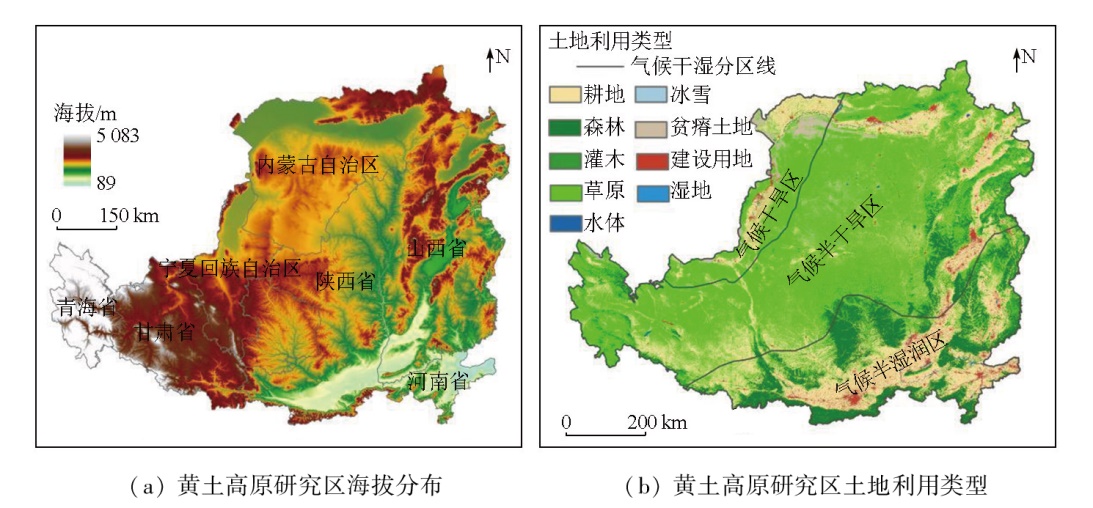
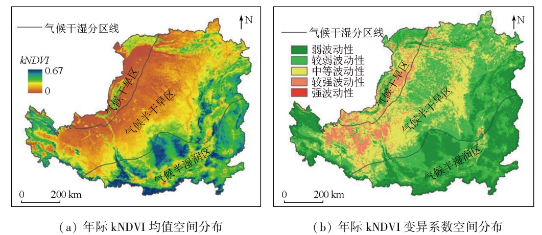
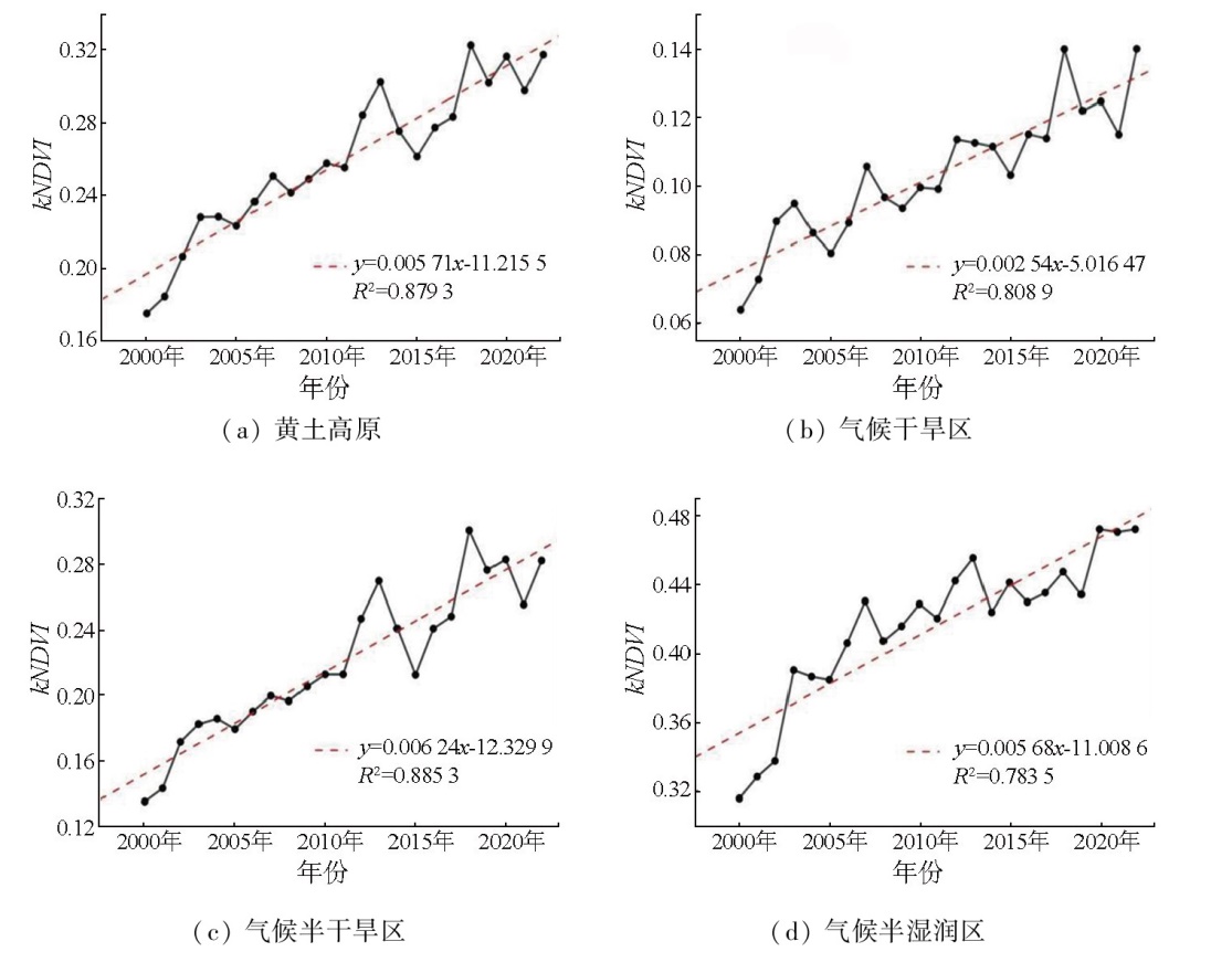
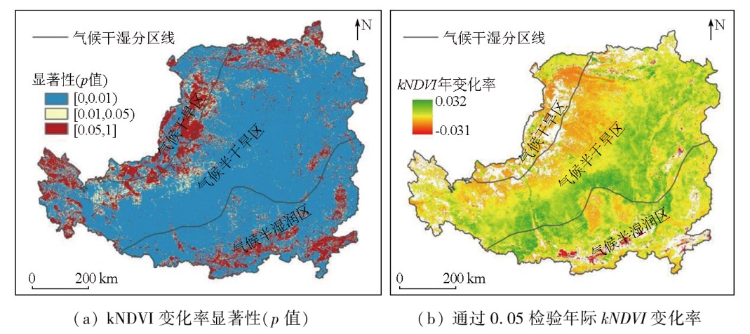
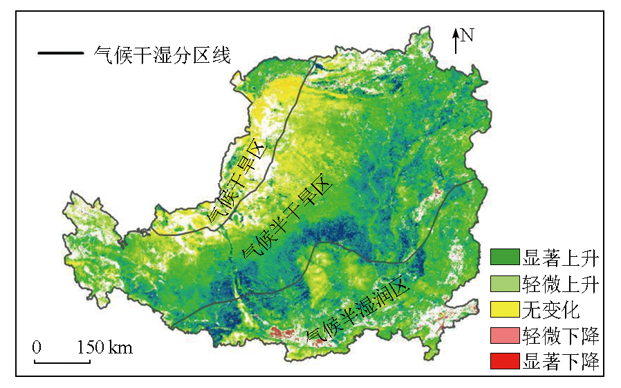
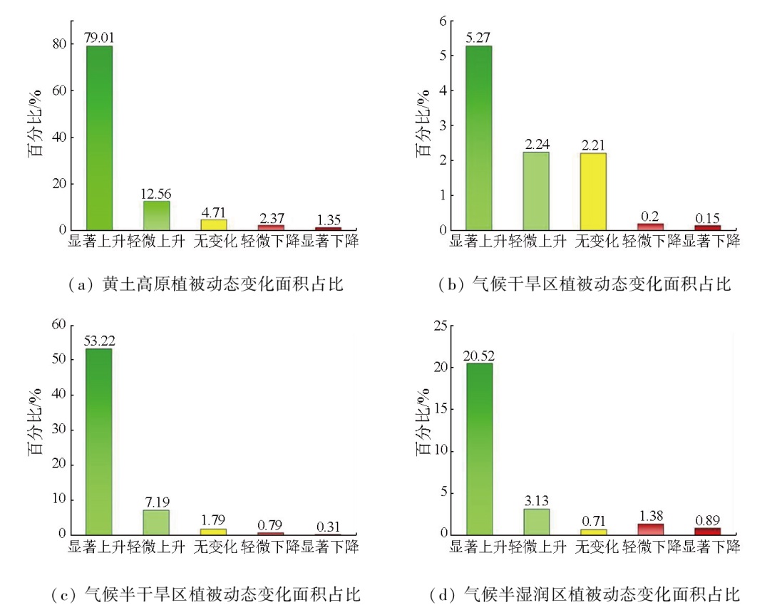
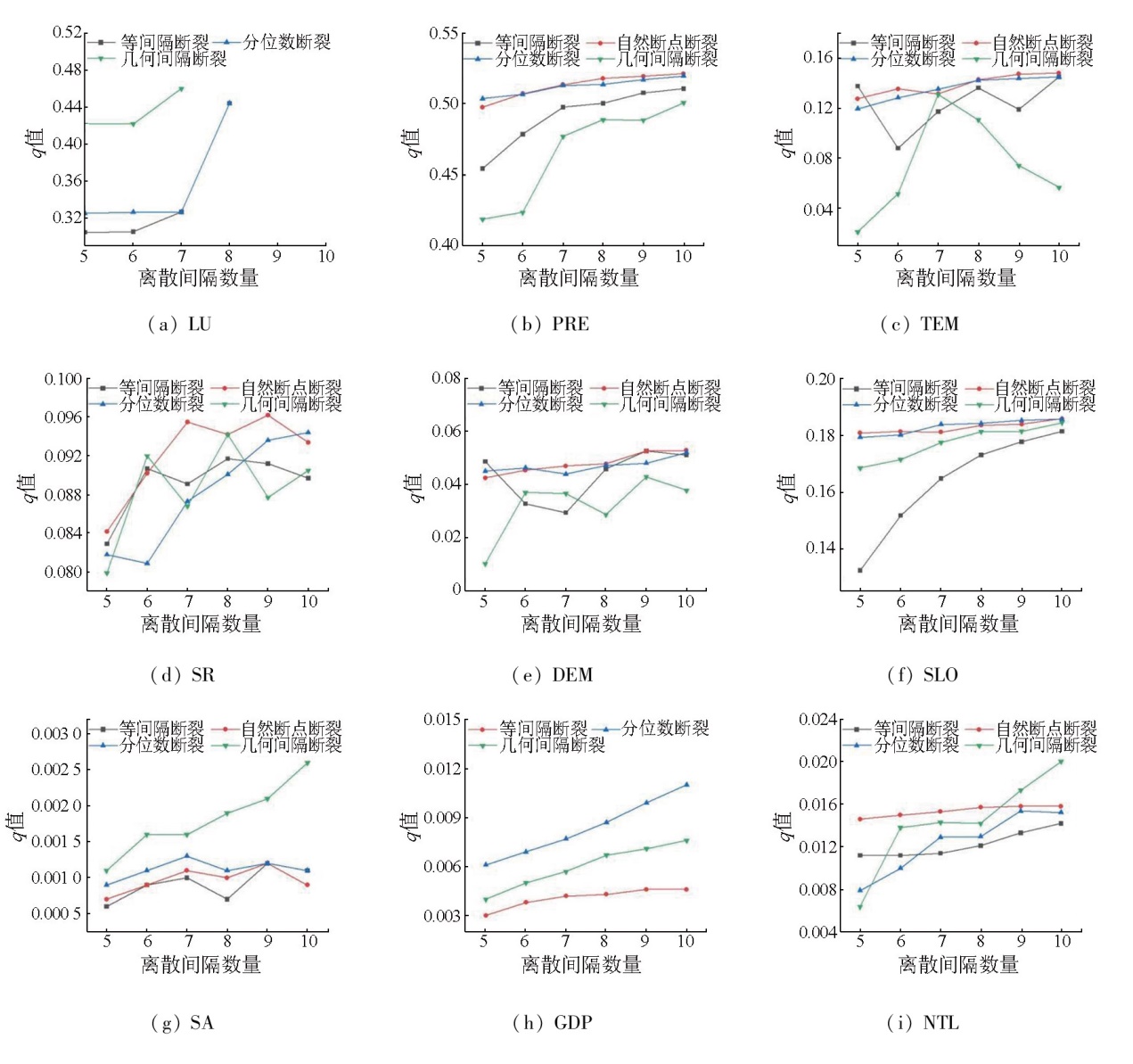
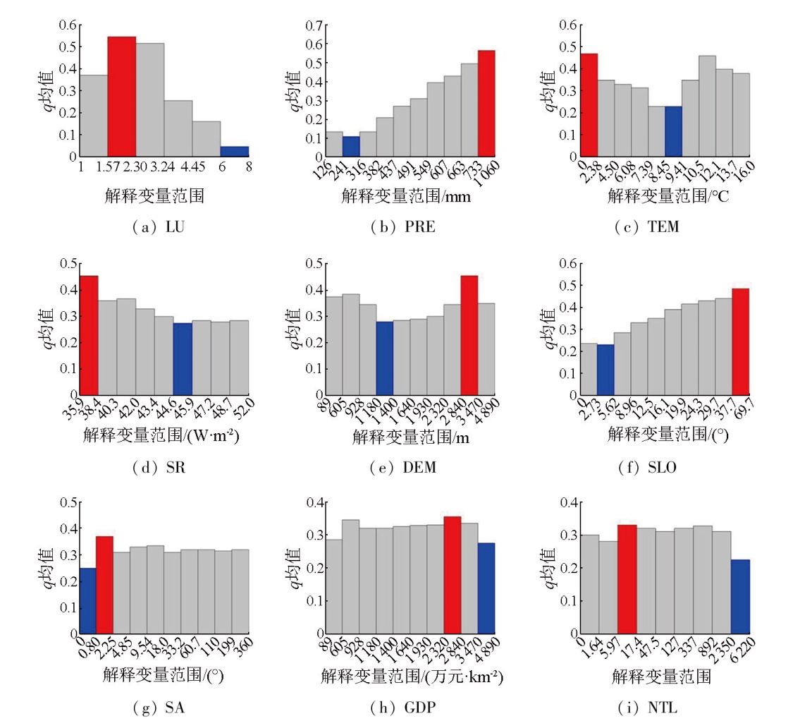
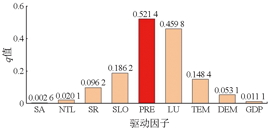
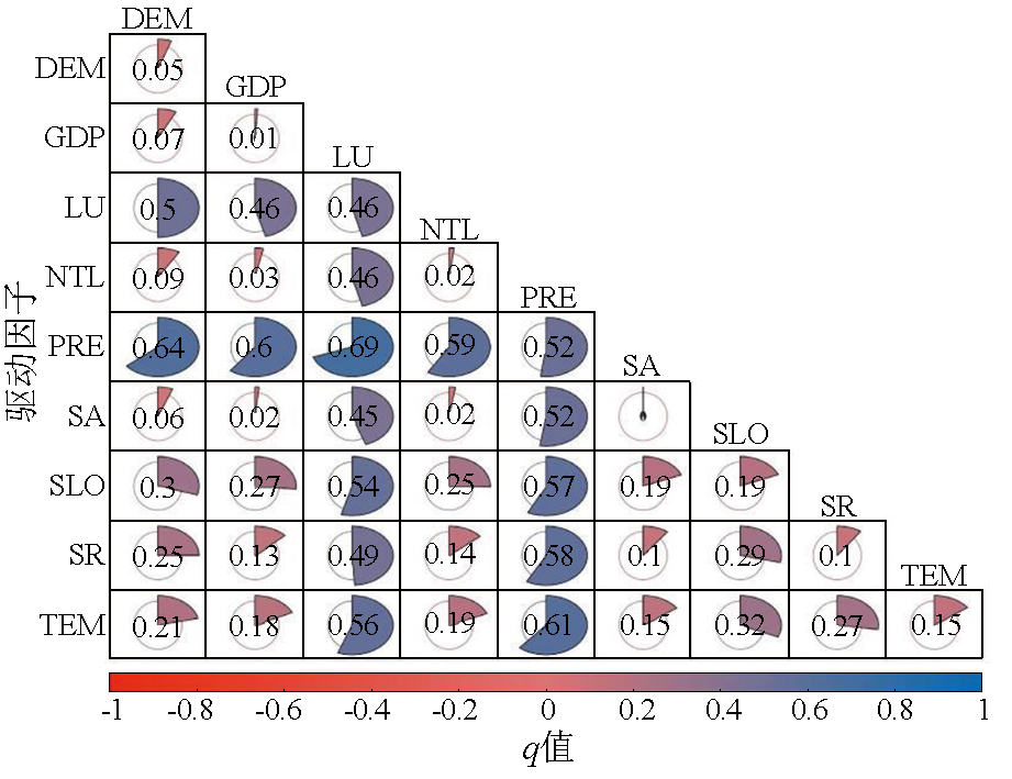
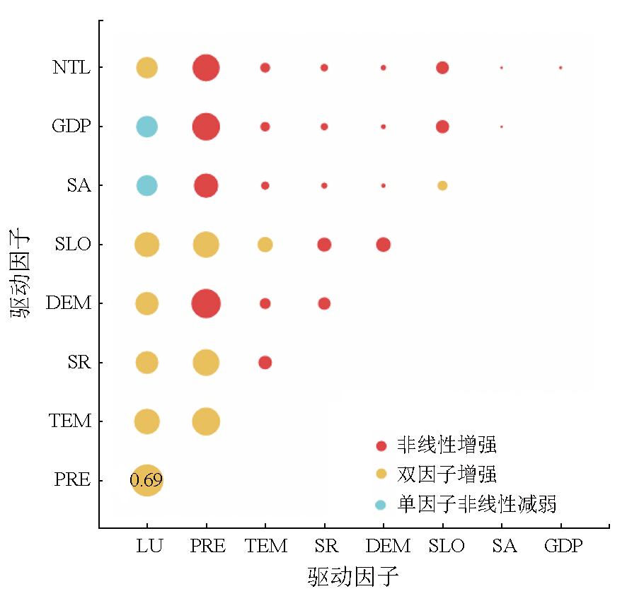
The Loess Plateau is recognized as a typical climate-sensitive and ecologically vulnerable region in China. Understanding the spatiotemporal characteristics and potential driving factors of vegetation dynamics in different dry/wet climate zones within the Loess Plateau holds critical significance for the conservation and management of regional ecosystems. Based on the kernel normalized difference vegetation indices (kNDVIs) of the Loess Plateau from 2000 to 2022, this study investigated the spatiotemporal patterns of vegetation dynamics in different dry/wet climate zones within the Loess Plateau using the coefficient of variation and trend analysis. Employing the optimal parameter-based geographical detector model, this study accurately and scientifically identified the driving factors and ranges of vegetation dynamics under the spatial scale and zoning effect, effectively addressing the challenge of spatial heterogeneity. The results indicate that the average kNDVI of the Loess Plateau presented a spatial distribution pattern characterized by low values in the northwest and high values in the southeast. In terms of vegetation dynamics, 91.57% of the Loess Plateau showed an upward trend, with the semi-arid climate zone accounting for the highest proportion (60.41%). Different driving factors in the Loess Plateau corresponded to varying optimal dispersion methods and optimal interval breakpoints. Under the optimal zoning effect, low temperature and high rainfall were identified as the primary conditions for vegetation growth. The different ranges and types of driving factors exerted different effects on the spatial distribution of vegetation dynamics. The optimal parameter-based geographical detector model demonstrates that rainfall and land use type constituted the principal driving factors of the Loess Plateau, accounting for 65.45% of the total explanatory power. The q value (0.69) of the interaction between the two driving factors was higher than the q values of interactions between other factors. This study provides a comprehensive insight into the response mechanisms of vegetation dynamics under natural and human factors, thereby guiding the sustainable development of regional ecosystems.
孙银锁, 方霄, 周东茂, 薛洪文, 苏俊武. 基于最优参数地理探测器模型的黄土高原植被动态时空序列分异及驱动力探究[J]. 自然资源遥感, 2025, 37(6): 169-181.
SUN Yinsuo, FANG Xiao, ZHOU Dongmao, XUE Hongwen, SU Junwu. Exploring the spatiotemporal differentiation and driving factors of vegetation dynamics in the Loess Plateau using the optimal parameter-based geographical detector model. Remote Sensing for Natural Resources, 2025, 37(6): 169-181.
Zhang R, Li Q, Yong X Y, et al. Quantitative reconstruction of pa-leovegetation history in Northeast China and its response to climate change since the Last Glacial Maximum[J]. Quaternary Sciences, 2024, 44(3):805-822.
[2]
Higgins S I, Conradi T, Muhoko E. Shifts in vegetation activity of terrestrial ecosystems attributable to climate trends[J]. Nature Geo-science, 2023, 16(2):147-153.
Dong W J, Mao X, Lu W J, et al. Long-term spatial heterogeneity of correlation between climatic factors and NDVI in the Yellow River Basin[J]. Science of Surveying and Mapping, 2024, 49(2):134-142.
[4]
Liu H Y, Zhang M Y, Lin Z S, et al. Spatial heterogeneity of the relationship between vegetation dynamics and climate change and their driving forces at multiple time scales in Southwest China[J]. Agricultural and Forest Meteorology, 2018,256:10-21.
Ye Z X, Zhang H B, Yang Z F, et al. Spatial differentiation effects and risk detection of meteorological elements to vegetation cover on the Loess Plateau of northern Shaanxi[J]. Acta Ecologica Sinica, 2024, 44(6):2379-2395.
Xie Z A, Zhang C, Feng S Y, et al. Reviews of methods for vegetation phenology monitoring from remote sensing data[J]. Remote Sensing Technology and Application, 2023, 38(1):1-14.
[7]
Li Y S, Ma J Y, Zhang Y J. Image retrieval from remote sensing big data:A survey[J]. Information Fusion, 2021,67:94-115.
Chen S X, Liu B J, Wang H Y, et al. Extraction of individual tree crown based on UAV tilt photogrammetry[J]. Remote Sensing Technology and Application, 2024, 39(1):34-44.
Zong H L, Zhang X L, Yuan X P, et al. Xiaojiang river basin ecological environmental quality spatiotemporal pattern and evolutio-nary trend analysis using GEE from 1990 to 2022[J]. Environmental Science, 2024, 45(7):4122-4136.
Liu Y, Zheng N S, Ding R, et al. NDVI inversion of multi-frequency and multi-satellite GNSS-IR model based on machine learning[J]. Journal of China University of Mining and Technology, 2023, 52(5):1014-1021.
[11]
Jin H Y, Chen X H, Wang Y M, et al. Spatio-temporal distribution of NDVI and its influencing factors in China[J]. Journal of Hydrology, 2021,603:127129.
[12]
Carlson T N, Ripley D A. On the relation between NDVI,fractional vegetation cover,and leaf area index[J]. Remote Sensing of Environment, 1997, 62(3):241-252.
doi: 10.1016/S0034-4257(97)00104-1
[13]
Aklilu T A, Gessesse A B. Evaluation of the saturation property of vegetation indices derived from sentinel-2 in mixed crop-forest ecosystem[J]. Spatial Information Research, 2021, 29(1):109-121.
doi: 10.1007/s41324-020-00339-5
[14]
Camps-Valls G, Campos-Taberner M, Moreno-Martínez Á, et al. A unified vegetation index for quantifying the terrestrial biosphere[J]. Science Advances, 2021, 7(9):eabc7447.
[15]
Wang X, Biederman J A, Knowles J F, et al. Satellite solar-induced chlorophyll fluorescence and near-infrared reflectance capture complementary aspects of dryland vegetation productivity dynamics[J]. Remote Sensing of Environment, 2022,270:112858.
Liu M R, Liu S T, Ma C Y, et al. Research progress of the responses of grassland plants and soilto the variation of temperature and precipitation[J]. Chinese Journal of Ecology, 2024, 43(12):3787-3796.
[17]
Yang S K, Liu J, Wang C H, et al. Vegetation dynamics influenced by climate change and human activities in the Hanjiang River Basin,Central China[J]. Ecological Indicators, 2022,145:109586.
Hu R, Dong L B. Temporal and spatial variations of vegetation co-verage in Heilongjiang Basin and its responses to climate change[J]. Chinese Journal of Applied Ecology, 2024, 35(6):1518-1524.
[19]
Li Q R, Gao X, Li J, et al. Nonlinear time effects of vegetation response to climate change:Evidence from Qilian Mountain National Park in China[J]. Science of the Total Environment, 2024,933:173149.
Niu J L, Chen G K, Huang Y Z, et al. Dynamic change of vegetation cover and its driving factors in Wenshan of Yunnan over the past 20 years[J]. Science of Soil and Water Conservation, 2022, 20(4):118-125.
Wang J F, Xu C D. Geodetector:Principle and prospective[J]. Acta Geographica Sinica, 2017, 72(1):116-134.
[22]
Zhao X Y, Tan S C, Li Y P, et al. Quantitative analysis of fractional vegetation cover in southern Sichuan urban agglomeration using optimal parameter geographic detector model,China[J]. Ecological Indicators, 2024,158:111529.
Wang Z F, Zheng B, He X Q, et al. Spatial-temporal variations and influencing factors of glacial lakes in Tibet based on Optimal Parameters-Based Geographical Detector[J]. Journal of Glaciology and Geocryology, 2023, 45(6):1950-1960.
Zheng J Y, Yin Y H, Li B Y. A new scheme for climate regionalization in China[J]. Acta Geographica Sinica, 2010, 65(1):3-12.
doi: 10.11821/xb201001002
[25]
Wang Q, Moreno-Martínez Á, Muñoz-Marínez J, et al. Estimation of vegetation traits with kernel NDVI[J]. ISPRS Journal of Photogrammetry and Remote Sensing, 2023,195:408-417.
Huang D, Peng A B, Liu J F, et al. Multi temporal and spatial scale responses of vegetation dynamics to climate factors[J]. Research of Soil and Water Conservation, 2023, 30(3):268-278.
[27]
Jiang W G, Yuan L H, Wang W J, et al. Spatio-temporal analysis of vegetation variation in the Yellow River Basin[J]. Ecological Indicators, 2015,51:117-126.
Yuan L H, Jiang W G, Shen W M, et al. The spatio-temporal variations of vegetation cover in the Yellow River Basin from 2000 to 2010[J]. Acta Ecologica Sinica, 2013, 33(24):7798-7806.
Shen A H, She J, Shi Y, et al. Changes in vegetation coverage of desert grasslands in the eastern foothills of Helan Mountains in 2001-2020[J]. Journal of Desert Research, 2024, 44(3):308-320.
doi: 10.7522/j.issn.1000-694X.2024.00035
[30]
Song Y Z, Wang J F, Ge Y, et al. An optimal parameters-based geo-graphical detector model enhances geographic characteristics of explanatory variables for spatial heterogeneity analysis:Cases with different types of spatial data[J]. GIScience and Remote Sensing, 2020, 57(5):593-610.
doi: 10.1080/15481603.2020.1760434
[31]
Wang J F, Hu Y. Environmental health risk detection with GeogDetector[J]. Environmental Modelling and Software, 2012,33:114-115.
[32]
Zhang W, Wang L C, Xiang F F, et al. Vegetation dynamics and the relations with climate change at multiple time scales in the Yangtze River and Yellow River Basin,China[J]. Ecological Indicators, 2020,110:105892.
Ma F L, Liu X W, Duo Y, et al. Effects of daily variation of hydro-thermal factors on alpine grassland productivity on the Qinghai-Tibet Plateau[J]. Acta Ecologica Sinica, 2023, 43(9):3719-3728.
Han L, Cao X X, Zhu H L, et al. Change of vegetation coverage and driving factor in the North Shaanxi Loess Plateau based on characteristic zoning[J]. Acta Ecologica Sinica, 2023, 43(20):8564-8577.
He J Q, Wei Y, Gao W D, et al. Temporal and spatial variation of vegetation NDVI and its response to climatic factors in the sout-heastern margin of Mu Us Sandy Land[J]. Arid Land Geography, 2022, 45(5):1523-1533.
Wang X, Zhang C, Li Q. Path analysis between vegetation coverage and climate factors in the Loess Plateau[J]. Acta Ecologica Sinica, 2023, 43(2):719-730.
[37]
Jiao W, Wang L, Smith W K, et al. Observed increasing water constraint on vegetation growth over the last three decades[J]. Nature Communications, 2021, 12(1):3777.
doi: 10.1038/s41467-021-24016-9
pmid: 34145253
Li Z Y, Yang Q, Ma Z G, et al. Responses of vegetation to climate change and human activities in the arid and semiarid regions of northern China[J]. Chinese Journal of Atmospheric Sciences, 2024, 48(3):859-874.
Yao N, Dong G T, Xue H Z. Analysis on the characteristics of the spatiotemporal change in vegetation coverage on the Loess Plateau using the Google Earth Engine[J]. Research of Soil and Water Conservation, 2024, 31(1):260-268.
Tu N R, Hong M, Ye H, et al. Effects of precipitation change and nitrogen deposition on soil arbuscular mycorrhizal fungi(AMF) community structure in desert steppe[J]. Soils, 2023, 55(6):1251-1260.
[41]
Ren H Y, Wen Z M, Liu Y Y, et al. Vegetation response to changes in climate across different climate zones in China[J]. Ecological Indicators, 2023,155:110932.
 2025, Vol. 37
  ), 方霄, 周东茂, 薛洪文, 苏俊武