|
|
|
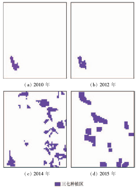
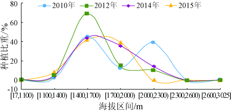
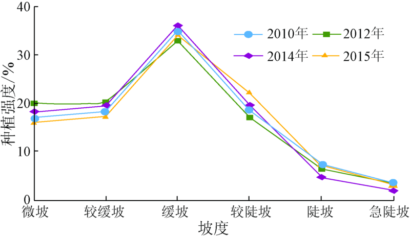
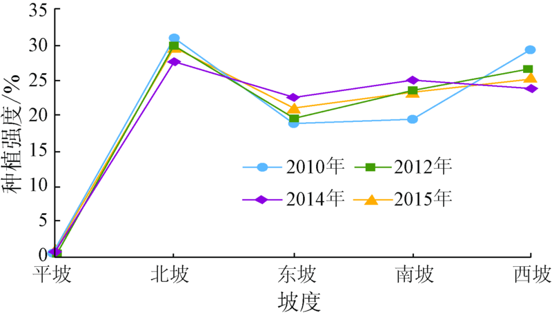
Abstract Monitoring the planting area and growth status of rare medical herbs is a new direction of remote sensing application. Pseudo-ginseng, as a commercial and severe planted crop in Yunnan Province, has a significant influence on the regional land use and financial income. Thus, the accurate monitoring of the planting area and the trend of pseudo-ginseng is of vital importance. Based on the analysis of spectral and spatial features of the pseudo-ginseng plantation, an efficient method to extract the planting areas of pseudo-ginseng was proposed and its change was analyzed using multi-temporal remote sensing images. Experimental results demonstrated that the planting area of pseudo-ginseng in Wenshan and Honghe has kept grown from 2010 to 2015, especially from 2012 to 2014 with a rapid speed. However, the market price decreased because supply exceeds demand in this period. Compared to the market price, the planting area has a obvious lag effect. Furthermore, the pseudo-ginseng plantation is concentrated in the appropriate elevation gradients between 1400 and 2000 m, with the slope below 25°.
|
| Keywords
pseudo-ginseng
topographical factors
spatial-temporal variation
hysteresis quality
|
|
|
|
Issue Date: 08 February 2018
|
|
|
| [1] |
崔秀明,黄璐琦,郭兰萍,等.中国三七产业现状及发展对策[J].中国中药杂志,2014,39(4):553-557.
|
| [1] |
Cui X M,Huang L Q,Guo L P,et al.Chinese Sanqi industry status and development countermeasures[J].China Journal of Chinese Materia Medica,2014,39(4):553-557.
|
| [2] |
黄天卫. 浅谈文山三七产业发展的现状及对策[J].云南科技管理,2003,16(5):60-63.
|
| [2] |
Huang T W.Introduction to Wenshan Sanqi industry status and development countermeasures[J].Yunnan Science and Technology Management,2003,16(5):60-63.
|
| [3] |
杨文彩,朱有勇,张汝坤,等.基于可持续发展的三七产业农机农艺融合工程技术体系研究[J].湖北农业科学,2014,53(1):122-125,129.
|
| [3] |
Yang W C,Zhu Y Y,Zhang R K,et al.Studies on the engineering and technical system of integrating agricultural machinery and agronomic based on sustainable development of Panax notoginseng industry[J].Hubei Agricultural Science,2014,53(1):122-125,129.
|
| [4] |
郑冬梅,王丽,欧小宏,等.三七传统产区和新产区植株农艺性状比较及相互关系研究[J].中国中药杂志,2014,39(4):558-565.
|
| [4] |
Zheng D M,Wang L,Ou X H,et al.Comparison of agronomic traits of Panax notoginseng between traditional cultivated fields and new cultivated fields[J].China Journal of Chinese Materia Medica,2014,39(4):558-565.
|
| [5] |
张子龙,王文全,缪作清,等.主成分分析在三七连作土壤质量综合评价中的应用[J].生态学杂志,2013,32(6):1636-1644.
|
| [5] |
Zhang Z L,Wang W Q,Miu Z Q,et al Z.Application of principal component analysis in comprehensive assessment of soil quality under Panax notoginseng continuous planting[J].Chinese Journal of Ecology,2013,32(6):1636-1644.
|
| [6] |
马明国,王建,王雪梅.基于遥感的植被年际变化及其与气候关系研究进展[J].遥感学报,2006,10(3):421-431.
|
| [6] |
Ma M G,Wang J,Wang X M.Advance in the inter-annual variability of vegetation and its relation to climate based on remote sensing[J].Journal of Remote Sensing,2006,10(3):421-431.
|
| [7] |
张小波,孙宇章,黄璐琦,等.野生稀有种药用植物遥感监测方法及其标准的建立[J].中国中药杂志,2009,34(13):1741-1744.
|
| [7] |
Zhang X B,Sun Y Z,Huang L Q,et al.Establish remote of sensing monitoring method and standard on wild rare medical plant[J].China Journal of Chinese Materia Medica,2009,34(13):1741-1744.
|
| [8] |
周长吉.变迁中的“三七”种植设施[J].农业工程技术(温室园艺),2015(19):20,22,24,26.
|
| [8] |
Zhou C J.The Changes of Sanqi planting facilities[J].Agricultural Engineering Technology(Greenhouse Horticulture),2015(19):20,22,24,26.
|
| [9] |
李运刚,何大明,叶长青.云南红河流域径流的时空分布变化规律[J].地理学报,2008,63(1):41-49.
|
| [9] |
Li Y G,He D M,Ye C Q.The variation of runoff of red river Basin in Yunnan[J].Acta Geographica Sinica,2008,63(1):41-49.
|
| [10] |
周清华. 云南省文山州三七产业化发展研究[D].昆明:云南大学,2014.
|
| [10] |
Zhou Q H.Research on Panax Industrial Development Strategy of Wenshan Yunnan Province[D].Kunming:Yunnan University,2014.
|
| [11] |
刘英,曲媛,崔秀明,等.文山、红河三七花皂苷含量的比较研究[J].云南大学学报:自然科学版,2014,36(5):734-739.
|
| [11] |
Liu Y,Qu Y,Cui X M,et al.Content comparison of ginsenosides from the flowers of Panax notoginseng in Wenshan prefecture and Honghe prefecture[J].Journal of Yunnan University,2014,36(5):734-739.
|
| [12] |
蒲莉莉,刘斌.结合光谱响应函数的Landsat-8影像大气校正研究[J].遥感信息,2015,30(2):116-119.
|
| [12] |
Pu L L,Liu B.Atmospheric correction of Landsat-8 imagery based on spectral response function[J].Remote Sensing Information,2015,30(2):116-119.
|
| [13] |
中华人民共和国水利部.SL 190—1996土壤侵蚀分类分级标准[S].北京:中国水利水电出版社,1997.
|
| [13] |
The Ministry of Water Resource of the People’s Republic of China.SL 190—1996 Standards for Classification and Gradation of Soil Erosion[S].Beijing:China Water & Power Press,1997.
|
| [14] |
封志明,刘晓娜,姜鲁光,等.中老缅交界地区橡胶种植的时空格局及其地形因素分析[J].地理学报,2013,68(10):1432-1446.
|
| [14] |
Feng Z M,Liu X N,Jiang L G,et al.Spatial-temporal analysis of rubber plantation and its Relationship with topographical factors in the border region of China,Laos and Myanmar[J].Acta Geographica Sinica,2013,68(10):1432-1446.
|
| [15] |
刘晓行,李宏.云南文山三七市场价格变动分析和产业可持续发展研究[J]. 农村经济与科技, 2015(9):145-147,233.
|
| [15] |
Liu X X,Li H.Research on the market price movments and sustainable development of pseudo-ginseng in Wenshan Yunnan Province[J]. Rural Economy and Science, 2015(9):145-147,233.
|
|
Viewed |
|
|
|
Full text
|
|
|
|
|
Abstract
|
|
|
|
|
Cited |
|
|
|
|
| |
Shared |
|
|
|
|
| |
Discussed |
|
|
|
|
 2018,
Vol. 30
2018,
Vol. 30
 ), Xiangjian XIE, Zhigang XU, Peijun DU(