|
|
|
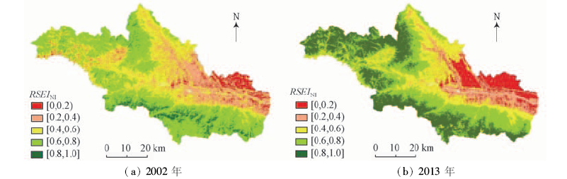
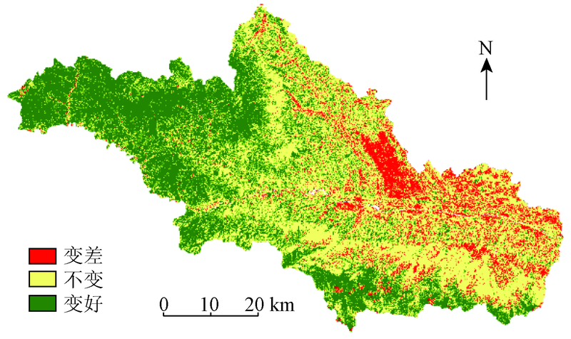
Abstract Using remote sensing method to study eco-environment quality changes is immediate and rapid. Based on remote sensing image and principle component analysis, the authors combined vegetation index, wet index, dryness index and temperature index to evaluate the eco-environment quality of Baoji City and the land-use types from 2002 to 2013. The results indicate that the ecological construction work has made remarkable achievements in the past 10 years. The area of improved eco-environment quality reached 39.50%, while the area of degraded quality possessed only 10.96%; in addition, synthetical ecological index (ESI) increased from 3.25 to 3.56. The eco-environment quality of Chencang District and Weibin District was improved while that of Jintai District was degraded. The ESI of land-use types from high to low is forest land, unexploited land, grassland, waters, cultivated land and construction land. RSEI degree of cultivated land has no significant change, that of forest land, grassland and unexploited land have been improved while water and construction land have been degraded.
|
| Keywords
remote sensing
principal component analysis
eco-environment
land-use type
RSEI
|
|
|
|
Issue Date: 08 February 2018
|
|
|
| [1] |
李佩成. 再造西北地区是山川秀美是可实现的千秋伟业[J].地球科学与环境学报,2011,33(1):10-13.
|
| [1] |
Li P C.To rebuild a grand northwest China with beautiful landscape is accomplishable great career[J].Journal of Earth Sciences and Environment,2011,33(1):10-13.
|
| [2] |
秦大河,丁一汇,王绍武,等.中国西部生态环境变化与对策建议[J].地球科学进展,2002,17(3):314-319.
|
| [2] |
Qin D H,Ding Y H,Wang S W,et al.Ecological and environmental change in west China and its response strategy[J].Advance in Earth Sciences,2002,17(3):314-319.
|
| [3] |
Pauleit S,Duhme F.Assessing the environmental performance of land cover types for urban planning[J].Landscape and Urban Planning,2000,52(1):1-20.
|
| [4] |
叶亚平,刘鲁君.中国省域生态环境质量评价指标体系研究[J].环境科学研究,2000,13(3):33-36.
|
| [4] |
Ye Y P,Liu L J.A preliminary study on assessment indicator system of provincial eco-environmental quality in China[J].Research of Environmental Sciences,2000,13(3):33-36.
|
| [5] |
付哲,周云轩,刘殿伟,等.生态环境质量的空间模糊综合评价研究:以吉林省西部为例[J].干旱区资源与环境,2005,19(5):97-102.
|
| [5] |
Fu Z,Zhou Y X,Liu D W,et al.Research on spatial fuzzy comprehensive assessment of eco-environmental quality:A case study in the west of Jilin Province[J].Journal of Arid Land Resources and Environment,2005,19(5):97-102.
|
| [6] |
李恺. 层次分析法在生态环境综合评价中的应用[J].环境科学与技术,2009,32(2):183-185.
|
| [6] |
Li K.Application of analytical hierarchy process to integrate evaluation of eco-environment[J].Environmental Science and Technology,2009,32(2):183-185.
|
| [7] |
高志强,刘纪远,庄大方.基于遥感和GIS的中国土地资源生态环境质量同人口分布的关系研究[J].遥感学报,1999,3(1):66-70.
|
| [7] |
Gao Z Q,Liu J Y,Zhuang D F.The relations analysis between ecological environmental quality of Chinese land resources and population[J].Journal of Remote Sensing,1999,3(1):66-70.
|
| [8] |
中华人民共和国环境保护部.HJ 192—2015生态环境状况评价技术规范[S].北京:中国环境科学出版社,2015.
|
| [8] |
Ministry of Environmental Protection of the People’s Republic of China.HJ 192—2015 Technical Criterion for Ecosystem Status Evaluation[S].Beijing:China Environmental Science Press,2015.
|
| [9] |
王南. 基于退耕还林还草背景的通辽市生态环境状况综合评价[D].大连:辽宁师范大学,2012:1-28.
|
| [9] |
Wang N.Evaluation on Eco-environmental Quality of Tongliao Based on Conversion of Cultivated Land to Woodland and Grassland[D].Dalian:Liaoning Normal University,2012:1-28.
|
| [10] |
李莉,张华.基于退耕还林还草背景的奈曼旗生态环境质量评价[J]. 国土与自然资源研究, 2010(1):48-49.
|
| [10] |
Li L,Zhang H.The evaluation on eco-environmental quality based on brain for breen in Naiman Qi[J]. Territory and Natural Resources Study, 2010(1):48-49.
|
| [11] |
李妮娅,唐瑶,杨丽,等.基于遥感技术的白水河流域生态环境质量现状研究[J].华中师范大学学报(自然科学版),2013,47(1):103-107.
|
| [11] |
Li N Y,Tang Y,Yang L,et al.Ecological environment quality of Baishui River basin based on remote sensing technology[J].Journal of Huazhong Normal University(Natural Sciences),2013,47(1):103-107.
|
| [12] |
万红梅,李霞,董道瑞.基于多源遥感数据的荒漠植被覆盖度估测[J].应用生态学报,2012,23(12):3331-3337.
|
| [12] |
Wan H M,Li X,Dong D R.Estimation of desert vegetation coverage based on multi-source remote sensing data[J].Chinese Journal of Applied Ecology,2012,23(12):3331-3337.
|
| [13] |
徐涵秋. 城市遥感生态指数的创建及其应用[J].生态学报,2013,33(24):7853-7862.
|
| [13] |
Xu H Q.A remote sensing urban ecological index and its application[J].Acta Ecologica Sinica,2013,33(24):7853-7862.
|
| [14] |
徐涵秋. 区域生态环境变化的遥感评价指数[J].中国环境科学,2013,33(5):889-897.
|
| [14] |
Xu H Q.A remote sensing index for assessment of regional ecological changes[J].China Environmental Science,2013,33(5):889-897.
|
| [15] |
李粉玲,常庆瑞,申健,等.黄土高原沟壑区生态环境状况遥感动态监测——以陕西省富县为例[J].应用生态学报,2015,26(12):3811-3817.
|
| [15] |
Li F L,Chang Q R,Shen J,et al.Dynamic monitoring of ecological environment in Loess hilly and gully region of Loess Plateau based on remote sensing:A case study on Fuxian County in Shaanxi Province,Northwest China[J].Chinese Journal of Applied Ecology,2015,26(12):3811-3817.
|
| [16] |
刘智才,徐涵秋,李乐,等.基于遥感生态指数的杭州市城市生态变化[J].应用基础与工程科学学报,2015,23(4):728-739.
|
| [16] |
Liu Z C,Xu H Q,Li L,et al.Ecological change in the Hangzhou area using the remote sensing based ecological index[J].Journal of Basic Science and Engineering,2015,23(4):728-739.
|
| [17] |
白建军,白江涛,王磊.2000—2010年陕北地区植被NDVI时空变化及其与区域气候的关系[J].地理科学,2014,34(7):882-888.
|
| [17] |
Bai J J,Bai J T,Wang L.Spatio-temporal change of vegetation NDVI and its relations with regional climate in Northern Shaanxi Province in 2000—2010[J].Scientia Geographica Sinica,2014,34(7):882-888.
|
| [18] |
张景华,封志明,姜鲁光,等.澜沧江流域植被NDVI与气候因子的相关性分析[J].自然资源学报,2015,30(9):1425-1435.
|
| [18] |
Zhang J H,Feng Z M,Jiang L G,et al.Analysis of the correlation between NDVI and climate factors in the Lancang River basin[J].Journal of Natural Resources,2015,30(9):1425-1435.
|
| [19] |
吴志杰,赵书河.基于TM图像的“增强的指数型建筑用地指数”研究[J].国土资源遥感,2012,24(2):50-55.doi:10.6046/gtzyyg.2012.02.10.
|
| [19] |
Wu Z J,Zhao S H.A study of enhanced index-based built-up index based on Landsat TM imagery[J].Remote Sensing for Land and Resources,2012,24(2):50-55.doi:10.6046/gtzyyg.2012.02.10.
|
| [20] |
白洁,刘邵民,扈光.针对TM/ETM+遥感数据的地表温度反演与验证[J].农业工程学报,2008,24(9):148-154.
|
| [20] |
Bai J,Liu S M,Hu G.Inversion and verification of land surface temperature with remote sensing TM/ETM+ data[J].Transactions of the Chinese Society of Agricultural Engineering,2008,24(9):148-154.
|
| [21] |
覃志豪,Zhang M H,Karnieli A,等.用陆地卫星TM6数据演算地表温度的单窗算法[J].地理学报,2001,56(4):456-466.
|
| [21] |
Qin Z H,Zhang M H,Karnieli A,et al.Mono-window algorithm for retrieving land surface temperature from Landsat TM6 data[J].Acta Geographica Sinica,2001,56(4):456-466.
|
| [22] |
宋挺,段峥,刘军志,等.Landsat 8数据地表温度反演算法对比[J].遥感学报,2015,19(3):451-464.
|
| [22] |
Song T,Duan Z,Liu J Z,et al.Comparison of four algorithms to retrieve land surface temperature using Landsat 8 satellite[J].Journal of Remote Sensing,2015,19(3):451-464.
|
| [23] |
Anyamba A,Small J L,Tucker C J,et al.Thirty-two years of Sahelian zone growing season non-stationary NDVI3g patterns and trends[J].Remote Sensing,2014,6(4):3101-3122.
|
| [24] |
Carlson T N,Arthur S T.The impact of land use-land cover changes due to urbanization on surface microclimate and hydrology:A satellite perspective[J].Global and Planetary Change,2000,25(1/2):49-65.
|
| [25] |
林海明,杜子芳.主成分分析综合评价应该注意的问题[J].统计研究,2013,30(8):25-31.
|
| [25] |
Lin H M,Du Z F.Some problems in comprehensive evaluation in the principal component analysis[J].Statistical Research,2013,30(8):25-31.
|
| [26] |
雷超桂,许有鹏,张倩玉,等.流域土地利用变化对不同重现期洪水的影响——以奉化江皎口水库流域为例[J].生态学报,2016,36(16):5017-5026.
|
| [26] |
Lei C G,Xu Y P,Zhang Q Y,et al.Impacts of land-use change on flood process and frequency of various return periods:A case study of Jiaokou reservoir watershed in Fenghua River[J].Acta Ecologica Sinica,2016,36(16):5017-5026.
|
| [27] |
崔天翔,宫兆宁,赵文吉,等.不同端元模型下湿地植被覆盖度的提取方法——以北京市野鸭湖湿地自然保护区为例[J].生态学报,2013,33(4):1160-1171.
|
| [27] |
Cui T X,Gong Z N,Zhao W J,et al.Research on estimating wetland vegetation abundance based on spectral mixture analysis with different endmember model:A case study in wild duck lake wetland,Beijing[J].Acta Ecologica Sinica,2013,33(4):1160-1171.
|
| [28] |
李建芳. 近80年宝鸡市旱涝变化特征分析[J].干旱区资源与环境,2012,26(10):13-17.
|
| [28] |
Li J F.Characteristics of drought and flood changes in Baoji[J].Journal of Arid Land Resources and Environment,2012,26(10):13-17.
|
|
Viewed |
|
|
|
Full text
|
|
|
|
|
Abstract
|
|
|
|
|
Cited |
|
|
|
|
| |
Shared |
|
|
|
|
| |
Discussed |
|
|
|
|
 2018,
Vol. 30
2018,
Vol. 30
 ), Yanfang ZHANG(