|
|
|
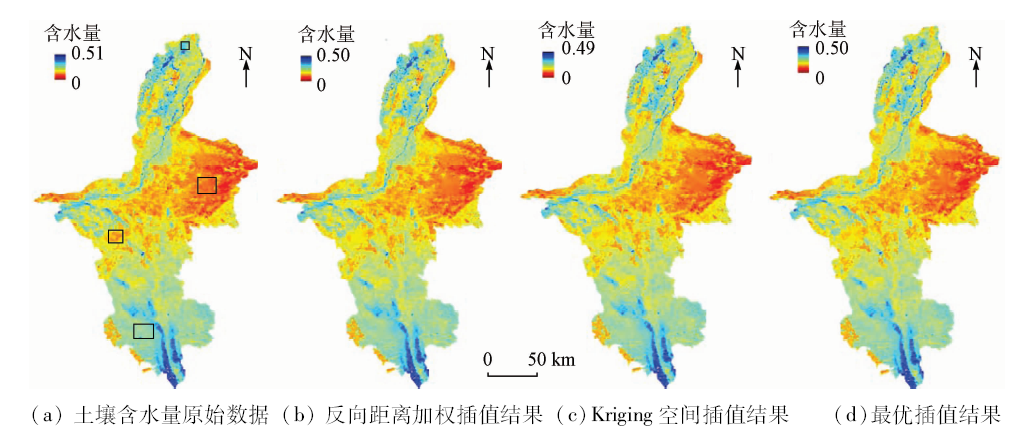
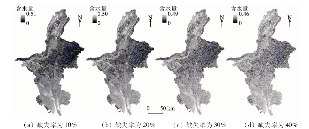
Abstract Remote sensing-based soil moisture content inversion is an indispensable procedure in drought monitoring; however, the image acquisition process is often influenced by bad weather such as cloud cover and snowfall, or sensor performance defects, which causes missing data. The existing filtering interpolation methods based on time series images have a high requirement on input data and thus are difficult to be widely applied, while the spatial interpolation methods do not work well for the images with missing blocks. In view of the above problems, this paper proposes a missing data filling method based on optimum interpolation, which predicts and fills missing data with the ground observation data as a reference. The authors selected Ningxia as the study area and obtained the soil moisture content in multiple periods using the VCADI index, and conducted missing pixel interpolation using the proposed method with the ground observation data of 16 national meterological stations. Experimental results show that the proposed method performs well in all regions with different levels of missing data. The authors simulated the images with missing blocks and different levels of missing data, and compared the performances between the inverse distance weighted interpolation method, the Kriging interpolation method and the optimum interpolation method. Experimental results show that the method proposed by the authors can obtain more accurate interpolation results.
|
| Keywords
soil moisture content
remote sensing inversion
optimum interpolation
missing data
|
|
|
|
Corresponding Authors:
Heng DONG
E-mail: junli_geo@126.com;simondong@whut.edu.cn
|
|
Issue Date: 30 May 2018
|
|
|
| [1] |
Wilhite D A, Buchanan-Smith M . Drought as Hazard:Understanding the Natural and Social Context[M] //Wilhite D A.Drought and Water Crises Science,Technology,and Management Issues.Boca Raton:Taylor and Francis Group, 2005.
|
| [2] |
翁白莎, 严登华 . 变化环境下中国干旱综合应对措施探讨[J]. 资源科学, 2010,32(2):309-316.
url: 年度引用
|
| [2] |
Weng B S, Yan D H . Integrated strategies for dealing with droughts in changing environment in China[J]. Resources Science, 2010,32(2):309-316.
|
| [3] |
周磊, 武建军, 张洁 . 以遥感为基础的干旱监测方法研究进展[J]. 地理科学, 2015,35(5):630-636.
url: http://www.cqvip.com/QK/95809X/201505/68767588504849534853484954.html
|
| [3] |
Zhou L, Wu J J, Zhang J . Remote sensing-based drought monitoring approach and research progress[J]. Scientia Geographica Sinica, 2015,35(5):630-636.
|
| [4] |
杨绍锷, 闫娜娜, 吴炳方 . 农业干旱遥感监测研究进展[J].遥感信息, 2010(1):103-109.
|
| [4] |
Yang S E, Yan N N, Wu B F . Advances in agricultural drought monitoring by remote sensing[J].Remote Sensing Information, 2010(1):103-109.
|
| [5] |
吴代晖, 范闻捷, 崔要奎 , 等. 高光谱遥感监测土壤含水量研究进展[J]. 光谱学与光谱分析, 2010,30(11):3067-3071.
url: http://www.opticsjournal.net/Articles/Abstract?aid=OJ110126000696GdJfMi
|
| [5] |
Wu D H, Fan W J, Cui Y K , et al. Review of monitoring soil water content using hyperspectral remote sensing[J]. Spectroscopy and Spectral Analysis, 2010,30(11):3067-3071.
|
| [6] |
姚云军, 秦其明, 赵少华 , 等. 基于ΔTs-Albedo光谱信息的土壤水分监测新指数研究[J]. 光谱学与光谱分析, 2011,31(6):1557-1561.
url: http://www.opticsjournal.net/Articles/Abstract?aid=OJ110718000155tZw3z6
|
| [6] |
Yao Y J, Qin Q M, Zhao S H , et al. New index for soil moisture monitoring based on ΔTs-Albedo spectral information[J]. Spectroscopy and Spectral Analysis, 2011,31(6):1557-1561.
|
| [7] |
孙灏, 陈云浩, 孙洪泉 . 典型农业干旱遥感监测指数的比较及分类体系[J]. 农业工程学报, 2012,28(14):147-154.
doi: 10.3969/j.issn.1002-6819.2012.14.023
url: http://d.wanfangdata.com.cn/Periodical/nygcxb201214023
|
| [7] |
Sun H, Chen Y H, Sun H Q . Comparisons and classification system of typical remote sensing indexes for agricultural drought[J]. Transactions of the Chinese Society of Agricultural Engineering, 2012,28(14):147-154.
|
| [8] |
赵娟, 张耀鸿, 黄文江 , 等. 基于热点效应的不同株型小麦LAI反演[J]. 光谱学与光谱分析, 2014,34(1):207-211.
url: http://www.opticsjournal.net/Articles/Abstract?aid=OJ150127000245pWsZv2
|
| [8] |
Zhao J, Zhang Y H, Huang W J , et al. Inversion of LAI by considering the hotspot effect for different geometrical wheat[J]. Spectroscopy and Spectral Analysis, 2014,34(1):207-211.
|
| [9] |
王鹏新, 吴高峰, 白雪娇 , 等. 基于Landsat数据的条件植被温度指数升尺度转换方法[J]. 农业机械学报, 2015,46(7):264-271.
doi: 10.6041/j.issn.1000-1298.2015.07.038
url: http://www.cqvip.com/QK/90304X/201507/665441826.html
|
| [9] |
Wang P X, Wu G F, Bai X J , et al. Up-scaling transformation methods for vegetation temperature condition index retrieved from Landsat data[J]. Transactions of the Chinese Society for Agricultural Machinery, 2015,46(7):264-271.
|
| [10] |
Bradley B A, Jacob R W, Hermance J F , et al. A curve fitting procedure to derive inter-annual phenologies from time series of noisy satellite NDVI data[J]. Remote Sensing of Environment, 2007,106(2):137-145.
doi: 10.1016/j.rse.2006.08.002
url: http://linkinghub.elsevier.com/retrieve/pii/S0034425706003014
|
| [11] |
Cihlar J, Ly H, Li Z Q , et al. Multitemporal,multichannel AVHRR data sets for land biosphere studies-Artifacts and corrections[J]. Remote Sensing of Environment, 1997,60(1):35-57.
doi: 10.1016/S0034-4257(96)00137-X
url: http://linkinghub.elsevier.com/retrieve/pii/S003442579600137X
|
| [12] |
李儒, 张霞, 刘波 , 等. 遥感时间序列数据滤波重建算法发展综述[J]. 遥感学报, 2009,13(2):335-341.
doi: 10.3321/j.issn:1007-4619.2009.02.023
url: http://d.wanfangdata.com.cn/Periodical/ygxb200902023
|
| [12] |
Li R, Zhang X, Liu B , et al. Review on methods of remote sensing time-series data reconstruction[J]. Journal of Remote Sensing, 2009,13(2):335-341.
|
| [13] |
Holben B N . Characteristics of maximum-value composite images from temporal AVHRR data[J]. International Journal of Remote Sensing, 1986,7(11):1417-1434.
doi: 10.1080/01431168608948945
url: http://www.tandfonline.com/doi/abs/10.1080/01431168608948945
|
| [14] |
Viovy N, Arino O, Belward A S . The best index slope extraction (BISE):A method for reducing noise in NDVI time-series[J]. International Journal of Remote Sensing, 1992,13(8):1585-1590.
doi: 10.1080/01431169208904212
url: http://www.tandfonline.com/doi/abs/10.1080/01431169208904212
|
| [15] |
Lovell J L, Graetz R D . Filtering pathfinder AVHRR land NDVI data for Australia[J]. International Journal of Remote Sensing, 2001,22(13):2649-2654.
doi: 10.1080/01431160116874
url: http://www.tandfonline.com/doi/abs/10.1080/01431160116874
|
| [16] |
Ganzedo U, Alvera-Azcárate A, Esnaola G , et al. Reconstruction of sea surface temperature by means of DINEOF:A case study during the fishing season in the Bay of Biscay[J]. International Journal of Remote Sensing, 2011,32(4):933-950.
doi: 10.1080/01431160903491420
url: http://www.tandfonline.com/doi/abs/10.1080/01431160903491420
|
| [17] |
Park J, Tateishi R.Correction of time series NDVI by the method of temporal window operation[C]//Proceedings of 1998 Asian Conference on Remote Sensing, 1998.
|
| [18] |
Jonsson P, Eklundh L . Seasonality extraction by function fitting to time-series of satellite sensor data[J]. IEEE Transactions on Geoscience and Remote Sensing, 2002,40(8):1824-1832.
doi: 10.1109/TGRS.2002.802519
url: http://ieeexplore.ieee.org/document/1036010/
|
| [19] |
Savitzky A, Golay M J E.Smoothing and differentiation of data by simplified least squares procedures[J]. Analytical Chemistry, 1964,36(8):1627-1639.
doi: 10.1021/ac60214a047
url: http://pubs.acs.org/doi/abs/10.1021/ac60214a047
|
| [20] |
Akhter S, Sarkar I, Rabbany K G , et al. Adapting the LMF temporal splining procedure from serial to MPI/Linux clusters[J]. Journal of Computer Science, 2007,3(3):130-133.
doi: 10.3844/jcssp.2007.130.133
url: http://www.thescipub.com/abstract/?doi=jcssp.2007.130.133
|
| [21] |
冯益明, 雷相东, 陆元昌 . 应用空间统计学理论解译遥感影像信息“缺失”区[J]. 遥感学报, 2004,8(4):317-322.
doi: 10.11834/jrs.20040405
|
| [21] |
Feng Y M, Lei X D, Lu Y C . Interpretation of pixel-missing patch of remote sensing image with Kriging interpolation of spatial statistics[J]. Journal of Remote Sensing, 2004,8(4):317-322.
|
| [22] |
俞晓群, 马翱慧 . 基于Kriging空间插补海表叶绿素遥感缺失数据的研究[J].测绘通报, 2013(12):47-50.
url: http://d.wanfangdata.com.cn/Periodical_chtb201312014.aspx
|
| [22] |
Yu X Q, Ma A H . The spatial interpolation of missing remote sensing data in sea surface chlorophyll-a using Kriging[J].Bulletin of Surveying and Mapping, 2013(12):47-50.
|
| [23] |
杨金红, 顾松山, 程明虎 . 插值法在去除MODIS遥感影像条带噪声中的应用[J]. 气象科学, 2007,27(6):604-609.
doi: 10.3969/j.issn.1009-0827.2007.06.003
url: http://d.wanfangdata.com.cn/Periodical/qxkx200706003
|
| [23] |
Yang J H, Gu S S, Cheng M H . Application of interpolation method in destriping MODIS images[J]. Scientia Meteorologica Sinica, 2007,27(6):604-609.
|
| [24] |
熊贤成, 杨春平, 敖明武 , 等. MODIS影像条带噪声行的判断及去除研究[J]. 遥感技术与应用, 2015,30(3):540-546.
doi: 10.11873/j.issn.1004-0323.2015.3.0540
url: 研究点分析
|
| [24] |
Xiong X C, Yang C P, Ao M W , et al. A research on judging and removing stripe noises of MODIS image[J]. Remote Sensing Technology and Application, 2015,30(3):540-546.
|
| [25] |
陈仁喜, 李鑫慧 . GIS辅助数据下的影像缺失信息恢复[J]. 武汉大学学报(信息科学版), 2008,33(5):461-464.
url: http://www.cqvip.com/QK/71135X/201107/27069885.html
|
| [25] |
Chen R X, Li X H . Restoring lost information on remote sensing images based on accessorial GIS data[J]. Geomatics and Information Science of Wuhan University, 2008,33(5):461-464.
|
| [26] |
陈仁喜, 李鑫慧, 李盛阳 . 纹理合成技术在遥感影像缺失信息恢复中的应用[J].遥感信息, 2009(5):15-18,86.
|
| [26] |
Chen R X, Li X H, Li S Y . Texture synjournal and it’s application in restoring missing information on remote sensing images[J].Remote Sensing Information, 2009(5):15-18,86.
|
| [27] |
朱小祥, 范天锡, 黄签 . 《神舟三号》成像光谱仪图像条带消除的一种方法[J]. 红外与毫米波学报, 2004,23(6):451-454.
url: http://www.opticsjournal.net/Articles/Abstract?aid=OJ0605100004131x4z7C
|
| [27] |
Zhu X X, Fan T X, Huang Q . Method to destripe imaging spectroradiometer data of SZ-3[J]. Journal of Infrared and Millimeter Waves, 2004,23(6):451-454.
|
| [28] |
Gandin L S . Objective Analysis of Meteorological Fields[M]. Gidromet:Almaty,Kazakhstan, 1963.
|
| [29] |
李建通, 张培昌 . 最优插值法用于天气雷达测定区域降水量[J]. 台湾海峡, 1996,15(3):255-259.
url: http://www.cqvip.com/QK/90949X/199603/2076551.html
|
| [29] |
Li J T, Zhang P C . Optimum interpolation method used for measuring regional precipition with weather Radar[J]. Journal of Oceanography in Taiwan Strait, 1996,15(3):255-259.
|
| [30] |
申广荣, 田国良 . 基于GIS的黄淮海平原旱灾遥感监测研究——作物缺水指数模型的实现[J]. 生态学报, 2000,20(2):224-228.
doi: 10.3321/j.issn:1000-0933.2000.02.009
url: http://www.cqvip.com/Main/Detail.aspx?id=4550364
|
| [30] |
Shen G R, Tian G L . Remote sensing monitoring of drought in Huanghe,Huaihe and Haihe Plain based on GIS-the calculation of crop water stress index model[J]. Acta Ecologica Sinica, 2000,20(2):224-228.
|
| [31] |
朱江, 徐启春, 王赐震 , 等. 海温数值预报资料同化试验I.客观分析的最优插值法试验[J]. 海洋学报, 1995,17(6):9-20.
|
| [31] |
Zhu J, Xu Q C, Wang C Z , et al. Assimilation experiment of prediction data of sea surface temperature I:Objective analysis of optimum interpolation[J]. Acta Oceanologica Sinica, 1995,17(6):9-20.
|
| [32] |
马寨璞, 井爱芹 . 动态最优插值方法及其同化应用研究[J]. 河北大学学报(自然科学版), 2004,24(6):574-580.
doi: 10.3969/j.issn.1000-1565.2004.06.004
url: http://d.wanfangdata.com.cn/Periodical/hebdxxb200406004
|
| [32] |
Ma Z P, Jing A Q . Dynamic interpolation and its application in data assimilation[J]. Journal of Hebei University(Natural Science Edition), 2004,24(6):574-580.
|
| [33] |
Ghulam A, Li Z L, Qin Q M , et al. Exploration of the spectral space based on vegetation index and albedo for surface drought estimation[J]. Journal of Applied Remote Sensing, 2007,1(1):013529.
doi: 10.1117/1.2784792
url: http://remotesensing.spiedigitallibrary.org/article.aspx?doi=10.1117/1.2784792
|
| [34] |
张秀珍, 刘秉儒, 詹硕仁 . 宁夏境内12种主要土壤类型分布区域与剖面特征[J]. 宁夏农林科技, 2011,52(9):48-50,63.
doi: 10.3969/j.issn.1002-204X.2011.09.024
url: http://www.cqvip.com/QK/96542X/201109/39331885.html
|
| [34] |
Zhang X Z, Liu B R, Zhan S R . Distribution area and profile features of twelve soil types in Ningxia[J]. Ningxia Journal of Agriculture and Forestry Science and Technology, 2011,52(9):48-50,63.
|
|
Viewed |
|
|
|
Full text
|
|
|
|
|
Abstract
|
|
|
|
|
Cited |
|
|
|
|
| |
Shared |
|
|
|
|
| |
Discussed |
|
|
|
|
 2018,
Vol. 30
2018,
Vol. 30
 ), Heng DONG2(