Please wait a minute...
 
Remote Sensing for Land & Resources    2018, Vol. 30 Issue (2) : 53-59     DOI: 10.6046/gtzyyg.2018.02.07
|
PALSAR-2 image ortho-rectification based on orbit parameters modulation
Yanyan LI1,2(), Ping TANG1(), Changmiao HU1, Xiaojun SHAN1
1.Institute of Remote Sensing and Digital Earth, Chinese Academy of Sciences, Beijing 100101, China
2.University of Chinese Academy of Sciences, Beijing 100049, China
Download: PDF(3936 KB)   HTML
Export: BibTeX | EndNote | Reference Manager | ProCite | RefWorks    
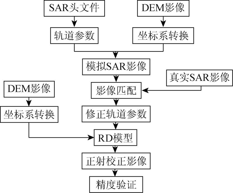
Abstract  

Evaluation the application potential of the new generation L-band sensor by ortho-rectifying of the PALSAR-2 image has an important significance. The error of orbital parameter in the rectification process will affect the final ortho-rectification precision. To tackle this problem, this paper proposes an ortho-rectification algorithm for PALSAR-2 image based on orbit parameters modulation and simplified calculation. Orbit parameters are modulated by registration of the simulate image and the real image. By using the modulated orbit parameters and simplified calculation of the range doppler(RD) model, ortho-rectification is performed. The method was applied to PALSAR-2 image and PALSAR image at the same time and it was compared with the PALSAR-2 ortho-rectification image without orbit parameters modulation. The result shows that the algorithm has strong operability and high geometric accuracy and that the new generation L-band sensor image’s rectification accuracy is higher, which further confirms that the new generation L-band sensor has better performance and greater application potential.

Keywords RD model      orbit parameter      ortho rectification      PALSAR-2     
:  TP79  
Corresponding Authors: Ping TANG     E-mail: liyy@radi.ac.cn;tangping@radi.ac.cn
Issue Date: 30 May 2018
Service
E-mail this article
E-mail Alert
RSS
Articles by authors
Yanyan LI
Ping TANG
Changmiao HU
Xiaojun SHAN
Cite this article:   
Yanyan LI,Ping TANG,Changmiao HU, et al. PALSAR-2 image ortho-rectification based on orbit parameters modulation[J]. Remote Sensing for Land & Resources, 2018, 30(2): 53-59.
URL:  
https://www.gtzyyg.com/EN/10.6046/gtzyyg.2018.02.07     OR     https://www.gtzyyg.com/EN/Y2018/V30/I2/53
Fig.1  Image point displacement
Fig.2  Flow chart of PALSAR-2 ortho-rectification
参数 ALOS-2 PALSAR-2 ALOS PALSAR
拍摄时间 2014-10-26,升轨 2010-12-16,升轨
中心经纬度/(°) E138.716,N35.579 E138.705,N35.803
载波频率/GHz 1.236 1.270
天底偏角/(°) 28 43.4
入射角/(°) 31.1 49.645
极化方式 全极化 HH
PRF 2 320.863 848.896
近地点斜距/km 719.291 987.469
参考坐标系统 ECR ECR
Tab.1  Brief introduction of the images in study area
Fig.3  PALSAR-2 image
Fig.4  DEM image
Fig.5  PALSAR-2 simulate image
Fig.6  PALSAR-2 ortho-rectification image
Fig.7  PALSAR rectification image
Fig.8  PALSAR-2 ortho-rectification image without orbit parameters modulation
点号 实际坐标 PALSAR -2校正影像 未经轨道修正的PALSAR -2校正影像
校正坐标 坐标差 校正坐标 坐标差
x y x y Δx Δy x y Δx Δy
1 301 470 3 920 022 301 461 3 920 021 9 1 301 459 3 920 028 11 6
2 299 655 3 921 460 299 649 3 921 451 6 9 299 647 3 921 451 8 9
3 297 900 3 904 394 297 898 3 904 392 2 2 297 890 3 904 382 10 12
4 289 693 3 931 157 289 686 3 931 150 7 7 289 686 3 931 141 7 16
5 289 290 3 931 063 289 293 3 931 065 3 2 289 299 3 931 066 9 3
6 288 781 3 930 926 288 776 3 930 929 5 3 288 766 3 930 914 15 12
7 288 387 3 930 908 288 385 3 930 899 2 9 288 383 3 930 899 4 9
8 283 306 3 929 923 283 293 3 929 922 13 1 283 293 3 929 910 13 13
9 283 238 3 930 228 283 234 3 930 221 4 7 283 234 3 930 221 4 7
10 281 628 3 928 258 281 626 3 928 266 2 8 281 620 3 928 266 8 8
11 277 290 3 909 780 277 283 3 909 787 7 7 277 272 3 909 787 18 7
12 274 895 3 934 615 274 889 3 934 618 6 3 274 889 3 934 625 6 10
13 269 652 3 932 515 269 653 3 932 514 1 1 269 659 3 932 503 7 12
14 267 860 3 927 380 267 852 3 927 384 8 4 267 845 3 927 384 15 4
15 267 434 3 924 644 267 437 3 924 652 3 8 267 437 3 924 652 3 8
Tab.2  Accuracy assessment of PALSAR -2 rectification images with orbit modulation and without orbit modulation(m)
[1] Hatooka Y, Kankaku Y, Arikawa Y , et al. First result from ALOS-2 operation[M] //Xiong X X,Shimoda H.Earth Observing Missions and Sensors:Development,Implementation,and Characterization III.Beijing,China:SPIE, 2014.
[2] Arikawa Y, Kankaku Y, Saruwatari H , et al.ALOS-2 launch and initial checkout result[C]//Proceedings of the SPIE Volume 9241,Sensors,Systems,and Next-Generation Satellites XVIII,SPIE Remote Sensing.Amsterdam,Netherlands:SPIE, 2014.
[3] 刘宇舟, 李梦华, 张路 , 等. ALOS-2PALSAR-2的干涉相干性分析——以黄河上游地区为例[J]. 测绘与空间地理信息, 2016,39(3):37-40,44.
[3] Liu Y Z, Li M H, Zhang L , et al. Interferometric coherence analysis of ALOS-2 PALSAR-2:In the upstream region of the Yellow River[J]. Geomatics and Spatial Information Technology, 2016,39(3):37-40,44.
[4] 敖祖锐 . 星载SAR影像模拟及其在正射校正中的应用研究[D]. 北京:首都师范大学, 2014.
[4] Ao Z R . Simulation of Space-Borne SAR and Its Application in Ortho-Rectification[D]. Beijing:Capital Normal University, 2014.
[5] 徐天蜀, 岳彩荣, 张王菲 . 山区星载ALOS PALSAR微波遥感图像的正射校正[J]. 农业工程学报, 2012,28(1):173-177.
doi: 10.3969/j.issn.1002-6819.2012.01.031 url: http://d.wanfangdata.com.cn/Periodical/nygcxb201201031
[5] Xu T S, Yue C R, Zhang W F . Orthographic calibration of space-borne ALOS PALSAR microwave remote sensing image in mountain area[J]. Transactions of the Chinese Society of Agricultural Engineering, 2012,28(1):173-177.
[6] 王庆, 曾琪明, 焦健 , 等. 基于DEM和查找表的高分辨率机载SAR图像正射校正[J].测绘通报, 2013(11):10-13.
url: http://www.cqvip.com/QK/93318X/201311/47862332.html
[6] Wang Q, Zeng Q M, Jiao J , et al. Orthorectification of high-resolution airborne SAR image based on DEM and the lookup table of RD model[J].Bulletin of Surveying and Mapping, 2013(11):10-13.
[7] 陈继伟, 曾琪明, 焦健 , 等. 利用轨道参数修正的无控制点星载SAR图像几何校正方法[J]. 测绘学报, 2016,45(12):1434-1440.
doi: 10.11947/j.AGCS.2016.20160182 url: http://d.wanfangdata.com.cn/Periodical/chxb201612006
[7] Chen J W, Zeng Q M, Jiao J , et al. Spaceborne SAR image geometric rectification method without ground control points using orbit parameters modulation[J]. Acta Geodaetica et Cartographica Sinica, 2016,45(12):1434-1440.
[8] Pan B, Liu L. Precise SAR satellite orbit parameters determination based on ground control points [C]//Proceedings of the 18th International Conference on Geoinformatics.Beijing,China:IEEE, 2010: 1-5.
[9] 陆静, 郭克成, 陆洪涛 . 星载SAR图像距离-多普勒定位精度分析[J]. 雷达科学与技术, 2009,7(2):102-106.
doi: 10.3969/j.issn.1672-2337.2009.02.005 url: http://www.cqvip.com/QK/87116X/200902/30263882.html
[9] Lu J, Guo K C, Lu H T . Analysis of R-D location precision in spaceborne SAR image[J]. Radar Science and Technology, 2009,7(2):102-106.
[10] Becek K . Assessing global digital elevation models using the runway method:The advanced spaceborne thermal emission and reflection radiometer versus the shuttle radar topography mission case[J]. IEEE Transactions on Geoscience and Remote Sensing, 2014,52(8):4823-4831.
doi: 10.1109/TGRS.2013.2285187 url: http://ieeexplore.ieee.org/document/6651798/
[11] 陈尔学 . 星载合成孔径雷达影像正射校正方法研究[D]. 北京:中国林业科学研究院, 2004.
[11] Chen E X . Study on Ortho-Rectification Methodology of Space-Borne Synthetic Aperture Radar Imagery[D]. Beijing:Chinese Academy of Forestry, 2004.
[12] Gelautz M, Frick H, Raggam J , et al. SAR image simulation and analysis of alpine terrain[J]. ISPRS Journal of Photogrammetry and Remote Sensing, 1998,53(1):17-38.
doi: 10.1016/S0924-2716(97)00028-2 url: http://linkinghub.elsevier.com/retrieve/pii/S0924271697000282
[13] Shimada M . Ortho-rectification and slope correction of SAR data using DEM and its accuracy evaluation[J]. IEEE Journal of Selected Topics in Applied Earth Observations and Remote Sensing, 2010,3(4):657-671.
doi: 10.1109/JSTARS.2010.2072984 url: http://ieeexplore.ieee.org/document/5597959/
[14] 张雷雨, 张飞 . 星载SAR影像的定位与几何纠正[J]. 计算机工程与应用, 2015,51(18):175-179.
doi: 10.3778/j.issn.1002-8331.1309-0338 url: http://www.cqvip.com/QK/91690X/201518/666175983.html
[14] Zhang L Y, Zhang F . Geopositioning and geometric rectification of spaceborne SAR images[J]. Computer Engineering and Applications, 2015,51(18):175-179.
[1] SONG Qi, FENG Chunhui, MA Ziqiang, WANG Nan, JI Wenjun, PENG Jie. Simulation of land use change in oasis of arid areas based on Landsat images from 1990 to 2019[J]. Remote Sensing for Natural Resources, 2022, 34(1): 198-209.
[2] REN Chaofeng, PU Yuchi, ZHANG Fuqiang. A method for extracting match pairs of UAV images considering geospatial information[J]. Remote Sensing for Natural Resources, 2022, 34(1): 85-92.
[3] ZANG Liri, YANG Shuwen, SHEN Shunfa, XUE Qing, QIN Xiaowei. A registration algorithm of images with special textures coupling a watershed with mathematical morphology[J]. Remote Sensing for Natural Resources, 2022, 34(1): 76-84.
[4] PAN Jianping, XU Yongjie, LI Mingming, HU Yong, WANG Chunxiao. Research and development of automatic detection technologies for changes in vegetation regions based on correlation coefficients and feature analysis[J]. Remote Sensing for Natural Resources, 2022, 34(1): 67-75.
[5] XUE Bai, WANG Yizhe, LIU Shuhan, YUE Mingyu, WANG Yiying, ZHAO Shihu. Change detection of high-resolution remote sensing images based on Siamese network[J]. Remote Sensing for Natural Resources, 2022, 34(1): 61-66.
[6] JIANG Na, CHEN Chao, HAN Haifeng. An optimization method of DEM resolution for land type statistical model of coastal zones[J]. Remote Sensing for Natural Resources, 2022, 34(1): 34-42.
[7] WU Fang, LI Yu, JIN Dingjian, LI Tianqi, GUO Hua, ZHANG Qijie. Application of 3D information extraction technology of ground obstacles in the flight trajectory planning of UAV airborne geophysical exploration[J]. Remote Sensing for Natural Resources, 2022, 34(1): 286-292.
[8] WANG Qian, REN Guangli. Application of hyperspectral remote sensing data-based anomaly extraction in copper-gold prospecting in the Solake area in the Altyn metallogenic belt, Xinjiang[J]. Remote Sensing for Natural Resources, 2022, 34(1): 277-285.
[9] LIU Wen, WANG Meng, SONG Ban, YU Tianbin, HUANG Xichao, JIANG Yu, SUN Yujiang. Surveys and chain structure study of potential hazards of ice avalanches based on optical remote sensing technology: A case study of southeast Tibet[J]. Remote Sensing for Natural Resources, 2022, 34(1): 265-276.
[10] YAO Jinxi, ZHANG Zhi, ZHANG Kun. An analysis of the characteristics, causes, and trends of spatio-temporal changes in vegetation in the Nuomuhong alluvial fan based on Google Earth Engine[J]. Remote Sensing for Natural Resources, 2022, 34(1): 249-256.
[11] WU Yijie, KONG Xuesong. Simulation and development mode suggestions of the spatial pattern of “ecology-agriculture-construction” land in Jiangsu Province[J]. Remote Sensing for Natural Resources, 2022, 34(1): 238-248.
[12] ZHANG Qinrui, ZHAO Liangjun, LIN Guojun, WAN Honglin. Ecological environment assessment of three-river confluence in Yibin City using improved remote sensing ecological index[J]. Remote Sensing for Natural Resources, 2022, 34(1): 230-237.
[13] HU Yingying, DAI Shengpei, LUO Hongxia, LI Hailiang, LI Maofen, ZHENG Qian, YU Xuan, LI Ning. Spatio-temporal change characteristics of rubber forest phenology in Hainan Island during 2001—2015[J]. Remote Sensing for Natural Resources, 2022, 34(1): 210-217.
[14] SUN Yiming, ZHANG Baogang, WU Qizhong, LIU Aobo, GAO Chao, NIU Jing, HE Ping. Application of domestic low-cost micro-satellite images in urban bare land identification[J]. Remote Sensing for Natural Resources, 2022, 34(1): 189-197.
[15] ZHENG Xiucheng, ZHOU Bin, LEI Hui, HUANG Qiyu, YE Haolin. Extraction and spatio-temporal change analysis of the tidal flat in Cixi section of Hangzhou Bay based on Google Earth Engine[J]. Remote Sensing for Natural Resources, 2022, 34(1): 18-26.
Viewed
Full text


Abstract

Cited

  Shared   
  Discussed   
京ICP备05055290号-2
Copyright © 2017 Remote Sensing for Natural Resources
Support by Beijing Magtech