|
|
 |
|

|
|
|
Research on airborne remote sensing emergency flight organization strategy in natural disaster |
| Kai CHEN, Chengfa FANG, Ru LI |
| Institute of Remote Sensing and Digital Earth Airborne Remote Sensing Center, Chinese Academy of Sciences, Beijing 100094, China |
|
|
|
|
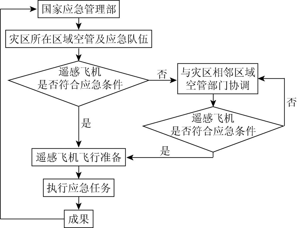
Abstract In view of the situation that airborne remote sensing (RS) has the problem of low efficiency and disorder organization in natural disasters emergency work, the authors analyzed the organizational elements of airborne RS emergency flight and, in combination with the current situation of airborne remote sensing profession in China, put forward the flight organization mode of the regional collaboration, and established emergency merit-based model based on analytic hierarchy process(AHP). The mode considers five indexes, i.e., flight time, airplane performance, operating area, remote sensing equipment, data transfer and process capability. Practice shows the feasibility and efficiency of the regional collaboration mode and merit-based model.
|
| Keywords
disaster emergency
airborne remote sensing
regional collaboration
merit-based model
|
|
|
|
Issue Date: 10 September 2018
|
|
|
| [1] |
王绍玉, 唐桂娟 . 综合自然灾害风险管理理论依据探析[J]. 自然灾害学报, 2009,18(2):33-38.
doi: 10.3969/j.issn.1004-4574.2009.02.005
url: http://d.wanfangdata.com.cn/Periodical/zrzhxb200902005
|
| [1] |
Wang S Y, Tang G J . Exploratory analysis of theoretical basis for integrated natural disaster risk management[J]. Journal of Natural Disasters, 2009,18(2):33-38.
|
| [2] |
魏成阶, 刘亚岚, 王世新 , 等. 四川汶川大地震震害遥感调查与评估[J]. 遥感学报, 2008,12(5):673-682.
|
| [2] |
Wei C J, Liu Y L, Wang S X , et al. Investigation and assessment of damage in earthquake Wenchuan Sichuan quake based on remote sensing[J]. Journal of Remote Sensing, 2008,12(5):673-682.
|
| [3] |
尹鹏飞, 尹球, 陈兴峰 , 等. 无人机航空遥感技术在震后灾情调查中的应用[J]. 激光与光电子学进展, 2010,47(11):112802.
url: http://www.opticsjournal.net/Articles/Abstract?aid=OJ101015000005w3z6C9
|
| [3] |
Yin P F, Yin Q, Chen X F , et al. Unmanned aerial vehicle aerial remote sensing techniques and its application on post-earthquake disaster investigation[J]. Laser and Optoelectronics Progress, 2010,47(11):112802.
|
| [4] |
樊治平, 刘洋, 沈荣鉴 . 基于前景理论的突发事件应急响应的风险决策方法[J]. 系统工程理论与实践, 2012,32(5):977-984.
doi: 10.3969/j.issn.1000-6788.2012.05.009
url: http://d.wanfangdata.com.cn/Periodical_xtgcllysj201205009.aspx
|
| [4] |
Fan Z P, Liu Y, Shen R J . Risk decision analysis method for emergency response based on prospect theory[J]. Systems Engineering-Theory and Practice, 2012,32(5):977-984.
|
| [5] |
夏正洪, 潘卫军, 林瑞春 , 等. 重大灾害条件下的航空应急救援效率研究[J]. 计算机工程与设计, 2012,33(3):1251-1256.
doi: 10.3969/j.issn.1000-7024.2012.03.081
url: http://d.wanfangdata.com.cn/Periodical/jsjgcysj201203081
|
| [5] |
Xia Z H, Pan W J, Lin R C , et al. Research on efficiency of aviation emergency rescue under major disasters[J]. Computer Engineering and Design, 2012,33(3):1251-1256.
|
| [6] |
Turker M, San B T . Detection of collapsed buildings caused by the 1999 Izmit,Turkey earthquake through digital analysis of post-event aerial photographs[J]. International Journal of Remote Sensing, 2004,25(21):4701-4714.
doi: 10.1080/01431160410001709976
url: http://www.tandfonline.com/doi/abs/10.1080/01431160410001709976
|
| [7] |
朱博勤, 魏成阶, 张渊智 . 航空遥感地震灾害信息的快速提取[J]. 自然灾害学报, 1998,7(1):34-39.
url: http://www.cnki.com.cn/Article/CJFDTotal-ZRZH801.005.htm
|
| [7] |
Zhu B Q, Wei C J, Zhang Y Z . The quick extracting of earthquake disaster data by aerial remote sensing survey[J]. Journal of Natural Disasters, 1998,7(1):34-39.
|
| [8] |
赵福军, 蔡山, 陈曦 , 等. 遥感震害快速评估技术在汶川地震中的应用[J]. 自然灾害学报, 2010,19(1):1-7.
|
| [8] |
Zhao F J, Cai S, Chen X , et al. Application of rapid seismic damage assessment based on remote sensing to Wenchuan earthquake[J]. Journal of Natural Disasters, 2010,19(1):1-7.
|
| [9] |
王丽涛, 王世新, 周艺 , 等. 青海玉树地震灾情遥感应急监测分析[J]. 遥感学报, 2010,14(5):1060-1066.
doi: 10.11834/jrs.20100517
url: http://d.wanfangdata.com.cn/Periodical_ygxb201005017.aspx
|
| [9] |
Wang L T, Wang S X, Zhou Y , et al. Urgent monitoring and analysis on Yushu earthquake using remote sensing[J]. Journal of Remote Sensing, 2010,14(5):1060-1066.
|
| [10] |
郭兆成, 童立强, 郑雄伟 , 等. 四川芦山地震次生地质灾害遥感调查及灾害特征初探[J]. 国土资源遥感, 2014,26(3):99-105.doi: 10.6046/gtzyyg.2014.03.16.
doi: 10.6046/gtzyyg.2014.03.16
|
| [10] |
Guo Z C, Tong L Q, Zheng X W , et al. Remote sensing survey of secondary geological disasters triggered by Lushan earthquake in Sichuan Province and tentative discussion on disaster characteristics[J]. Remote Sensing for Land and Resources, 2014,26(3):99-105.doi: 10.6046/gtzyyg.2014.03.16.
|
| [11] |
刘浪 . 非常规突发事件航空应急物流响应的军地协调机制[J]. 北京理工大学学报(社会科学版), 2012,14(2):93-99.
|
| [11] |
Liu L . Research on coordination mechanism between military and locals of aviation emergency logistics response for unconventional disruption[J]. Journal of Beijing Institute of Technology (Social Sciences Edition), 2012,14(2):93-99.
|
| [12] |
雷添杰, 李长春, 何孝莹 . 无人机航空遥感系统在灾害应急救援中的应用[J]. 自然灾害学报, 2011,20(1):178-183.
|
| [12] |
Lei T J, Li C C, He X Y . Application of aerial remote sensing of pilotless aircraft to disaster emergency rescue[J]. Journal of Natural Disasters, 2011,20(1):178-183.
|
| [13] |
王小燕, 任国业, 刘卫东 , 等. 基于遥感和GIS的洪水灾情快速统计模拟技术[J]. 广西师范大学学报(自然科学版), 2014,32(4):32-38.
|
| [13] |
Wang X Y, Ren G Y, Liu W D , et al. Quick flood disaster statistics stats simulation technology based on the remote sensing and GIS technology[J]. Journal of Guangxi Normal University (Natural Science Edition), 2014,32(4):32-38.
|
| [14] |
裴文娟, 陈文凯, 安培俊 . 地震应急中制约遥感应用因素分析[J]. 高原地震, 2014,26(1):36-45.
|
| [14] |
Pei W J, Chen W K, An P J . Analysis on application factors for the remote sensing in earthquake emergency assessment[J]. Plateau Earthquake Research, 2014,26(1):36-45.
|
| [15] |
甘应爱, 田丰, 李维铮 , 等. 运筹学[M]. 3版.北京: 清华大学出版社, 2005: 6.
|
| [15] |
Gan Y A, Tian F, Li W Z , et al. Operational Research[M].3rd ed. Beijing: Tsinghua University Press, 2005: 6.
|
| [16] |
郭金玉, 张忠彬, 孙庆云 . 层次分析法的研究与应用[J]. 中国安全科学学报, 2008,18(5):148-153.
|
| [16] |
Guo J Y, Zhang Z B, Sun Q Y . Study and applications of analytic hierarchy process[J]. China Safety Science Journal, 2008,18(5):148-153.
|
| [17] |
Saaty T L . The Analytic Hierarchy Process[M]. New York:McGraw-Hill, 1980.
|
|
Viewed |
|
|
|
Full text
|
|
|
|
|
Abstract
|
|
|
|
|
Cited |
|
|
|
|
| |
Shared |
|
|
|
|
| |
Discussed |
|
|
|
|
 2018,
Vol. 30
2018,
Vol. 30