|
|
 |
|

|
|
|
Research on the DEM-assisted offset tracking technique applied to glaciers movement monitoring |
Qun WANG1, Jinghui FAN2( ), Wei ZHOU1, Weilin YUAN2, Liqiang TONG2, Zhaocheng GUO2 ), Wei ZHOU1, Weilin YUAN2, Liqiang TONG2, Zhaocheng GUO2 |
1. School of Land Science and Technology, China University of Geosciences, Beijing 100083, China
2. China Aero Geophysical Survey and Remote Sensing Centre for Land and Resources, Beijing 100083, China |
|
|
|
|
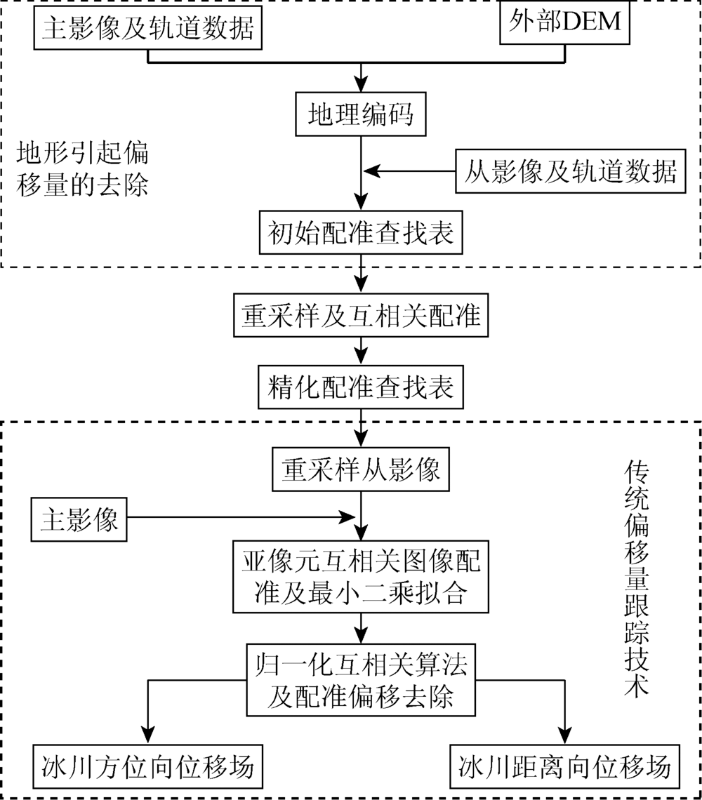
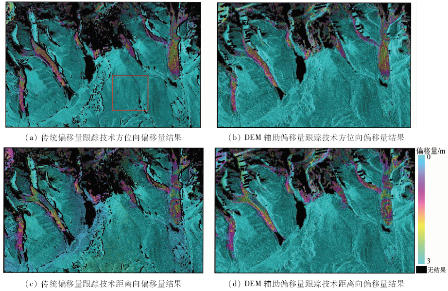
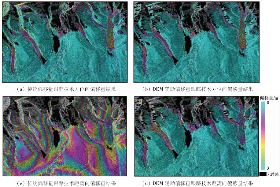
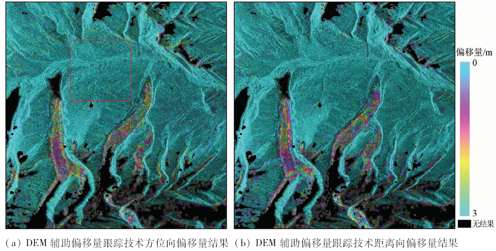
Abstract To improve the offset results influenced by large spatial baseline and topography when traditional offset tracking technique is applied to extracting mountain glaciers surface movement, the authors studied a DEM-assisted offset tracking technique. Two pairs of TerraSAR-X images with different baseline lengths which cover the eastern section of Chomo Lhari Mountains located in Kangmar and Nagarze County of Tibet were selected to test the traditional and external DEM-assisted offset tracking techniques in this paper. And the offset results of the two methods in ice-free region were comparatively studied. A pair of COSMO-SkyMed images acquired by different beam modes, with different incidences and covers, were selected and processed with DEM-assisted offset tracking technique. It is shown that the DEM-assisted offset tracking technique could obtain more reliable offset results than the traditional technique where the terrain is steep and the spatial baseline is large. The technique can also apply to SAR images which have different beam modes and can make more SAR data useful for glaciers surface movement monitoring.
|
| Keywords
offset tracking technique
glaciers surface movement
large spatial baseline
topographic effect
external DEM
TerraSAR-X
COSMO-SkyMed
|
|
|
|
Corresponding Authors:
Jinghui FAN
E-mail: jhfan2004@qq.com
|
|
Issue Date: 10 September 2018
|
|
|
| [1] |
Zhou J M, Li Z, Guo W Q . Estimation and analysis of the surface velocity field of mountain glaciers in Muztag Ata using satellite SAR data[J]. Environmental Earth Sciences, 2014,71(8):3581-3592.
doi: 10.1007/s12665-013-2749-5
url: http://link.springer.com/10.1007/s12665-013-2749-5
|
| [2] |
谢自楚, 刘潮海 . 冰川学导论[M]. 上海: 上海科学普及出版社, 2010: 17-18.
|
| [2] |
Xie Z C, Liu C H. Introduction to Glacier[M]. Shanghai: Shanghai Populao Science Press, 2010: 17-18.
|
| [3] |
Bolch T, Buchroithner M F, Peters J , et al. Identification of glacier motion and potentially dangerous glacial lakes in the Mt.Everest region/Nepal using spaceborne imagery[J]. Natural Hazards and Earth System Sciences, 2008,8(6):1329-1340.
doi: 10.5194/nhess-8-1329-2008
url: https://www.nat-hazards-earth-syst-sci.net/8/1329/2008/
|
| [4] |
郭兆成, 童立强, 周成灿 , 等. 基于遥感图像分析对金错冰川湖溃决泥石流事件的验证[J]. 国土资源遥感, 2016,28(1):152-158.doi: 10.6046/gtzyyg.2016.03.15.
doi: 10.6046/gtzyyg.2016.01.22
url: http://d.wanfangdata.com.cn/Periodical/gtzyyg201601022
|
| [4] |
Guo Z C, Tong L Q, Zhou C C , et al. Verification of glacial lake outburst debris flow events in Jincuo Lake of Tibet based on remote sensing image analysis[J]. Remote Sensing for Land and Resources, 2016,28(1):152-158.doi: 10.6046/gtzyyg.2016.03.15.
|
| [5] |
Kääb A . Combination of SRTM3 and repeat ASTER data for deriving alpine glacier flow velocities in the Bhutan Himalaya[J]. Remote Sensing of Environment, 2005,94(4):463-474.
doi: 10.1016/j.rse.2004.11.003
url: http://linkinghub.elsevier.com/retrieve/pii/S0034425704003475
|
| [6] |
邢宇 . 青藏高原32年湿地对气候变化的空间响应[J]. 国土资源遥感, 2015,27(3):99-107.doi: 10.6046/gtzyyg.2015.03.17.
doi: 10.6046/gtzyyg.2015.03.17
|
| [6] |
Xing Y . Spatial responses of wetland change to climate in 32 years in Qinghai-Tibet Plateau[J]. Remote Sensing for Land and Resources, 2015,27(3):99-107.doi: 10.6046/gtzyyg.2015.03.17.
|
| [7] |
廖明生, 王腾 . 时间序列InSAR技术与应用[M]. 北京: 科学出版社, 2014: 1-2.
|
| [7] |
Liao M S, Wang T. Time Series InSAR Technology and Application[M]. Beijing: Science Press, 2014: 1-2.
|
| [8] |
Huang L, Li Z . Comparison of SAR and optical data in deriving glacier velocity with feature tracking[J]. International Journal of Remote Sensing, 2011,32(10):2681-2698.
doi: 10.1080/01431161003720395
url: http://www.tandfonline.com/doi/abs/10.1080/01431161003720395
|
| [9] |
Luckman A, Quincey D, Bevan S . The potential of satellite radar interferometry and feature tracking for monitoring flow rates of Himalayan glaciers[J]. Remote Sensing of Environment, 2007,111(2/3):172-181.
doi: 10.1016/j.rse.2007.05.019
url: http://linkinghub.elsevier.com/retrieve/pii/S0034425707002842
|
| [10] |
Strozzi T, Luckman A, Murray T , et al. Glacier motion estimation using SAR offset-tracking procedures[J]. IEEE Transactions on Geoscience and Remote Sensing, 2002,40(11):2384-2391.
doi: 10.1109/TGRS.2002.805079
url: http://ieeexplore.ieee.org/document/1166597/
|
| [11] |
Goldstein R M, Engelhardt H, Kamb B , et al. Satellite radar interferometry for monitoring ice sheet motion:Application to an antarctic ice stream[J]. Science, 1993,262(5139):1525-1530.
doi: 10.1126/science.262.5139.1525
url: http://www.sciencemag.org/cgi/doi/10.1126/science.262.5139.1525
|
| [12] |
Bechor N B D, Zebker H A . Measuring two-dimensional movements using a single InSAR pair[J]. Geophysical Research Letters, 2006,33(16):L16311.
doi: 10.1029/2006GL026883
url: http://doi.wiley.com/10.1029/2006GL026883
|
| [13] |
王思胜, 江利明, 孙永玲 , 等. 基于ALOS PALSAR数据的山地冰川流速估算方法比较——以喀喇昆仑地区斯克洋坎力冰川为例[J]. 国土资源遥感, 2016,28(2):54-61.doi: 10.6046/gtzyyg.2016.02.09.
doi: 10.6046/gtzyyg.2016.02.09
url: http://d.wanfangdata.com.cn/Periodical/gtzyyg201602009
|
| [13] |
Wang S S, Jiang L M, Sun Y L , et al. Evaluation of methods for deriving mountain glacier velocities with ALOS PALSAR images:A case study of Skyang glacier in central Karakoram[J]. Remote Sensing for Land and Resources, 2016,28(2):54-61.doi: 10.6046/gtzyyg.2016.02.09.
|
| [14] |
Riveros N, Euillades L, Euillades P , et al. Offset tracking procedure applied to high resolution SAR data on Viedma glacier,Patagonian Andes,Argentina[J]. Advances in Geosciences, 2013,35:7-13.
doi: 10.5194/adgeo-35-7-2013
url: https://www.adv-geosci.net/35/7/2013/
|
| [15] |
Strozzi T, Kouraev A, Wiesmann A , et al. Estimation of Arctic glacier motion with satellite L-band SAR data[J]. Remote Sensing of Environment, 2008,112(3):636-645.
doi: 10.1016/j.rse.2007.06.007
url: http://linkinghub.elsevier.com/retrieve/pii/S0034425707002271
|
| [16] |
Yan S Y, Liu G, Wang Y J , et al. Accurate determination of glacier surface velocity fields with a DEM-assisted pixel-tracking technique from SAR imagery[J]. Remote Sensing, 2015,7(8):10898-10916.
doi: 10.3390/rs70810898
url: http://www.mdpi.com/2072-4292/7/8/10898
|
| [17] |
Yan S Y, Guo H D, Liu G , et al. Mountain glacier displacement estimation using a DEM-assisted offset tracking method with ALOS/PALSAR data[J]. Remote Sensing Letters, 2013,4(5):494-503.
doi: 10.1080/2150704X.2012.754561
url: http://www.tandfonline.com/doi/abs/10.1080/2150704X.2012.754561
|
| [18] |
Yan S Y, Liu G, Wang Y J , et al. Glacier surface motion pattern in the Eastern part of West Kunlun Shan estimation using pixel-tracking with PALSAR imagery[J]. Environmental Earth Sciences, 2015,74(3):1871-1881.
doi: 10.1007/s12665-015-4645-7
url: http://link.springer.com/10.1007/s12665-015-4645-7
|
| [19] |
邓方慧, 周春霞, 王泽民 , 等. 利用偏移量跟踪测定Amery冰架冰流汇合区的冰流速[J]. 武汉大学学报(信息科学版), 2015,40(7):901-906.
doi: 10.13203/j.whugis20130653
url: http://d.wanfangdata.com.cn/Periodical_whchkjdxxb201507009.aspx
|
| [19] |
Deng F H, Zhou C X, Wang Z M , et al. Ice-flow velocity derivation of the confluence zone of the Amery ice shelf using offset-tracking method[J]. Geomatics and Information Science of Wuhan University, 2015,40(7):901-906.
|
| [20] |
郑茜, 孙建宝, 张永 . 基于Landsat-8时间序列影像分析西昆仑山地区冰川滑移特征[J]. 大地测量与地球动力学, 2016,36(7):604-608.
|
| [20] |
Zheng Q, Sun J B, Zhang Y . Fast and uniformly slipping Western-Kunlun glaciers from time-series deformation analysis using periodically captured Landsat-8 imagery[J]. Journal of Geodesy and Geodynamics, 2016,36(7):604-608.
|
| [21] |
闫世勇 . 山地冰川表面运动雷达遥感监测方法研究[D]. 北京:中国科学院大学, 2013: 53-55.
|
| [21] |
Yan S Y . Research on Extraction of Alpine Glacier Surface Movement by SAR Remote Sensing[D]. Beijing:University of Chinese Academy of Sciences, 2013: 53-55.
|
| [22] |
Sansosti E, Berardino P, Manunta M , et al. Geometrical SAR image registration[J]. IEEE Transactions on Geoscience and Remote Sensing, 2006,44(10):2861-2870.
doi: 10.1109/TGRS.2006.875787
url: http://ieeexplore.ieee.org/document/1704979/
|
| [23] |
GAMMA Remote Sensing . Differential Interferometry and Geocoding Software-DIFF&GEO(Geocoding and Image Registration)[R]. Switzerland:GAMMA Remote Sensing AG, 2008.
|
| [24] |
戎丹雅, 吴秀山, 冉启华 , 等. 冰湖溃决洪水演进模拟[J]. 水土保持, 2014,2(3):29-36.
doi: 10.12677/ojswc.2014.23003
url: http://www.oalib.com/paper/1571309
|
| [24] |
Rong D Y, Wu X S, Ran Q H , et al. Evolution simulation of glacial lake outburst flood[J]. Open Journal of Soil and Water Conservation, 2014,2(3):29-36.
|
| [25] |
刘春玲, 童立强, 祁生文 , 等. 喜马拉雅山地区冰川湖溃决灾害隐患遥感调查及影响因素分析[J]. 国土资源遥感, 2016,28(3):110-115.doi: 10.6046/gtzyyg.2016.03.18.
doi: 10.6046/gtzyyg.2016.03.18
url: http://d.wanfangdata.com.cn/Periodical/gtzyyg201603018
|
| [25] |
Liu C L, Tong L Q, Qi S W , et al. Remote sensing investigation and influence factor analysis of glacier lake outburst potential in the Himalayas[J]. Remote Sensing for Land and Resources, 2016,28(3):110-115.doi: 10.6046/gtzyyg.2016.03.18.
|
| [26] |
倪维平, 边辉, 严卫东 , 等. TerraSAR-X雷达卫星的系统特性与应用分析[J]. 雷达科学与技术, 2009,7(1):29-34,58.
|
| [26] |
Ni W P, Bian H, Yan W D , et al. System characteristics and application analysis of TerraSAR-X Radar satellite[J]. Radar Science and Technology, 2009,7(1):29-34,58.
|
| [27] |
Italian Space Agency.COSMO-SkyMed Mission and Products Description[EB/OL].[ 2016- 05- 31]. .
url: http://www.e-geos.it/cosmo-skymed.html
|
| [28] |
USGS Earth Resource Observation and Science(EROS) Center.Global Data Explorer(GDEx) Data Access User Guide[EB/OL].[2016-04]..
url: https://gdex.cr.usgs.gov/gdex/
|
|
Viewed |
|
|
|
Full text
|
|
|
|
|
Abstract
|
|
|
|
|
Cited |
|
|
|
|
| |
Shared |
|
|
|
|
| |
Discussed |
|
|
|
|
 2018,
Vol. 30
2018,
Vol. 30