|
|
 |
|

|
|
|
Land subsidence monitoring based on differential interferometry using time series of high-resolution TerraSAR-X images and monitoring precision verification |
YU Bing1,2,3,4( ), TAN Qingxue1, LIU Guoxiang5, LIU Fuzhen1, ZHOU Zhiwei4, HE Zhiyong1 ), TAN Qingxue1, LIU Guoxiang5, LIU Fuzhen1, ZHOU Zhiwei4, HE Zhiyong1 |
1. School of Civil Engineering and Geomatics, Southwest Petroleum University, Chengdu 610500, China
2. Institute of Petroleum and Natural Gas Spatial Information Engineering, Southwest Petroleum University, Chengdu 610500, China
3. State Key Laboratory of Oil and Gas Reservoir Geology and Exploitation, Southwest Petroleum University, Chengdu 610500, China
4. State Key Laboratory of Geodesy and Earth's Dynamics, Innovation Academy for Precision Measurement Science and Technology, Chinese Academy of Sciences, Wuhan 430077, China
5. Faculty of Geosciences and Environmental Engineering, Southwest Jiaotong University, Chengdu 611756, China |
|
|
|
|
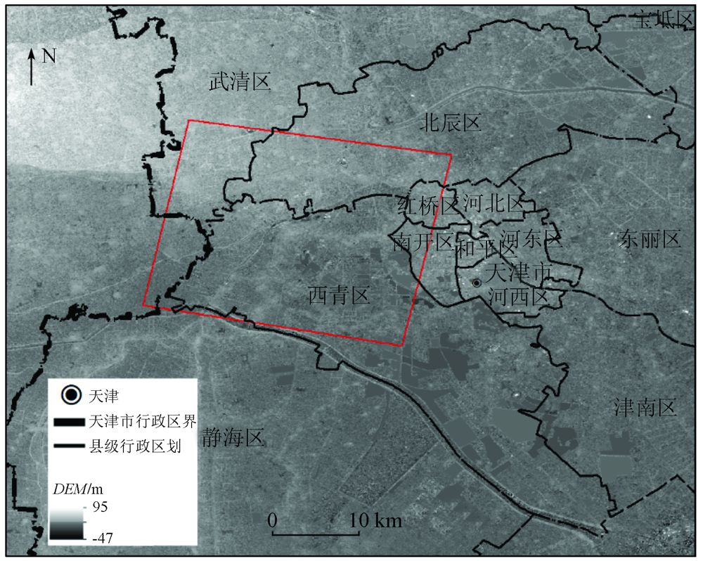
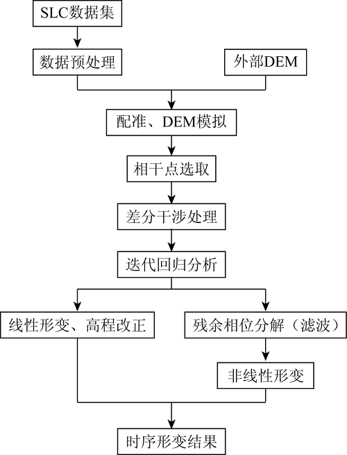
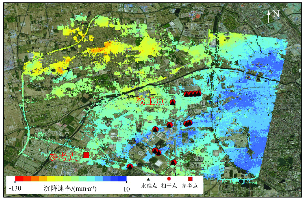
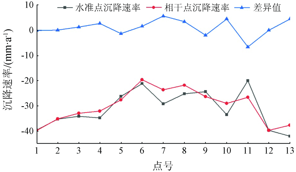
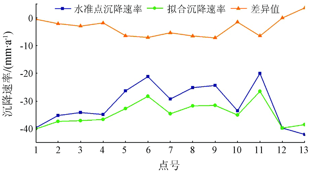
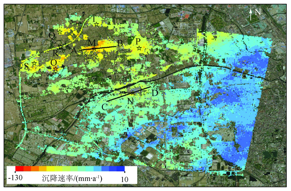
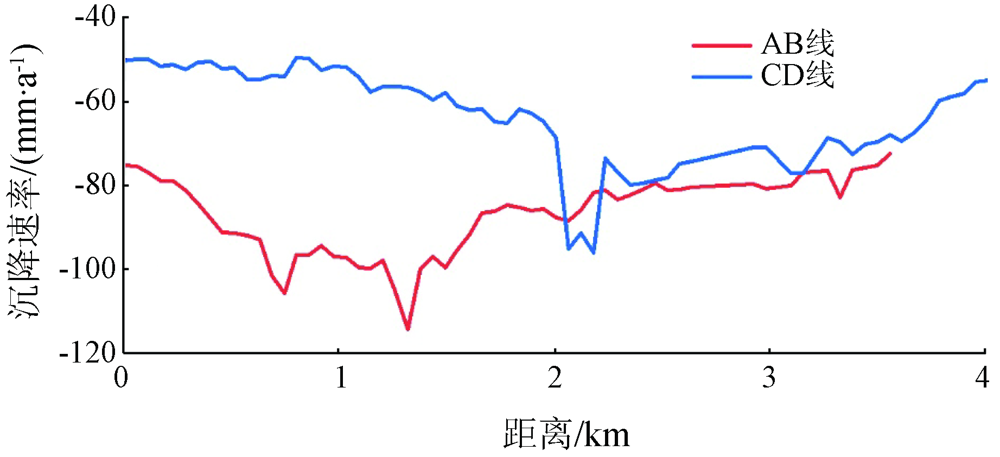
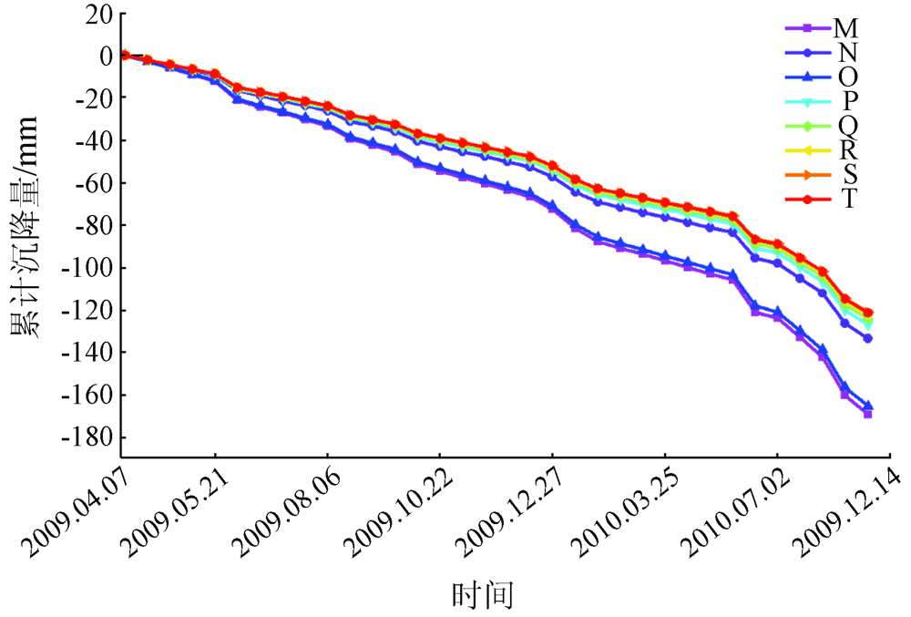
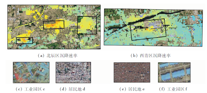
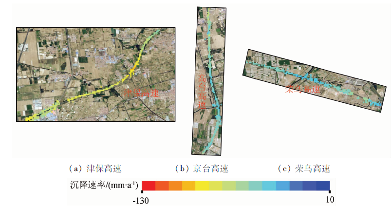
Abstract Urban land subsidence is a kind of slowly developing geological disaster and has sustained negative impacts on the social economy and human life. Therefore, it is of great significance to carry out effective and wide-area urban subsidence monitoring. With 34 high-resolution TerraSAR-X SAR images obtained from April 07, 2009 to December 14, 2010 as data sources, the land subsidence in Tianjin City was monitored using the differential interferometry of time series based on interferometric point target analysis (IPTA) in this study. Then the monitoring precision was verified using the precise leveling data, and a verification method of subsidence time series based on least-squares fitting was adopted. Finally, subsidence analysis and interpretation were carried out based on the verification results. Compared to the leveling data, the root mean square errors of the subsidence rates obtained using IPTA and that using the least squares-fitting of time series were 3.15 mm/a and -3.25 mm/a, respectively. According to the analysis of subsidence results, the overall subsidence of the study area is significantly uneven, the maximum subsidence rate is -128.41 mm/a, and the spatial-temporal distribution of the land subsidence correlates highly with surface cover types and groundwater exploitation.
|
| Keywords
TerraSAR-X
time series differential interferometry
land subsidence monitoring and analysis
precision verification
|
|
|
|
Issue Date: 23 December 2021
|
|
|
| [1] |
Solari L, Ciampalini A, Raspini F, et al. Combined use of C-and X-band SAR data for subsidence monitoring in an urban area[J]. Geosciences, 2017,7(21):1-17.
doi: 10.3390/geosciences7010001
url: http://www.mdpi.com/2076-3263/7/1/1
|
| [2] |
于冰. 高分辨率相干散射体雷达干涉建模及形变信息提取方法[D]. 成都:西南交通大学, 2015.
|
| [2] |
Yu B. High resolution coherent scatterer Radar interferometric modeling and deformation information extraction method[D]. Chengdu:Southwest Jiaotong University, 2015.
|
| [3] |
段晓峰, 许学工, 王若柏. 天津沿海地区地面沉降及其影响因素[J]. 北京大学学报(自然科学版), 2014,50(6):1071-1076.
|
| [3] |
Duan X F, Xu X G, Wang R B. Land subsidence and its influencing factors in Tianjin coastal area[J]. Journal of Peking University(Natural Science Edition), 2014,50(6):1071-1076.
|
| [4] |
张洪涛. 城市地质工作——国家经济建设和社会发展的重要支撑(代序)[J]. 地质通报, 2003(8):549-550.
|
| [4] |
Zhang H T. Urban geological work:An important support for national economic construction and social development[J]. Geological Bulletin, 2003(8):549-550.
|
| [5] |
曹群, 陈蓓蓓, 宫辉力, 等. 基于SBAS和IPTA技术的京津冀地区地面沉降监测[J]. 南京大学学报(自然科学), 2019,55(3):381-391.
|
| [5] |
Cao Q, Chen B B, Gong H L, et al. Land subsidence monitoring in Beijing Tianjin Hebei region based on SBAS and IPTA technology[J]. Journal of Nanjing University(Natural Science), 2019,55(3):381-391.
|
| [6] |
董克刚, 周俊, 于强, 等. 天津市地面沉降的特征及其危害[J]. 地质灾害与环境保护, 2007(1):67-70.
|
| [6] |
Dong K G, Zhou J, Yu Q, et al. Characteristics and hazards of land subsidence in Tianjin[J]. Geological Hazards and Environmental Protection, 2007(1):67-70.
|
| [7] |
于海若, 宫辉力, 陈蓓蓓, 等. 京津冀地区地面沉降研究进展与思考[J]. 测绘科学, 2020,45(4):125-133,141.
|
| [7] |
Yu H R, Gong H L, Chen B B, et al. Land subsidence research progress and thinking in Beijing Tianji Hebei region[J]. Surveying and Mapping Science, 2020,45(4):125-133,141.
|
| [8] |
袁悦, 贾丽云, 张绪教, 等. 基于SBAS-InSAR技术的海口地区地面沉降监测及机理分析[J]. 地理与地理信息科学, 2020,36(5):56-64.
|
| [8] |
Yuan Y, Jia L Y, Zhang X J, et al. Land subsidence monitoring and mechanism analysis in Haikou area based on SBAS-InSAR technology[J]. Geography and Geographic Information Science, 2020,36(5):56-64.
|
| [9] |
廖明生, 卢丽君, 王艳, 等. 基于点目标分析的InSAR技术检测地表微小形变的研究[J]. 城市地质, 2006(2):38-41.
|
| [9] |
Liao M S, Lu L J, Wang Y, et al. Study on InSAR technology for detecting surface micro deformation based on point target analysis[J]. Urban Geology, 2006(2):38-41.
|
| [10] |
丁荣荣, 徐佳, 林晓彬, 等. 基于高分辨率TerraSAR-X影像的PSInSAR地表形变监测[J]. 国土资源遥感, 2015,27(4):158-164.doi: 10.6046/gtzyyg.2015.04.24.
doi: 10.6046/gtzyyg.2015.04.24
|
| [10] |
Ding R R, Xu J, Lin X B, et al. Surface deformation monitoring by PSInSAR based on high resolution TerraSAR-X image[J]. Remote Sensing of Land and Resources, 2015,27(4):158-164.doi: 10.6046/gtzyyg.2015.04.24.
doi: 10.6046/gtzyyg.2015.04.24
|
| [11] |
Caló F, Notti D, Galve J P, et al. DInSAR-based detection of land subsidence and correlation with groundwater depletion in Konya Plain,Turkey[J]. Remote Sensing, 2017,9(1):1-25.
|
| [12] |
Alam M S, Kumar D, Chatterjee R S, et al. Assessment of land surface subsidence due to underground metal mining using integrated spaceborne repeat-pass differential interferometric synthetic aperture Radar (DInSAR) technique and ground based observations[J]. Journal of the Indian Society of Remote Sensing, 2018,46(10):1569-1580.
doi: 10.1007/s12524-018-0810-2
url: https://doi.org/10.1007/s12524-018-0810-2
|
| [13] |
Vidal-Páez P, Derauw D, Fernandez-Sarría A, et al. Monitoring of mining subsidence in a sector of central chile through the processing of a time series of Sentinel 1 images using differential interferometry techniques (DInSAR)[J]. Proceedings, 2019,19(1):1-4.
doi: 10.3390/proceedings2019019001
url: https://www.mdpi.com/2504-3900/19/1/1
|
| [14] |
Pawluszek-Filipiak K, Borkowski A. Integration of DInSAR and SBAS techniques to determine mining-related deformations using Sentinel-1 data:The case study of Rydułtowy mine in Poland[J]. Remote Sensing, 2020,12(2):1-23.
doi: 10.3390/rs12010001
url: https://www.mdpi.com/2072-4292/12/1/1
|
| [15] |
常素娟. 天津市公共租赁房住区生态环境设计研究[D]. 天津:河北工业大学, 2015.
|
| [15] |
Chang S J. Study on ecological environment design of public rental housing in Tianjin[D]. Tianjin:Hebei University of Technology, 2015.
|
| [16] |
Yi L X, Zhang F, Xu H, et al. Land subsidence in Tianjin,China[J]. Environmental Earth Sciences, 2011,62(6):1151-1161.
doi: 10.1007/s12665-010-0604-5
url: http://link.springer.com/10.1007/s12665-010-0604-5
|
| [17] |
刘晓杰, 赵超英, 康亚, 等. 茂县滑坡形变的Sentinel-1数据分析[J]. 测绘科学, 2019,44(4):55-59,71.
|
| [17] |
Liu X J, Zhao C Y, Kang Y, et al. Sentinel-1 data analysis of landslide deformation in Maoxian County[J]. Surveying and Mapping Science, 2019,44(4):55-59,71.
|
|
Viewed |
|
|
|
Full text
|
|
|
|
|
Abstract
|
|
|
|
|
Cited |
|
|
|
|
| |
Shared |
|
|
|
|
| |
Discussed |
|
|
|
|
 2021,
Vol. 33
2021,
Vol. 33