|
|
 |
|

|
|
|
An analysis of spatial-temporal coupling relationship between seawater intrusion and regional coastline changes in south coast of Laizhou Bay from 1979 to 2012 |
| Yonghui MENG, Jining WANG, Lixia ZHANG, Mei LUO |
| Shandong Province Geological Environment Monitoring Station, Jinan 250014, China |
|
|
|
|
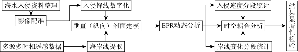
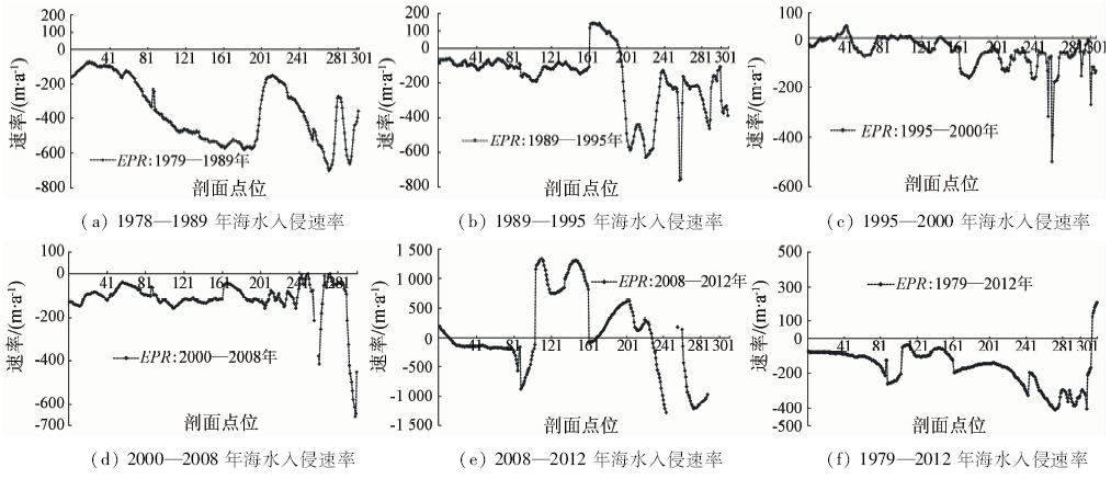
Abstract Based on the regional seawater intrusion observation data and the remote sensing integrated observation data, the authors examined spatio-temporal dynamic change characteristics and mode of seawater intrusion and coastline evolution in the south coast zone of Laizhou Bay. Firstly, multi-period remote sensed images were used for monitoring of the regional coastline changes from 1979 to 2012. And then, the temporal and spatial features of seawater intrusion were reconstructed by digital vectorization from the historical filed survey maps. On the basis of above information, the EPR model was introduced and the spatial-temporal coupling mechanism between the seawater intrusion and coastline changes was studied and analyzed. Some conclusions have been reached: ① The regional seawater intrusion experienced a change process from rapid to slow, and the rate of invasion was slowing down after 1990. The front of intrusion line was stable since 1995 and retreated from 2008 to 2012. ② The coastal coastline is dominated by the coastal retreating coastline, besides the local artificial coastline. ③ There is a strong coupling relationship between the change of seawater intrusion frontline and coastline in time and space. The correlation coefficient is 0.407, at the significant level of P less than 0.01 (bilateral). The research results can provide data support and scientific basis for regional seawater intrusion prevention and control.
|
| Keywords
seawater intrusion
coastal line
dynamic changes
coupling mechanism
|
|
|
|
Issue Date: 10 September 2018
|
|
|
| [1] |
丁玲, 李碧英, 张树深 . 海岸带海水入侵的研究进展[J]. 海洋通报, 2004,23(2):82-87.
doi: 10.3969/j.issn.1001-6392.2004.02.013
url: http://d.wanfangdata.com.cn/Periodical/hytb200402013
|
| [1] |
Ding L, Li B Y, Zhang S S . Development in researches on seawater intrusion of coastal areas[J]. Marine Science Bulletin, 2004,23(2):82-87.
|
| [2] |
高茂生, 骆永明 . 我国重点海岸带地下水资源问题与海水入侵防控[J]. 中国科学院院刊, 2016,31(10):1197-1203.
url: 年度引用
|
| [2] |
Gao M S, Luo Y M . Change of groundwater resource and prevention and control of seawater intrusion in coastal zone[J]. Bulletin of Chinese Academy of Sciences, 2016,31(10):1197-1203.
|
| [3] |
刘恩峰, 张祖陆, 沈吉 , 等. 莱州湾南岸潍河下游地区咸水入侵灾害成因及特征[J]. 地球科学与环境学报, 2004,26(3):78-82,87.
url: 年度引用
|
| [3] |
Liu E F, Zhang Z L, Shen J , et al. Origin and characteristics of salt-water intrusion disaster in the downstream of Weihe River on the south coast of Laizhou Bay[J]. Journal of Earth Sciences and Environment, 2004,26(3):78-82,87.
|
| [4] |
薛禹群, 吴吉春, 谢春红 , 等. 莱州湾沿岸海水入侵与咸水入侵研究[J]. 科学通报, 1997,42(22):2360-2368.
url: http://www.cnki.com.cn/Article/CJFD1997-KXTB199722001.htm
|
| [4] |
Xue Y Q, WU J C, Xie C H , et al. Sea water intrusion and salt water intrusion in the coastal area of Laizhou Bay[J]. Chinese Science Bulletin, 1998,43(12):983-992.
|
| [5] |
张祖陆, 聂晓红, 刘恩峰 , 等. 莱州湾南岸咸水入侵区晚更新世以来的古环境演变[J]. 地理研究, 2005,24(1):105-112.
doi: 10.3321/j.issn:1000-0585.2005.01.012
url: http://d.wanfangdata.com.cn/Periodical_dlyj200501012.aspx
|
| [5] |
Zhang Z L, Nie X H, Liu E F , et al. The accumulation records of environmental evolution on the salt-water intruded area south of Laizhou Bay since late Pleistocene[J]. Geographical Research, 2005,24(1):105-112.
|
| [6] |
黄磊, 郭占荣 . 中国沿海地区海水入侵机理及防治措施研究[J]. 中国地质灾害与防治学报, 2008,19(2):118-123.
url: 年度引用
|
| [6] |
Huang L, Guo Z R . Mechanism of sea water intrusion in China's coastal areas and its prevention countermeasures[J]. The Chinese Journal of Geological Hazard and Control, 2008,19(2):118-123.
|
| [7] |
郭占荣, 黄奕普 .海水入侵问题研究综述[J].水文, 2003, 23(3): 9, 10-15.
doi: 10.3969/j.issn.1000-0852.2003.03.003
url: http://d.wanfangdata.com.cn/Periodical/sw200303003
|
| [7] |
Guo Z R, Huang Y P .Comprehensive study on seawater intrusion[J].Hydrology, 2003, 23(3): 9, 10-15.
|
| [8] |
陈广泉 . 基于GIS的莱州湾地区海水入侵灾害风险评价研究[D]. 青岛:中国海洋大学, 2010.
|
| [8] |
Chen G Q . Risk Assessment of Seawater Intrusion Disaster in the LaiZhou Bay Based on GIS[D]. Qingdao: Ocean University of China, 2010.
|
| [9] |
鲍广扩 . 莱州湾南岸潍坊地区海水入侵评价及自动监测研究[D]. 青岛:山东科技大学, 2014.
|
| [9] |
Bao G K . Evaluation of Seawater Intrusion and Automatic Monitoring Research in WeiFang Area to the South of LaiZhou Bay[D]. Qingdao:Shandong University of Science and Technology, 2014.
|
| [10] |
刘贤赵 . 莱州湾地区海水入侵发生的环境背景及对农业水土环境的影响[J]. 水土保持研究, 2006,13(6):18-21.
url: 年度引用
|
| [10] |
Liu X Z . Environmental setting of sea-water intrusion and its effects on agricultural soil and water environment in Laizhou Bay of Shandong Province[J]. Research of Soil and Water Conservation, 2006,13(6):18-21.
|
| [11] |
刘衍君, 曹建荣, 高岩 , 等. 莱州湾南岸海水入侵区土壤盐渍化驱动力分析与生态对策[J]. 中国农学通报, 2012,28(2):209-213.
url: 年度引用
|
| [11] |
Liu Y J, Cao J R, Gao Y , et al. The driving factors and ecological countermeasures of soil salinization in the seawater intrusion areas in the south of Laizhou Bay[J]. Chinese Agricultural Science Bulletin, 2012,28(2):209-213.
|
| [12] |
陈敏 . 莱州湾南岸咸水入侵影响区土地利用变化及其生态效应研究[D]. 济南:山东师范大学, 2009.
|
| [12] |
Chen M . The Research of Land Use Change and Its Ecological Effect in Southern Coastal Saltwater-Intruded Area of Laizhou Bay[D]. Jinan:Shandong Normal University, 2009.
|
| [13] |
衣华鹏, 张鹏宴, 毕继胜 , 等. 莱州湾东岸海水入侵对生态环境的影响[J]. 海洋科学, 2010,34(1):29-34.
url: 年度引用
|
| [13] |
Yi H P, Zhang P Y, Bi J S , et al. The influence of seawater intrusion on ecological environment in the eastern coast of Laizhou Bay[J]. Marine Sciences, 2010,34(1):29-34.
|
| [14] |
Qi S Z, Qiu Q L . Environmental hazard from saltwater intrusion in the Laizhou Gulf,Shandong Province of China[J]. Natural Hazards, 2011,56(3):563-566.
doi: 10.1007/s11069-010-9686-3
url: http://link.springer.com/10.1007/s11069-010-9686-3
|
| [15] |
冷莹莹, 李祥虎, 刘蕾 . 潍坊市北部天然卤水矿床特征及成因分析[J]. 成都理工大学学报(自然科学版), 2009,36(2):188-194.
url: 年度引用
|
| [15] |
Leng Y Y, Li X H, Liu L . Characteristics and genesis of the natural brine deposit in the north of Weifang,Shandong,China[J]. Journal of Chengdu University of Technology (Science & Technology Edition), 2009,36(2):188-194.
|
| [16] |
罗琛 . 山东沿海海水入侵状况及整治——以莱州湾地区为例[J].环球人文地理, 2015(16):39.
url: http://d.wanfangdata.com.cn/Periodical/hqrwdl201516026
|
| [16] |
Luo C . Shandong coastal sea water intrusion and its control:A case study of Laizhou Bay[J]. Cultural Geography, 2015,( 16):39.
|
| [17] |
山东省莱州湾地区海水浸染综合治理领导小组办公室. 山东省莱州湾地区海水侵染综合治理规划[M]. 北京: 海洋出版社, 1994.
|
| [17] |
Leading Group Office of Seawater Intrusion in Laizhou Bay Area of Shandong Province Comprehensive Management. Planning of Seawater Intrusion in Laizhou Bay Area of Shandong Province[M]. Beijing: Ocean Press, 1994.
|
| [18] |
Zhang Z L, Liu E F, Zhang Y , et al. Environmental evolution in the salt-water intrusion area south of Laizhou Bay since late Pleistocene[J]. Journal of Geographical Sciences, 2008,18(1):37-45.
doi: 10.1007/s11442-008-0037-1
url: http://link.springer.com/10.1007/s11442-008-0037-1
|
| [19] |
Wang J N, Meng Y H . Characteristics analysis and model prediction of sea-salt water intrusion in lower reaches of the Weihe River,Shandong Province,China[J]. Journal of Groundwater Science and Engineering, 2016,4(2):149-156.
|
| [20] |
李新运, 姜文明, 张乃兴 . 莱州湾东南岸海水入侵相关分析和趋势预测[J]. 中国地质灾害与防治学报, 1994,5(4):33-39.
url: 年度引用
|
| [20] |
Li X Y, Jiang W M, Zhang N X . Correlative analysis and tendency prediction of seawater intrusion at southeast coast of Laizhou Bay[J]. The Chinese Journal of Geological Hazard and Control, 1994,5(4):33-39.
|
| [21] |
丰爱平, 谷东起, 夏东兴 . 莱州湾南岸海水入侵发展动态和原因[J]. 海岸工程, 2006,25(3):7-13.
doi: 10.3969/j.issn.1002-3682.2006.03.002
url: http://d.wanfangdata.com.cn/Periodical/hagc200603002
|
| [21] |
Feng A P, Gu D Q, Xia D X . Developments and causes of seawater intrusion in the south coast area of the Laizhou Bay[J]. Coastal Engineering, 2006,25(3):7-13.
|
| [22] |
陈广泉, 徐兴永, 彭昌盛 , 等. 莱州湾地区海水入侵灾害风险评价[J]. 自然灾害学报, 2010,19(2):103-112.
url: 年度引用
|
| [22] |
Chen G Q, Xu X Y, Peng C S , et al. Assessment of seawater intrusion disaster risk in Laizhou Bay[J]. Journal of Natural Disasters, 2010,19(2):103-112.
|
| [23] |
孙云华, 张安定, 王庆 , 等. 最近30年来人类活动对莱州湾南岸地貌过程及海水入侵的影响[J]. 海洋地质与第四纪地质, 2011,31(5):43-50.
url: 年度引用
|
| [23] |
Sun Y H, Zhang A D, Wang Q , et al. Influences of human activities on the coastal landform and sea water invasion along the southern Laizhou Bay during the past 30 Years[J]. Marine Geology & Quaternary Geology, 2011,31(5):43-50.
|
| [24] |
蒙永辉, 傅建, 王志成 , 等. 潍坊北部海咸水入侵特征及现状评价[J]. 山东国土资源, 2014,30(6):62-66.
doi: 10.3969/j.issn.1672-6979.2014.06.017
url: http://d.wanfangdata.com.cn/Periodical/sddz201406017
|
| [24] |
Meng Y H, Fu J, Wang Z C , et al. Characteristics and evaluation of present condition of sea salt water intrusion in northern Weifang city[J]. Shandong Land and Resources, 2014,30(6):62-66.
|
| [25] |
刘桂仪 . 莱州湾南岸海咸水入侵的原因分析及防治对策[J]. 中国地质灾害与防治学报, 2000,11(2):1-4,45.
doi: 10.3969/j.issn.1003-8035.2000.02.001
url: http://d.wanfangdata.com.cn/Periodical/zgdzzhyfzxb200002001
|
| [25] |
Liu G Y . Cause and prevention countermeasures on the sea-salted water invasion in Laizhou Bay[J]. The Chinese Journal of Geological Hazard and Control, 2000,11(2):1-4,45.
|
| [26] |
李福林 . 莱州湾东岸滨海平原海水入侵的动态监测与数值模拟研究[D]. 青岛:中国海洋大学, 2005.
|
| [26] |
Li F L . Monitoring and Numerical Simulation of Saltwater Intrusion in the Eastern Coast of Laizhou Bay,China[D]. Qingdao:Ocean University of China, 2005.
|
| [27] |
苏乔, 于洪军, 徐兴永 , 等. 莱州湾南岸海水入侵现状评价[J]. 海岸工程, 2009,28(1):9-14.
doi: 10.3969/j.issn.1002-3682.2009.01.002
url: http://d.wanfangdata.com.cn/Periodical/hagc200901002
|
| [27] |
Su Q, Yu H J, Xu X Y , et al. Assessment for present status of seawater intrusion into the south coastal area of Laizhou Bay[J]. Coastal Engineering, 2009,28(1):9-14.
|
| [28] |
王集宁, 蒙永辉, 张丽霞 . 近42年黄河口海岸线遥感监测与变迁分析[J]. 国土资源遥感, 2016,28(3):188-193.doi: 10.6046/gtzyyg.2016.03.29.
doi: 10.6046/gtzyyg.2016.03.29
url: 研究点分析
|
| [28] |
Wang J N, Meng Y H, Zhang L X . Remote sensing monitoring and change analysis of yellow river estuary coastline in the past 42 years[J]. Remote Sensing for Land and Resources, 2016,28(3):188-193.doi: 10.6046/gtzyyg.2016.03.29.
|
| [29] |
Chander G, Markham B L, Helder D L . Summary of current radiometric calibration coefficients for Landsat MSS,TM,ETM+,and EO-1 ALI sensors[J]. Remote Sensing of Environment, 2009,113(5):893-903.
doi: 10.1016/j.rse.2009.01.007
url: http://linkinghub.elsevier.com/retrieve/pii/S0034425709000169
|
|
Viewed |
|
|
|
Full text
|
|
|
|
|
Abstract
|
|
|
|
|
Cited |
|
|
|
|
| |
Shared |
|
|
|
|
| |
Discussed |
|
|
|
|
 2018,
Vol. 30
2018,
Vol. 30