|
|
|
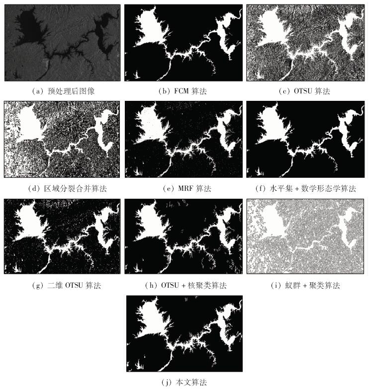
Abstract In this paper, a land and water segmentation algorithm based on hybrid fuzzy is proposed for the segmentation of SAR images. The algorithm is based on the gray features of SAR images, and dynamic multi threshold maximum between-class variance (OTSU) method is used for SAR image rough segmentation. The gray mean value of each homogeneous region is used as the initial clustering center of the fuzzy C mean algorithm so as to get the classification result by clustering iteration. Finally, the connected region method is used to remove the small pixels in the neighborhood, thus achieving fine segmentation of land and water. The experiments on GRDH data of Sentinel-1A show that the method has a relatively good segmentation effect for the SAR images of land objects and inland water areas with more tributaries.
|
| Keywords
land and water segmentation
multi threshold OTSU
fuzzy clustering
Danjiangkou Reservoir
|
|
|
|
Corresponding Authors:
Guolei SONG
E-mail: henusgl1992@qq.com
|
|
Issue Date: 07 December 2018
|
|
|
| [1] |
文江平, 胡岩峰, 王无敌 , 等. 一种有效的SAR图像水陆分割方法[J]. 四川兵工学报, 2010,31(2):108-110.
doi: 10.3969/j.issn.1006-0707.2010.02.035
url: http://www.cqvip.com/Main/Detail.aspx?id=33007024
|
| [1] |
Wen J P, Hu Y F, Wang W D , et al. An efficient method of land and water segmentation for SAR images[J]. Sichuan Ordnance Journal, 2010,31(2):108-110.
|
| [2] |
李璐 . 南水北调中线水源区多尺度生态环境综合评价[D]. 武汉:华中农业大学, 2010.
|
| [2] |
Li L . Integrative Assessment of Ecological Environment at Different Scale in Water Source Region of the Middle Route Project Under South-to-North Water Diversion[D]. Wuhan:Huazhong Agricultural University, 2010.
|
| [3] |
李景刚, 黄诗峰, 李纪人 . ENVISAT卫星先进合成孔径雷达数据水体提取研究——改进的最大类间方差阈值法[J]. 自然灾害学报, 2010,19(3):139-145.
|
| [3] |
Li J G, Huang S F, Li J R . Research on extraction of water body from ENVISAT ASAR images:A modified Otsu threshold method[J]. Journal of Natural Disasters, 2010,19(3):139-145.
|
| [4] |
安成锦, 牛照东, 李志军 , 等. 典型Otsu算法阈值比较及其SAR图像水域分割性能分析[J]. 电子与信息学报, 2010,32(9):2215-2219.
doi: 10.3724/SP.J.1146.2009.01426
url: http://d.wanfangdata.com.cn/Periodical/dzkxxk201009031
|
| [4] |
An C J, Niu Z D, Li Z J , et al. Otsu threshold comparison and SAR water segmentation result analysis[J]. Journal of Electronics and Information Technology, 2010,32(9):2215-2219.
|
| [5] |
安成锦, 陈曾平 . 基于Otsu和改进CV模型的SAR图像水域分割算法[J]. 信号处理, 2011,27(2):221-225.
doi: 10.3969/j.issn.1003-0530.2011.02.010
url: http://www.cqvip.com/Main/Detail.aspx?id=36934176
|
| [5] |
An C J, Chen Z P . SAR water segmentation based on Otsu and improved CV model[J]. Signal Processing, 2011,27(2):221-225.
|
| [6] |
尹奎英, 刘宏伟, 金林 . 快速的Otsu双阈值SAR图像分割法[J]. 吉林大学学报(工学版), 2011,41(6):1760-1765.
url: http://d.wanfangdata.com.cn/Periodical/jlgydxzrkxxb201106046
|
| [6] |
Yin K Y, Liu H W, Jin L . Fast SAR image segmentation method based on Otsu adaptive double threshold[J]. Journal of Jilin University(Engineering and Technology Edition), 2011,41(6):1760-1765.
|
| [7] |
赵向文, 靳国旺, 许竞轩 , 等. 基于多阈值大津法直方图分割的SAR数据伪彩色量化方法[J]. 测绘科学技术学报, 2012,29(6):445-449.
|
| [7] |
Zhao X W, Jin G W, Xu J X , et al. Pseudo-color quantization of SAR data based on multi-threshold Otsu method of histogram segmentation[J]. Journal of Geomatics Science and Technology, 2012,29(6):445-449.
|
| [8] |
杨旭 . 遥感影像的自适应阈值法水陆分割研究[J]. 科技资讯, 2013,11(5):42-43.
doi: 10.3969/j.issn.1672-3791.2013.05.031
url: http://www.cnki.com.cn/Article/CJFDTotal-ZXLJ201305030.htm
|
| [8] |
Yang X . Adaptive threshold method for land water segmentation based on remote sensing images[J]. Science and Technology Information, 2013,11(5):42-43.
|
| [9] |
曹亮 . 基于Otsu理论的图像分割算法研究[D]. 武汉:武汉理工大学, 2008.
|
| [9] |
Cao L . The Study of Image Segmentation Algorithm Based on Otsu Method[D]. Wuhan:Wuhan University of Technology, 2008.
|
| [10] |
Lee J S, Jurkevich I . Coastline detection and tracing in SAR images[J]. IEEE Transactions on Geoscience and Remote Sensing, 1990,28(4):662-668.
doi: 10.1109/TGRS.1990.572976
url: http://ieeexplore.ieee.org/document/572976/
|
| [11] |
Niedermeier A, Romaneessen E, Lehner S . Detection of coastlines in SAR images using wavelet methods[J]. IEEE Transactions on Geoscience and Remote Sensing, 2000,38(5):2270-2281.
doi: 10.1109/36.868884
url: http://ieeexplore.ieee.org/document/868884/
|
| [12] |
Rocca M R D, Fiani M, Fortunato A, et al. Active contour model to detect linear features in satellite images [C]//The International Archives of the Photogrammetry,Remote Sensing and Spatial Information Sciences. 2004,35(3):446-450.
|
| [13] |
Erteza I A . An Automatic Coastline Detector for Use with SAR Images[R]. United States:Sandia Report, 1998.
|
| [14] |
Sternberg S R . Grayscale morphology[J]. Computer Vision Graphics and Image Processing, 1986,35(3):333-355.
doi: 10.1016/0734-189X(86)90004-6
url: http://linkinghub.elsevier.com/retrieve/pii/0734189X86900046
|
| [15] |
倪维平, 严卫东, 边辉 , 等. 基于MRF模型和形态学运算的SAR图像分割[J]. 电光与控制, 2011,18(1):32-36.
url: http://www.opticsjournal.net/Articles/Abstract?aid=OJ110126000024UrXu1w
|
| [15] |
Ni W P, Yan W D, Bian H , et al. SAR image segmentation based on MRF model and morphological operation[J]. Electronics Optics and Control, 2011,18(1):32-36.
|
| [16] |
叶海军 . 基于纹理特征和数学形态学的SAR图像目标检测方法[J]. 中国电子科学研究院学报, 2009,4(4):436-440.
|
| [16] |
Ye H J . SAR image target detection method based on texture feature and mathematical morphology[J]. Journal of China Academy of Elecronics and Information Technology, 2009,4(4):436-440.
|
| [17] |
安健, 张扬 . 基于Otsu和模糊核聚类算法的极化SAR图像分类[J]. 电子科技, 2014,27(2):42-45.
doi: 10.3969/j.issn.1007-7820.2014.02.013
url: http://www.cqvip.com/QK/97319X/201402/48337785.html
|
| [17] |
An J, Zhang Y . Classification of polarimetric synthetic aperture Radar images based on Otsu’s method and fuzzy kernel C-means clustering algorithm[J]. Electronic Science and Technology, 2014,27(2):42-45.
|
| [18] |
毛万峰, 张红, 张波 , 等. 基于模糊水平集的SAR图像分割方法[J]. 中国科学院大学学报, 2013,30(2):238-243.
|
| [18] |
Mao W F, Zhang H, Zhang B , et al. A new fuzzy level set method for SAR image segmentation[J]. Journal of Graduate University of Chinese Academy of Sciences, 2013,30(2):238-243.
|
| [19] |
朱逸婷 . 基于改进的模糊聚类的分水岭分割算法研究[D]合肥: 安徽大学, 2013.
|
| [19] |
Zhu Y T . On Watershed Segmentation Algorithm Based on Improved Fuzzy Clustering[D]. Hefei:Anhui University, 2013.
|
| [20] |
SENTINEL TEAM.Sentinel-1 SAR user guide introduction[EB/ OL].( 2013-09-01) [2014-10-04].
url: https://sentinel.esa.int/web/sentinel/user-guides/sentinel-1-sar.
|
| [21] |
Lee J S, Jurkevich L, Dewaele P , et al. Speckle filtering of synthetic aperture Radar images:A review[J], Remote Sensing Reviews, 1994,8(4):313-340.
doi: 10.1080/02757259409532206
url: http://www.tandfonline.com/doi/abs/10.1080/02757259409532206
|
| [22] |
鲍义东, 周改云, 赵伟艇 . 自适应蚁群和模糊聚类的SAR图像分割[J]. 测绘科学, 2016,41(8):121-124,120.
|
| [22] |
Bao Y D, Zhou G Y, Zhao W T . Segmentation of SAR images based on adaptive ant colony algorithm and fuzzy C-means[J]. Science of Surveying and Mapping. 2016,41(8):121-124,120.
|
| [23] |
苏磊磊 . 基于小区域的图像显著度提取及应用研究[D]. 济南:山东师范大学, 2015.
|
| [23] |
Su L L . Image Salienvy Extraction and Application Based on Small Regions[D]. Jinan:Shandong Normal University, 2015.
|
| [24] |
郝智慧, 郭满才, 宋扬扬 . 结合全局与局部信息活动轮廓的非同质图像分割[J]. 中国图象图形学报, 2016,( 7):886-892.
doi: 10.11834/jig.20160706
url: http://d.wanfangdata.com.cn/Periodical/zgtxtxxb-a201607006
|
| [24] |
Hao Z H, Guo M C, Song Y Y . Inhomogeneous image segmentation based on active contours with global and local information[J]. Journal of Image and Graphics, 2016,( 7):886-892.
|
|
Viewed |
|
|
|
Full text
|
|
|
|
|
Abstract
|
|
|
|
|
Cited |
|
|
|
|
| |
Shared |
|
|
|
|
| |
Discussed |
|
|
|
|
 2018,
Vol. 30
2018,
Vol. 30
 )
)