|
|
 |
|

|
|
|
The evaluation of latest GPM-Era precipitation data in Yellow River Basin |
Yuanyuan LI1,2, Shaowei NING2( ), Wei DING1, Juliang JIN2, Zheng ZHANG1 ), Wei DING1, Juliang JIN2, Zheng ZHANG1 |
1.School of Hydraulic Engineering Dalian University of Technology, Dalian 116023, China
2.School of Civil Engineering, Hefei University of Technology, Hefei 230009, China |
|
|
|
|
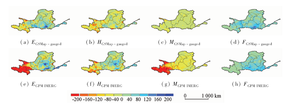
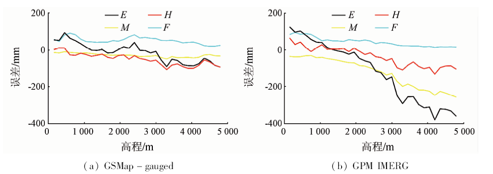
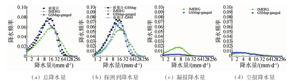
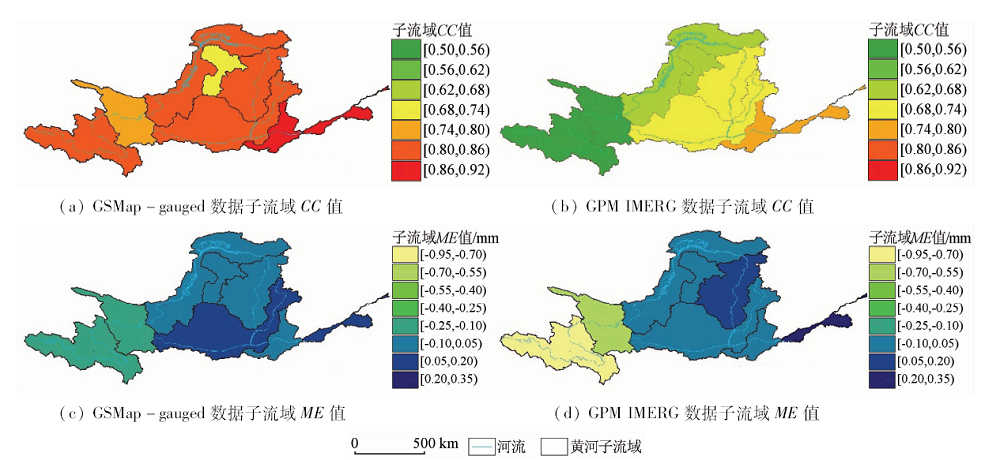
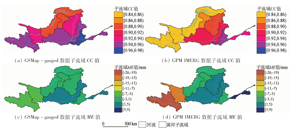
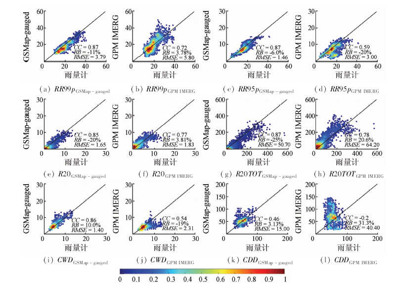
Abstract Based on the data from the rain gauge stations of the Yellow River Basin and using the evaluation index, extreme precipitation index and error analysis method, the authors studied the spatial and temporal variation characteristics of errors and the accuracy of data of two GPM satellite precipitation products (GSMap-gauged and GPM IMERG) obtained from April 2014 to March 2016 and analyzed the extreme precipitation capturing capability of the two products. The results showed that the two products generally underestimated precipitation in the western region of the basin and overestimated precipitation in the eastern part. Compared with GSMap-gauged, IMERG had bigger errors in most areas. In addition, the phenomenon of missing error in IMERG was more obvious due to elevation and precipitation intensity, but IMERG had a more accurate data for micro-precipitation. The daily scale data statistics showed that GSMap-gauged had a better relevance in each sub-basin, and its mean error is smaller. The correlation coefficient value of extreme precipitation index obtained by GSMap-gauged was higher than that of IMERG.
|
| Keywords
satellite precipitation products
gauge
error
|
|
|
|
Corresponding Authors:
Shaowei NING
E-mail: ning@hfut.edu.cn
|
|
Issue Date: 14 March 2019
|
|
|
| [1] |
Tang G Q, Ma Y Z, Long D , et al. Evaluation of GPM Day-1 IMERG and TMPA Version-7 legacy products over Mainland China at multiple spatiotemporal scales[J]. Journal of Hydrology, 2016,533:152-167.
doi: 10.1016/j.jhydrol.2015.12.008
url: https://linkinghub.elsevier.com/retrieve/pii/S0022169415009476
|
| [2] |
Buarque D C, De Paiva R C D, Clarke R T . A comparison of Amazon rainfall characteristics derived from TRMM,CMORPH and the Brazilian national rain gauge network[J]. Journal of Geophysical Research Atmospheres, 2011,116:D19.
doi: 10.1029/2011JD016060
url: http://onlinelibrary.wiley.com/doi/10.1029/2011JD016060/pdf
|
| [3] |
Germann U, Galli G, Boscacci M , et al. Radar precipitation measurement in a mountainous region[J]. Quarterly Journal of the Royal Meteorological Society, 2006,132(618):1669-1692.
doi: 10.1256/qj.05.190
url: http://doi.wiley.com/10.1256/qj.05.190
|
| [4] |
Dinku T, Anagnostou E N, Borga M . Improving Radar-based estimation of rainfall over complex terrain.[J]. Journal of Applied Meteorology, 2007,41(12):1163-1178.
doi: 10.1175/1520-0450(2002)0412.0.CO;2
url: http://adsabs.harvard.edu/abs/2002JApMe..41.1163D
|
| [5] |
嵇涛, 杨华, 刘睿 , 等. TRMM卫星降水数据在川渝地区的适用性分析[J]. 地理科学进展, 2014,33(10):1375-1386.
doi: 10.11820/dlkxjz.2014.10.009
url: http://d.wanfangdata.com.cn/Periodical/dlkxjz201410009
|
| [5] |
Ji T, Yang H, Liu R , et al. Applicability analysis of the TRMM precipitation data in the Sichuan-Chongqing region[J]. Progress in Geography, 2014,33(10):1375-1386.
|
| [6] |
Hong Y, Chen S, Xue X W , et al. Global precipitation estimation and applications[J]. Multiscale Hydrologic Remote Sensing, 2012: 371-386.
|
| [7] |
Hou A Y, Kakar R, Neeck S , et al. The global precipitation measurement mission[J]. Bulletin of the American Meteorological Society, 2014,95(5):701-722.
doi: 10.1175/bams-d-13-00164.1
url: http://journals.ametsoc.org/doi/abs/10.1175/BAMS-D-13-00164.1
|
| [8] |
Ning S W, Wang J, Jin J L , et al. Assessment of the latest GPM-Era high-resolution satellite precipitation products by comparison with observation gauge data over the Chinese mainland[J]. Water, 2016,8(11):481-497.
doi: 10.3390/w8110481
url: http://www.mdpi.com/2073-4441/8/11/481
|
| [9] |
唐国强, 万玮, 曾子悦 , 等. 全球降水测量(GPM)计划及其最新进展综述[J]. 遥感技术与应用, 2015,30(4):607-615.
doi: 10.11873/j.issn.1004-0323.2015.4.0607
url: http://www.cnki.com.cn/Article/CJFDTotal-YGJS201504001.htm
|
| [9] |
Tang G Q, Wan W, Zeng Z Y , et al. An overview of the global precipitation measurement (GPM) mission and it's latest development[J]. Remote Sensing Technology and Application, 2015,30(4):607-615.
|
| [10] |
孙永军 . 黄河流域湿地遥感动态监测研究[D]. 北京:北京大学, 2008.
|
| [10] |
Sun Y J . Study of Remote Sensing Monitoring of Wetland Dynamic Change in Yellow River Drainage Area[D]. Beijing:Peking University, 2008.
|
| [11] |
Guo H, Chen S, Bao A M , et al. Early assessment of integrated multi-satellite retrievals for global precipitation measurement over China[J].Atmospheric Research, 2016, 176-177(1):121-133.
doi: 10.1016/j.atmosres.2016.02.020
url: https://linkinghub.elsevier.com/retrieve/pii/S0169809516300370
|
| [12] |
Shen Y, Xiong A Y . Validation and comparison of a new gauge-based precipitation analysis over mainland China[J]. International Journal of Climatology, 2015,36(1):252-265.
doi: 10.1002/joc.4341
url: http://onlinelibrary.wiley.com/doi/10.1002/joc.4341/pdf
|
| [13] |
Ning S W, Song F, Udmale P , et al. Error analysis and evaluation of the latest GSMap and IMERG precipitation product over eastern China[J]. Advances in Meteorology, 2017(11):1-16.
|
| [14] |
Ushio T, Sasashige K, Kubota T , et al. A Kalman filter approach to the global satellite mapping of precipitation (GSMaP) from combined passive microwave and infrared radiometric data[J]. Journal of the Meteorological Society of Japan, 2009,87A(3):137-151.
doi: 10.2151/jmsj.87A.137
url: http://joi.jlc.jst.go.jp/JST.JSTAGE/jmsj/87A.137?from=CrossRef
|
| [15] |
Xie P P, Yatagai A, Chen M Y , et al. A Gauge-based analysis of daily precipitation over East Asia[J]. Journal of Hydrometeorology, 2007,8(3):607-626.
doi: 10.1175/JHM583.1
url: http://journals.ametsoc.org/doi/abs/10.1175/JHM583.1
|
| [16] |
Tian Y D , Peters-Lidard C D, Eylander J B, et al. Component analysis of errors in satellite-basd precipitation estimates[J]. Journal of Geophysical Research Atmospheres, 2009,114(2):137-144.
doi: 10.1029/2009JD011949
url: http://onlinelibrary.wiley.com/doi/10.1029/2009JD011949/full
|
|
Viewed |
|
|
|
Full text
|
|
|
|
|
Abstract
|
|
|
|
|
Cited |
|
|
|
|
| |
Shared |
|
|
|
|
| |
Discussed |
|
|
|
|
 2019,
Vol. 31
2019,
Vol. 31