|
|
 |
|

|
|
|
Precision validation of multi-sources land cover products derived from remote sensing |
Hongli SONG1,2, Xiaonan ZHANG3( ) ) |
1. School of Earth Science and Engineering, Hebei University of Engineering, Handan 056038, China
2. Heibei Collaborative Innovation Center of the Comprehensive Development and Utilization of Coal Resource, Handan 056038, China
3. School of mining and surveying engineering, Hebei University of Engineering, Handan 056038, China |
|
|
|
|
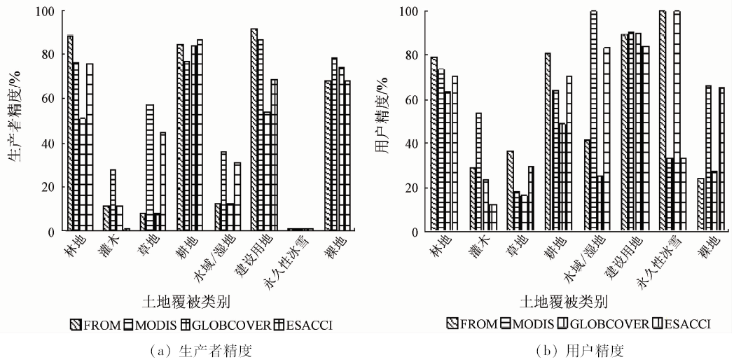
Abstract Global land cover maps (GLC) are essential input data for many scientific studies, so assessment of their category accuracy and category confusion is very important for some specific applications. In this paper, the authors chose China as the study region and FROM, MODIS, GLOBCOVER and ESACCI as land cover data for validation. The authors first aggregated the four GLC and referenced data provided by some international organizations into eight categories, and then validated four products through the category consistency and confusion matrix in national scale. The relative comparison between FROM, MODIS, ESACCI and GLOBCOVER shows that the four land cover products have the similar category constituent. Forest, grassland, cropland and bare land are the major land cover categories, whereas shrub, build up and water/wetland are relatively rare. Through comparing one by one between referenced data and land cover products, the authors constructed the confusion matrix, and the validated results demonstrate that FROM and MODIS have the best overall agreement with referenced data at national scale; for example, FROM’s overall accuracy is 0.69, and MODIS is 0.67, and ESACCI’s overall value is 0.65. Conversely, GLOBCOVER has the worst overall accuracy, with the value being only 0.55. Forest, cropland, built up land and bare land all have the better category accuracy, so each of them would be as input data for national forest inventory, food security and urban expansion, but shrub's category accuracy is low in four global land cover products, with confusion mainly occurring with forest, grass and cropland . The study results not only provide some scientific reference for selecting the input data for ecological environment modeling, land cover change analysis, natural resource survey, but also provide a reasonable advice for the research direction in future land cover mapping projects.
|
| Keywords
national scale
land cover products
category confusion
error matrix
accuracy evaluation
|
|
|
|
Corresponding Authors:
Xiaonan ZHANG
E-mail: 360217051@qq.com
|
|
Issue Date: 10 September 2018
|
|
|
| [1] |
廖安平, 陈利军, 陈军 , 等. 全球陆表水体高分辨率遥感制图[J]. 中国科学(地球科学), 2014,44(8):1634-1645.
|
| [1] |
Liao A P, Chen L J, Chen J , et al. High-resolution remote sensing mapping of global land water[J]. Science China(Earth Sciences), 2014,57(10):2305-2316.
|
| [2] |
陈军, 陈晋, 宫鹏 , 等. 全球地表覆盖高分辨率遥感制图[J]. 地理信息世界, 2011,9(2):12-14.
doi: 10.3969/j.issn.1672-1586.2011.02.002
url: http://d.wanfangdata.com.cn/Periodical/dlxxsj201102002
|
| [2] |
Chen J, Chen J, Gong P , et al. Higher resolution global land cover mapping[J]. Geomatics World, 2011,9(2):12-14.
|
| [3] |
LaFontaine J H, Hay L E, Viger R J , et al. Effects of climate and land cover on hydrology in the southeastern U.S.:Potential impacts on watershed planning[J]. Journal of the American Water Resources Association, 2015,51(5):1235-1261
doi: 10.1111/1752-1688.12304
url: http://doi.wiley.com/10.1111/1752-1688.12304
|
| [4] |
Gagné S A, Eigenbrod F, Bert D G , et al. A simple landscape design framework for biodiversity conservation[J]. Landscape and Urban Planning, 2015,136:13-27.
doi: 10.1016/j.landurbplan.2014.11.006
url: http://linkinghub.elsevier.com/retrieve/pii/S0169204614002667
|
| [5] |
Mantyka-Pringle C S, Visconti P, Di Marco M , et al. Climate change modifies risk of global biodiversity loss due to land-cover change[J]. Biological Conservation, 2015,187:103-111.
doi: 10.1016/j.biocon.2015.04.016
url: http://linkinghub.elsevier.com/retrieve/pii/S0006320715001615
|
| [6] |
Gessesse B, Bewket W, Bräuning A . Model‐based characterization and monitoring of runoff and soil erosion in response to land use/land cover changes in the Modjo watershed,Ethiopia[J]. Land Degradation & Development, 2015,26(7):711-724.
|
| [7] |
Loveland T R, Reed B C, Brown J F , et al. Development of a global land cover characteristics database and IGBP DISCover from 1 km AVHRR data[J]. International Journal of Remote Sensing, 2000,21(6/7):1303-1330.
doi: 10.1080/014311600210191
url: http://www.tandfonline.com/doi/abs/10.1080/014311600210191
|
| [8] |
Friedl M A , McIver D K,Hodges J C F,et al.Global land cover mapping from MODIS:Algorithms and early results[J]. Remote Sensing of Environment, 2002,83(1/2):287-302.
doi: 10.1016/S0034-4257(02)00078-0
url: http://linkinghub.elsevier.com/retrieve/pii/S0034425702000780
|
| [9] |
Hansen M C, Defries R S , Townshend J R G,et al.Global land cover classification at 1 km spatial resolution using a classification tree approach[J]. International Journal of Remote Sensing, 2000,21(6/7):1331-1364.
doi: 10.1080/014311600210209
url: http://www.tandfonline.com/doi/abs/10.1080/014311600210209
|
| [10] |
Bartholomé E, Belward A S . GLC2000:A new approach to global land cover mapping from Earth observation data[J]. International Journal of Remote Sensing, 2006,26(9):1959-1977.
doi: 10.1080/01431160412331291297
url: http://www.tandfonline.com/doi/full/10.1080/01431160412331291297
|
| [11] |
Chen J, Chen J, Liao A P , et al. Global land cover mapping at 30 m resolution:A POK-based operational approach[J]. ISPRS Journal of Photogrammetry and Remote Sensing, 2015,103:7-27.
doi: 10.1016/j.isprsjprs.2014.09.002
url: http://linkinghub.elsevier.com/retrieve/pii/S0924271614002275
|
| [12] |
Yu L, Wang J, Gong P . Improving 30 m global land-cover map FROM-GLC with time series MODIS and auxiliary data sets:A segmentation-based approach[J]. International Journal of Remote Sensing, 2013,34(16):5851-5867.
doi: 10.1080/01431161.2013.798055
url: http://www.tandfonline.com/doi/abs/10.1080/01431161.2013.798055
|
| [13] |
Arino O, Bicheron P, Achard F , et al. GlobCover:The most detailed portrait of Earth[J]. European Space Agency Bulletin, 2008,136:24-31.
url: http://www.researchgate.net/publication/280017262_GLOBCOVER_the_most_detailed_portrait_of_Earth
|
| [14] |
Tsendbazar N E, De Bruin S, Fritz S , et al. Spatial accuracy assessment and integration of global land cover datasets[J]. Remote Sensing, 2015,7(12):15804-15821.
doi: 10.3390/rs71215804
url: http://www.mdpi.com/2072-4292/7/12/15804
|
| [15] |
Defourny P, Mayaux P, Herold M , et al. Global land-cover map validation experiences:Toward the characterization of quantitative uncertainty[M] //Chandra P G.Remote Sensing of Land Use and Land Cover: Principles and Applications.Engelska:CRC Press, 2012.
|
| [16] |
Friedl M A, Sulla-Menashe D, Tan B , et al. MODIS Collection 5 global land cover:Algorithm refinements and characterization of new datasets[J]. Remote Sensing of Environment, 2010,114(1):168-182.
doi: 10.1016/j.rse.2009.08.016
url: http://linkinghub.elsevier.com/retrieve/pii/S0034425709002673
|
| [17] |
Olofsson P, Stehman S V, Woodcock C E , et al. A global land-cover validation data set,part I:Fundamental design principles[J]. International Journal of Remote Sensing, 2012,33(18):5768-5788.
doi: 10.1080/01431161.2012.674230
url: http://www.tandfonline.com/doi/abs/10.1080/01431161.2012.674230
|
| [18] |
Fritz S, McCallum I ,Schill C ,et al.Geo-Wiki.Org:The use of crowdsourcing to improve global land cover[J]. Remote Sensing, 2009,1(3):345-354.
doi: 10.3390/rs1030345
url: http://www.mdpi.com/2072-4292/1/3/345
|
| [19] |
Tateishi R, Uriyangqai B, Al-Bilbisi H , et al. Production of global land cover data-GLCNMO[J]. International Journal of Digital Earth, 2011,4(1):22-49.
doi: 10.1080/17538941003777521
url: http://www.tandfonline.com/doi/abs/10.1080/17538941003777521
|
| [20] |
陆苗, 吴文斌, 张莉 , 等. 不同耕地数据集在中国区域的对比研究[J]. 中国科学(地球科学), 2016,46(11):1459-1471.
|
| [20] |
Lu M, Wu W B, Zhang L , et al. A comparative analysis of five global cropland datasets in China[J]. Science China(Earth Sciences), 2016,59(12):2307-2317
|
| [21] |
Congalton R . G.A review of assessing the accuracy of classifications of remotely sensed data[J]. Remote Sensing of Environment, 1991,37(1):35-46.
doi: 10.1046/j.1365-2249.2000.01137.x
url: http://linkinghub.elsevier.com/retrieve/pii/003442579190048B
|
|
Viewed |
|
|
|
Full text
|
|
|
|
|
Abstract
|
|
|
|
|
Cited |
|
|
|
|
| |
Shared |
|
|
|
|
| |
Discussed |
|
|
|
|
 2018,
Vol. 30
2018,
Vol. 30