|
|
 |
|

|
|
|
Integrating visual features in polarimetric SAR image classification |
| Pengyan HUANG1, Lijing BU2, Yongliang FAN3 |
1. School of Civil Engineering, Luoyang Institute of Science and Technology, Luoyang 471000, China
2. School of Mapping and Geographical Science, Liaoning Technical University, Fuxin 123000,China
3. College of Civil Engineering and Mechanics, Lanzhou University, Lanzhou 730000, China |
|
|
|
|
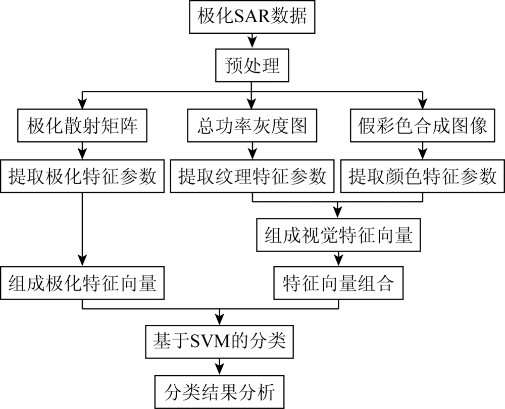
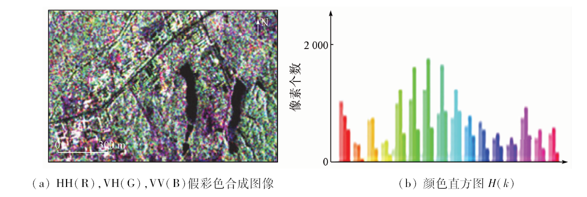
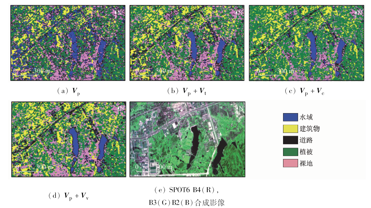
Abstract In order to improve the polarimetric synthetic aperture Radar (SAR) images classification accuracy by fully extracting variety of useful information, this paper proposes integrating visual features in SAR images classification. Firstly the authors constructed the polarimetric decomposition feature vector, then extracted texture parameters with Grayscale symbiosis matrix, and finally extracted color feature parameters by pseudo-color image. Based on constructing visual vector with texture and color parameter, the authors integrated the visual vector with the polarimetric feature vector to combine the new feature vectors. Using different feature vectors for classification of full PolSAR image, the authors made a comparative study of the classification results. The results show that the combination of visual features can effectively improve the classification accuracy of fully polarimetric SAR image.
|
| Keywords
target decomposition
visual features
polarimetric SAR image classification
feature vector
|
|
|
|
Issue Date: 18 June 2020
|
|
|
| [1] |
Thompson B J, Lee J S, Pottier E. Polarimetric radar imaging:From basics to applications[M]. Boca Raton: CRC Press, 2009: 13-22.
|
| [2] |
吴一戎, 洪文, 王彦平. 极化干涉SAR的研究现状与启示[J]. 电子与信息学报, 2007,29(5):1258-1262.
|
| [2] |
Wu Y R, Hong W, Wang Y P. The current status and implications of polarimetric SAR interferometry[J]. Journal of Electronics and Information Technology, 2007,29(5):1258-1262.
|
| [3] |
Yang J C, Yu K, Gong Y H, et al. Linear spatial pyramid matching using sparse coding for image classification [C]// Proceedings of the IEEE Computer Society Conference on Computer Vision and Pattern Recognition.Miami:IEEE, 2009,2(5):1794-1801.
|
| [4] |
Ersahin K, Cumming I G, Ward R K. Segmentation and classification of polarimetric SAR data using spectral graph partitioning [C]// 2007 IEEE International Geoscience and Remote Sensing Symposium. Barcelona:IEEE, 2007.
|
| [5] |
韩景红, 王海江. 基于MV与Wishart距离的极化SAR图像分类[J]. 成都信息工程大学学报, 2019,34(1):31-34.
|
| [5] |
Han J H, Wang H J. PolSAR image classification based on MV and Wishart distance[J]. Journal of Chengdu University of Information Technology, 2019,34(1):31-34.
|
| [6] |
张佳琪, 张继贤, 赵争. 深度神经网络的高分三号全极化SAR图像分类方法[J]. 测绘科学, 2019,44(2):6-11.
|
| [6] |
Zhang J Q, Zhang J X, Zhao Z. Classification method of GF-3 polarimetric SAR image using deepneural network[J]. Science of Surveying and Mapping, 2019,44(2):6-11.
|
| [7] |
杨玉锋. 基于目标分解的全极化SAR图像分类方法研究[D]. 南京:南京林业大学, 2016.
|
| [7] |
Yang Y F. Classification method of polarimetric SAR image based on target decomposition[D]. Nanjing:Nanjing Forestry University, 2016.
|
| [8] |
韩飞. 基于目标分解的极化合成孔径雷达图像分类研究[D]. 成都:电子科技大学, 2016.
|
| [8] |
Han F. Classification method of polarimetric SAR image based on target decomposition[D]. Chengdu:University of Electronic Science and Technology of China, 2016.
|
| [9] |
Du L J, Lee J S. Polarimetric SAR image classification based on target decomposition theorem and complex Wishart distribution[J]. 1996 International Geoscience and Remote Sensing Symposium.IEEE, 1996,1(5):439-441.
|
| [10] |
赵泉华, 郭世波, 李晓丽, 等. 利用目标分解特征的全极化SAR海冰分类[J]. 测绘学报, 2018,47(12):1609-1620.
|
| [10] |
Zhao Q H, Guo S B, Li X L, et al. Polarimetric SAR sea ice classification based on target decompositional features[J]. Acta Geodaetica et Cartographica sinica, 2018,47(12):1609-1620.
|
| [11] |
于昕梅, 朱林. 图像视觉特征综述[J].广东通信技术, 2004(s1):108-109,121.
|
| [11] |
Yu X M, Zhu L. Overview of image visual features[J].Guangdong Communication Technology, 2004(s1):108-109,121.
|
| [12] |
Zhang L M, Zou B, Zhang J P, et al. Classification of polarimetric SAR image based on support vector machine using multiple-component scattering model and texture features [C]// 2009 2nd Asian-Pacific Conference on Synthetic Aperture Radar.IEEE, 2009.
|
| [13] |
Dell’ Acqua F, Gamba P. Texture-based characterization of urban environments on satellite SAR images[J]. IEEE Transactions on Geoscience and Remote sensing, 2003,41(1):153-159.
|
| [14] |
Kandaswamy U, Adjeroh D A, Lee M. Efficient texture analysis of SAR imagery[J]. IEEE Transaction on Geoscience and Remote sensing, 2005,43(9):2075-2083.
|
| [15] |
Uhlmann S, Kiranyaz S. Integrating color features in polarimetric SAR image classification[J]. IEEE Transaction on Geoscience and Remote sensing, 2014,52(4):2197-2216.
doi: 10.1109/TGRS.36
url: https://ieeexplore.ieee.org/xpl/RecentIssue.jsp?punumber=36
|
| [16] |
卜丽静, 黄鹏艳, 沈璐. 一种结合颜色特征的PolSAR图像分类方法[J]. 国土资源遥感, 2017,29(3):59-64.doi: 10.6046/gtzyyg.2017.03.08.
|
| [16] |
Bu L J, Huang P Y, Shen L. Integrating color features in polarimetric SAR image classification[J]. Remote Sensing for Land and Resources, 2017,29(3):59-64.doi: 10.6046/gtzyyg.2017.03.08.
|
| [17] |
Chang C C, Lin C J. LIBSVM:A library for support vector machines[J]. ACM Transactions on Intelligent Systems and Technology, 2011,2(3):1-27.
|
| [18] |
Ersahin K, Scheuchl B, Cumming I. Incorporating texture information into polarimetric radar classification using neural networks [C]// Proceedings of 2004 IEEE International.Geoscience and Remote Sensing Symposium.New York:IEEE, 2004: 560-563.
|
| [19] |
胡召玲, 李海权, 杜培军. SAR图像纹理特征提取与分类研究[J]. 中国矿业大学学报, 2009,38(3):422-427.
|
| [19] |
Hu Z L, Li H Q, Du P J. Study on the extraction of texture features andiIts application in classifying SAR images[J]. Journal of China University o f Mining and Technology, 2009,38(3):422-427.
|
| [20] |
李林科. 基于深度学习的视觉内容描述技术研究[D]. 成都:电子科技大学, 2018.
|
| [20] |
Li L K. Research on visual content description technology based on deep learning[D]. Chengdu:University of Electronic Science and Technology of China, 2018.
|
| [21] |
Huynen J R. Phenomenological theory of Radar targets[D]. Delft:Delft Technical University, 1970.
|
| [22] |
Freeman A, Durden S. A three-component scattering model for polarimetric SAR data[J]. IEEE Transaction on Geoscience and Remote Sensing, 1998,36(3):963-973.
|
| [23] |
肖鹏峰, 刘顺喜, 冯学智, 等. 中分辨率遥感图像土地利用与覆被分类的方法及精度评价[J]. 国土资源遥感, 2004,16(4):41-45,79.doi: 10.6046/gtzyyg.2004.04.11.
|
| [23] |
Xiao P F, Liu S X, Feng X Z, et al. Methods and accuracy assessment for land use and cover classificationbased on medium resolution remotely sensed data[J]. Remote Sensing for Land and Resources, 2004,16(4):41-45,79.doi: 10.6046/gtzyyg.2004.04.11.
|
| [24] |
叶润青, 牛瑞卿, 张良培, 等. 基于图像分类的矿物含量测定及精度评价[J]. 中国矿业大学学报, 2011,40(5):810-815,822.
|
| [24] |
Ye R Q, Niu R Q, Zhang L P, et al. Mineral contents determination and accuracy evaluation based on classification of petrographic images[J]. Journal of China University of Mining and Technology, 2011,40(5):810-815,822.
|
|
Viewed |
|
|
|
Full text
|
|
|
|
|
Abstract
|
|
|
|
|
Cited |
|
|
|
|
| |
Shared |
|
|
|
|
| |
Discussed |
|
|
|
|
 2020,
Vol. 32
2020,
Vol. 32