|
|
 |
|

|
|
|
Karayaylak glacier changes in the Kongur Mountain of eastern Pamir between 1973 and 2016 based on active and passive remote sensing technologies |
Lili FENG1,2, Liming JIANG1,2( ), Lin LIU3, Yafei SUN4 ), Lin LIU3, Yafei SUN4 |
1. State Key Laboratory of Geodesy and Earth’s Dynamics, Innovation Academy for Precision Measurement Science and Technology, CAS, Wuhan 430071, China
2. University of Chinese Academy of Sciences, Beijing 100049,China
3. MOE Key Laboratory of Fundamental Physical Quantities Measurement, School of Physics, Huazhong University of Science and Technology, Wuhan 430074, China
4. Henan University of Urban Construction, Pingdingshan 467036, China |
|
|
|
|
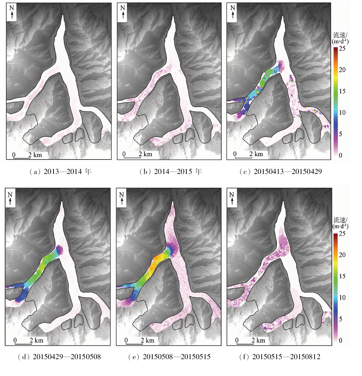
Abstract Located on the northern slope of Kongur Mountains, Karayaylak glacier surged in May 2015. For the purpose of obtaining the glacier surface elevation changes of the Karayaylak glacier from 1973 to 2016, the authors used the 1973 Keyhole satellite optical remote sensing data, the US SRTM DEM data in 2000, and the TanDEM-X bistatic SAR data in 2013 and 2016. The results show that, from 1973 to 2013, there was no obvious elevation change; from 2013 to 2016, clear surface thickening was observed at the terminus of the west branch, whereas a relatively obvious glacial surface elevation thinning was detected in the upper part of the glacier. Landsat OLI image from 2013 to 2015 were employed to monitor the change of glacier surface velocities. The distributions and changes of the glacier surface velocities indicate that the western tributary of Karayaylak glacier moved faster than any other tributaries. According to the comprehensive analysis, it is considered that there is no obvious advance or retreat trend at the terminus of the glacier before glacier surge, and the flow velocity of the glacier has changed greatly. In addition, combined with the results of meteorological data, it is believed that the glacial surge has little to do with local climate change. The main reason for the surge is probably attributed to the structural change of the glacier itself.
|
| Keywords
Karayaylak glacier
glacier surge
active and passive remote sensing
glacier elevation change
glacier flow velocity
|
|
|
|
Corresponding Authors:
Liming JIANG
E-mail: jlm@whigg.ac.cn
|
|
Issue Date: 18 June 2020
|
|
|
| [1] |
Meier Mark F, Post Post Austin. What are glacier surges?[J]. Canadian Journal of Earth Sciences, 1969,6(4):807.
doi: 10.1139/e69-081
url: http://www.nrcresearchpress.com/doi/10.1139/e69-081
|
| [2] |
Kamb B, Raymond C F, Harrison W D, et al. Glacier surge mechanism:1982—1983 surge of variegated glacier,Alaska[J]. Science, 1985,227(4686):469-479.
doi: 10.1126/science.227.4686.469
url: https://www.sciencemag.org/lookup/doi/10.1126/science.227.4686.469
|
| [3] |
Luckman A.Karakoram glacier surge dynamics[J].Geophysical Research Letters, 2011, 38(18):n/a-n/a.
|
| [4] |
Citterio M, Paul F, Ahlstrøm A P, et al. Remote sensing of glacier change in West Greenland:Accounting for the occurrence of surge-type glaciers[J]. Annals of Glaciology, 2009,50(53):70-80.
doi: 10.3189/172756410790595813
url: https://www.cambridge.org/core/product/identifier/S0260305500252117/type/journal_article
|
| [5] |
Copland L, Sylvestre T, Bishop M P, et al. Expanded and recently increased glacier surging in the Karakoram[J]. Arctic Antarctic & Alpine Research, 2011,43(4):503-516.
|
| [6] |
Fischer A, Rott H, Björnsson H. Observation of recent surges of Vatnajökull,Iceland,by means of ERS SAR interferometry[J]. Annals of Glaciology, 2003,37(1):69-76.
|
| [7] |
Jiskoot H, Murray T, Luckman A. Surge potential and drainage-basin characteristics in East Greenland[J]. Annals of Glaciology, 2017,36(1):142-148.
|
| [8] |
Kotlyakov V M, Osipova G B, Tsvetkov D G. Monitoring surging glaciers of the Pamirs,central Asia,from space[J]. Annals of Glaciology, 2008,48(1):125-134.
|
| [9] |
Dowdeswell Julian A, Williams M. Surge-type glaciers in the Russian High Arctic identified from digital satellite imagery[J]. Journal of Glaciology, 1997,43(145):489-494.
doi: 10.1017/S0022143000035097
url: https://www.cambridge.org/core/product/identifier/S0022143000035097/type/journal_article
|
| [10] |
Kotlyakov V M, Rototaeva O V, Nosenko G A. The September 2002 Kolka glacier catastrophe in north Ossetia,Russian Federation:Evidence and analysis[J]. Mountain Research & Development, 2014,24(Feb 2004):78-83.
|
| [11] |
Sevestre Heïdi, Benn Douglas I. Climatic and geometric controls on the global distribution of surge-type glaciers:Implications for a unifying model of surging[J]. Journal of Glaciology, 2015,61(228):646-662.
|
| [12] |
上官冬辉, 刘时银, 丁永建, 等. 喀喇昆仑山克勒青河谷近年来发现有跃动冰川[J]. 冰川冻土, 2005,27(5):641-644.
|
| [12] |
Shangguan D H, Liu S Y, Ding Y J, et al. Surging glacier found in Shaksgam River,Karakorum Mountains[J]. Journal of Glacioligy and Geocryology, 2005,27(5):641-644.
|
| [13] |
郭万钦, 刘时银, 许君利, 等. 木孜塔格西北坡鱼鳞川冰川跃动遥感监测[J]. 冰川冻土, 2012,34(4):765-774.
|
| [13] |
Guo W Q, Liu S Y, Xu J L, et al. Monitoring recent surging of the Yulinchuan glacier on north slopes of Muztag range by remote sensing[J]. Journal of Glaciology and Geocryology, 2012,34(4):765-774.
|
| [14] |
刘景时, 王迪. 2009年夏季喀喇昆仑山叶尔羌河上游发生冰川跃动[J]. 冰川冻土, 2009,31(5):992.
|
| [14] |
Liu J S, Wang D. Glacier surge in the upper reaches of the Yarkant River in the Karakorum Mountains in 2009[J]. Journal of Glaciology and Geocrylolgy, 2009,31(5):992-992.
|
| [15] |
Kääb A, Leinss S, Gilbert A, et al. Massive collapse of two glaciers in western Tibet in 2016 after surge-like instability[J]. Nature Geoscience, 2018,11(2):1.
|
| [16] |
Farr T G, Rosen P A, Caro E, et al. The Shuttle Radar Topography Mission[J]. Reviews of Geophysics, 2007,45(2):361.
|
| [17] |
González J H, Antony J M W, Bachmann M,et al.Bistatic system and baseline calibration in TanDEM-X to ensure the global digital elevation model quality[J]. Isprs Journal of Photogrammetry & Remote Sensing, 2012,73(3):3-11.
|
| [18] |
Martone,Michele,Braitogam,et al.Coherence evaluation of TanDEM-X interferometric data[J]. Isprs Journal of Photogrammetry & Remote Sensing, 2012,73(6):21-29.
|
| [19] |
Gruber A, Wessel B, Huber M, et al. Operational TanDEM-X DEM calibration and first validation results[J]. Isprs Journal of Photogrammetry & Remote Sensing, 2012,73(6):39-49.
|
| [20] |
Rizzoli P, Bräutigam B, Kraus T, et al. Relative height error analysis of TanDEM-X elevation data[J]. Isprs Journal of Photogrammetry & Remote Sensing, 2012,73(6):30-38.
|
| [21] |
Rossi C, Fritz T, Eineder M, et al. Towards AN Urban DEM Generation with Satellite SAR Interferometry[R]. Isprs, 2012.
|
| [22] |
Bolch T, Pieczonka T, Mukherjee K, et al. Brief communication:Glaciers in the Hunza catchment(Karakoram) have been nearly in balance since the 1970s[J]. Cryosphere, 2017,11(531):531-539.
doi: 10.5194/tc-11-531-2017
url: https://www.the-cryosphere.net/11/531/2017/
|
| [23] |
Huber M, Wessel B, Kosmann D, et al. Ensuring globally the TanDEM-X height accuracy:Analysis of the reference data sets ICESat,SRTM and KGPS-tracks[C].Geoscience and Remote Sensing Symposium,2009 IEEE International,Igarss, 2009.
|
| [24] |
Gonzalez J H, Bachmann M, Scheiber R, et al. Definition of ICESat selection criteria for their use as height references for TanDEM-X[J]. IEEE Transactions on Geoscience & Remote Sensing, 2010,48(6):2750-2757.
|
| [25] |
Sun Y, Jiang L M, Liu L, et al. Mapping glacier elevations and their changes in the western Qilian Mountains,northern Tibetan Plateau, by Bistatic InSAR[J]. IEEE Journal of Selected Topics in Applied Earth Observations & Remote Sensing, 2017,(99):1-11.
|
| [26] |
Zhou Y S, Li Z W, Jia L. Slight glacier mass loss in the Karakoram region during the 1970s to 2000 revealed by KH-9 images and SRTM DEM[J]. Journal of Glaciology, 2017,63(238):331-342.
|
| [27] |
Leprince S, Barbot S, Ayoub F, et al. Automatic and precise orthorectification,coregistration,and subpixel correlation of satellite images,application to ground deformation measurements[J]. IEEE Transactions on Geoscience & Remote Sensing, 2007,45(6):1529-1558.
|
| [28] |
Bolch T, Pieczonka T, Benn D I. Multi-decadal mass loss of glaciers in the Everest area(Nepal Himalaya) derived from stereo imagery[J]. Cryosphere, 2011,5(2):349-358.
doi: 10.5194/tc-5-349-2011
url: https://www.the-cryosphere.net/5/349/2011/
|
| [29] |
Gardelle J, Berthier E, Arnaud Y, et al. Region-wide glacier mass balances over the Pamir-Karakoram-Himalaya during 1999—2011[J]. Cryosphere, 2013,7(6):1885-1886.
doi: 10.5194/tc-7-1885-2013
url: http://dx.doi.org/10.5194/tc-7-1885-2013
|
| [30] |
蒋宗立, 刘时银, 龙四春, 等. 基于合成孔径雷达技术及DEM的公格尔山冰川动力特征分析[J]. 冰川冻土, 2014,36(2):286-295.
doi: 10.7522/j.issn.1000-0240.2014.0035
url: http://bcdt.westgis.ac.cn/CN/abstract/abstract3396.shtml
|
| [30] |
Jiang Z L, Liu S Y, Long S C, et al. Analysis of the glacier dynamics features in Kongur Mountain based on SAR technology and DEMs[J]. Journal of Glaciology and Geocryology, 2014,36(2):286-295.
doi: 10.7522/j.issn.1000-0240.2014.0035
url: http://bcdt.westgis.ac.cn/CN/abstract/abstract3396.shtml
|
| [31] |
Quincey D J, Glasser N F, Cook S J, et al. Heterogeneity in Karakoram glacier surges[J]. Journal of Geophysical Research Earth Surface, 2015,120(7):1288-1300.
doi: 10.1002/2015JF003515
url: http://doi.wiley.com/10.1002/2015JF003515
|
| [32] |
Kamb B. Glacier surge mechanism based on linked cavity configuration of the basal water conduit system[J]. Journal of Geophysical Research:Solid Earth, 1987,92(B9):9083-9100.
|
| [33] |
Fowler C A. A theory of glacier surges[J]. Journal of Geophysical Research Solid Earth, 1987,92(B9):9111-9120.
|
| [34] |
Benn D I, Evans D J A.Glaciers and glaciation[J]. Hodder Education, 2010,29(3):869-875.
|
| [35] |
Clarke G K C, Collins S G, Thompson D E. Flow,thermal structure,and subglacial conditions of a surge-type glacier[J]. Canadian Journal of Earth Sciences, 1984,21(2):232-240.
doi: 10.1139/e84-024
url: http://www.nrcresearchpress.com/doi/10.1139/e84-024
|
| [36] |
Mayer C, Fowler A C, Lambrecht A, et al. A surge of North Gasherbrum Glacier, Karakoram,China[J].Journal of Glaciology, 2011, volume 57(205): 904-916(913).
url: WOS:000296118700014
|
| [37] |
Murray T, Stuart G W, Miller P J, et al. Glacier surge propagation by thermal evolution at the bed[J]. Journal of Geophysical Research Solid Earth, 2000,105(B6):13491-13507.
|
| [38] |
Chevalier M L. 青藏高原西部喀喇昆仑断裂活动构造研究进展综述(英文)[J]. 地球学报, 2019,40(1):37-54.
|
| [38] |
Chevalier M L. Active tectonics along the Karakorum fault,western Tibetan Plateau:A review[J]. Acta Geoscientia Sinica, 2019,40(1):37-54.
|
|
Viewed |
|
|
|
Full text
|
|
|
|
|
Abstract
|
|
|
|
|
Cited |
|
|
|
|
| |
Shared |
|
|
|
|
| |
Discussed |
|
|
|
|
 2020,
Vol. 32
2020,
Vol. 32