|
|
|
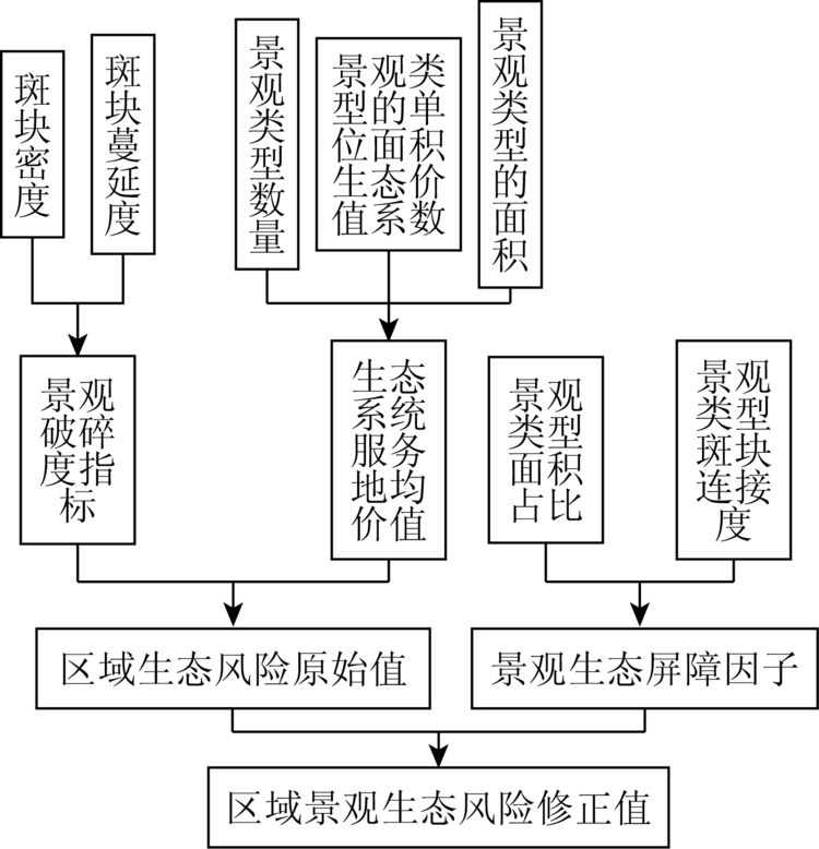
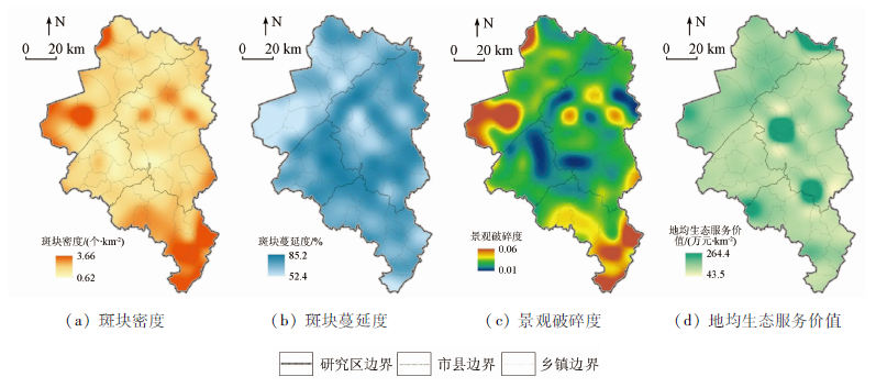
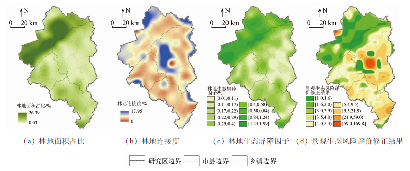
Abstract Carrying out territory virescence action and ecological barrier construction is one of the important measures of eco-civilization construction in China. At present, the ecological problems in the northwestern part of Changchun economic circle are relatively prominent, which have become the shortcoming of regional ecological security. Based on the ecological background characteristics and main ecological problems of the study area, the authors constructed a quantitative assessment method for landscape ecological risk including ecological barrier factor. The results are as follows: ① The key areas of ecological barrier construction in the study area include two categories: areas where landscape ecological risk is relatively high, and areas where ecological barrier construction is relatively weak; ② the areas with relatively high landscape ecological risk are mainly distributed in the central part of Nong’an County, accounting for 1.25% and 1.74% of the total area of the study area; ③ the relatively weak areas of ecological barrier construction are the areas where the landscape ecological risk increases after the introduction of ecological barrier factor, mainly distributed in the border zone between Changlin County and Nong’an County, accounting for about 1/4 of the total area. Based on the comprehensive problem-oriented and target-oriented approach, the authors put forward strategies from two aspects of strengthening the control of landscape ecological risk and promoting ecological construction in relatively weak areas, so as to promote the high-quality and sustainable development of Changchun economic circle. This study provides not only a feasible idea for the study of regional ecological barrier construction and related ecological planning but also a useful reference for the optimization of land space spatial pattern.
|
| Keywords
ecological barrier
landscape ecological risk assessment
ecological security
optimization of land space spatial pattern
Changchun economic circle
|
|
|
|
Issue Date: 23 December 2020
|
|
|
| [1] |
生态屏障、功能区划与人口发展课题组. 建设国家生态屏障,促进人口资源环境协调发展——关于内蒙古、甘肃等8省区人口资源环境问题的调研报告[J]. 人口研究, 2008,32(2):1-4.
|
| [1] |
Research group on ecological barrier,functional zoning and population development. Build national ecological barrier to promote coordinated development of population,resources and environment:Research report on problems of population,resources and environment in 8 provinces and regions including Inner Mongolia,Gansu,et al.[J]. Population Research, 2008,32(2):1-4.
|
| [2] |
王玉宽, 孙雪峰, 邓玉林, 等. 对生态屏障概念内涵与价值的认识[J]. 山地学报, 2005(7):431-436.
|
| [2] |
Wang Y K, Sun X F, Deng Y L, et al. Discussion on concept definition and academic value of ecological defence[J]. Journal of Mountain Science, 2005(7):431-436.
|
| [3] |
曹祺文, 张曦文, 马洪坤, 等. 景观生态风险研究进展及基于生态系统服务的评价框架:ESRISK[J]. 地理学报, 2018,73(5):843-855.
|
| [3] |
Cao Q W, Zhang X W, Ma H K, et al. Review of landscape ecological risk and an assessment framework based on ecological services:ESRISK[J]. Acta Geographica Sinica, 2018,73(5):843-855.
|
| [4] |
彭建, 党威雄, 刘焱序, 等. 景观生态风险评价研究进展与展望[J]. 地理学报, 2015,70(4):664-677.
|
| [4] |
Peng J, Dang W X, Liu Y X, et al. Review on landscape ecological risk assessment[J]. Acta Geographica Sinica, 2015,70(4):664-677.
|
| [5] |
周利军, 张雪萍, 陈设. 扎龙自然保护区土地利用变化与生态风险评价[J]. 自然灾害学报, 2009(2):186-190.
|
| [5] |
Zhou L J, Zhang X P, Chen S. Land use change and ecological risk assessment of Zhalong Natural Protection area[J]. Journal of Natural Disasters, 2009(2):186-190.
|
| [6] |
巩杰, 赵彩霞, 谢余初, 等. 基于景观格局的甘肃白龙江流域生态风险评价与管理[J]. 应用生态学报, 2014(7):2041-2048.
pmid: 25345056
|
| [6] |
Gong J, Zhao C X, Xie Y C, et al. Ecological risk assessment and its management of Bailongjiang watershed,southern Gansu based on landscape pattern[J]. Chinese Journal of Applied Ecology, 2014(7):2041-2048.
pmid: 25345056
url: https://www.ncbi.nlm.nih.gov/pubmed/25345056
|
| [7] |
张月, 张飞, 周梅, 等. 干旱区内陆艾比湖区域景观生态风险评价及时空分异[J]. 应用生态学报, 2016,27(1):233-242.
pmid: 27228614
|
| [7] |
Zhang Y, Zhang F, Zhou M, et al. Landscape ecological risk assessment and its spatio-temporal variations in Ebinur Lake region of inland arid area[J]. Chinese Journal of Applied Ecology, 2016,27(1):233-242.
pmid: 27228614
url: https://www.ncbi.nlm.nih.gov/pubmed/27228614
|
| [8] |
潘竟虎, 刘晓. 疏勒河流域景观生态风险评价与生态安全格局优化构建[J]. 生态学杂志, 2016,35(3):791-799.
|
| [8] |
Pan J H, Liu X. Landscape ecological risk assessment and landscape security pattern optimization in Shule River Basin[J]. Chinese Journal of Ecology, 2016,35(3):791-799.
|
| [9] |
李月月, 黄义雄, 杨阳, 等. 基于景观结构的福建省沿海生态风险时空特征[J]. 水土保持通报, 2018,38(4):241-246.
|
| [9] |
Li Y Y, Huang Y X, Yang Y, et al. Temporal and spatial characteristics of coastal ecological risk in the Fujian Province based on landscape structure[J]. Bulletin of Soil and Water Conservation, 2018,38(4):241-246.
|
| [10] |
奚世军, 安裕伦, 李阳兵, 等. 基于景观格局的喀斯特山区流域生态风险评估——以贵州省乌江流域为例[J]. 长江流域资源与环境, 2019,28(3):712-721.
|
| [10] |
Xi S J, An Y L, Li Y B, et al. Ecological risk assessment of Karst mountain watershed based on landscape pattern:A case study of Wujiang River Basin in Guizhou Province[J]. Resources and Environment in the Yangtze Basin, 2019,28(3):712-721.
|
| [11] |
李小燕, 柳书俊, 王志杰. 南水北调中线汉中市水源地景观生态风险评价与特征[J]. 水土保持研究, 2019,26(5):181-187.
|
| [11] |
Li X Y, Liu S J, Wang Z J. Landscape ecological risk characteristics of water source site in Hanzhong City of the middle route of the South-to-North water transfer project of China[J]. Research of Soil and Water Conservation, 2019,26(5):181-187.
|
| [12] |
孙贤斌, 刘红玉. 江苏盐城市海滨土地利用对景观生态风险的影响[J]. 国土资源遥感, 2011,23(3):140-145.doi: 10.6046/gtzyyg.2011.03.25.
doi: 10.6046/gtzyyg.2011.03.25
url: http://www.gtzyyg.com/CN/abstract/abstract1430.shtml
|
| [12] |
Sun X B, Liu H Y. The effect of land use on landscape ecological risk in Yancheng coastal area,Jiangsu Province[J]. Remote Sensing for Land and Resource, 2011,23(3):140-145.doi: 10.6046/gtzyyg.2011.03.25.
|
| [13] |
Yu Z L, Qin T L. The impact on the ecosystem services value of the ecological shelter zone reconstruction in the upper reaches basin of the Yangtze River in China[J]. International Journal of Environmental Research and Public Health, 2018(15):2273.
|
| [14] |
余凡. 土地利用总体规划中生态屏障用地布局研究——以江西省九江市星子县为例[D]. 南昌:江西财经大学, 2010.
|
| [14] |
Yu F. On land layout of ecological shelter zone in general land use planning:A case study of Xingzi County in Jiujiang City,Jiangxi Province[D]. Nanchang:Jiangxi University of Finance and Economics, 2010.
|
| [15] |
王雪军, 黄国胜, 张煜星, 等. 基于资源环境承载力的赣州市生态屏障布局[J]. 福建林业科技, 2014(6):161-165.
|
| [15] |
Wang X J, Huang G S, Zhang Y X, et al. The layout of its ecological protective barrier in Ganzhou City based on regional carrying capacity of resources and environments[J]. Journal of Fujian Forestry Science and Technology, 2014(6):161-165.
|
| [16] |
陈书卿, 刁承泰, 周春蓉. 土地利用规划中生态屏障体系的构建及功能区划研究——以重庆市永川区为例[J]. 水土保持研究, 2011(2):105-111.
|
| [16] |
Chen S Q, Diao C T, Zhou C R. Study on reconstruction and functional regionalization of ecological shelter zone in land use planning:A case study of Yongchuan District,Chongqing City[J]. Research of Soil and Water Conservation, 2011(2):105-111.
|
| [17] |
曾勇. 区域生态风险评价——以呼和浩特市区为例[J]. 生态学报, 2010,30(3):668-673.
|
| [17] |
Zeng Y. The regional ecological risk assessment of Hohhot City[J]. Acta Ecologica Sinica, 2010,30(3):668-673.
|
| [18] |
蒋蕾, 杜明月. 基于生态系统服务的农安县景观生态风险评价[J]. 环境生态学, 2019,1(3):39-45.
|
| [18] |
Jiang L, Du M Y. Landscape ecological risk assessment based on ecosystem services of Nong’an County[J]. Environmental Ecology, 2019,1(3):39-45.
|
| [19] |
汤洁, 李红薇, 李昭阳, 等. 太平池湿地区域生态系统服务价值对土地利用变化的响应[J]. 江苏农业科学, 2017,45(7):224-230.
|
| [19] |
Tang J, Li H W, Li Z Y, et al. Response of ecosystem service value to land use change in the region of Taipingchi Wetland[J]. Jiangsu Agricultural Science, 2017,45(7):224-230.
|
| [20] |
汪雪格, 王彦梅, 魏春凤. 吉林省西部湿地现状及恢复改善对策[C]// 2017第九届全国河湖治理与水生态文明发展论坛论文集, 2017:72-75.
|
| [20] |
Wang X G, Wang Y M, Wei C F. Present situation of west wetland in Jilin Province and countermeasures for restoration[C]// Proceedings of the Ninth National Forum on River and Lake Governance and the Development of Water Ecological Civilization, 2017:72-75.
|
|
Viewed |
|
|
|
Full text
|
|
|
|
|
Abstract
|
|
|
|
|
Cited |
|
|
|
|
| |
Shared |
|
|
|
|
| |
Discussed |
|
|
|
|
 2020,
Vol. 32
2020,
Vol. 32
 ), HAN Weizheng1, SUN Lina2