|
|
|
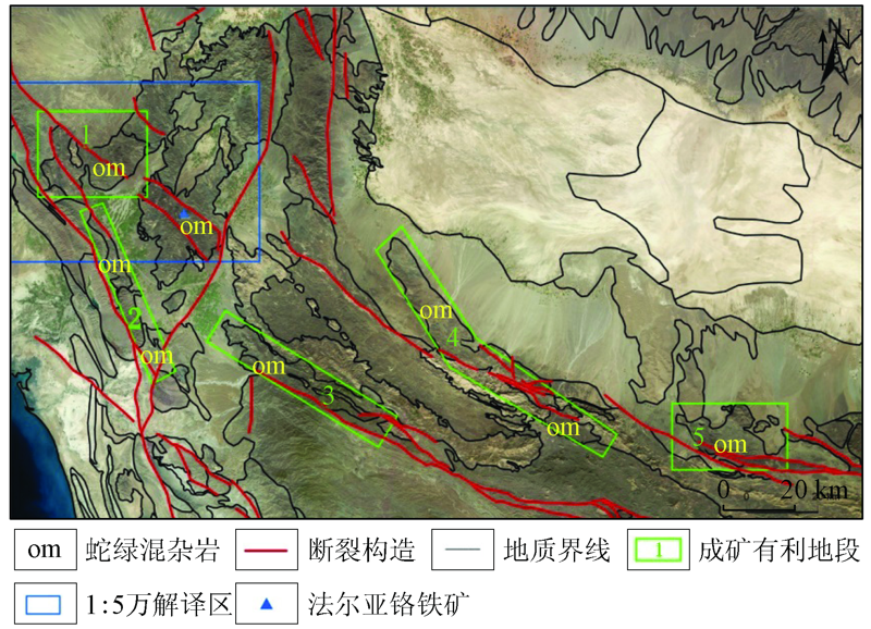
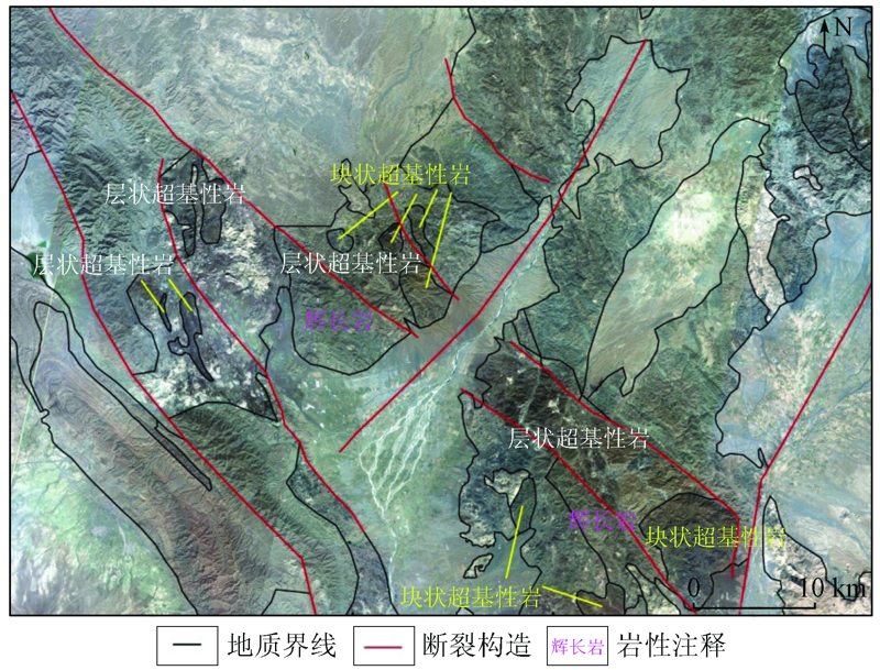
Abstract Recently, with the continuous development of domestic satellites, the quantity and the quality of remote sensing data have been improved observably, the needs of “Belt and Road initiative” in remote sensing geological investigation can be satisfied. In this paper, the authors carried out interpretation of geology and minerals in the southern part of Iran which is an area abundant of chromite based on GF-1 satellite data. The authors studied regional geological background and metallogenic condition and proposed the favorable areas for mineralization. Through the study of interpretation, it is found that the layered ultrabasic rocks in the northwest of Sorkband complex have a good prospect of chromite exploration, and it also verifies the good application effect of domestic GF-1 data in the overseas geological and mineral survey. This study is aimed at supporting the establishing of the system for domestic geological survey and making suggestions for mining enterprise.
|
| Keywords
domestic satellite data
abroad
geological minerals survey
|
|
|
|
Issue Date: 18 March 2021
|
|
|
| [1] |
Mohammad R J, Frank M, Jerzy L, et al. Review of platinum-group element distribution and mineralogy in chromitite ores from southern Iran[J]. Ore Geology Reviews, 2012,48:278-305.
|
| [2] |
Mansour G. The economic geology of Iran[M]. Tehran,Iran:Springer Dordrecht Heidelberg New York London, 2012: 46-51.
|
| [3] |
Hillebrand J. Chromite deposits in the province of Kerman,Iran[J]. Ind.Miner, 1983,5:35-43.
|
| [4] |
Sengör A M C. Mid-Mesozoic closure of Permo-Triassic Tethys and its implications[J]. Nature, 1979,279:590-593.
|
| [5] |
Stöcklin J. Structural correlation of the Alpine range between Iran and Central Asia[J]. Mémoire Hors-Série No.8 de la Société Géologique de la France, 1977,8:333-353.
|
| [6] |
Wensink H, Varekamp J C. Paleo-magnetism of basalts from Alborz:Iran part of Asia in the Cretaceous[J]. Tectonophysics, 1980,68:113-129.
|
| [7] |
Babaie H A, Ghazi A M, Babaie A, et al. Geochemistry of arc volcanic rocks of the Zagros Crush Zone,Neyriz,Iran[J]. Journal of Asian Earth Sciences, 2001,19:61-76.
|
| [8] |
Babaie H A, Babaie A, Ghazi A M, et al. Tectonic evolution of the Neyriz ophiolite,Iran:An accretionary prism model[J]. Ofioliti, 2005,30:65-74.
|
| [9] |
中国地质调查局发展研究中心. 全球矿产资源信息系统数据库建设之四十二.亚洲卷:伊朗[M]. 北京:中国地质调查局发展研究中心, 2016: 41-42.
|
| [9] |
Development and Research Center of China Geological Survey. The No.42 database establishment of the global mineral resources information systerm.Asia:Iran[M]. Beijing:Development and Research Center of China Geological Survey, 2016: 41-42.
|
| [10] |
Alinia F, Facherabadi A. Geochemical exploration and economic geological investigation for Ni,Co,PGE in sulphide mineralization in chromitite and pyroxenite of Sikhuran,Esfandagheh area,Kerman,Iran[C]// Abstracts to 20th World Mining Congress, 2005: 453-455.
|
| [11] |
Najafzadeh A R, Arvin M, Pan Y, et al. Podiform chromitites in the Sorkhband ultramafic complex,southern Iran:Evidence for ophiolithic chromitite[J] Journal of Sciences Islamic Republic of Iran, 2008,19:49-65.
|
|
Viewed |
|
|
|
Full text
|
|
|
|
|
Abstract
|
|
|
|
|
Cited |
|
|
|
|
| |
Shared |
|
|
|
|
| |
Discussed |
|
|
|
|
 2021,
Vol. 33
2021,
Vol. 33
 ), LU Yunge, SUN Ang, LI Yongzhi, LIAN Zheng