|
|
 |
|

|
|
|
A study on hidden risks of glacial lake outburst floods based on relief amplitude: A case study of eastern Shishapangma |
HE Peng1,2( ), TONG Liqiang2(), GUO Zhaocheng2, TU Jienan2, WANG Genhou1 ), TONG Liqiang2(), GUO Zhaocheng2, TU Jienan2, WANG Genhou1 |
1. School of Earth Sciences and Resources, China University of Geosciences(Beijing), Beijing 100083, China
2. China Aero Geophysical Survey and Remote Sensing Center for Natural Resources, Beijing 100083, China |
|
|
|
|
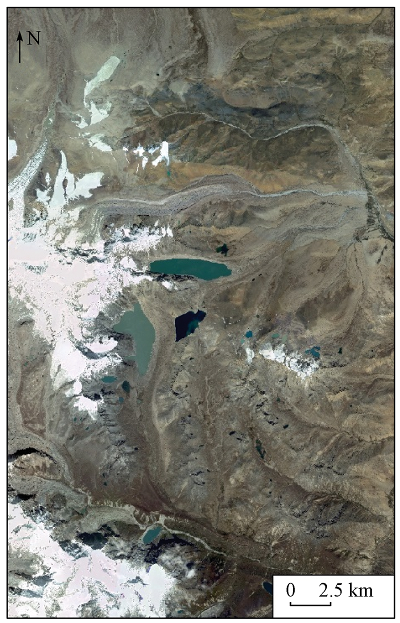
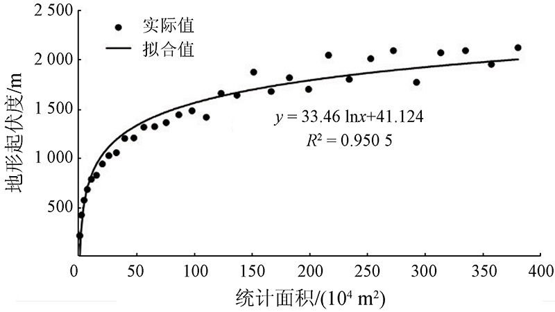
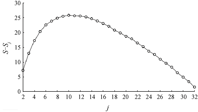
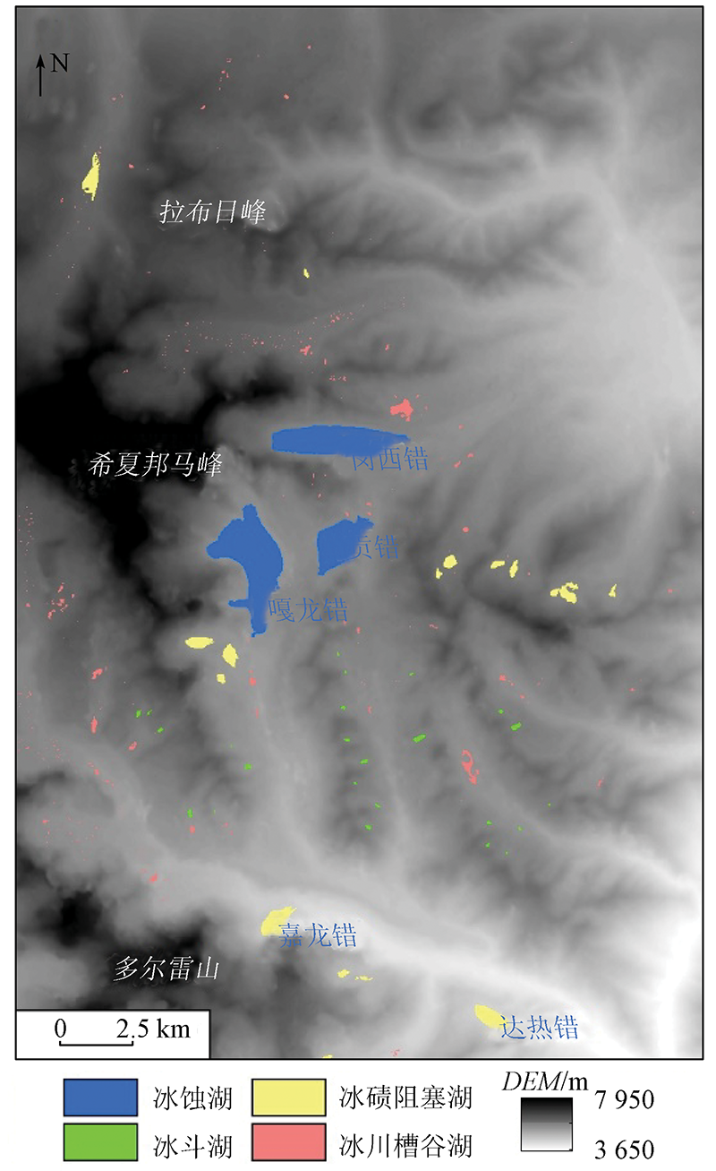
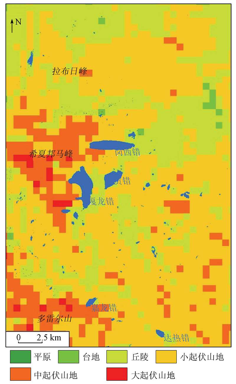
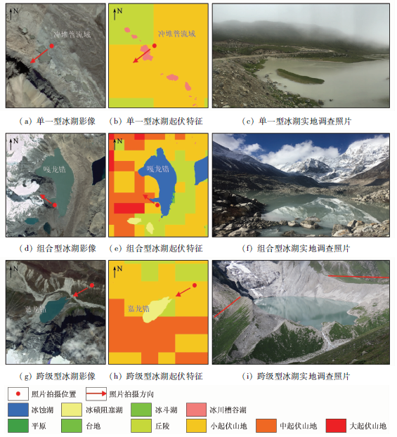
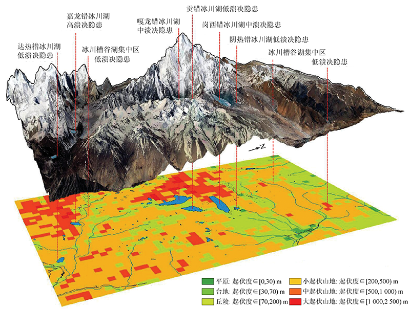
Abstract As an important indicator reflecting the geological sensitivity of slopes, relief amplitude is significant for assessing hidden risks of glacial lake outburst floods. This study obtained information on the current status of glacial lakes in the glacial lake concentrated area in the eastern Shishapangma, southern Tibet through interpretation of the GF-2 and ASTER GDEM V3 data on a scale of 1∶50 000. The feature extraction of relief amplitude was conducted using the mean change point method. Then, this study conducted a correlation analysis, achieving the hidden risk rating of glacial lake outburst floods. The results are as follows: ① On a scale of 1∶50 000, the optimal sampling unit of relief amplitude is 21×21 (0.39 km2). ② The relief amplitude characteristics of glacial lakes include the single, combined, and cross-level types, of the which the risk grade increases successively. ③ Among 1 020 glacial lakes in the study area, the number of glacial lakes with low-, medium-, and high-grade hidden risks of outburst floods accounts for 97.35%, 1.77%, and 0.88%, respectively. This study revealed the practical significance of relief amplitude as an assessment index for the hidden risks of glacial lake outburst floods. Furthermore, this study can provide theoretical references for related studies of similar areas.
|
| Keywords
remote sensing (RS)
relief amplitude
mean change point method
Shishapangma
hidden risks of glacial lake outburst floods
|
|
|
|
Corresponding Authors:
TONG Liqiang
E-mail: hepeng@mail.cgs.gov.cn;tlqhx@outlook.com
|
|
Issue Date: 14 March 2022
|
|
|
| [1] |
Diaz H F, Beniston M, Bradley R S. Climate change at high elevations discussed at workshop[J]. EOS Transactions American Geophysical Union, 1995, 76(50):516-516.
|
| [2] |
Richardson S D, Reynolds J M. An overview of glacial hazards in the Himalayas[J]. Quaternary International, 2000, 65(99):31-47.
|
| [3] |
吕儒仁. 西藏泥石流与环境[M]. 成都: 成都科技大学出版社, 1999:69-109.
|
| [3] |
Lyu R R. Debris flow and environment in Tibet[M]. Chengdu: Chengdu University of Science and Technology Press, 1999:69-109.
|
| [4] |
王伟财. 藏东南伯舒拉岭地区冰湖变化及危险性与影响分析[D]. 北京:中国科学院大学, 2013.
|
| [4] |
Wang W C. Analysis on the change,risk and impact of glacial lakes in boshula mountains,southeastern Tibet[D]. Beijing: University of Chinese Academy of Sciences, 2013.
|
| [5] |
姚晓军, 刘时银, 孙美平, 等. 20世纪以来西藏冰湖溃决灾害事件梳理[J]. 自然资源学报, 2014, 29(8):1377-1390.
|
| [5] |
Yao X J, Liu S Y, Sun M P, et al. Study on the glacial lake outburst flood events in Tibet since the 20th century[J]. Journal of Natural Resources, 2014, 29(8):1377-1390.
|
| [6] |
刘建康, 张佳佳, 高波, 等. 我国西藏地区冰湖溃决灾害综述[J]. 冰川冻土, 2019, 41(6):1335-1347.
|
| [6] |
Liu J K, Zhang J J, Gao B, et al. An overview of glacial lake outburst flood in Tibet,China[J]. Journal of Glaciology and Geocryolo-gy, 2019, 41(6):1335-1347.
|
| [7] |
刘建康, 周路旭. 国内外冰碛湖溃决研究进展[J]. 探矿工程(岩土钻掘工程), 2018, 45(8):44-50.
|
| [7] |
Liu J K, Zhou L X. Research progress on moraine dammed lake outburst flood[J]. Exploration Engineering(Rock and Soil Drilling and Tunneling), 2018, 45(8):44-50.
|
| [8] |
童立强, 裴丽鑫, 涂杰楠, 等. 冰崩灾害的界定与类型划分——以青藏高原地区为例[J]. 自然资源遥感, 2020, 32(2):11-18.doi: 10.6046/gtzyyg.2020.02.02.
doi: 10.6046/gtzyyg.2020.02.02
|
| [8] |
Tong L Q, Pei L X, Tu J N, et al. A preliminary study of definition and classification of ice avalanche in the Tibetan Plateau region[J]. Remote Sensing for Land and Resources, 2020, 32(2):11-18.doi: 10.6046/gtzyyg.2020.02.02.
doi: 10.6046/gtzyyg.2020.02.02
|
| [9] |
周路旭, 刘建康, 陈龙. 藏东南交通干线(林芝段)冰湖溃决危险性分析与评价[J]. 自然灾害学报, 2020, 29(3):162-172.
|
| [9] |
Zhou L X, Liu J K, Chen L. Risk analysis and evaluation of glacier lake outburst in traffic route of southeast Tibet(Linzhi)[J]. Journal of Natural Disasters, 2020, 29(3):162-172.
|
| [10] |
Pourghasemi H R, Pradhan B, Gokceoglu G. Application of fuzzy logic and analytical hierarchy process (AHP) to landslide susceptibility mapping at Haraz watershed,Iran[J]. Natural Hazards, 2012, 63(2):965-996.
doi: 10.1007/s11069-012-0217-2
url: http://link.springer.com/10.1007/s11069-012-0217-2
|
| [11] |
张明媚, 薛永安. 斜坡地质灾害敏感性评价中地势起伏度提取最佳尺度研究[J]. 太原理工大学学报, 2020, 51(6):881-888.
|
| [11] |
Zhang M M, Xue Y A. Optimal scale for extracting relief amplitude in slope geological hazard sensitivity evaluation[J]. Journal of Taiyuan University of Technology, 2020, 51(6):881-888.
|
| [12] |
涂汉明, 刘振东. 中国地势起伏度最佳统计单元的求证[J]. 湖北大学学报(自然科学版), 1990(3):266-271.
|
| [12] |
Xu H M, Liu Z D. Demonstrating on optimum statistic unit of relief amplitude in China[J]. Journal of Hubei University(Natural Science Edition), 1990(3):266-271.
|
| [13] |
Kanwarpreet S, Virender K. Hazard assessment of landslide disaster using information value method and analytical hierarchy process in highly tectonic Chamba region in bosom of Himalaya[J]. Journal of Mountain Science, 2018, 15(4):808-824.
doi: 10.1007/s11629-017-4634-2
url: https://doi.org/10.1007/s11629-017-4634-2
|
| [14] |
刘爱利, 汤国安. 中国地貌基本形态DEM的自动划分研究[J]. 地球信息科学, 2006(4):8-14,5.
|
| [14] |
Liu A L, Tang G A. DEM based auto-classification of Chinese landform[J]. Geo-Information Science, 2006(4):8-14,5.
|
| [15] |
韩海辉, 高婷, 易欢, 等. 基于变点分析法提取地势起伏度——以青藏高原为例[J]. 地理科学, 2012, 32(1):101-104.
doi: 10.13249/j.cnki.sgs.2012.01.101
|
| [15] |
Han H H, Gao T, Yi H, et al. Extraction of relief amplitude based on change point method: A case study on the Tibetan Plateau[J]. Scientia Geographica Sinica, 2012, 32(1):101-104.
|
| [16] |
张军, 李晓东, 陈春艳, 等. 新疆地势起伏度的分析研究[J]. 兰州大学学报(自然科学版), 2008(s1):10-13,19.
|
| [16] |
Zhang J, Li X D, Chen C Y, et al. Analysis and research on relief relief of Xinjiang[J]. Journal of Lanzhou University(Natural Science Edition), 2008(s1):10-13,19.
|
| [17] |
毕晓玲, 李小娟, 胡卓玮, 等. 地形起伏度提取及其在区域滑坡灾害评价中的应用——以四川省为例[J]. 安徽农业科学, 2011, 39(4):2413-2416,2441.
|
| [17] |
Bi X L, Li X J, Hu Z W, et al. The extraction of relief amplitude and its application in the regional landslide hazard assessment[J]. Anhui Agricultural Science, 2011, 39(4):2413-2416,2441.
|
| [18] |
千琳勃, 宋友桂. 基于DEM的六盘山地势起伏度研究[J]. 地球环境学报, 2011, 2(4):510-515.
|
| [18] |
Qian L B, Song Y G. Analysis of relief amplitude in Liupan Mountain based on DEM[J]. Journal of Earth Environment, 2011, 2(4):510-515.
|
| [19] |
张竞, 杜东, 白耀楠, 等. 基于DEM的京津冀地区地形起伏度分析[J]. 中国水土保持, 2018(9):33-37.
|
| [19] |
Zhang J, Du D, Bai Y N, et al. Analysis of terrain fluctuation in Beijing,Tianjin and Hebei based on DEM[J]. Soil and Water Conservation in China, 2018(9):33-37.
|
| [20] |
王岩, 刘少峰. 基于DEM的青海贵德地区地形起伏度的研究[J]. 地质通报, 2008, 27(12):2117-2121.
|
| [20] |
Wang Y, Liu S F. DEM research on the local relief in the Guide area,Qinghai,China[J]. Geological Bulletin, 2008, 27(12):2117-2121.
|
| [21] |
赵斌滨, 程永锋, 丁士君, 等. 基于SRTM-DEM的我国地势起伏度统计单元研究[J]. 水利学报, 2015, 46(s1):284-290.
|
| [21] |
Zhao B B, Cheng Y F, Ding S J, et al. Statistical unit of relief amplitude in China based on SRTM-DEM[J]. Journal of Hydraulic Engineering, 2015, 46(s1):284-290.
|
| [22] |
李建忠, 邹光富, 冯心涛, 等. 珠穆朗玛峰地区新构造运动与环境地质灾害[J]. 地质灾害与环境保护, 2004(2):6-10.
|
| [22] |
Li J Z, Zhou G F, Feng X T, et al. Neotectonism and environmental geohazards,Mt Zhumulangma area[J]. Geological Disasters and Environmental Protection, 2004(2):6-10.
|
| [23] |
崔鹏, 陈容, 向灵芝, 等. 气候变暖背景下青藏高原山地灾害及其风险分析[J]. 气候变化研究进展, 2014, 10(2):103-109.
|
| [23] |
Cui P, Chen R, Xiang L Z, et al. Risk analysis of mountain hazards in Tibetan Plateau under global warming[J]. Progressus Inquisitiones de Mutatione Climatis, 2014, 10(2):103-109.
|
| [24] |
吴坤鹏, 刘时银, 鲍伟佳, 等. 1980—2015年青藏高原东南部岗日嘎布山冰川变化的遥感监测[J]. 冰川冻土, 2017, 39(1):24-34.
|
| [24] |
Wu K P, Liu S Y, Bao W J, et al. Remote sensing monitoring of the glacier change in the Gangrigabu Range,southeast Tibetan Plateau from 1980 through 2015[J]. Journal of Glaciology and Geocryology, 2017, 39(1):24-34.
|
| [25] |
李震, 陈宁生, 张建平, 等. 波曲流域冰湖及其溃决灾害链特征分析[J]. 水文地质工程地质, 2014, 41(4):143-148,152.
|
| [25] |
Li Z, Chen N S, Zhang J P, et al. Characteristics of the disaster chain of outburst and glacier lakes in the Boiqu River basin[J]. Hydrogeology and Engineering Geology, 2014, 41(4):143-148,152.
|
| [26] |
Abrams M, Crippen R, Fujisada H. ASTER global digital elevation model (GDEM) and ASTER global water body dataset (ASTWBD)[J]. Remote Sensing, 2020, 12(7):1156-1168.
doi: 10.3390/rs12071156
url: https://www.mdpi.com/2072-4292/12/7/1156
|
| [27] |
陈晓清, 崔鹏, 杨忠, 等. 聂拉木县冲堆普2002年泥石流成因分析及防治对策[J]. 冰川冻土, 2006(5):776-781.
|
| [27] |
Chen X Q, Cui P, Yang Z, et al.Debris flows of Chongdui Gully in Nyalam County, 2002: Cause and control[J]. Journal of Glaciology and Geocryology, 2006(5):776-781.
|
|
Viewed |
|
|
|
Full text
|
|
|
|
|
Abstract
|
|
|
|
|
Cited |
|
|
|
|
| |
Shared |
|
|
|
|
| |
Discussed |
|
|
|
|
 2022,
Vol. 34
2022,
Vol. 34