|
|
|
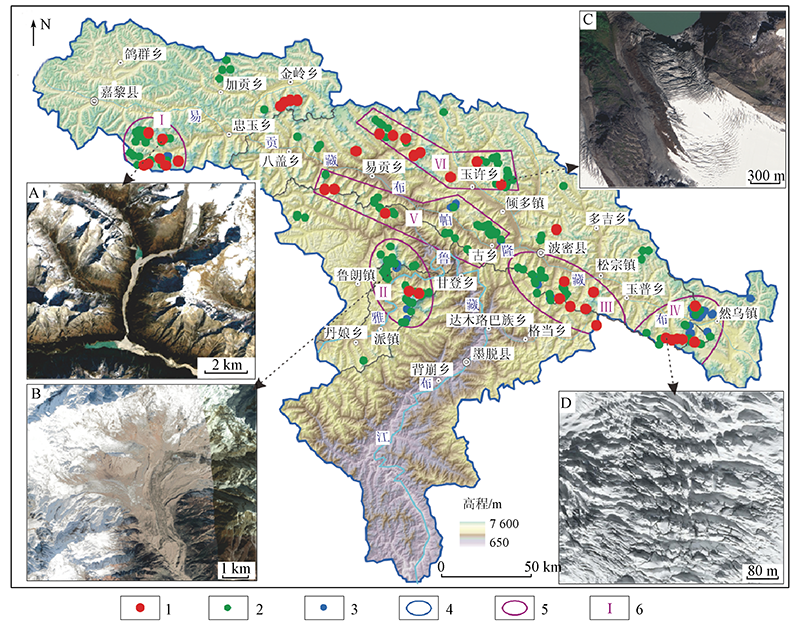
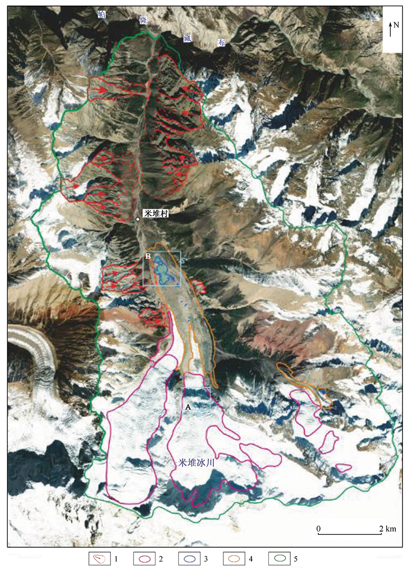
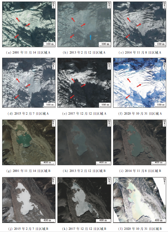
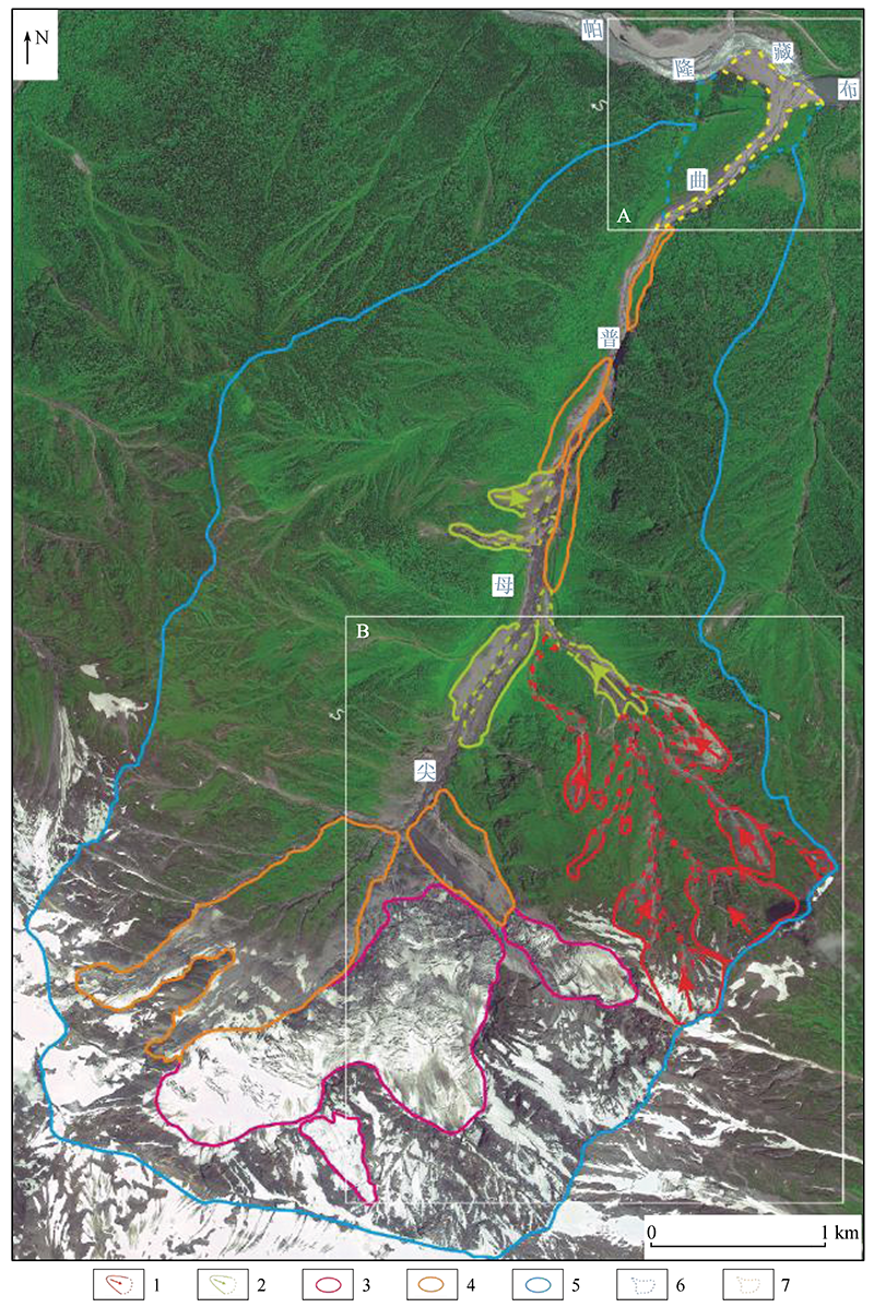
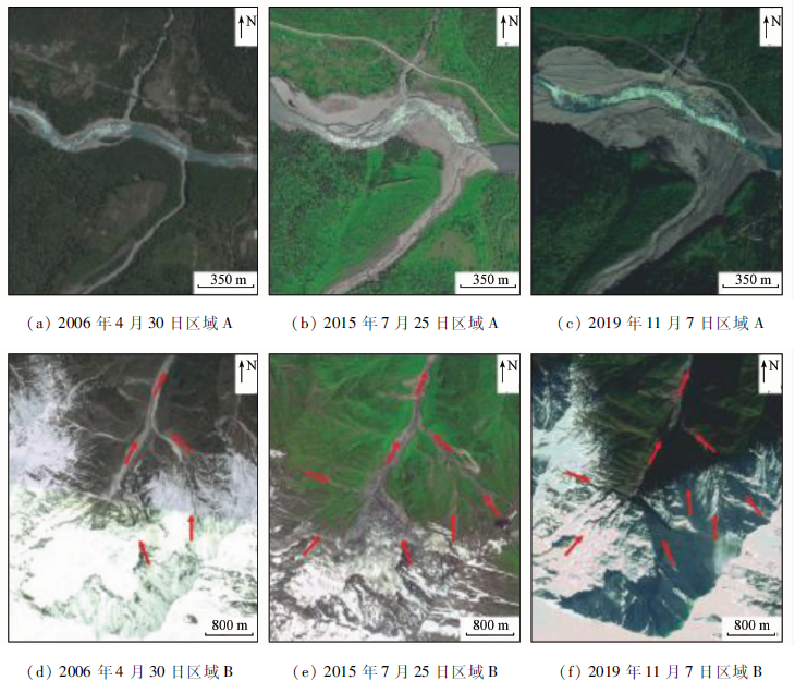
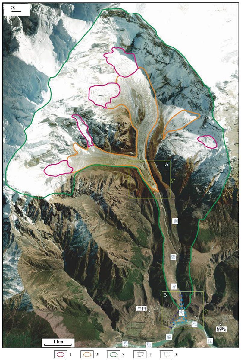
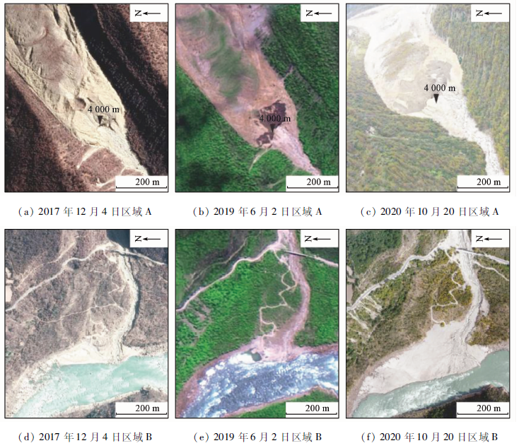
Abstract Glaciers are widely distributed in southeast Tibet. Glacier instability is prominent in this region against the backdrop of global warming. Surveys of the potential hazards of ice avalanches using optical remote sensing are practically significant for disaster prevention and mitigation in the region. According to the hue, morphology, texture, and shadow characteristics of the potential hazards of ice avalanches on remote sensing images, this study established the symbols of remote sensing interpretation of potential hazards of ice avalanches in the study area. Based on this, a total of 232 potential hazards of ice avalanches were interpreted in southeast Tibet, including 47 large, 147 super large, and 38 giant ones. Then, this study analyzed the essential characteristics and spatial distribution of the potential hazards based on the characteristics of terrain, landform, and regional geological environment. Consequently, four concentrated distribution areas and two concentrated distribution zones were determined. The potential hazards of ice avalanches in the study area show distinct chain characteristics. According to the spatio-temporal relationships between the potential hazards and their possible secondary disasters, the ice avalanche disaster chains in southeast Tibet can be divided into three types, namely, ice avalanche - glacial lake outburst flood - debris flow disaster chains, ice avalanche - debris flow - barrier lake - flood disaster chains, and ice avalanche - debris flow disaster chains. Taking the potential hazard chains of ice avalanches in Miduigou, Jianmupuqu, and Zelongnonggou as examples, this study analyzed the dynamic change characteristics and chain structure of these potential hazard chains using optical remote sensing technology. The purpose is to provide basic data for an in-depth study on potential hazards of ice avalanches in southeast Tibet.
|
| Keywords
optical remote sensing
potential hazards of ice avalanches
disaster chain
southeast Tibet
|
|
|
|
Corresponding Authors:
WANG Meng
E-mail: liuwen2009.hi@163.com;wangmengscrs@qq.com
|
|
Issue Date: 14 March 2022
|
|
|
| [1] |
童立强, 裴丽鑫, 涂杰楠, 等. 冰崩灾害的界定与类型划分——以青藏高原地区为例[J]. 自然资源遥感, 2020, 32(2):11-18.doi: 10.6046/gtzyyg.2020.02.02.
doi: 10.6046/gtzyyg.2020.02.02
|
| [1] |
Tong L Q, Pei L X, Tu J N, et al. A preliminary study of definition and classification of ice avalanche in the Tibetan Plateau region[J]. Remote Sensing for Land and Resources, 2020, 32(2):11-18.doi: 10.6046/gtzyyg.2020.02.02.
doi: 10.6046/gtzyyg.2020.02.02
|
| [2] |
Sangewar C V. Remote sensing applications to study Indian glaciers[J]. Geocarto International, 2012, 27(3):197-206.
doi: 10.1080/10106049.2011.617841
url: http://www.tandfonline.com/doi/abs/10.1080/10106049.2011.617841
|
| [3] |
Leinss S, Bernardini E, Jacquemart M, et al. Glacier detachments and rock-ice avalanches in the Petra Pervogo range,Tajikistan (1973—2019)[J]. Natural Hazards and Earth System Sciences, 2021, 21(5):1409-1429.
|
| [4] |
Gilbert A, Leinss S, Kargel J, et al. Mechanisms leading to the 2016 giant twin glacier collapses,Aru Range,Tibet[J]. The Cryosphere, 2018, 12(9):2883-2900.
doi: 10.5194/tc-12-2883-2018
url: https://tc.copernicus.org/articles/12/2883/2018/
|
| [5] |
Kääb A, Leinss S, Gilbert A, et al. Massive collapse of two glaciers in western Tibet in 2016 after surge-like instability[J]. Nature Geoscience, 2018, 11(2):114-120.
doi: 10.1038/s41561-017-0039-7
url: https://doi.org/10.1038/s41561-017-0039-7
|
| [6] |
Wang S, Yang B, Zhou Y, et al. Snow cover mapping and ice avalanche monitoring from the satellite data of the sentinels[J]. ISPRS-International Archives of the Photogrammetry, Remote Sensing and Spatial Information Sciences, 2018, XLII- 3:1765-1772.
|
| [7] |
Margreth S, Funk M, Tobler D, et al. Analysis of the hazard caused by ice avalanches from the hanging glacier on the Eiger west face[J]. Cold Regions Science and Technology, 2017, 144:63-72.
doi: 10.1016/j.coldregions.2017.05.012
url: https://linkinghub.elsevier.com/retrieve/pii/S0165232X1630369X
|
| [8] |
姚檀栋, 邬光剑, 徐柏青, 等. “亚洲水塔”变化与影响[J]. 中国科学院院刊, 2019, 34(11):1203-1209.
|
| [8] |
Yao T D, Wu G J, Xu B Q, et al. Asian water tower change and its impacts[J]. Bulletin of Chinese Academy of Sciences, 2019, 34(11):1203-1209.
|
| [9] |
姚檀栋, 余武生, 邬光剑, 等. 青藏高原及周边地区近期冰川状态失常与灾变风险[J]. 科学通报, 2019, 64(27):2770-2782.
|
| [9] |
Yao T D, Yu W S, Wu G J, et al. Glacier anomalies and relevant disaster risks on the Tibetan Plateau and surroundings[J]. Chinese Science Bulletin, 2019, 64(27):2770-2782.
|
| [10] |
裴丽鑫. 青藏高原地区冰崩灾害特征与类型的初步研究[D]. 北京:中国地质大学(北京),2019.
|
| [10] |
Pei L X. The preliminary study of characteristics and types of ice avalanche disaster in the Tibetan Plateau[D]. Beijing:China University of Geosciences(Beijing),2019.
|
| [11] |
胡文涛, 姚檀栋, 余武生, 等. 高亚洲地区冰崩灾害的研究进展[J]. 冰川冻土, 2018, 40(6):1141-1152.
|
| [11] |
Hu W T, Yao T D, Yu W S, et al. Advances in the study of glacier avalanches in high Asia[J]. Journal of Glaciology and Geocryology, 2018, 40(6):1141-1152.
|
| [12] |
Geng Q R, Pan G T, Zheng L L, et al. The eastern Himalayan syntaxis:Major tectonic domains,ophiolitic mélanges and geologic evolution[J]. Journal of Asian Earth Sciences, 2006, 27(3):265-285.
doi: 10.1016/j.jseaes.2005.03.009
url: https://linkinghub.elsevier.com/retrieve/pii/S1367912005000878
|
| [13] |
Deng Q D, Zhang P Z, Ran Y K, et al. Basic characteristics of active tectonics of China[J]. Science in China Series D:Earth Sciences, 2003, 46(4):356-372.
|
| [14] |
Ding L, Zhong D L, Yin A, et al. Cenozoic structural and metamorphic evolution of the eastern Himalayan syntaxis(Namche Barwa)[J]. Earth and Planetary Science Letters, 2001, 192(3):423-438.
doi: 10.1016/S0012-821X(01)00463-0
url: https://linkinghub.elsevier.com/retrieve/pii/S0012821X01004630
|
| [15] |
刘金花, 易朝路, 李英奎. 藏南卡鲁雄峰枪勇冰川新冰期冰川发育探讨[J]. 第四纪研究, 2018, 38(2):348-354.
|
| [15] |
Liu J H, Yi C L, Li Y K. Reconstruction of the neoglacial glaciers in the Qiangyong valley,Mt.Kaluxung,south Tibet[J]. Quaternary Sciences, 2018, 38(2):348-354.
|
| [16] |
Röthlisberger H. Ice avalanches[J]. Journal of Glaciology, 1977, 19(81):669-671.
doi: 10.1017/S0022143000029580
url: https://www.cambridge.org/core/product/identifier/S0022143000029580/type/journal_article
|
| [17] |
黄宗理, 张良弼. 地球科学大辞典——应用学科卷[M]. 北京: 地质出版社, 2005.
|
| [17] |
Huang Z L, Zhang L B. A dictionary of earth sciences[M]. Beijing: Geological Press, 2005.
|
| [18] |
刘建康, 张佳佳, 高波, 等. 我国西藏地区冰湖溃决灾害综述[J]. 冰川冻土, 2019, 41(6):1335-1347.
|
| [18] |
Liu J K, Zhang J J, Gao B, et al. An overview of glacial lake outburst flood in Tibet,China[J]. Journal of Glaciology and Geocryolo-gy, 2019, 41(6):1335-1347.
|
|
Viewed |
|
|
|
Full text
|
|
|
|
|
Abstract
|
|
|
|
|
Cited |
|
|
|
|
| |
Shared |
|
|
|
|
| |
Discussed |
|
|
|
|
 2022,
Vol. 34
2022,
Vol. 34
 ), WANG Meng(