|
|
|
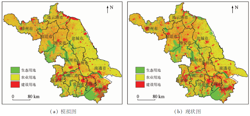
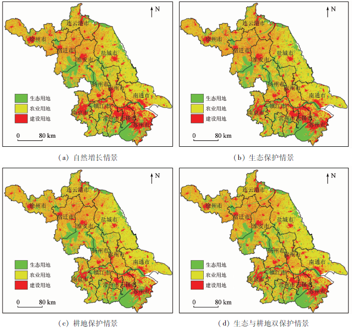
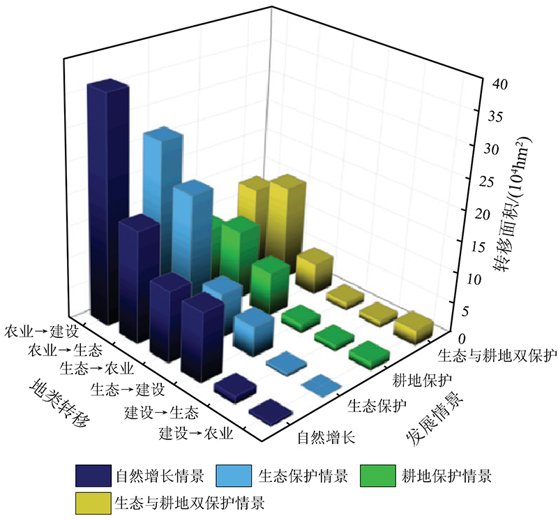
Abstract This study aims to assist Jiangsu Province in selecting the regional development modes suitable for its local conditions. To this end, this study identified the driving factors in the evolution of the land use pattern in Jiangsu Province by comprehensively using three regression methods (i.e., Logistic, Auto-Logistic, and SBS-Logistic). Then, this study simulated the spatial pattern of ecology-agriculture-construction land in Jiangsu Province in 2030 under four scenarios using the Markov-CLUES model. The results are as follows. ①The accuracy of the three regression methods was in the order of Auto-Logistic > SBS-Logistic > Logistic. The ROC values of the three land use types obtained using the Auto-Logistic regression method were all over 0.75. The Markov-CLUES model performed well in the verification simulation of the land use pattern in Jiangsu Province during 2005—2018, with a Kappa coefficient of 0.758 according to the accuracy evaluation. ②The rapid development in the “Three Circles” and “Four Lines” areas will be guaranteed under the scenario of natural growth in 2030. However, some rivers will narrow, threatening food security and leading to weak development sustainability. For the scenario of ecological protection, the environment of river canals and areas surrounding lakes will be greatly improved by controlling and managing ecology. For the scenario of cultivated land protection, high-quality cultivated land in the main grain-producing areas will be effectively protected, and the cultivated land area in northern and central Jiangsu will obviously increase. The dual protection of both ecology and cultivated land will allow for strong sustainable development and the effective restriction of the disorderly expansion of construction land in 2030. However, the contradiction between demand and supply of construction land will be prominent in a short term. ③It is advisable to adopt the development mode of protecting ecology in the Taihu Lake, the Huai River basin, the conservation areas of Yangtze River wetland, and coastal areas, to adopt the development mode of protecting cultivated land in the Subei and Suzhong plains, and to adopt the development mode of protecting both ecology and cultivated land in the five cities in southern Jiangsu. Given the further implementation of the development strategy along the Yangtze River, the development mode of natural growth can be adopted in Yangzhou and Taizhou cities in central Jiangsu Province. This study revealed the spatio-temporal evolutionary laws of the spatial pattern of ecology-agriculture-construction land in Jiangsu Province. The simulation of the spatial pattern under various scenarios will provide decision support for Jiangsu Province to achieve regional development modes suitable for local conditions and assist Jiangsu Province in forming the spatial pattern of land where ecology-agriculture-construction land couples mutually and develops in a coordinated manner.
|
| Keywords
SBS-Logistic regression
Auto-Logistic regression
CLUE-S model
regional development mode
“ecology-agriculture-construction” land;
Jiangsu Province
|
|
|
|
Corresponding Authors:
KONG Xuesong
E-mail: 2780296299@qq.com;xuesongk@whu.edu.cn
|
|
Issue Date: 14 March 2022
|
|
|
| [1] |
邱建军, 唐华俊, 陈佑启, 等. 中国土地利用/土地覆被变化研究[M]. 北京: 中国农业科学技术出版社, 2004.
|
| [1] |
Qiu J J, Tang H J, Chen Y Q, et al. Study on land use/land cover change in China[M]. Beijing: China Agricultural Science and Technology Press, 2004.
|
| [2] |
尚勇敏, 曾刚. 区域经济发展模式内涵、标准的再探讨[J]. 经济问题探索, 2015(1):62-67.
|
| [2] |
Shang Y M, Zeng G. Re-discussion on the connotation and standard of regional economic development mode[J]. Inquiry into Economic Issues, 2015(1):62-67.
|
| [3] |
侯鹏, 王桥, 王昌佐, 等. 流域土地利用/土地覆被变化的生态效应[J]. 地理研究, 2011, 30(11):2092-2098.
|
| [3] |
Hou P, Wang Q, Wang C Z, et al. Ecological effect of land-use and land-cover change in a watershed scope[J]. Geographical Research, 2011, 30(11):2092-2098.
|
| [4] |
李秀彬. 全球环境变化研究的核心领域──土地利用/土地覆被变化的国际研究动向[J]. 地理学报, 1996(6):553-558.
|
| [4] |
Li X B. A review of the international researches on land use/land cover change[J]. Acta Geographica Sinica, 1996(6):553-558.
|
| [5] |
郭燕燕. 基于CLUE-S模型的深圳市土地利用变化模拟[D]. 武汉:武汉大学, 2017.
|
| [5] |
Guo Y Y. Simulation of land use change in Shenzhen based on CLUE-S model[D]. Wuhan:Wuhan University, 2017.
|
| [6] |
曾刚, 尚勇敏, 司月芳. 中国区域经济发展模式的趋同演化——以中国16种典型模式为例[J]. 地理研究, 2015, 34(11):2005-2020.
doi: 10.11821/dlyj201511001
|
| [6] |
Zeng G, Shang Y M, Si Y F. The convergent evolution of China’s regional economic development models[J]. Geographical Research, 2015, 34(11):2005-2020.
|
| [7] |
郑荣宝, 卢润开, 唐晓莲, 等. 1998—2016年全球LUCC研究进展与热点分析[J]. 华侨大学学报(自然科学版), 2017, 38(5):591-601.
|
| [7] |
Zheng R B, Lu R K, Tang X L, et al. Researches progress and hot spots analysis of global LUCC research during 1998 to 2016[J]. Journal of Huaqiao University(Natural Science), 2017, 38(5):591-601.
|
| [8] |
徐姗, 王开泳, 邓羽. 区域发展模式知识库的理论阐释与顶层设计[J]. 城市发展研究, 2016, 23(7):13-17.
|
| [8] |
Xu S, Wang K Y, Deng Y. The theoretical interpretation and the top layer design of regional development model under the perspective of knowledge base[J]. Urban Development Studies, 2016, 23(7):13-17.
|
| [9] |
唐华俊, 吴文斌, 杨鹏, 等. 土地利用/土地覆被变化(LUCC)模型研究进展[J]. 地理学报, 2009, 64(4):456-468.
|
| [9] |
Tang H J, Wu W B, Yang P, et al. Recent progresses of land use and land cover change(LUCC) models[J]. Acta Geographica Sinica, 2009, 64(4):456-468.
|
| [10] |
吴桂平. CLUE-S模型的改进与区域土地利用变化模拟[D]. 长沙:中南大学, 2008.
|
| [10] |
Wu G P. Improvement of CLUE-S model and simulation of regional land use change[D]. Changsha:Central South University, 2008.
|
| [11] |
杭云飞. 基于改进的CLUE-S模型的土地利用变化动态模拟与情景分析[D]. 南京:南京信息工程大学, 2014.
|
| [11] |
Hang Y F. Dynamic simulation and scenario analysis of land use change based on the improved CLUE-S model[D]. Nanjing:Nanjing University of Information Science and Technology, 2014.
|
| [12] |
刘甲红, 徐露洁, 潘骁骏, 等. 土地利用/土地覆盖变化情景模拟研究进展[J]. 杭州师范大学学报(自然科学版), 2017, 16(5):551-560.
|
| [12] |
Liu J H, Xu L J, Pan X J, et al. Research progress on land-use and land-cover change scenario simulation[J]. Journal of Hangzhou Normal University(Natural Science Edition), 2017, 16(5):551-560.
|
| [13] |
Verburg P H, Soepboer W, Veldkamp A, et al. Modeling the spatial dynamics of regional land use:The CLUE-S model[J]. Environmental Management, 2002, 30(3):391-405.
pmid: 12148073
|
| [14] |
王丽艳, 张学儒, 张华, 等. CLUE-S模型原理与结构及其应用进展[J]. 地理与地理信息科学, 2010, 26(3):73-77.
|
| [14] |
Wang L Y, Zhang X R, Zhang H, et al. Principle and structure of CLUE-S model and its progresses[J]. Geography and Geo-Information Science, 2010, 26(3):73-77.
|
| [15] |
Verburg P H, Overmars K P. Dynamics simulation of land-use change trajectories with the CLUE-S model in Koomen[J]. The Geo-Journal Library, 2007, 90(5):321-337.
|
| [16] |
李鑫, 马晓冬, 肖长江, 等. 基于CLUE-S模型的区域土地利用布局优化[J]. 经济地理, 2018, 35(1):162-167.
|
| [16] |
Li X, Ma X D, Xiao C J, et al. The regional land use layout optimization based on the CLUE-S model[J]. Economic Geography, 2018, 35(1):162-167.
|
| [17] |
张永民, 赵士洞, Verburg P H. CLUE-S模型及其在奈曼旗土地利用时空动态变化模拟中的应用[J]. 自然资源学报, 2003(3):310-318.
|
| [17] |
Zhang Y M, Zhao S D, Verburg P H. CLUE-S and its application for simulating temporal and spatial change of land use in Naiman Banner[J]. Journal of Natural Resources, 2003(3):310-318.
|
| [18] |
Chu H, Wu C, Lin Y. Incorporating spatial autocorrelation with neural networks in empirical land-use change models[J]. Environment and Planning, 2013, 40(3):384-404.
|
| [19] |
王祺, 蒙吉军, 毛熙彦. 基于邻域相关的漓江流域土地利用多情景模拟与景观格局变化[J]. 地理研究, 2014, 33(6):1073-1084.
doi: 10.11821/dlyj201406008
|
| [19] |
Wang Q, Meng J J, Mao X Y. Scenario simulation and landscape pattern assessment of land use change based on neighborhood analysis and auto-logistic model:A case study of Lijiang River basin[J]. Geographical Research, 2014, 33(6):1073-1084.
|
| [20] |
吴桂平, 曾永年, 冯学智, 等. CLUE-S模型的改进与土地利用变化动态模拟——以张家界市永定区为例[J]. 地理研究, 2010, 29(3):460-470.
|
| [20] |
Wu G P, Zeng Y N, Feng X Z, et al. Dynamic simulation of land use change based on the improved CLUE-S model:A case study of Yongding County,Zhangjiajie[J]. Geographical Research, 2010, 29(3):460-470.
|
| [21] |
Castella J C, Verburg P H. Combination of process-oriented and pattern-oriented models of land use change in a mountain area of Vietnam[J]. Ecological Modeling, 2007, 202(3-4):410-420.
doi: 10.1016/j.ecolmodel.2006.11.011
url: https://linkinghub.elsevier.com/retrieve/pii/S0304380006005436
|
| [22] |
田多松, 傅碧天, 吕永鹏, 等. 基于SD和CLUE-S模型的区域土地利用变化对土壤有机碳储量影响研究[J]. 长江流域资源与环境, 2016, 25(4):613-620.
|
| [22] |
Tian D S, Fu B T, Lyu Y P, et al. Effect of regional land use change on soil organic carbon storage based on SD and CLUE-S model[J]. Resources and Environment in the Yangtze Basin, 2016, 25(4):613-620.
|
| [23] |
朱春娇, 田波, 周云轩, 等. 基于Markov和CLUE-S模型的浦东新区湿地演变遥感分析与预测[J]. 复旦学报(自然科学版), 2018, 54(4):431-438.
|
| [23] |
Zhu C J, Tian B, Zhou Y X, et al. Wetland change analysis and forecasting in Pudong new area using Markov and CLUE-S model[J]. Journal of Fudan University(Natural Science), 2018, 54(4):431-438.
|
| [24] |
黄金川, 林浩曦, 漆潇潇. 面向国土空间优化的三生空间研究进展[J]. 地理科学进展, 2017, 36(3):378-391.
doi: 10.18306/dlkxjz.2017.03.014
|
| [24] |
Huang J C, Lin H X, Qi X X. A literature review on optimization of spatial development pattern based on ecological-production-living space[J]. Progress in Geography, 2017, 36(3):378-391.
|
| [25] |
吴健生, 冯喆, 高阳, 等. CLUE-S模型应用进展与改进研究[J]. 地理科学进展, 2012, 31(1):3-10.
doi: 10.11820/dlkxjz.2012.01.001
|
| [25] |
Wu J S, Feng Z, Gao Y, et al. Recent progresses on the application and improvement of the CLUE-S model[J]. Progress in Geography, 2012, 31(1):3-10.
|
| [26] |
胡和兵, 刘红玉, 郝敬锋, 等. 流域景观结构的城市化影响与生态风险评价[J]. 生态学报, 2011, 31(12):3432-3440.
|
| [26] |
Hu H B, Liu H Y, Hao J F, et al. The urbanization effects on watershed landscape structure and their ecological risk assessment[J]. Acta Ecologica Sinica, 2011, 31(12):3432-3440.
|
| [27] |
Fraser D G, Mabee W, Slaymaker O, et al. Mutual dependence:The reflexive relation between human society and the environment[J]. Global Environmental Change, 2003, 13(2):137-144.
doi: 10.1016/S0959-3780(03)00022-0
url: https://linkinghub.elsevier.com/retrieve/pii/S0959378003000220
|
| [28] |
Kaleem A M, Rasool G. Effects of different land use types on soil quality in the hilly area of raw Alako Azad Jammu and Kashmir[J]. Acta Agriculture Scandinavica, 2005, 55(3):221-228.
|
| [29] |
崔家兴, 顾江, 孙建伟, 等. 湖北省三生空间格局演化特征分析[J]. 中国土地科学, 2018, 32(8):67-73.
|
| [29] |
Cui J X, Gu J, Sun J W, et al. The spatial pattern and evolution characteristics of the production,living and ecological space in Hubei Provence[J]. China Land Science, 2018, 32(8):67-73.
|
| [30] |
王芳, 陈芝聪, 谢小平. 太湖流域建设用地与耕地景观时空演变及驱动力[J]. 生态学报, 2018, 38(9):3300-3310.
|
| [30] |
Wang F, Chen Z C, Xie X P. Analysis of spatial-temporal evolution and it’s driving forces of construction land and cultivated landscape in Taihu Lake basin[J]. Acta Ecologica Sinica, 2018, 38(9):3300-3310.
|
| [31] |
Besag J. Spatial interaction and statistical-analysis of lattice systems[J]. Journal of the Royal Statistical Society Series B-Metho-dological, 1974, 36(2):192-236.
|
| [32] |
朱文博, 张静静, 崔耀平, 等. 基于土地利用变化情景的生态系统碳储量评估——以太行山淇河流域为例[J]. 地理学报, 2019, 74(3):446-459.
doi: 10.11821/dlxb201903004
|
| [32] |
Zhu W B, Zhang J J, et al. Assessment of territorial ecosystem carbon storage based on land use change scenario:A case study in Qihe River basin[J]. Acta Geographica Sinica, 2019, 74(3):446-459.
|
| [33] |
谭永忠. 县级尺度土地利用变化驱动机制及空间格局变化模拟研究[D]. 杭州:浙江大学, 2004.
|
| [33] |
Tan Y Z. Simulation research on the driving mechanism of land use change and spatial pattern change at county level[D]. Hangzhou:Zhejiang University, 2004.
|
| [34] |
孔雪松, 朱芷晴, 刘殿锋. 江苏省乡村聚落演化的多尺度特征与空间关联性分析[J]. 农业工程学报, 2020, 36(12):247-256,329.
|
| [34] |
Kong X S, Zhu Z Q, Liu D F. Multi-scale evolution characteristics of rural settlements and spatial correlation in Jiangsu Province,China[J]. Transactions of the Chinese Society of Agricultural Engineering, 2020, 36(12):247-256,329.
|
| [35] |
孔雪松, 王静, 金志丰, 等. 面向乡村振兴的农村土地整治转型与创新思考[J]. 中国土地科学, 2019, 33(5):95-102.
|
| [35] |
Kong X S, Wang J, Jin Z F, et al. Transformation and innovation of rural land consolidation towards rural vitalization[J]. China Land Science, 2019, 33(5):95-102.
|
|
Viewed |
|
|
|
Full text
|
|
|
|
|
Abstract
|
|
|
|
|
Cited |
|
|
|
|
| |
Shared |
|
|
|
|
| |
Discussed |
|
|
|
|
 2022,
Vol. 34
2022,
Vol. 34
 ), KONG Xuesong1(