|
|
 |
|

|
|
|
Ecological environment assessment of three-river confluence in Yibin City using improved remote sensing ecological index |
ZHANG Qinrui1( ), ZHAO Liangjun2(), LIN Guojun1, WAN Honglin3 ), ZHAO Liangjun2(), LIN Guojun1, WAN Honglin3 |
1. Artificial Intelligence Key Laboratory of Sichuan Province, School of Automation and Information Engineering, Sichuan University of Science and Engineering, Yibin 644000, China
2. Key Laboratory of Higher Education of Sichuan Province for Enterprise Informationalization and Internet of Things, School of Automation and Information Engineering, Sichuan University of Science and Engineering, Zigong 643000, China
3. Department of Water Conservancy, Hebei University of Water Resources and Electric Engineering, Cangzhou Technology Innovation Center of Remote Sensing and Smart Water, Cangzhou 061001, China |
|
|
|
|
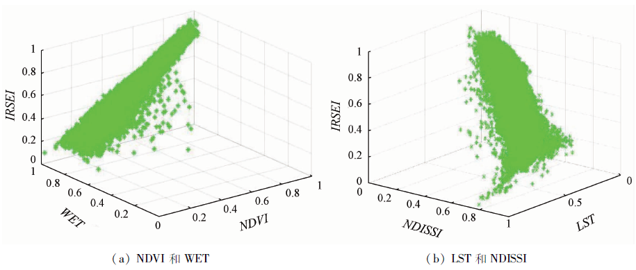
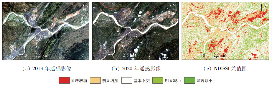
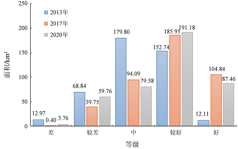
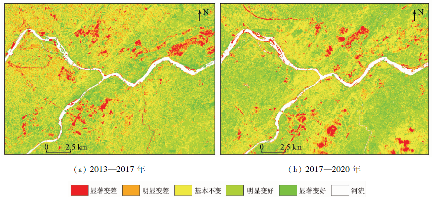
Abstract Urban expansion is the main characteristic of Yibin City in recent years, and the study of its impacts on ecology is significant for urban development and ecological protection. To assess the impacts of urban expansion on the ecology more accurately, this study established an improved remote sensing ecological index (IRSEI) by using the impervious surface area index as the dryness index to replace the original building index. The IRSEI coupled the improved dryness index and the indices greatly influencing the ecology, such as greenness, humidity, and temperature. This study analyzed the IRSEI using principal component analysis and correlation and established an IRSEI-based ecological assessment model of the three-river (i.e., the Jinsha River, Minjiang River, and Yangtze River) confluence in Yibin City. Then, this study analyzed and assessed the ecological environment of the confluence in 2013—2020. The results are as follows. The IRSEI can more accurately reflect the negative impacts of the dryness index on the ecology of the confluence. It can concentrate more useful information in the first principal component than the RSEI and can better apply to the quality assessment of urban ecological environment. In 2013, the IRSEI of the confluence was 0.54, indicating the moderate ecological status overall. The reason is that the original vegetation was destroyed by serious urban expansion. In 2017, the IRSEI was 0.67. The greenness was significantly improved by the continuous advancement of returning farmland to forests and the restoration of urban ecology, which is the reason that the ecology has greatly improved in 2017 compared to 2013. In 2020, the IRSEI was 0.63. The greenness, humidity, and dryness in 2020 were roughly the same as those in 2013, while the temperature rose in 2020 compared to 2017 due to the heat island effect induced by urban expansion. This is the reason for the slight decline in the ecological level in 2020.
|
| Keywords
improved remote sensing ecological index (IRSEI)
principal component analysis
correlation
three-river confluence in Yibin City
ecological assessment
|
|
|
|
Corresponding Authors:
ZHAO Liangjun
E-mail: 1029765315@qq.com;149189602@qq.com
|
|
Issue Date: 14 March 2022
|
|
|
| [1] |
Pauleit S, Ennos R, Golding Y. Modeling the environmental impacts of urban land use and land cover change:A study in Merseyside,UK[J]. Landscape and Urban Planning, 2005, 71(2-4):295-310.
doi: 10.1016/S0169-2046(04)00083-0
url: https://linkinghub.elsevier.com/retrieve/pii/S0169204604000830
|
| [2] |
Musse M A, Barona D A, Rodriguez L M S. Urban environmental quality assessment using remote sensing and census data[J]. International Journal of Applied Earth Observation and Geoinformation, 2018, 71(71):95-108.
doi: 10.1016/j.jag.2018.05.010
url: https://linkinghub.elsevier.com/retrieve/pii/S030324341830463X
|
| [3] |
王瑶, 宫辉力, 李小娟. 基于GIS的北京市生态环境质量监测与分析[J]. 自然资源遥感, 2008, 20(1):94-99.doi: 10.6046/gtzyyg.2008.01.21.
doi: 10.6046/gtzyyg.2008.01.21
|
| [3] |
Wang Y, Gong H L, Li X J. The monitoring and analysis of ecological environment quality of Beijing based on GIS[J]. Remote Sensing for Land and Resources, 2008, 20(1):94-99.doi: 10.6046/gtzyyg.2008.01.21.
doi: 10.6046/gtzyyg.2008.01.21
|
| [4] |
徐涵秋. 城市遥感生态指数的创建及其应用[J]. 生态学报, 2013, 33(24):7853-7862.
|
| [4] |
Xu H Q, A remote sensing urban ecological index and its application[J]. Acta Ecologica Sinica, 2013, 33(24):7853-7862.
|
| [5] |
徐志刚, 郑鸿瑞, 戴晨曦, 等. 永定客家土楼世界遗产地土地覆盖与生态变化遥感评价[J]. 自然资源遥感, 2018, 30(1):102-108.doi: 10.6046/gtzyyg.2018.01.14.
doi: 10.6046/gtzyyg.2018.01.14
|
| [5] |
Xu Z G, Zheng H R, Dai C X, et al. Evaluation of land cover and ecological change of Yongding Hakka Tulou World Heritage Protection Area using remote sensing image[J]. Remote Sensing for Land and Resources, 2018, 30(1):102-108.doi: 10.6046/gtzyyg.2018.01.14.
doi: 10.6046/gtzyyg.2018.01.14
|
| [6] |
木哈代思·艾日肯, 张飞, 刘康, 等. 基于天宫二号及Landsat8城镇生态环境现状评价[J]. 自然资源遥感, 2020, 32(4):209-218.doi: 10.6046/gtzyyg.2020.04.26.
doi: 10.6046/gtzyyg.2020.04.26
|
| [6] |
Muhadaisi A, Zhang F, Liu K, et al. Urban ecological environment evaluation based on Tiangong-2 and Landsat8 data[J]. Remote Sensing for Land and Resources, 2020, 32(4):209-218.doi: 10.6046/gtzyyg.2020.04.26.
doi: 10.6046/gtzyyg.2020.04.26
|
| [7] |
罗春, 刘辉, 戚陆越. 基于遥感指数的生态变化评估——以常宁市为例[J]. 自然资源遥感, 2014, 26(4):145-150.doi: 10.6046/gtzyyg.2014.04.23.
doi: 10.6046/gtzyyg.2014.04.23
|
| [7] |
Luo C, Liu H, Qi L Y. Ecological changes assessment based on remote sensing indices: A case study of Changning City[J]. Remote Sensing for Land and Resources, 2014, 26(4):145-150.doi: 10.6046/gtzyyg.2014.04.23.
doi: 10.6046/gtzyyg.2014.04.23
|
| [8] |
Xu H. A new index for delineating built-up land features in satellite imagery[J]. International Journal of Remote Sensing, 2008, 29(14):4269-4276.
doi: 10.1080/01431160802039957
url: https://www.tandfonline.com/doi/full/10.1080/01431160802039957
|
| [9] |
徐涵秋. 一种基于指数的新型遥感建筑用地指数及其生态环境意义[J]. 遥感技术与应用, 2007, 22(3):301-308.
|
| [9] |
Xu H Q. A new index-based built-up index(IBI) and its eco-environmental significance[J]. Remote Sensing Technology and Application, 2007, 22(3):301-308.
|
| [10] |
Xu H Q. Analysis of impervious surface and its impact on urban heat environment using the normalized difference impervious surface index(NDISI)[J]. Photogrammetric Engineering and Remote Sensing, 2010, 76(5):557-565.
doi: 10.14358/PERS.76.5.557
url: http://openurl.ingenta.com/content/xref?genre=article&issn=0099-1112&volume=76&issue=5&spage=557
|
| [11] |
Rikimaru A, Roy P S, Miyatake S. Tropical forest cover density mapping[J]. Tropical Ecology, 2002, 43(1):39-47.
|
| [12] |
Xu H Q. Modification of normalised difference water index (NDWI) to enhance open water features in remotely sensed imagery[J]. International Journal of Remote Sensing, 2006, 27(12/14):3025-3033.
doi: 10.1080/01431160600589179
url: https://www.tandfonline.com/doi/full/10.1080/01431160600589179
|
| [13] |
程志峰, 何祺胜. 基于RSEI的苏锡常城市群生态环境遥感评价[J]. 遥感技术与应用, 2019, 34(3):531-539.
|
| [13] |
Cheng Z F, He Q S. Remote sensing evaluation of the ecological environment of Su-Xi-Chang city group based on remote sensing ecological index (RSEI)[J]. Remote Sensing Technology and Application, 2019, 34(3):531-539.
|
| [14] |
Chander G, Markham B. Revised Landsat-5 TM radiometric calibration procedures and post calibration dynamic ranges[J]. IEEE Transactions on Geoscience and Remote Sensing, 2003, 41(11):2674-2677.
doi: 10.1109/TGRS.2003.818464
url: http://ieeexplore.ieee.org/document/1245255/
|
| [15] |
覃志豪, 李文娟, 徐斌, 等. 2004, 陆地卫星TM6波段范围内地表比辐射率的估计[J]. 自然资源遥感, 16(3):28-32, 36,41.doi: 10.6046/gtzyyg.2004.03.07.
doi: 10.6046/gtzyyg.2004.03.07
|
| [15] |
Qin Z H, Li W J, Xu B, et al. The estimation of land surface emissivity for Landsat TM6[J]. Remote Sensing for Land and Resources, 2004, 16(3):28-32,36,41.doi: 10.6046/gtzyyg.2004.03.07.
doi: 10.6046/gtzyyg.2004.03.07
|
| [16] |
杨永健. 基于遥感生态指数的生态质量变化分析[D]. 西安:长安大学, 2019.
|
| [16] |
Yang Y J. Ecological quality assessment based on remote sensing ecological index:A case study of Fujian Province[D]. Xi’an:Chang’an University, 2019.
|
| [17] |
Zha Y, Gao J, Ni S. Use of normalized difference built-up index in automatically mapping urban areas from TM imagery[J]. International Journal of Remote Sensing, 2003, 24(3):583-594.
doi: 10.1080/01431160304987
url: https://www.tandfonline.com/doi/full/10.1080/01431160304987
|
| [18] |
徐涵秋, 王美雅. 地表不透水面信息遥感的主要方法分析[J]. 遥感学报, 2016, 20(5):1270-1289.
|
| [18] |
Xu H Q, Wang M Y. Remote sensing-based retrieval of ground impervious surfaces[J]. Journal of Remote Sensing, 2016, 20(5):1270-1289.
|
| [19] |
刘畅, 杨康, 程亮, 等. Landsat8不透水面遥感信息提取方法对比[J]. 自然资源遥感, 2019, 31(3):148-156.doi: 10.6046/gtzyyg.2019.03.19.
doi: 10.6046/gtzyyg.2019.03.19
|
| [19] |
Liu C, Yang K, Cheng L, et al. Comparison of Landsat8 impervious surface extraction methods[J]. Remote Sensing for Land and Resources, 2019, 31(3):148-156.doi: 10.6046/gtzyyg.2019.03.19.
doi: 10.6046/gtzyyg.2019.03.19
|
| [20] |
林冬凤, 徐涵秋. 厦门城市不透水面及其热环境效应的遥感分析[J]. 亚热带资源与环境学报, 2013, 8(3):78-84.
|
| [20] |
Lin D F, Xu H Q. Urban impervious surface and its effects on thermal environments in Xiamen:An analysis based on remote sensing technology[J]. Journal of Subtropical Resources and Environment, 2013, 8(3):78-84.
|
|
Viewed |
|
|
|
Full text
|
|
|
|
|
Abstract
|
|
|
|
|
Cited |
|
|
|
|
| |
Shared |
|
|
|
|
| |
Discussed |
|
|
|
|
 2022,
Vol. 34
2022,
Vol. 34