|
|
 |
|

|
|
|
Time-series InSAR-based dynamic remote sensing monitoring of the Great Wall of the Ming Dynasty in Qinhuangdao |
LIU Hui1,2,3( ), XU Xinyue1,2,3(), CHEN Mi1,2,3, CHEN Fulong4, DING Ruili1,2,3, LIU Fei1,2,3 ), XU Xinyue1,2,3(), CHEN Mi1,2,3, CHEN Fulong4, DING Ruili1,2,3, LIU Fei1,2,3 |
1. College of Resource Environment and Tourism, Capital Normal University, Beijing 100048, China
2. State Key Laboratory of Urban Environmental Process and Digital Simulation, Capital Normal University, Beijing 100048, China
3. Beijing Laboratory of Water Resources Security, Capital Normal University, Beijing 100048, China
4. Aerospace Information Research Institute, Chinese Academy of Sciences, Beijing 100094, China |
|
|
|
|
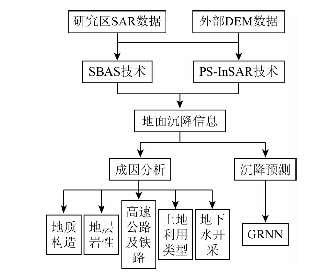
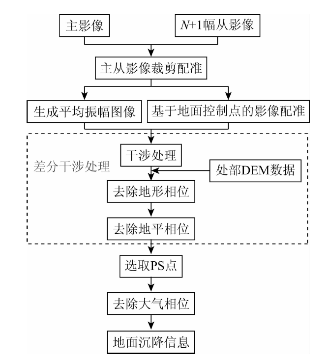
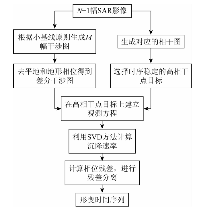
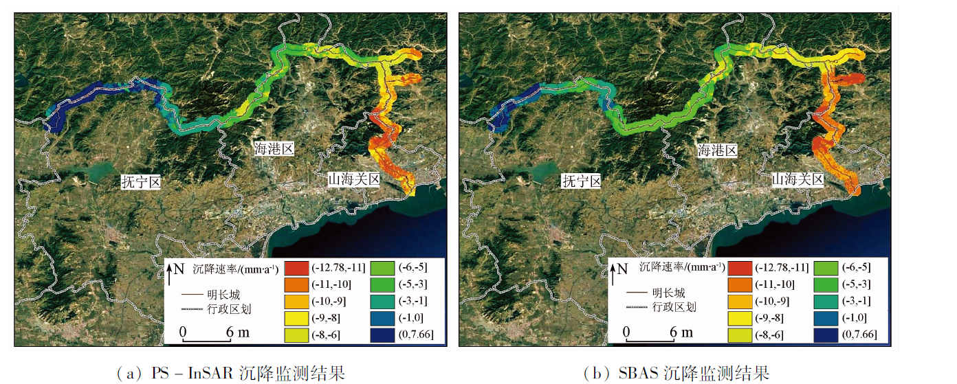
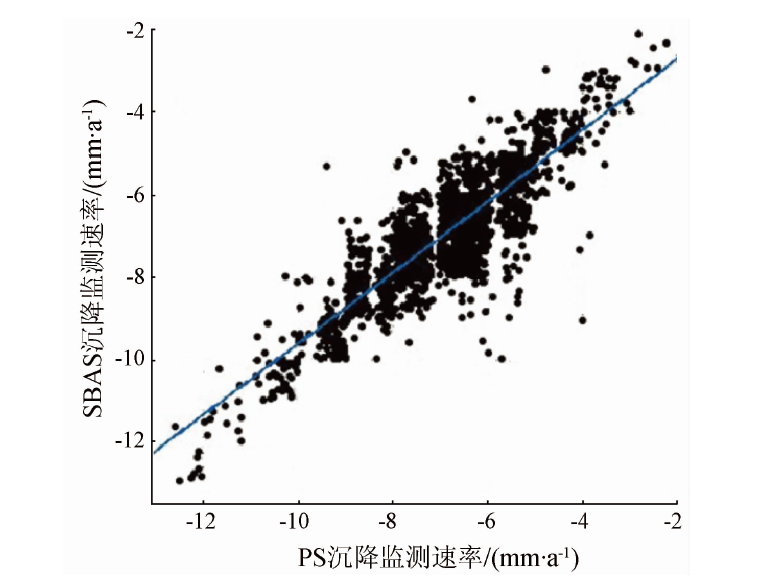
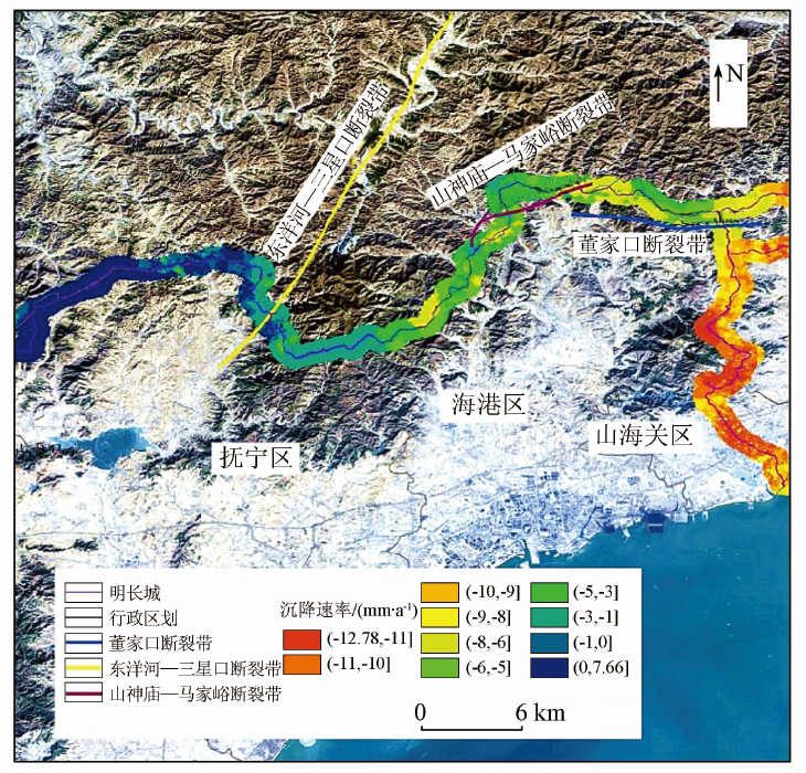
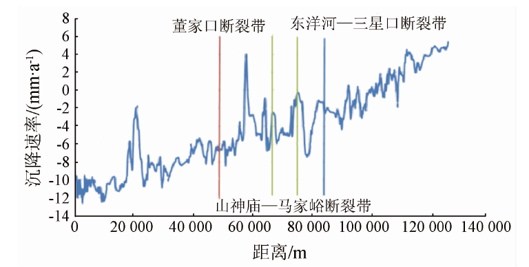
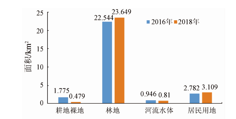
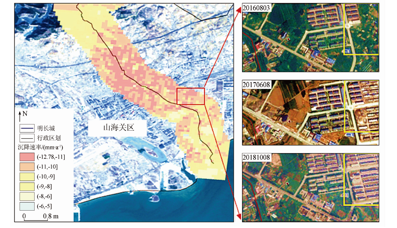
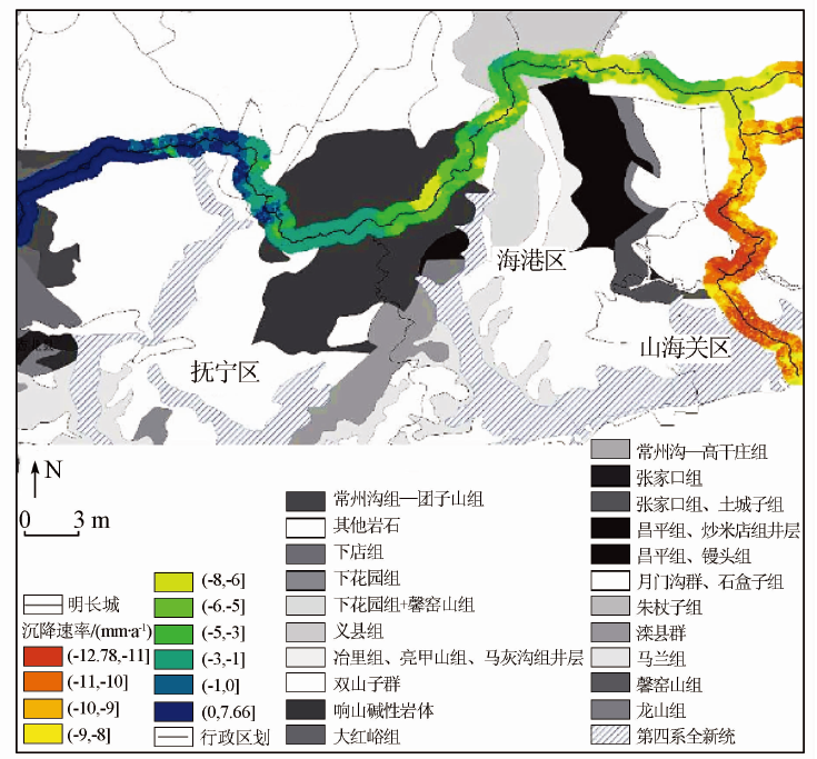
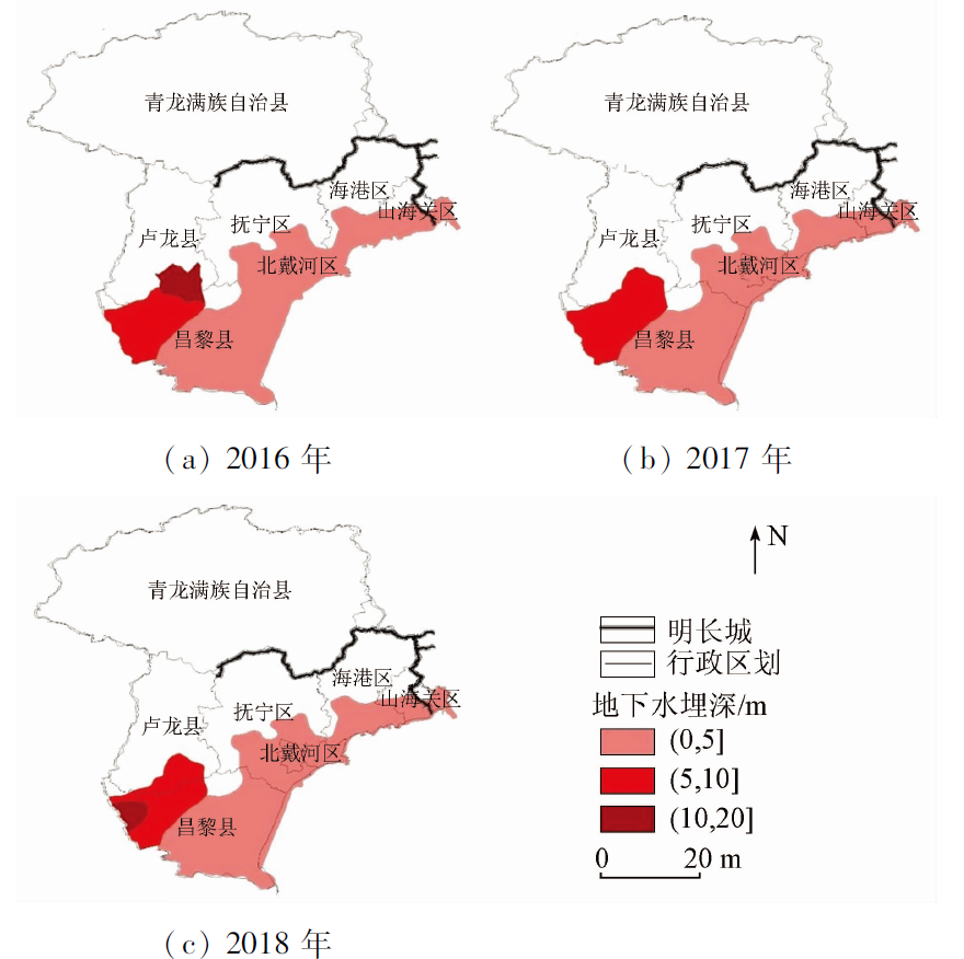
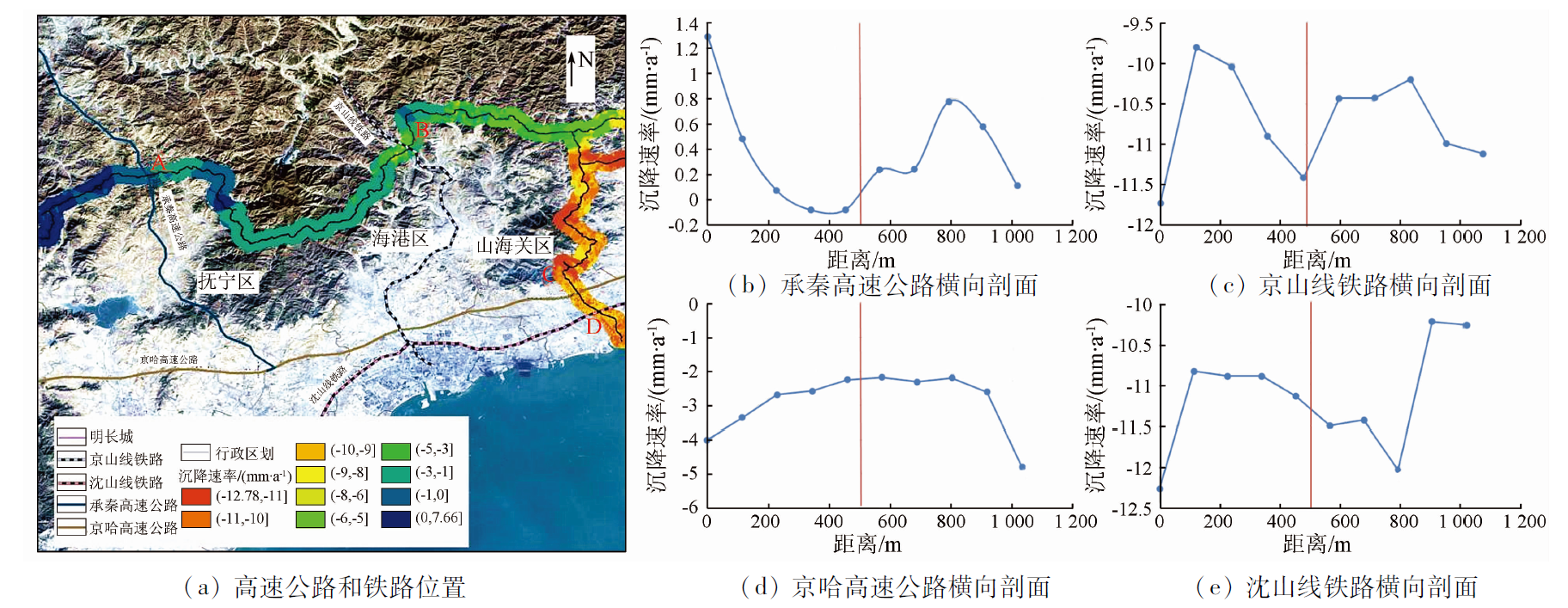
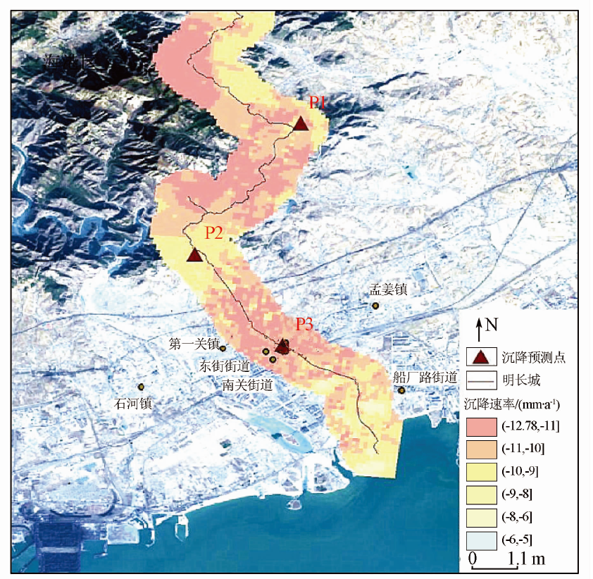
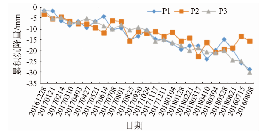
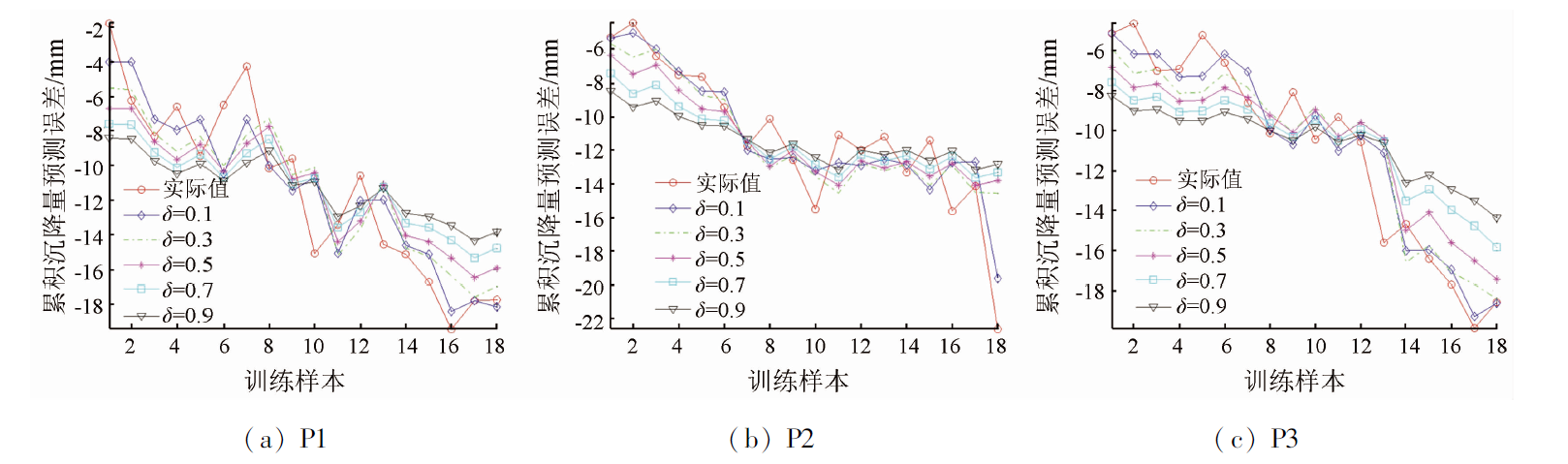
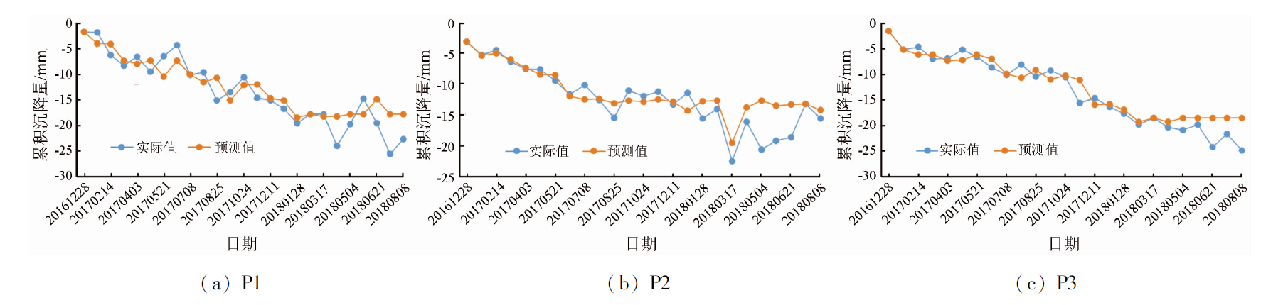
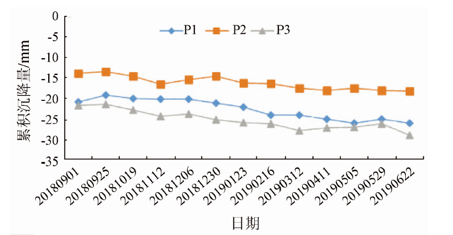
Abstract Land subsidence is a common geological disaster in the Beijing-Tianjin-Hebei region. The uneven land subsidence poses a potential threat to the protection of the Great Wall of the Ming Dynasty (the Ming Great Wall), thus causing irreversible losses. This study acquired information about the surface deformation of the Qinhuangdao section of the Ming Great Wall from 53 scenes of the Sentinel-1 data during 2016—2018 using the persistent scatterer interferometric synthetic aperture Radar (PS-InSAR) and the small baseline subsets (SBAS). The accuracy of the monitoring results was determined by the cross-validation of the deformation results obtained using different processing methods based on synthetic aperture Radar (SAR) data, yielding linear correlation with a coefficient of determination R2 of 0.81 between the two types of data. Then, this study analyzed the causes of the land subsidence along the Ming Great Wall based on auxiliary data, such as changes in the groundwater level, geological structures, stratigraphic lithology, land use, and the distribution of highways and railways. Finally, the land subsidence of the Ming Great Wall was predicted using the generalized regression neural network (GRNN). The results are as follows: ① The Qinhuangdao section of the Ming Great Wall exhibits varying degrees of deformation, with the severe deformation primarily distributed in the eastern and northeastern regions and a maximum subsidence rate of more than -12 mm/a; ② The land subsidence is slightly related to groundwater exploitation; ③ The land subsidence rate of the Ming Great Wall differ slightly before and after the great wall encounters the fault zone; ④ The areas with severe land subsidence are mainly distributed in the Quaternary Holocene clay layer; ⑤ Traffic road operation has not caused any great impact on the settlement along the Ming Great Wall. The GRNN-based prediction results show that the land subsidence along the Ming Great Wall will gradually increase in the future, and special attention should be paid to some areas. This study will provide technical support for the systematic monitoring and overall protection of the sections of the Ming Great Wall located in mountainous areas.
|
| Keywords
Great Wall of the Ming Dynasty
surface deformation
time-series InSAR
GRNN
subsidence prediction
|
|
|
|
Issue Date: 07 July 2023
|
|
|
| [1] |
Tarchi D, Rudolf H, Pieraccini M, et al. Remote monitoring of buildings using a ground-based SAR:Application to cultural heritage survey[J]. International Journal of Remote Sensing, 2000, 21(18):3545-3551.
doi: 10.1080/014311600750037561
url: https://www.tandfonline.com/doi/full/10.1080/014311600750037561
|
| [2] |
Tapete D, Cigna F. InSAR data for geohazard assessment in UNESCO World Heritage sites:State-of-the-art and perspectives in the Copernicus era[J]. International Journal of Applied Earth Observation and Geoinformation, 2017, 63:24-32.
doi: 10.1016/j.jag.2017.07.007
url: https://linkinghub.elsevier.com/retrieve/pii/S0303243417301460
|
| [3] |
何海英, 陈彩芬, 陈富龙, 等. 张家口明长城景观廊道Sentinel-1影像SBAS形变监测示范研究[J]. 国土资源遥感, 2021, 33(1):205-213.doi:10.6046/gtzyyg.2020107.
doi: 10.6046/gtzyyg.2020107
|
| [3] |
He H Y, Chen C F, Chen F L, et al. Deformation monitoring along the landscape corridor of Zhangjiakou Ming Great Wall using Sent inel-1 SBAS-InSAR approach[J]. Remote Sensing for Land and Resources, 2021, 33(1):205-213.doi:10.6046/gtzyyg.2020107.
doi: 10.6046/gtzyyg.2020107
|
| [4] |
Chen F L, Guo H D, Ma P F, et al. Radar interferometry offers new insights into threats to the Angkor site[J]. Science Advances, 2017, 3(3):e1601284.
doi: 10.1126/sciadv.1601284
url: https://www.science.org/doi/10.1126/sciadv.1601284
|
| [5] |
Tang P, Chen F L, Zhu X K, et al. Monitoring cultural heritage sites with advanced multi-temporal InSAR technique:The case study of the summer palace[J]. Remote Sensing, 2016, 8(5):432.
doi: 10.3390/rs8050432
url: http://www.mdpi.com/2072-4292/8/5/432
|
| [6] |
Zhou W, Chen F L, Guo H D. Differential Radar interferometry for structural and ground deformation monitoring:A new tool for the conservation and sustainability of cultural heritage sites[J]. Sustainability, 2015, 7(2):1712-1729.
doi: 10.3390/su7021712
url: http://www.mdpi.com/2071-1050/7/2/1712
|
| [7] |
周玉营, 陈蜜, 宫辉力, 等. 基于时序InSAR的京津高铁北京段地面沉降监测[J]. 地球信息科学学报, 2017, 19(10):1393-1403.
doi: 10.3724/SP.J.1047.2017.01393
|
| [7] |
Zhou Y Y, Chen M, Gong H L, et al. The subsidence monitoring of Beijing-Tianjin high-speed railway based on PS-InSAR[J]. Journal of Geo-Information Science, 2017, 19(10):1393-1403.
|
| [8] |
Berardino P, Fornaro G, La N R, et al. A new algorithm for surface deformation based on small baseline differential SAR interferograms[J]. IEEE Transactions on Geoscience and Remote Sensing, 2002, 11(40):2375-2383.
|
| [9] |
王艳, 葛大庆, 张玲, 等. 升降轨PS InSAR地面沉降监测结果的互检验与时序融[J]. 国土资源遥感, 2014, 26(4):125-130.doi:10.6046/gtzyyg.2014.04.20.
doi: 10.6046/gtzyyg.2014.04.20
|
| [9] |
Wang Y, Ge D Q, Zhang L, et al. Inter-comparison and time series fusion of ascending and descending PS InSAR data for land subsidence monitoring[J]. Remote Sensing for Land and Resources, 2014, 26(4):125-130.doi:10.6046/gtzyyg.2014.04.20.
doi: 10.6046/gtzyyg.2014.04.20
|
| [10] |
郝文辉, 苏凯, 郭巨, 等. 秦皇岛市地质灾害现状特征及防治体系建设探讨[J]. 地下水, 2016, 38(5):176-178.
|
| [10] |
Hao W H, Su K, Guo J, et al. Geo-hazard current situation and prevention construction system in Qinhuangdao City[J]. Ground Water, 2016, 38(5):176-178.
|
| [11] |
廖东, 戴洪宝, 许继影. 基于Landsat8监督分类与非监督分类的土地利用分类方法比较[J]. 河南科技, 2019(8):14-16.
|
| [11] |
Liao D, Dai H B, Xu J Y. Comparison of land use classification methods based on Landsat8 supervised classification and unsupervised classification[J]. Henan Science and Technology, 2019(8):14-16.
|
| [12] |
祝秀星, 陈蜜, 宫辉力, 等. 采用时序InSAR技术监测北京地铁网络沿线地面沉降[J]. 地球信息科学学报, 2018, 20(12):1810-1819.
doi: 10.12082/dqxxkx.2018.180322
|
| [12] |
Zhu X X, Chen M, Gong H L, et al. The subsidence monitoring along Beijing subway network based on MT-InSAR[J]. Journal of Geo-Information Science, 2018, 20(12):1810-1819.
|
| [13] |
金帅军. 基于GRNN神经网络的农作物虫害量预测系统设计[D]. 呼和浩特: 内蒙古工业大学, 2013.
|
| [13] |
Jin S J. Design the prediction of system insect pests of crop based on GRNN neural network[D]. Huhhot: Inner Mongolia University of Technology, 2013.
|
| [14] |
曹波, 罗飞, 许玉格. 基于GRNN的污水出水水质预测模型[J]. 环境卫生工程, 2011, 19(6):1-3.
|
| [14] |
Cao B, Luo F, Xu Y G. A prediction model based on GRNN for sewage discharge quality[J]. Environmental Sanitation Engineering, 2011, 19(6):1-3.
|
| [15] |
魏晋雁, 茹锋. 采用GRNN模型进行交通量预测及实现研究[J]. 长沙交通学院学报, 2006(2):46-50.
|
| [15] |
Wei J Y, Ru F. Forecasting the traffic volume by the model of GRNN and studing it’s realization[J]. Journal of Changsha Communications University, 2006(2):46-50.
|
|
Viewed |
|
|
|
Full text
|
|
|
|
|
Abstract
|
|
|
|
|
Cited |
|
|
|
|
| |
Shared |
|
|
|
|
| |
Discussed |
|
|
|
|
 2023,
Vol. 35
2023,
Vol. 35