Please wait a minute...
 
Remote Sensing for Land & Resources    2020, Vol. 32 Issue (3) : 114-120     DOI: 10.6046/gtzyyg.2020.03.15
|
Detecting tiny differential deformation of Tangshan urban active fault using multi-source SAR data
ZHANG Ling(), LIU Bin, GE Daqing, GUO Xiaofang
China Aero Geophysical Survey and Remote Sensing Center for Natural Resources, Beijing 100083, China
Download: PDF(4024 KB)   HTML
Export: BibTeX | EndNote | Reference Manager | ProCite | RefWorks    
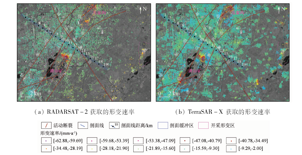
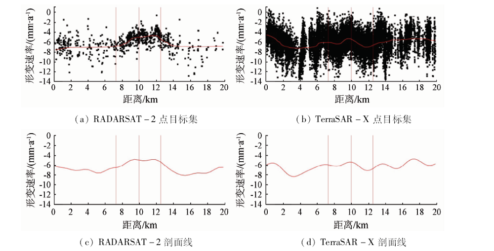
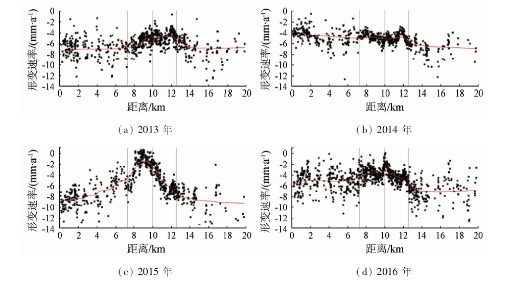
Abstract  

The active faults deformation, with distinct temporal and spatial variations, requires long-term and effective monitoring. InSAR (interferometry synthetic aperture Radar), with the advantages of high efficiency, wide coverage and low cost, is one of the main technical means for ground surface deformation survey in recent years. In this paper, the small differential deformation of the main active faults in Tangshan urban area was monitored by the interferometric point target analysis. Two kinds of radar data were used: the Wide strip mode of RADARSAT-2 C-band with 30m spatial resolution and the Strip mode of TerraSAR-X X-band with 3 m spatial resolution. The results show that the differential deformation of Tangshan-Guye active fault is obvious with the maximum differential velocity of 2 mm/a. In this case, the deformation results from RADARSAT-2 C-band medium resolution data can clearly show the tiny differential deformation between the two sides of the active faults. However, TerraSAR-X X-band data, with shorter wavelength, is more obviously affected by the change of surface cover. Compared with this deformation, the vertical differential deformation between the two sides of active faults is too small to be separated from the TerraSAR results.

Keywords InSAR      active fault      differential deformation      tiny surface deformation     
:  P237  
Issue Date: 09 October 2020
Service
E-mail this article
E-mail Alert
RSS
Articles by authors
Ling ZHANG
Bin LIU
Daqing GE
Xiaofang GUO
Cite this article:   
Ling ZHANG,Bin LIU,Daqing GE, et al. Detecting tiny differential deformation of Tangshan urban active fault using multi-source SAR data[J]. Remote Sensing for Land & Resources, 2020, 32(3): 114-120.
URL:  
https://www.gtzyyg.com/EN/10.6046/gtzyyg.2020.03.15     OR     https://www.gtzyyg.com/EN/Y2020/V32/I3/114
测量值 精度(1σ)
平均形变速率(LOS)/(mm·a-1) 1
单次差分测量(LOS)/mm 5
东向/m 6
北向/m 3
高程/m 1.5
Tab.1  Typical values of precision
Fig.1  Data processing chart
编号 日期 编号 日期 编号 日期 编号 日期
1 2012/11/18 10 2013/11/13 19 2014/12/02 28 2016/03/26
2 2013/01/05 11 2013/12/07 20 2014/12/26 29 2016/04/19
3 2013/01/29 12 2014/02/17 21 2015/02/12 30 2016/05/13
4 2013/04/11 13 2014/04/06 22 2015/04/01 31 2016/06/06
5 2013/05/05 14 2014/04/30 23 2015/05/19 32 2016/06/30
6 2013/06/22 15 2014/08/04 24 2015/07/30 33 2016/08/17
7 2013/08/09 16 2014/08/28 25 2015/08/23 34 2016/09/10
8 2013/09/02 17 2014/09/21 26 2015/10/10 35 2016/10/28
9 2013/09/26 18 2014/11/08 27 2016/02/07
Tab.2  Data list of RADARSAT-2
编号 日期 编号 日期 编号 日期 编号 日期
1 2012/12/06 4 2013/04/28 7 2013/09/29 10 2013/12/04
2 2013/02/10 5 2013/06/11 8 2013/10/21 11 2013/12/26
3 2013/03/15 6 2013/08/27 9 2013/11/12
Tab.3  Data list of TerraSAR-X
Fig.2  Baseline graph of interferometric images combination
Fig.3  Subsidence velocity map of Tangshan urban area in 2013
Fig.4  Comparison of different profile data in 2013
Fig.5  Tiny differential deformation of active fault in the study area from 2013 to 2016
[1] Fialko Y. Interseismic strain accumulation and the earthquake potential on the southern San Andreas Fault system[J]. Nature, 2006,441(22):967-971.
[2] 屈春燕, 单新建, 张国宏, 等. 时序InSAR断层活动性观测研究进展及若干问题探讨[J]. 地震地质, 2014,36(3):731-748.
doi: 10.3969/j.issn.0253-4967.2014.03.015 url: http://www.dz-dz.com.cn/CN/abstract/abstract10901.shtml
[2] Qu C Y, Shan X J, Zhang G H, et al. The research progress in measurement of fault activity by time series InSAR and discussion of related issues[J]. Seismology and Geology, 2014,36(3):731-748.
doi: 10.3969/j.issn.0253-4967.2014.03.015 url: http://www.dz-dz.com.cn/CN/abstract/abstract10901.shtml
[3] Zhang L, Cao D Y, Zhang J F, et al. Interseismic fault movement of Xianshuihe fault zone based on across-fault deformation data and InSAR[J].Pure and Applied Geophysics, 2019(176):649-667.
[4] 周海涛, 郭良迁, 张立成. 唐山断裂现代活动性研究[J]. 华北地震科学, 2009,27(3):17-22.
[4] Zhou H T, Guo L Q, Zhang L C. Study on modern activity of Tangshan fault[J]. North China Earthquake Sciences, 2009,27(3):17-22.
[5] Ferretti A, Prati C, Rocca F. Permanent scatterers in SAR interferometry[J]. IEEE Transactions on Geoscience and Remote Sensing, 2001,39(1):1-20.
[6] Wemer C, Wegmiiller U, Strozzi T, et al. Interferometric point target analysis for deformation mapping[J].IEEE Transactions on Geoscience and Remote Sensing, 2003(7):4362-4364.
[7] Ferretti A, Tamburini A, Novali F, et al. Impact of high resolution radar imagery on reservoir monitoring[J]. Energy Procedia, 2011,(4):3465-3471.
doi: 10.1016/j.egypro.2011.02.272 url: http://dx.doi.org/10.1016/j.egypro.2011.02.272
[8] Berardino P, Fornaro G, Lanari R, et al. A new algorithm for surface deformation monitoring based on small baseline differential SAR interferograms[J]. IEEE Transactions on Geoscience and Remote Sensing, 2002,40(11):2375-2383.
doi: 10.1109/TGRS.2002.803792 url: http://ieeexplore.ieee.org/document/1166596/
[9] 邓起东. 城市活动断裂探测和地震危险性评价问题[J]. 地震地质, 2002,24(4):601-605.
url: http://www.dz-dz.com.cn/CN/abstract/abstract8887.shtml
[9] Deng Q D. Exploration and Seismic hazard assessment of active faults in urban areas[J]. Seismology and Geology, 2002,24(4):601-605.
url: http://www.dz-dz.com.cn/CN/abstract/abstract8887.shtml
[10] 李传友, 汪一鹏, 王志才. 中国东部城市地区隐伏断裂上断点与最新活动时代关系的初步分析——以邢台、唐山地震区为例[J]. 地震地质, 2007,29(2):431-445.
url: http://www.dz-dz.com.cn/CN/abstract/abstract8552.shtml
[10] Li C Y, Wang Y P, Wang Z C. Some analyses on the relation between the upper offset point and the latest activity times of buried faults in cities of eastern China:Taking the Xingtai and Tangshan earthquake regions as an example[J]. Seismology and Geology, 2007,29(2):431-445.
url: http://www.dz-dz.com.cn/CN/abstract/abstract8552.shtml
[11] 王景明, 王文秋, 苏幼坡. 唐山市区断裂活动与地质灾害[J]. 河北理工学院学报, 1998,20(1):75-83.
[11] Wang J M, Wang W Q, Su Y P. The fracture activities and geological calamity in Tangshan City[J]. Journal of Hebei Institute of Technology, 1998,20(1):75-83.
[12] Liu K, Qu G S, Chen J Q, et al. Recurrence characteristics of major earthquakes in the Tangshan area,north China[J]. Acta Geologica Sinica-English Edition, 2013,87(1):254-271.
doi: 10.1111/1755-6724.12046 url: http://www.geojournals.cn/dzxben/ch/reader/view_abstract.aspx?file_no=201301021&flag=1
[1] YANG Wang, HE Yi, ZHANG Lifeng, WANG Wenhui, CHEN Youdong, CHEN Yi. InSAR monitoring of 3D surface deformation in Jinchuan mining area, Gansu Province[J]. Remote Sensing for Natural Resources, 2022, 34(1): 177-188.
[2] LI Mengmeng, FAN Xueting, CHEN Chao, LI Qiannan, YANG Jin. Monitoring and interpretation of land subsidence in mining areas in Xuzhou City during 2016—2018[J]. Remote Sensing for Natural Resources, 2021, 33(4): 43-54.
[3] SHI Min, GONG Huili, CHEN Beibei, GAO Mingliang, ZHANG Shunkang. Monitoring of land subsidence in Beijing-Tianjin-Hebei plain during 2016—2018 based on InSAR and Sentinel-1A data[J]. Remote Sensing for Natural Resources, 2021, 33(4): 55-63.
[4] SHA Yonglian, WANG Xiaowen, LIU Guoxiang, ZHANG Rui, ZHANG Bo. SBAS-InSAR-based monitoring and inversion of surface subsidence of the Shadunzi Coal Mine in Hami City, Xinjiang[J]. Remote Sensing for Natural Resources, 2021, 33(3): 194-201.
[5] ZHANG Teng, XIE Shuai, HUANG Bo, FAN Jinghui, CHEN Jianping, TONG Liqiang. Detection of active landslides in central Maoxian County using Sentinel-1 and ALOS-2 data[J]. Remote Sensing for Land & Resources, 2021, 33(2): 213-219.
[6] HE Haiying, CHEN Caifen, CHEN Fulong, TANG Panpan. Deformation monitoring along the landscape corridor of Zhangjiakou Ming Great Wall using Sentinel-1 SBAS-InSAR approach[J]. Remote Sensing for Land & Resources, 2021, 33(1): 205-213.
[7] YU Hairuo, GONG Huili, CHEN Beibei, ZHOU Chaofan. Emerging risks and the prospect of urban underground space security based on InSAR-GRACE satellite under the new hydrological background[J]. Remote Sensing for Land & Resources, 2020, 32(4): 16-22.
[8] Mao ZHU, Tiyan SHEN, Song HUANG, Shujian BAI, Chunqin GE, Qiong HU. Research on applications of InSAR technology to the deformation monitoring of buildings along the subway[J]. Remote Sensing for Land & Resources, 2019, 31(2): 196-203.
[9] Zhenlin WANG, Mingsheng LIAO, Lu ZHANG, Heng LUO, Jie DONG. Detecting and characterizing deformations of the left bank slope near the Jinping hydropower station with time series Sentinel-1 data[J]. Remote Sensing for Land & Resources, 2019, 31(2): 204-209.
[10] Zechao BAI, Baocun WANG, Guowang JIN, Qing XU, Hongmin ZHANG, Hui LIU. Applicability analysis of ground deformation monitoring in mining area by Sentinel - 1A data[J]. Remote Sensing for Land & Resources, 2019, 31(2): 210-217.
[11] Dong WANG, Fengbing LAI, Mengyu CHEN, Shujiang CHEN, Tiecheng HUANG, Xiang JIA. Research on coseismic deformation in Ukraine River Valley of Tianshan Mountains based on InSAR technology[J]. Remote Sensing for Land & Resources, 2019, 31(1): 187-194.
[12] Xiaoping XIE, Maowei BAI, Zhicong CHEN, Weibo LIU, Shuna XI. Remote sensing image interpretation and tectonic activity study of the active faults along the northeastern segment of the Longmenshan fault[J]. Remote Sensing for Land & Resources, 2019, 31(1): 237-246.
[13] Nianqin WANG, Dejing QIAO, Xiyou FU. An analysis of the influence of filtering parameter on the performance of Goldstein InSAR interfergram filter[J]. Remote Sensing for Land & Resources, 2019, 31(1): 117-124.
[14] Juan XUE, Linfeng YU, Qinan LIN, Guang LIU, Huaguo HUANG. Using Sentinel-1 multi-temporal InSAR data to monitor the damage degree of shoot beetle in Yunnan pine forest[J]. Remote Sensing for Land & Resources, 2018, 30(4): 108-114.
[15] Yangming WANG, Jingfa ZHANG, Zhirong LIU, Xuhui SHEN. Active faults interpretation of Shannan area in Tibet based on multi-source remote sensing data[J]. Remote Sensing for Land & Resources, 2018, 30(3): 230-237.
Viewed
Full text


Abstract

Cited

  Shared   
  Discussed   
京ICP备05055290号-2
Copyright © 2017 Remote Sensing for Natural Resources
Support by Beijing Magtech