|
|
 |
|

|
|
|
Spatiotemporal analysis of drought in sugarcane planting areas of Guangxi by remote sensing |
QIN Wen1,2( ), HUANG Qiuyan1,3(), QIN Zhihao4, LIU Jianhong1, WEI Gaoyang1 ), HUANG Qiuyan1,3(), QIN Zhihao4, LIU Jianhong1, WEI Gaoyang1 |
1. School of Geography Science and Planning, Nanning Normal University, Nanning 530001, China
2. Scientific Research Academy of Guangxi Environmental Protection, Nanning 530022, China
3. Key Laboratory of Environmental Evolution and Resource Utilization of Beibu Gulf, Nanning Normal University, Nanning 530001, China
4. Institute of Agricultural Resources and Regional Planning, Chinese Academy of Agricultural Sciences, Beijing 100081, China |
|
|
|
|
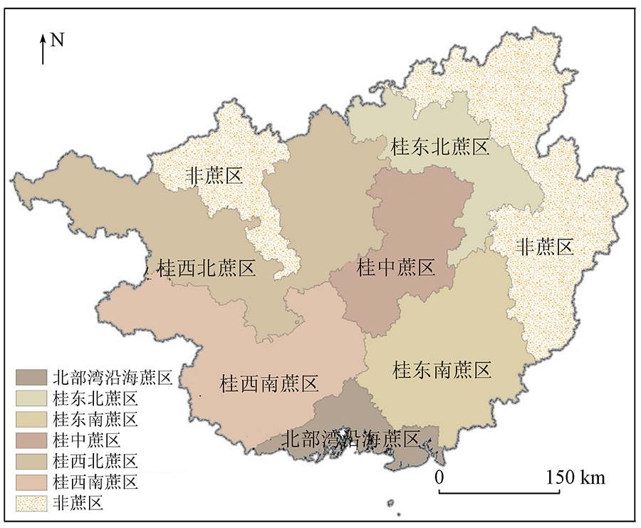
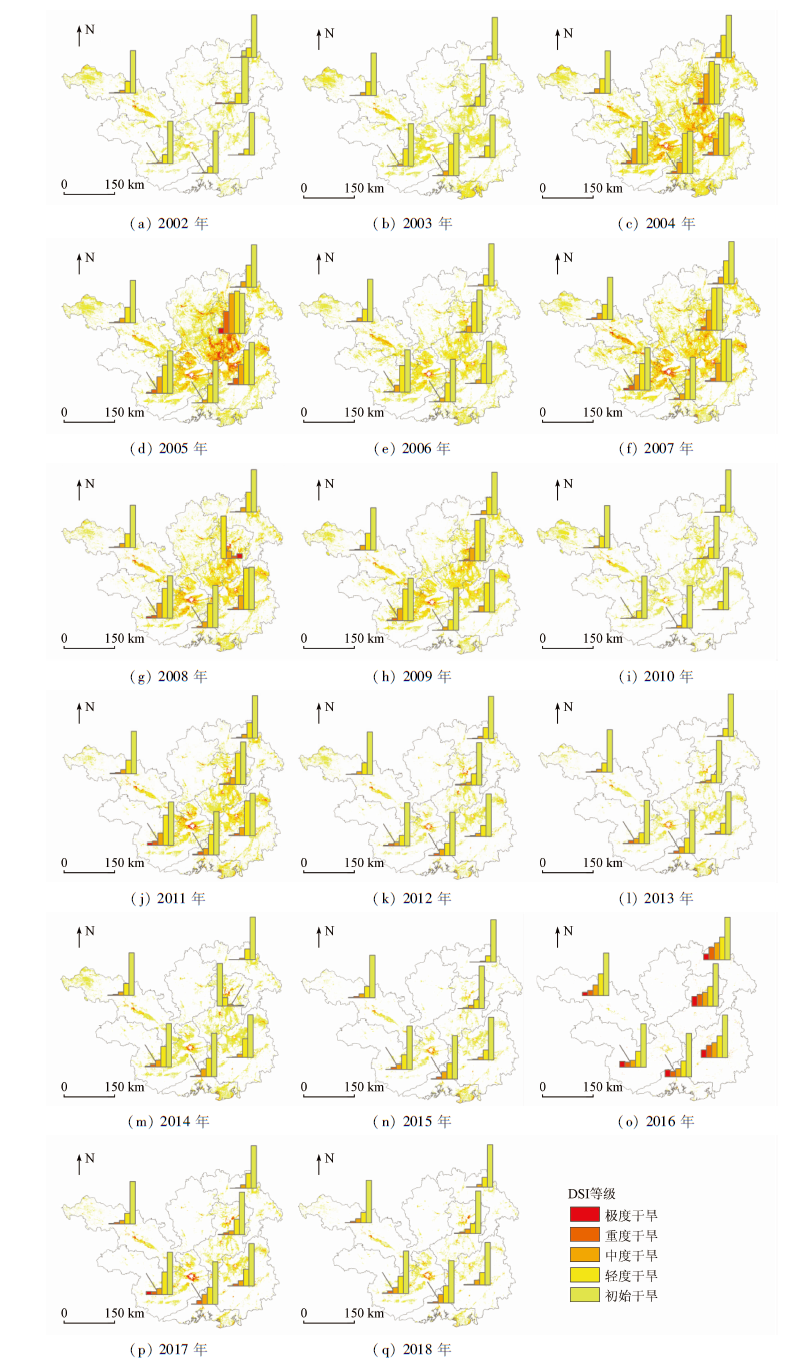
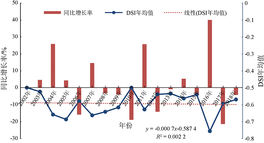
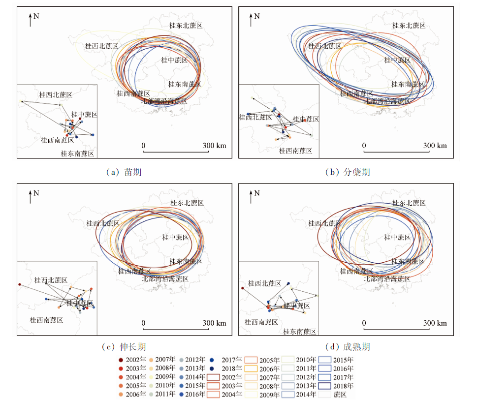
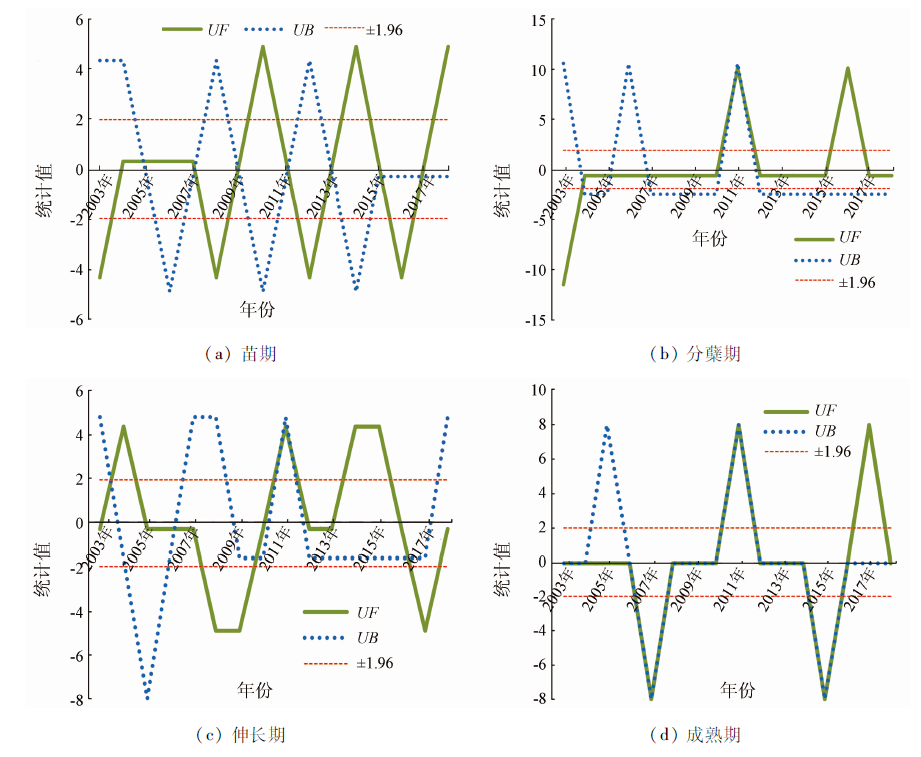
Abstract Guangxi is the most important sugarcane producing area in China. Remote sensing of drought in sugarcane planting areas is of great practical significance to decision-making for the anti-drought campaign in Guangxi where sugarcane planting is mainly on the farmland without irrigation guarantee. This study intends to examine the issue of remote sensing monitoring of drought in sugarcane planning areas in Guangxi. MODIS data product MOD16/MYD16 was used to calculate the drought intensity index (DSI) in Guangxi sugarcane planting areas for a period from 2002 to 2018. On the basis of this calculation, the spatiotemporal characteristics of different drought grades in Guangxi sugarcane planting areas were analyzed. In order to reveal the changing trend of the drought severity in the sugarcane planning areas, three methods, i.e. unary linear regression, Mann-Kendall trend test and Hurst index, were used in the study to analyze the change trend of drought in the sugarcane planting areas of Guangxi. The results showed that the drought in Guangxi during the period from 2002 to 2018 mainly happened in the center, the southeast, the southwest, and the northwest sugarcane areas. The annual average of DSI was -0.59 during the period. Very high DSI was observed in two years, i.e. 2010 and 2002, implying that sugarcane planting in Guangxi experienced the most severe drought in the two years. Very low DSI was seen in 2016, indicating the minimal impact of drought on the planting areas this year. The change of DSI in the sugarcane planting areas of Guangxi showed a trend of a slight decrease from 2002 to 2018, with an annual rate of -0.07%. In terms of the spatial center of gravity of drought, the center of gravity of drought areas in different growth periods showed a trend of expansion from the center to the northwest, and the path of gravity center shift was as follows: central planting area > southwest planting area > northwest planting area. From the perspective of years, DSI in each year revealed a remarkable fluctuation during the period in question. Sharp changes in DSI might also be seen in some years, implying that drought had variability among years in Guangxi. The spatiotemporal variation of drought in Guangxi is obviously related to the climate change in the areas. Therefore we believe that sugarcane planting in Guangxi might continuously face the challenges from the frequent occurrence of the drought of various grades as a result of future climate change. Remote sensing monitoring of the drought can provide useful information on drought events and their dynamics for anti-drought campaigns to reduce the impact of drought on sugarcane planting in Guangxi.
|
| Keywords
DSI
shift of the center of gravity
spatiotemporal evolution of drought
sugarcane
|
|
|
|
Corresponding Authors:
HUANG Qiuyan
E-mail: qinw0717@foxmail.com;hqy@nnnu.edu.cn
|
|
Issue Date: 20 June 2022
|
|
|
| [1] |
区颖刚. 我国甘蔗生产全程机械化现状与对策[J]. 现代农业装备, 2019, 40(2):3-8,42.
|
| [1] |
Ou Y G. Present situation and countermeasure of whole-process mechanization of sugarcane production in China[J]. Modern Agricultural Equipment, 2019, 40(2):3-8,42.
|
| [2] |
罗晟昇, 廖韦卫, 韦海球, 等. 干旱胁迫对甘蔗生长研究进展[J]. 中国热带农业, 2020(5):70-73.
|
| [2] |
Luo S S, Liao W W, Wei H Q, et al. Research progress of drought stress on sugarcane growth[J]. China Tropical Agriculture, 2020(5):70-73.
|
| [3] |
农钢, 农明哲, 王达. 广西崇左甘蔗气象条件精细化分析初探[J]. 甘蔗糖业, 2019(1):10-15.
|
| [3] |
Nong G, Nong M Z, Wang D. Preliminary refinement analysis of meteorological conditions of Chongzuo sugarcane in Guangxi[J]. Sugar Cane Sugar Industry, 2019(1):10-15.
|
| [4] |
廖东声, 覃思静. 广西甘蔗产业生产成本核算及控制问题分析[J]. 学术论坛, 2013, 36(8):83-87,92.
|
| [4] |
Liao D S, Qin S J. Analysis of production cost accounting and control of Guangxi sugarcane industry[J]. Academic Forum, 2013, 36(8):83-87,92.
|
| [5] |
王俊霞, 朱秀芳, 刘宪锋, 等. 基于多源遥感数据的旱情评价研究——以河南省为例[J]. 国土资源遥感, 2018, 30(1):180-186.doi: 10.6046/gtzyyg.2018.01.25.
doi: 10.6046/gtzyyg.2018.01.25
|
| [5] |
Wang J X, Zhu X F, Liu X F, et al. Research on agriculture drought monitoring method of Henan Province with multi-sources data[J]. Remote Sensing for Land and Resources, 2018, 30(1):180-186.doi: 10.6046/gtzyyg.2018.01.25.
doi: 10.6046/gtzyyg.2018.01.25
|
| [6] |
屈艳萍, 吕娟, 张伟兵, 等. 中国历史极端干旱研究进展[J]. 水科学进展, 2018, 29(2):283-292.
|
| [6] |
Qu Y P, Lyu J, Zhang W B, et al. Progress in research on historical extreme drought in China[J]. Progress in Water Science, 2018, 29(2):283-292.
|
| [7] |
任立良, 沈鸿仁, 袁飞, 等. 变化环境下渭河流域水文干旱演变特征剖析[J]. 水科学进展, 2016, 27(4):492-500.
|
| [7] |
Ren L L, Shen H R, Yuan F, et al. Hydrological drought characteristics in the Weihe catchment in a changing environment[J]. Progress in Water Science, 2016, 27(4):492-500.
|
| [8] |
李新周, 刘晓东, 马柱国. 近百年来全球主要干旱区的干旱化特征分析[J]. 干旱区研究, 2004(2):97-103.
|
| [8] |
Li X Z, Liu X D, Ma Z G. Analysis on the drought characteristics in the main arid regions in the world since recent hundred-odd years[J]. Arid Zone Research, 2004(2):97-103.
|
| [9] |
莫建飞, 钟仕全, 陈燕丽, 等. 广西主要农业气象灾害监测预警系统的开发与应用[J]. 自然灾害学报, 2013, 22(2):150-157.
|
| [9] |
Mo J F, Zhong S Q, Chen Y L, et al. Development and application of a monitoring and early warning system for main agro-meteorological disasters in Guangxi Province[J]. Journal of Natural Disasters, 2013, 22(2):150-157.
|
| [10] |
匡昭敏. 广西农业干旱监测预报与农情分析业务系统V1.0[Z]. 广西壮族自治区,广西壮族自治区气象减灾研究所, 2013.
|
| [10] |
Kuang Z M. Guangxi agricultural drought monitoring and forecasting and agricultural condition analysis business system V1.0[Z]. Guangxi Zhuang Autonomous Region,Guangxi Institute of Meteorological Disaster Reduction, 2013.
|
| [11] |
中华人民共和国国家质量监督检验检疫总局与中国国家标准化管理委员会. GB/T 34809—2017糖料蔗干旱灾害等级[S]. 北京: 中国标准出版社, 2017.
|
| [11] |
The General Administration of Quality Supervision, Inspection and Quarantine of the People’s Republic of China and the National Standardization Administration of China. GB/T 34809—2017 Sugarcane drought disaster grade[S]. Beijing: China Standards Press, 2017.
|
| [12] |
莫建飞, 钟仕全, 陈燕丽, 等. 基于GIS的广西甘蔗萌芽分蘖期干旱等级空间分布[J]. 江苏农业科学, 2015, 43(3):113-115.
|
| [12] |
Mo J F, Zhong S Q, Chen Y L, et al. GIS-based spatial distribution of drought grades of sugarcane during germination and tillering stage in Guangxi[J]. Jiangsu Agricultural Sciences, 2015, 43(3):113-115.
|
| [13] |
陈燕丽, 蒙良莉, 黄肖寒, 等. 基于SPEI的广西甘蔗生育期干旱时空演变特征分析[J]. 农业工程学报, 2019, 35(14):149-158.
|
| [13] |
Chen Y L, Meng L L, Huang X H, et al. Spatial and temporal evolution characteristics of drought in Guangxi during sugarcane growth period based on SPEI[J]. Transactions of the Chinese Society of Agricultural Engineering, 2019, 35(14):149-158.
|
| [14] |
李家文, 黄维, 吴炫柯, 等. 柳州市甘蔗干旱风险区划——基于作物水分亏缺指数[J]. 中国农学通报, 2019, 35(22):96-105.
|
| [14] |
Li J W, Huang W, Wu X K, et al. Drought risk zone of sugarcane in Liuzhou based on crop water deficit index[J]. Chinese Agricultural Science Bulletin, 2019, 35(22):96-105.
|
| [15] |
陈燕丽, 黄思琦, 莫建飞, 等. 基于CLDAS数据的甘蔗干旱监测评估标准对比——以2011年广西干旱为例[J]. 干旱气象, 2020, 38(2):188-194.
|
| [15] |
Chen Y L, Huang S Q, Mo J F, et al. Comparison of drought monitoring standards of sugarcane based on CLDAS data:A case of drought in Guangxi in 2011[J]. Arid Meteorology, 2020, 38(2):188-194.
|
| [16] |
刘宪锋, 朱秀芳, 潘耀忠, 等. 农业干旱监测研究进展与展望[J]. 地理学报, 2015, 70(11):1835-1848.
doi: 10.11821/dlxb201511012
|
| [16] |
Liu X F, Zhu X F, Pan Y Z, et al. Agricultural drought monitor:Progress,challenges and prospect[J]. Acta Geographica Sinica, 2015, 70(11):1835-1848.
|
| [17] |
匡昭敏, 朱伟军, 丁美花, 等. 多源卫星数据在甘蔗干旱遥感监测中的应用[J]. 中国农业气象, 2007(1):93-96.
|
| [17] |
Kuang Z M, Zhu W J, Ding M H, et al. Application of multi-sources satellite data in monitoring sugarcane droughts[J]. China Agricultural Meteorology, 2007(1):93-96.
|
| [18] |
Wang P, Gong J, Li X W. Vegetation temperature condition index and its application for drought monitoring[C]// IEEE International Geoscience and Remote Sensing Symposium.IEEE, 2001.
|
| [19] |
温媛媛, 赵军, 王炎强, 等. 基于MOD16的山西省地表蒸散发时空变化特征分析[J]. 地理科学进展, 2020, 39(2):255-264.
doi: 10.18306/dlkxjz.2020.02.007
|
| [19] |
Wen Y Y, Zhao J, Wang Y Q, et al. Spatiotemporal variation characteristics of surface evapotranspiration in Shanxi Province based on MOD16[J]. Progress in Geographical Sciences, 2020, 39(2):255-264.
|
| [20] |
Mu Q, Zhao M, Kimball J S, et al. A remotely sensed global terrestrial drought severity index[J]. Bulletin of the American Meteorological Society, 2013, 94(1):83-98.
doi: 10.1175/BAMS-D-11-00213.1
url: https://journals.ametsoc.org/doi/10.1175/BAMS-D-11-00213.1
|
| [21] |
Haroon M A, Zhang J, Yao F. Drought monitoring and performance evaluation of MODIS-based drought severity index (DSI) over Pakistan[J]. Natural Hazards, 2016, 84(2):1349-1366.
doi: 10.1007/s11069-016-2490-y
url: http://link.springer.com/10.1007/s11069-016-2490-y
|
| [22] |
张喜成, 徐长春, 宋佳, 等. 基于遥感DSI的新疆干旱特征分析[J]. 江苏农业科学, 2020, 48(2):239-246.
|
| [22] |
Zhang X C, Xu C C, Song J, et al. Analysis of Xinjiang drought characteristics based on remote sensing DSI[J]. Jiangsu Agricultural Sciences, 2020, 48(2):239-246.
|
| [23] |
童德明, 白雲, 张莎, 等. 干旱严重程度指数(DSI)在山东省干旱遥感监测中的适用性[J]. 中国农业气象, 2020, 41(2):102-112.
|
| [23] |
Tong D M, Bai Y, Zhang S, et al. Analysis of drought characteristics in Xinjiang area based on remote sensing DSI index[J]. Chinese Agricultural Meteorology, 2020, 41(2):102-112.
|
| [24] |
张小强, 冯彬, 王云燕. 运用MODIS对我国西南地区极端干旱情况监测与评估研究——以2009—2010年遥感数据为例[J]. 环境保护科学, 2020, 46(1):135-141.
|
| [24] |
Zhang X Q, Feng B, Wang Y Y. Monitoring and evaluation of extreme drought in southwest China based the MODIS:A case study based on 2009—2010 remote sensing data[J]. Environmental Protection Science, 2020, 46(1):135-141.
|
| [25] |
余慧倩, 张强, 孙鹏, 等. 干旱强度及发生时间对华北平原五省冬小麦产量影响[J]. 地理学报, 2019, 74(1):87-102.
doi: 10.11821/dlxb201901007
|
| [25] |
Yu H Q, Zhang Q, Sun P, et al. Impacts of drought intensity and drought duration on winter wheat yield in five provinces of north China plain[J]. Acta Geographica Sinica, 2019, 74(1):87-102.
|
| [26] |
陈燕丽, 丁美花, 冯利平, 等. 广西宿根蔗生育期气象条件变化特征及其影响[J]. 气象, 2016, 42(12):1554-1559.
|
| [26] |
Chen Y L, Ding M H, Feng L P, et al. Characteristics of meteorological condition and its effects on ratoon sugarcane in different stages in Guangxi[J]. Meteorological Monthly, 2016, 42(12):1554-1559.
|
| [27] |
李霞, 刘廷玺, 段利民, 等. 半干旱区沙丘、草甸作物系数模拟及蒸散发估算[J]. 干旱区研究, 2020, 37(5):1246-1255.
|
| [27] |
Li X, Liu T X, Duan L M, et al. Crop coefficient simulation and evapotranspiration estimation of dune and meadow in semiarid area[J]. Arid Zone Research, 2020, 37(5):1246-1255.
|
| [28] |
Wu X, Wang P J, Huo Z G, et al. Crop drought identification index for winter wheat based on evapotranspiration in the Huang-Huai-Hai Plain,China[J]. Agriculture,Ecosystems and Environment, 2018, 263:18-30.
doi: 10.1016/j.agee.2018.05.001
url: https://linkinghub.elsevier.com/retrieve/pii/S016788091830183X
|
| [29] |
刘清, 杨永春, 刘海洋. 中国366个城市空气污染综合程度的时空演变特征分析[J]. 干旱区地理, 2020, 43(3):820-830.
|
| [29] |
Liu Q, Yang Y C, Liu H Y. Spatiotemporal evolution characteristics of air pollution degree in 366 cities of China[J]. Arid Land Geography, 2020, 43(3):820-830.
|
| [30] |
赵璐, 赵作权. 基于特征椭圆的中国经济空间分异研究[J]. 地理科学, 2014(8):1280-1285.
|
| [30] |
Zhao L, Zhao Z Q. Projecting the spatial variation of economic based on the specific ellipses in China[J]. Geographical Sciences, 2014(8):1280-1285.
|
| [31] |
魏凌, 张杨, 李强, 等. 基于标准差椭圆的我国国土生态空间分异研究[J]. 生态经济, 2020, 36(7):176-181.
|
| [31] |
Wei L, Zhang Y, Li Q, et al. Study on spatial variation of China’s territorial ecological space based on standard deviation ellipse[J]. Ecological Economy, 2020, 36(7):176-181.
|
| [32] |
魏凤英. 现代气候统计诊断与预测技术[M]. 北京: 气象出版社, 1999.
|
| [32] |
Wei F Y. Modern climate statistics diagnosis and prediction technology[M]. Beijing: Meteorological Press, 1999.
|
| [33] |
赵锐锋, 苏丽, 祝稳. 1961—2012年西北干旱区极端温度事件季节性时空分析[J]. 中国农学通报, 2017, 33(12):63-73.
|
| [33] |
Zhao R F, Su L, Zhu W. Extreme temperature events in arid region of northwest China during 1961—2012:Seasonal spatio-temporal analysis[J]. Chinese Agricultural Science Bulletin, 2017, 33(12):63-73.
|
| [34] |
岳辉, 刘英. 近15 a陕西省植被时空变化与影响因素分析[J]. 干旱区地理, 2019, 42(2):314-323.
|
| [34] |
Yue H, Liu Y. Vegetation spatiotemporal variation and its driving factors of Shaanxi Province in recent 15 years[J]. Arid Land Geography, 2019, 42(2):314-323.
|
| [35] |
张华, 安慧敏. 基于GEE的1987—2019年民勤绿洲NDVI变化特征及趋势分析[J]. 中国沙漠, 2021, 41(1):28-36.
|
| [35] |
Zhang H, An H M. Analysis of NDVI variation characteristics and trend in Minqin oasis from 1987 to 2019 based on GEE[J]. Chinese Desert, 2021, 41(1):28-36.
|
| [36] |
张志高, 耿益新, 蔡茂堂, 等. 1978—2017年河南省气候生产潜力时空演变及趋势分析[J]. 水土保持研究, 2020, 27(6):247-253.
|
| [36] |
Zhang Z G, Geng Y X, Cai M T, et al. Spatial-temporal evolution and trend analysis of climatic potential productivity in Henan Province during 1978—2017[J]. Research of Soil and Water Conservation, 2020, 27(6):247-253.
|
| [37] |
Ji M, Huang J. Global semi-arid climate change over last 60 years[C]// EGU General Assembly Conference, 2016.
|
|
Viewed |
|
|
|
Full text
|
|
|
|
|
Abstract
|
|
|
|
|
Cited |
|
|
|
|
| |
Shared |
|
|
|
|
| |
Discussed |
|
|
|
|
 2022,
Vol. 34
2022,
Vol. 34