| Orginal Article |
|
 |
|

|
|
|
A study of the extraction of snow cover using nonlinear ENDSI model |
Haiyang PANG1( ), Xiangsheng KONG1(), Lili WANG1, Yonggang QIAN2 ), Xiangsheng KONG1(), Lili WANG1, Yonggang QIAN2 |
1. College of Resources and Environmental Engineering, Ludong University, YanTai 264025, China
2. Key Laboratory of Quantitative Remote Sensing Information Technology, Academy of Opto-Electronics, Chinese Academy of Sciences, Beijing 100094, China |
|
|
|
|
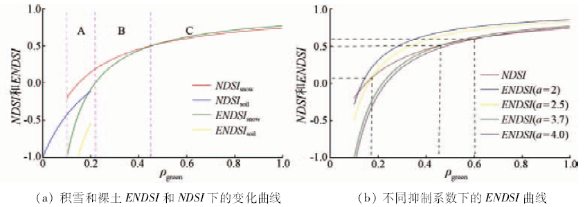
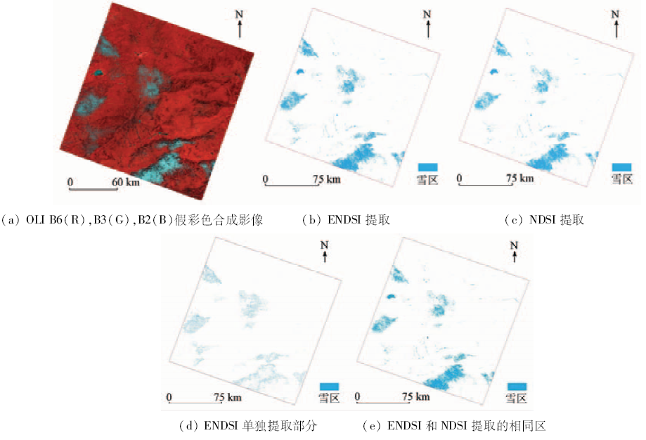
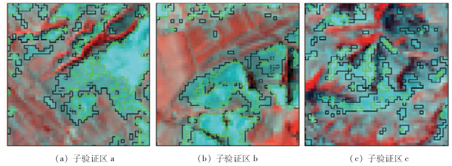
Abstract Detecting snow cover information and snow space-time distribution quickly and accurately is a basic problem of ecological environment changes in the resources. Remote sensing technology effectively provides technical support for solving this problem. Normalized difference snow index (NDSI) is an important method for automatic extracting snow cover information using spectral features of snow, which have high reflection in the green band (0.53~0.59 μm) and strong absorption characteristics in short wave infrared band (1.57~1.65 μm). By using Landsat8 OLI images as the data source and according to the spectral characteristics of snow, the authors propose the enhanced normalized difference snow index (ENDSI) based on adding emissivity characteristics of snow in first band B1 (0.433~0.453 μm) and second band B2 (0.450~0.515 μm), and the utilization of this index to extract snow from OLI images. Simulation and case study results show the following characteristics: the sensitivity of ENDSI is stronger than that of NDSI for the snow thickness; with the increase of the thickness of snow, the change of ENDSI value is stronger than that of NDSI; ENDSI can effectively increase the difference between snow and non-snow; it is easy to extract snow from the image with 0.3 as ENDSI threshold and, in this way, snow extraction accuracy is improved.
|
| Keywords
ENDSI
NDSI
snow
Landsat8 OLI
|
|
|
|
Issue Date: 08 February 2018
|
|
|
| [1] |
Jones H G,Pomeroy J W,Walker D A,et al.Snow Ecology:An Interdisciplinary Examination of Snow-covered Ecosystems[M].Cambridge:Cambridge University Press,2001.
|
| [2] |
白淑英,吴奇,史建桥,等.青藏高原积雪深度时空分布与地形的关系[J].国土资源遥感,2015,27(4):171-178.doi:10.6046/gtzyyg.2015.04.26.
|
| [2] |
Bai S Y,Wu Q,Shi J Q,et al.Relationship between the spatial and temporal distribution of snow depth and the terrain over the Tibetan Plateau[J].Remote Sensing for Land and Resources,2015,27(4):171-178.doi:10.6046/gtzyyg.2015.04.26.
|
| [3] |
郝晓华,王建,李弘毅.MODIS雪盖制图中NDSI阈值的检验——以祁连山中部山区为例[J].冰川冻土,2008,30(1):132-138.
|
| [3] |
Hao X H,Wang J,Li H Y.Evaluation of the NDSI threshold value in mapping snow cover of MODIS:A case study of snow in the Middle Qilian Mountains[J].Journal of Glaciology and Geocryology,2008,30(1):132-138.
|
| [4] |
Xiao X M,Shen Z X,Qin X G.Assessing the potential of VEGETATION sensor data for mapping snow and ice cover:A normalized difference snow and ice index[J].International Journal of Remote Sensing,2001,22(13):2479-2487.
|
| [5] |
王国亚,毛炜峄,贺斌,等.新疆阿勒泰地区积雪变化特征及其对冻土的影响[J].冰川冻土,2012,34(6):1293-1300.
|
| [5] |
Wang G Y,Mao W Y,He B,et al.Changes in snow covers during 1961—2011 and its effects on frozen ground in Altay Region, Xinjiang[J].Journal of Glaciology and Geocryology,2012,34(6):1293-1300.
|
| [6] |
Kour R,Patel N,Krishna A P.Assessment of relationship between snow cover characteristics(SGI and SCI) and snow cover indices(NDSI and S3)[J].Earth Science Informatics,2015,8(2):317-326.
|
| [7] |
于泓峰,张显峰.光学与微波遥感的新疆积雪覆盖变化分析[J].地球信息科学学报,2015,17(2):244-252.
|
| [7] |
Yu H F,Zhang X F.Retrieval and analysis of snow-covered days in Xinjiang based on optical and microwave remote sensing data[J].Journal of Geo-Information Science,2015,17(2):244-252.
|
| [8] |
纪鹏,郭华东,张露.近20年西昆仑地区冰川动态变化遥感研究[J].国土资源遥感,2013,25(1):93-98.doi:10.6046/gtzyyg.2013.01.17.
|
| [8] |
Ji P,Guo H D,Zhang L.Remote sensing study of glacier dynamic change in West Kunlun Mountains in the past 20 years[J].Remote Sensing for Land and Resources,2013,25(1):93-98.doi:10.6046/gtzyyg.2013.01.17.
|
| [9] |
彦立利,王建.基于遥感的冰川信息提取方法研究进展[J].冰川冻土,2013,35(1):110-118.
|
| [9] |
Yan L L,Wang J.Study of extracting glacier information from remote sensing[J].Journal of Glaciology and Geocryology,2013,35(1):110-118.
|
| [10] |
惠凤鸣,田庆久,李英成,等.基于MODIS数据的雪情分析研究[J].遥感信息,2004,19(4):35-38.
|
| [10] |
Hui F M,Tian Q J,Li Y C,et al.Research on snow condition analysis based on MODIS data[J].Remote Sensing Information,2004,19(4):35-38.
|
| [11] |
Hall D K,Riggs G A,Salomonson V V.Development of methods for mapping global snow cover using moderate resolution imaging spectroradiometer data[J].Remote Sensing of Environment,1995,54(2):127-140.
|
| [12] |
赵军,付杰文,付鹏.雪盖指数法提取积雪范围信息的不确定性研究——以玛纳斯上游地区为例[J].遥感技术与应用,2014,29(2):293-299.
|
| [12] |
Zhao J,Fu J W,Fu P.Accuracy and uncertainty of snow information based on NDSI:A case study of upstream region of Manas River[J].Remote Sensing Technology and Application,2014,29(2):293-299.
|
| [13] |
陈文倩,丁建丽,孙永猛,等.基于NDSI-NDVI特征空间的积雪面积反演研究[J].冰川冻土,2015,37(4):1059-1066.
|
| [13] |
Chen W Q,Ding J L,Sun Y M,et al.Retrieval of snow cover area based on NDSI-NDVI feature space[J].Journal of Glaciology and Geocryology,2015,37(4):1059-1066.
|
| [14] |
Satir O.Comparing the satellite image transformation techniques for detecting and monitoring the continuous snow cover and glacier in Cilo Mountain chain Turkey[J].Ecological Indicators,2016,69:261-268.
|
| [15] |
裴欢,房世峰,覃志豪,等.基于遥感的新疆北疆积雪盖度及雪深监测[J].自然灾害学报,2008,17(5):52-57.
|
| [15] |
Pei H,Fang S F,Qin Z H,et al.Remote sensing-based monitoring of coverage and depth of snow in northern Xinjiang[J].Journal of Natural Disasters,2008,17(5):52-57.
|
| [16] |
赵军,陈恺悦,师银芳.提高森林覆盖区积雪提取精度的方法研究——以玛纳斯河流域为例[J].遥感技术与应用,2015,30(6):1051-1058.
|
| [16] |
Zhao J,Chen K Y,Shi Y F.Methods research to improve the extraction accuracy of snow under forest cover:A case study of Manas River basin[J].Remote Sensing Technology and Application,2015,30(6):1051-1058.
|
| [17] |
徐涵秋,唐菲.新一代Landsat系列卫星:Landsat8遥感影像新增特征及其生态环境意义[J].生态学报,2013,33(11):3249-3257.
|
| [17] |
Xu H Q,Tang F.Analysis of new characteristics of the first Landsat8 image and their eco-environmental significance[J].Acta Ecologica Sinica,2013,33(11):3249-3257.
|
| [18] |
魏玥. 北疆区域积雪深度变化的遥感监测研究[D].乌鲁木齐:新疆师范大学,2010.
|
| [18] |
Wei Y.Remote Sensing Monitoring of Snow Depth Change in North Part of Xinjiang[D].Urumqi:Xinjiang Normal University,2010.
|
| [19] |
郝晓华,王杰,王建,等.积雪混合像元光谱特征观测及解混方法比较[J].光谱学与光谱分析,2012,32(10):2753-2758.
|
| [19] |
Hao X H,Wang J,Wang J,et al.Observations of snow mixed pixel spectral characteristics using a ground-based spectral radiometer and comparing with unmixing algorithms[J].Spectroscopy and Spectral Analysis,2012,32(10):2753-2758.
|
| [20] |
闪旭,刘志辉,张波.新疆军塘湖流域融雪期不同积雪及雪被地物光谱反射率特征分析[J].安徽农业科学,2014,42(3):853-855,887.
|
| [20] |
Shan X,Liu Z H,Zhang B.Study of spectrum reflectance characteristics of snow and snow-covered land surface objects in the melting-snow period[J].Journal of Anhui Agricultural Sciences,2014,42(3):853-855,887.
|
| [21] |
程熙,沈占锋,骆剑承,等.利用地物波谱学习的遥感影像波段模拟方法[J].红外与毫米波学报,2010,29(1):45-48,62.
|
| [21] |
Cheng X,Shen Z F,Luo J C,et al.Method on simulating remote sensing image band by using ground-object spectral features study[J].Journal of Infrared and Millimeter Waves,2010,29(1):45-48,62.
|
| [22] |
吴晓晨,孟令奎,张东映,等.冰雪遥感监测方法综述[J]. 水利信息化, 2013(1):35-39.
|
| [22] |
Wu X C,Meng L K,Zhang D Y,et al.Overview on methods of snow and ice remote sensing monitoring[J]. Water Resources Informatization, 2013(1):35-39.
|
| [23] |
刘玉洁,郑照军,王丽波.我国西部地区冬季雪盖遥感和变化分析[J].气候与环境研究,2003,8(1):114-123.
|
| [23] |
Liu Y J,Zheng Z J,Wang L B.Remote sensing on snow cover and variation analyzing in west of China[J].Climatic and Environmental Research,2003,8(1):114-123.
|
|
Viewed |
|
|
|
Full text
|
|
|
|
|
Abstract
|
|
|
|
|
Cited |
|
|
|
|
| |
Shared |
|
|
|
|
| |
Discussed |
|
|
|
|
 2018,
Vol. 30
2018,
Vol. 30