|
|
 |
|
|
|
|
Design and development of an information system for the accounting of state-owned land resource assets |
HUANG Tao1( ), LIU Xiaoping2, WU Jiaping3,4(), XIAO Yanling1, ZHANG Yuchen1 ), LIU Xiaoping2, WU Jiaping3,4(), XIAO Yanling1, ZHANG Yuchen1 |
1. Guangdong Provincial Land and Resources Technology Center, Guangzhou 510075, China
2. School of Geograhy and Planning, Sun Yat-sen University, Guangzhou 510275, China
3. Key Laboratory of Carbon Neutral and Territorial Spatial Optimization, Ministry of Natural Resources, Nanjing 210023, China
4. Guangdong Guodi Resources and Environment Research Institute, Guangzhou 510650, China |
|
|
|
|
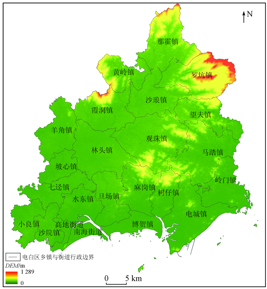
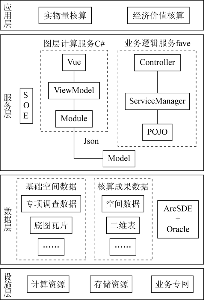
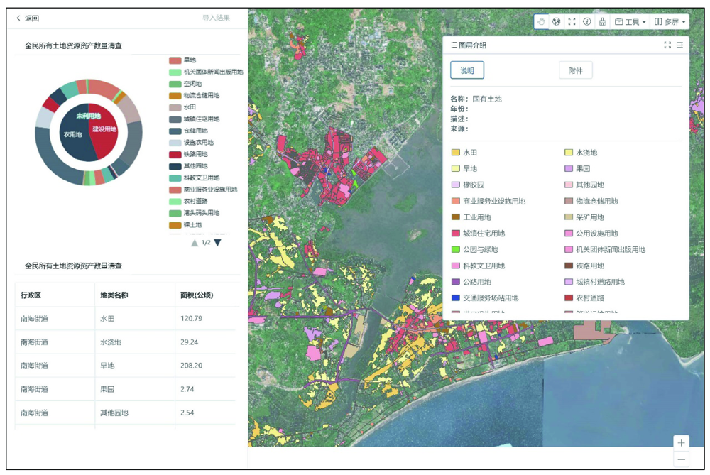
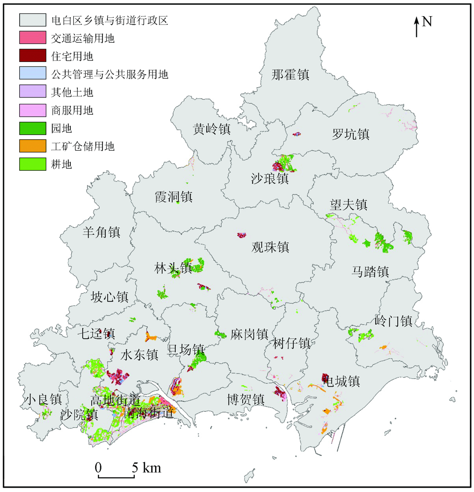
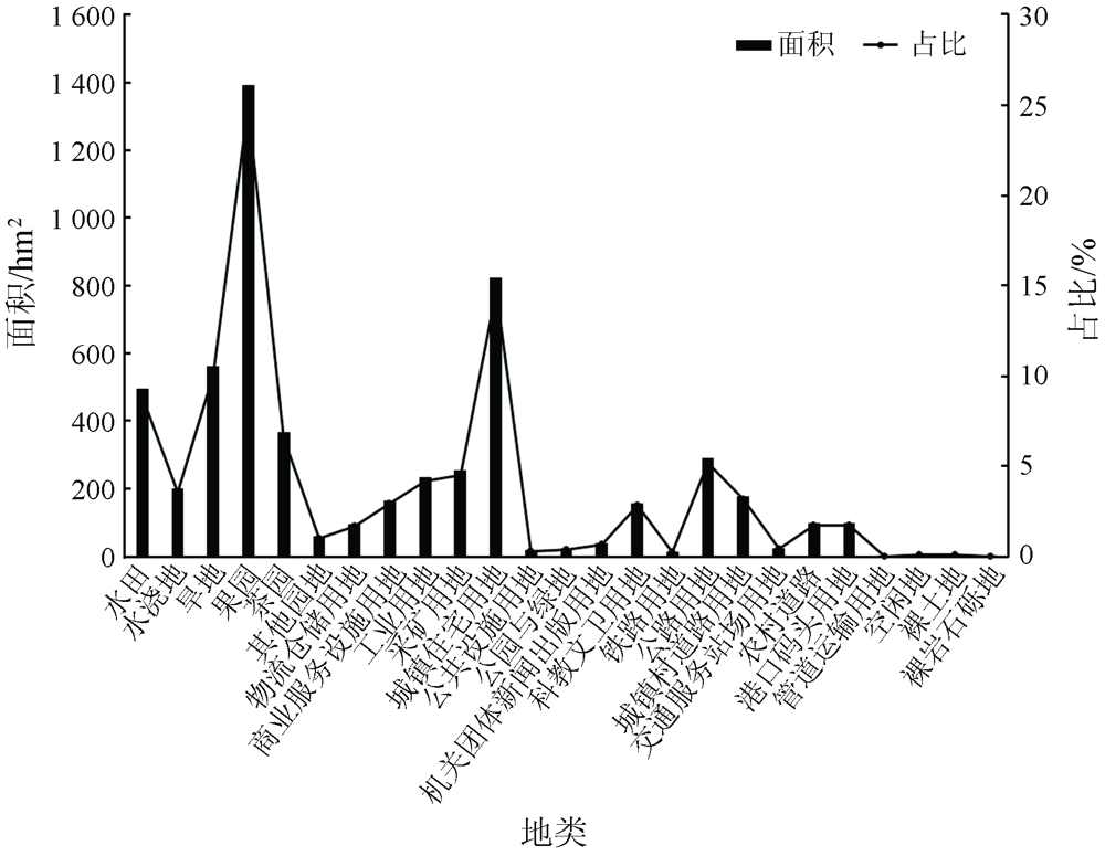
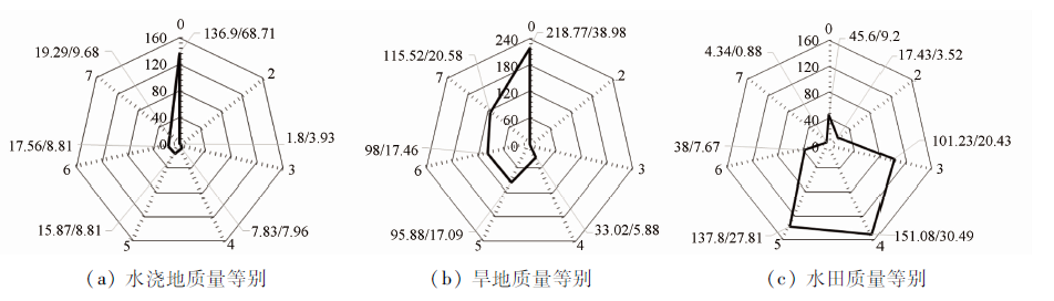
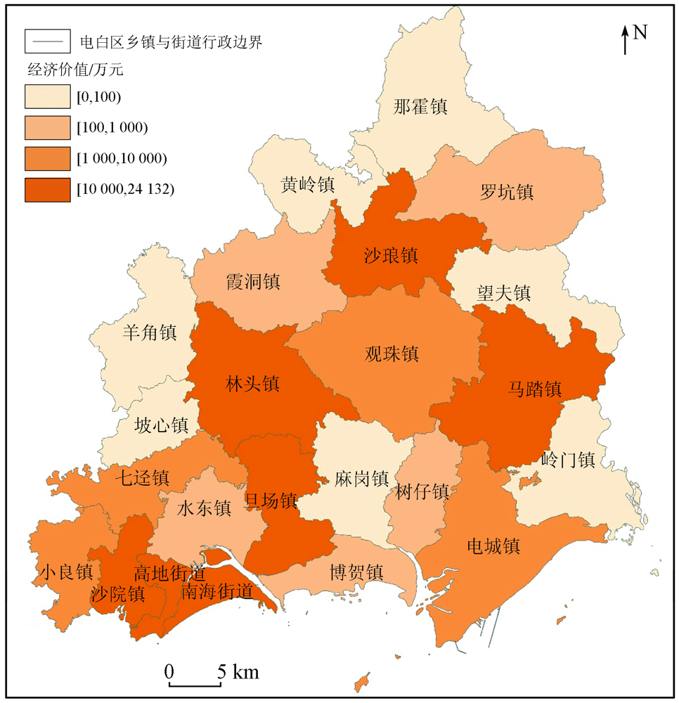
Abstract Accounting for natural resource assets is the main part in ascertaining the state-owned natural resource assets and is also a fundamental task in determining various natural resources. It is of great practical significance to design and develop an information system for the accounting treatment of state-owned land resource assets. Taking the accounting treatment of the state-owned land resource assets in Dianbai District, Guangdong Province as an example, this study designed and developed an automatic accounting system of state-owned land resource assets using the WebGIS integrated architecture based on the data from land surveys, parcels of land, and benchmark land prices and following the methods and procedures for the accounting treatment of state-owned land resource assets. The research results are as follows. The state-owned land resources in Dianbai District have a total area of 5 582.31 hm2, among which, the cultivated land has an area of 1 255.94 hm2. There is a small amount of high-quality cultivated land, with the second-class land only covering an area of 17.43 hm2. The economic value of state-owned agricultural land and construction land is approximately RMB 1 397.360 5 million and RMB 1 639.014 4 million, respectively. The results of this study will provide technical references for ascertaining the state-owned natural resource assets and preparing the balance sheets, thereby promoting the information-based management of natural resource assets.
|
| Keywords
land survey
accounting of state-owned natural resources assets
physical quantity
economic value
WebGIS
|
|
|
|
Corresponding Authors:
WU Jiaping
E-mail: 29461695@qq.com;732446002@qq.com
|
|
Issue Date: 21 September 2022
|
|
|
| [1] |
杨海乐, 危起伟, 陈家宽. 基于选择容量价值的生态补偿标准与自然资源资产价值核算——以珠江水资源供应为例[J]. 生态学报, 2020, 40(10):3218-3228.
|
| [1] |
Yang H L, Wei Q W, Chen J K. Quantifying the payments for ecosystem services and the value of natural resources based on the indicator of optional capacity value:A case study on water resources supply in Zhujiang River basin,China[J]. Acta Ecologica Sinica, 2020, 40(10):3218-3228.
|
| [2] |
薛智超, 闫慧敏, 杨艳昭, 等. 自然资源资产负债表编制中土地资源核算体系设计与实证[J]. 资源科学, 2015(9):43-49.
|
| [2] |
Xue Z C, Min H M, Yang Y Z, et al. Design and empirical study of a land resource accounting system for natural resources asset balance-sheet compilation[J]. Resources Science, 2015(9):43-49.
|
| [3] |
陈玥, 杨艳昭, 闫慧敏, 等. 自然资源核算进展及其对自然资源资产负债表编制的启示[J]. 资源科学, 2015, 37(9):1716-1724.
|
| [3] |
Chen Y, Yang Y Z, Yan H M, et al. Natural resources accounting and the natural resources balance sheet[J]. Resources Science, 2015, 37(9):1716-1724.
|
| [4] |
孔含笑, 沈镭, 钟帅, 等. 关于自然资源核算的研究进展与争议问题[J]. 自然资源学报, 2016, 31(3):363-376.
|
| [4] |
Kong H X, Shen L, Zhong S, et al. Research progress and controversial issues of natural resources accounting[J]. Journal of Natural Resources, 2016, 31(3):363-376.
|
| [5] |
朱道林, 杜挺. 中国耕地资源资产核算方法与结果分析[J]. 中国土地科学, 2017, 31(10):23-31.
|
| [5] |
Zhu D L, Du T, Accounting method and result analysis of cultivated land resource asset in China[J]. China Land Sciences, 2017, 31(10):23-31.
|
| [6] |
朱道林, 张晖, 段文技, 等. 自然资源资产核算的逻辑规则与土地资源资产核算方法探讨[J]. 中国土地科学, 2019, 33(11):1-7.
|
| [6] |
Zhu D L, Zhang H, Duan W J, et al. Discussion on the logical rules of natural resources asset accounting and the methods of land resource asset accounting[J]. China Land Sciences, 2019, 33(11):1-7.
|
| [7] |
张颖, 潘静. 中国森林资源资产核算及负债表编制研究——基于森林资源清查数据[J]. 中国地质大学学报(社会科学版), 2016(6):46-53.
|
| [7] |
Zhang Y, Pan J. Research on China’s forest resource asset accounting and liability sheet compilation:Based on forest resource inventory data[J]. Journal of China University of Geosciences(Social Sciences Edition), 2016(6):46-53.
|
| [8] |
孙东明, 曾文华. 通用行业地理信息综合采集平台的设计与实现[J]. 测绘科学, 2020, 45(6):7.
|
| [8] |
Sun D M, Zeng W H. Design and implementation of universal industry geographic information acquisition platform[J]. Science of Surveying and Mapping, 2020, 45(6):7.
|
| [9] |
余健, 童秋英, 朱波, 等. 一种混合应用模式的土地执法核查APP的设计与实现——以武汉市国土规划执法监察移动系统为例[J]. 测绘通报, 2018(1):151-156.
|
| [9] |
Yu J, Tong Q Y, Zhu B, et al. Design and implementation of the hybrid-pattern-based land investigation APP:Taking Wuhan City land planning law enforcement monitoring mobile system as an example[J]. Science of Surveying and Mapping, 2018(1):151-156.
|
| [10] |
糜新宇. 基于开源WebGIS的时态森林资源管理系统研建[D]. 长沙: 中南林业科技大学, 2017.
|
| [10] |
Mi X Y. The research and design on information system of temporal forest resource management based on open source WebGIS[D]. Changsha: Central South University of Forestry & Technology, 2017.
|
| [11] |
曾映敏, 吕孟. 基于WebGIS的“五小水利”工程在线发布[J]. 测绘通报, 2019(s1):263-265.
|
| [11] |
Zeng Y M, Lyu M. The online publication system of five mini-conservancy projects based on WebGIS[J]. Bulletin of Surveying and Mapping, 2019(s1):263-265.
|
| [12] |
王庆众, 赵相伟, 杨军, 等. 一种土壤修复工程的智能监管方法[J]. 测绘科学, 2019, 44(3):15-20.
|
| [12] |
Wang Q Z, Zhao X W, Yang J, et al. An intelligent subervision method for soil remediation project[J]. Science of Surveying and Mapping, 2019, 44(3):15-20.
|
| [13] |
王玉杰, 邸志众. “二调”与“三调”土地分类对照转换研究[J]. 测绘标准化, 2019, 35(2):6.
|
| [13] |
Wang Y J, Di Z Z. On land classification conversion between the second and the third national land surveying[J]. Standardization of Surveying and Mapping, 2019, 35(2):6.
|
| [14] |
闫慧敏, 封志明, 杨艳昭, 等. 湖州/安吉:全国首张市/县自然资源资产负债表编制[J]. 资源科学, 2017, 39(9):1634-1645.
doi: 10.18402/resci.2017.09.03
|
| [14] |
Yan H M, Feng Z M, Yang Y Z, et al. First report of the national natural resources balance sheet for Huzhou City and Anji County[J]. Resources Science, 2017, 39(9):1634-1645.
|
| [15] |
石薇, 徐蔼婷, 李金昌, 等. 自然资源资产负债表编制研究——以林木资源为例[J]. 自然资源学报, 2018(4):541-551.
|
| [15] |
Shi W, Xu A T, Li J C, et al. Study on the preparation of natural resources balance sheet: A case study of forest resources[J]. Journal of Natural Resources, 2018(4):541-551.
|
| [16] |
喻莹莹, 李新, 陈远平. 前后端分离的终端自适应动态表单设计[J]. 计算机系统应用, 2018, 27(4):70-75.
|
| [16] |
Yu Y Y, Li X, Chen Y P. Design of terminal adaptive dynamic form based on frontend-backend separation[J]. Computer Systems & Applications, 2018, 27(4):70-75.
|
| [17] |
Psaila G. Virtual DOM:An efficient virtual memory representation for large XML documents[C]// International Workshop on Database & Expert Systems Applications.IEEE, 2008.
|
| [18] |
焦鹏珲. 基于SpringBoot和Vue框架的电子招投标系统的设计与实现[D]. 南京: 南京大学, 2018.
|
| [18] |
Jiao P H. Design and implementation of electronic bidding system based on SpringBoot and Vue framework[D]. Nanjing: Nanjing University, 2018.
|
| [19] |
张玉珠. 基于Vue. js框架的掌上零售系统的设计与实现[D]. 武汉: 华中科技大学, 2019.
|
| [19] |
Zhang Y Z. Design and implementation of the palm retail system based on Vue.js framework[D]. Wuhan: Huazhong University of Science & Technology, 2019.
|
| [20] |
陈俊明. SOE技术在测绘成果网络分发服务系统中的应用研究[J]. 测绘与空间地理信息, 2016(7):104-105.
|
| [20] |
Chen J M. A application of SOE in web distribution service system for surveying and mapping results[J]. Geomatics & Spatial Information Technology, 2016(7):104-105.
|
| [21] |
徐亮. 基于ArcGIS Server的服务器对象扩展方法研究[J]. 测绘与空间地理信息, 2016, 39(1):67-69.
|
| [21] |
Xu L. Study of method about server object extension based on ArcGIS Server[J]. Geomatics & Spatial Information Technology, 2016, 39(1):67-69.
|
| [22] |
Johnson R, Hoeller J, Arendsen A, et al. Spring,Java/J2EE Application Framework[EB/OL]. https://docs.spring.io/spring-framework/docs/1.2.x/reference/index.html.
url: https://docs.spring.io/spring-framework/docs/1.2.x/reference/index.html
|
| [23] |
刘敬兵, 于锦涛, 于林松, 等. 山东省农业地质“一张图”系统的设计与实现[J]. 山东农业大学学报(自然科学版), 2021, 52(3):496-499.
|
| [23] |
Liu J B, Yu J T, Yu L S, et al. Design and implementation of “one map” system of agricultural geology in Shandong Province[J]. Journal of Shandong Agricultural University (Natural Science Edition), 2021, 52(3):496-499.
|
| [24] |
赵永辉, 郭新望, 曹霞, 等. 河南省水污染自动监控地理信息系统设计[J]. 河南大学学报(自然科学版), 2019, 49(5):559-566.
|
| [24] |
Zhao Y H, Guo X W, Cao X, et al. Design of geographic information system for water pollution automatic monitoring in Henan Province[J]. Journal of Henan University(Natural Science), 2019, 49(5):559-566.
|
|
Viewed |
|
|
|
Full text
|
|
|
|
|
Abstract
|
|
|
|
|
Cited |
|
|
|
|
| |
Shared |
|
|
|
|
| |
Discussed |
|
|
|
|
 2022,
Vol. 34
2022,
Vol. 34